Partnership to bring integrated precision GNSS solutions to automotive and industrial customers
Swift Navigation, a San Francisco-based GNSS firm, and Taoglas, a provider of internet of things (IoT) solutions, have announced a strategic partnership to integrate their technologies to deliver pre-tested, low-risk, high-precision GNSS solutions to a broad customer base.
The Taoglas EDGE RTK Starter Kit has high-precision GNSS with U.S. 4G/3G cellular connectivity. (Photo: Taoglas)
The partnership will provide positioning solutions for automotive, micromobility, delivery, robotic and industrial customers. Specifically, the Taoglas EDGE Locate IoT platform and EDGE RTK Starter Kit now come pre-integrated with Swift’s Skylark precise positioning service.
Bringing pre-integrated, high-accuracy positioning products to these industries in an easy-to-implement solution will greatly improve the accuracy of the positioning data delivered, the companies state.
Together, Swift and Taoglas deliver high-precision GNSS solutions to customers around the globe by utilizing Taoglas’ IoT platforms and Swift’s Skylark seamless, cloud-based corrections — available in advanced SSR (state space representation) or industry-standard formats. The pre-integration allows customers to bypass module-level validation, integration and engineering efforts with an out-of-the-box solution.
“Swift Navigation is excited to begin this partnership with Taoglas and align our visions of making accurate positioning easily accessible across industries,” said Swift CEO Timothy Harris. “We look forward to offering our products as an integrated solution to make it easier for customers across the globe to benefit from affordable and accurate positioning.”
“We are delighted to be partnering with Swift Navigation to enable companies to overcome the challenges of delivering their high-precision positioning-based IoT solutions.,” said Ronan Quinlan, co-founder and joint CEO of Taoglas. “Our worldwide team of design, development, test and manufacturing engineers is dedicated to delivering IoT software and hardware solutions on time, the first time, for leading technology enterprises.”
Additional products will soon be available from Swift, Taoglas and their channel partners. Customers have the ability to pre-order now by contacting [email protected] or [email protected].
As a new member of the DIFI Consortium, WORK Microwave will help advance the digitization of satellite communication ground technologies
WORK Microwave, a leading European manufacturer of advanced satellite communications equipment, today announced that it has joined the Digital Intermediate Frequency Interoperability (DIFI) Consortium, an independent space-industry group that formed to advance interoperability in satellite and ground-system networks.
As a new member of DIFI Consortium, WORK Microwave joins a growing roster of leading organizations in the space industry committed to bringing innovation to the digital transformation of space, satellite and related technologies.
“With the new space boom and LEO constellations emerging, digitization of the ground segment plays a key role in scalability and sustainability,” said Jörg Rockstroh, director of business development and digital products at WORK Microwave. “Being a prime supplier of satellite communications equipment, WORK Microwave actively supports standardization and other industry-wide efforts to simplify the ecosystem. Joining the DIFI Consortium is an excellent opportunity to help shape the future digitization of the satellite communication ground segment.”
WORK Microwave is an early adopter of new technologies, including digital signal processing, modem infrastructures, optical communication and Q-/V-band equipment. As a long-term contributor to industry standardization, the company has a history of helping advance satellite communication ground technology.
“The DIFI Consortium’s goal is to provide a simple, open, interoperable digital IF/RF standard that replaces the natural interoperability of analog IF signals and helps prevent vendor lock-in,” said Stuart Daughtridge, chair of DIFI Consortium. “We welcome WORK Microwave to the group and look forward to seeing how they will contribute to moving interoperability forward across space networks.”
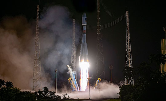
Russia’s space agency Roscosmos is suspending cooperation with Europe on space launches from the Kourou spaceport in French Guiana, including future Galileo satellite launches.
As reported by Rueters, Roscosmos chief Dmitry Rogozin said Saturday the action is in response to Western sanctions over Russia’s invasion of Ukraine.
“In response to EU sanctions against our companies, Roscosmos is suspending cooperation with European partners on space launches from Kourou, and is withdrawing its technical staff…from French Guiana,” Rogozin said in a post on his Telegram channel.
Russia’s decision will have “no consequences on the continuity and quality of Galileo and Copernicus services,” EU Commissioner Thierry Breton said in a statement. “This decision does not call into question the continuity of the development of these infrastructures either.”
“We are also ready to act with determination, together with the Member States, to protect these critical infrastructures in the event of an attack.”
“We will, in due course, take all the necessary decisions in response and resolutely pursue the development of the second generation of these two sovereign space infrastructures of the Union,” Breton said. “We are also prepared to act determinedly together with the member states to protect these critical infrastructures in case of an attack, and to continue the development of Ariane 6 and VegaC to guarantee the strategic autonomy with regard to carrier rockets.”
The Galileo program had already planned to shift to using Ariane 6 rockets for satellite launches. The launcher is undergoing the final stages of development, led by prime contractor ArianeGroup.
From 2023 onward, the remaining Galileo Batch 3 satellites will be launched with the new Ariane 62 launch vehicle, a variant of Ariane 6 with two strap-on solid boosters.
The most recent Galileo satellite launch took place on Dec. 5, 2021, using Soyuz launcher VS-26 to carry the first pair of Galileo Batch 3 satellites into orbit. The announcement will delay a Soyuz launch of two more Galileo satellites scheduled for April from French Guiana; a third pair of Galileo satellites was scheduled to launch in autumn on another Soyuz.
Galileo launch 11 from Europe’s spaceport in French Guyana. (Photo: ESA/CNES/Arianespace)
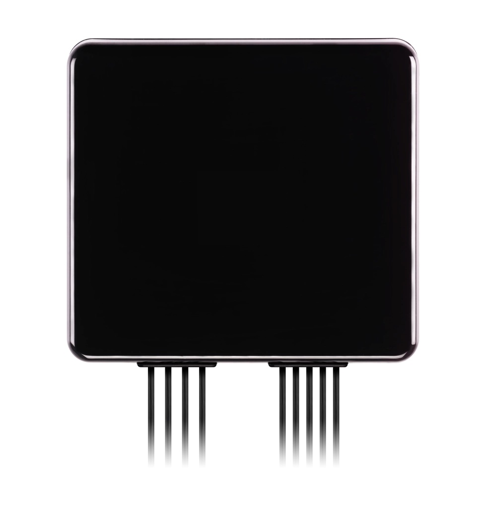
Taoglas announced its smallest 9-in-1 combination antenna with dual-band GNSS and high-performance 5G/4G, the Taoglas MA990 Guardian.
Taoglas made the announcement at Mobile World Congress (MWC) Barcelona 2022, which takes place Feb. 28–March 3; Taoglas is exhibiting at booth #5E32.
The Taoglas MA990 Guardian antenna is a small 9-in-1 combination antenna with dual-band GNSS (L1/L2) and globally supported cellular (5G/4G). It has been designed to support emerging market demand for modules that cover specific 5G/4G bands.
For example, two of its eight cellular MIMO antennas cover from 600 to 6,000 MHz, while another two are optimized for 3,000 to 6,000 MHz to cover high-band 5G and C-band/CBRS applications. The product is designed to operate on all carrier networks globally and is future-proofed to work with latest 5G routers in the market.
Housed in a low-profile, robust, IP67-rated waterproof, adhesive-mount external enclosure, the MA990 is designed for space-constrained, mission-critical applications, including asset and vehicle tracking, first- responder vehicles and high-definition video sources such as surveillance cameras.
The Taoglas MA990 also is highly customizable, including for any variation of antennas below 9-in-1 and the addition of Wi-Fi/single-band GNSS.
Russia’s military could target GPS and communication satellites as part of its war in Ukraine, reports Space News.
The news outlet cites U.S. National Reconnaissance Office (NRO) Director Christopher Scolese speaking Feb. 23 at the National Security Space Association’s Defense and Intelligence Space Conference.
“I think we’re seeing pretty clearly that Russia is committed to doing what they want to do in Ukraine, and they want to win,” Scolese said. “So I think it’s fair to assume that, to the extent that they can, and to the extent that they feel it won’t extend the conflict out of their control, that they will extend it into space.”
An attempt to disrupt the United States’ space ability could affect satellites of private operators as well, such as Maxar, which is distributing imagery of the conflict.
A next-generation GPS III satellite on orbit. (Artist’s Rendering: Lockheed Martin)
In mid-November, Russia destroyed a retired satellite with a ground-based anti-satellite (ASAT) weapon. This created significant debris, which endangered other assets in low-Earth orbit, including the International Space Station (ISS). Two Russian cosmonauts were serving on the seven-person ISS crew at the time.
Based on the ASAT demonstration and unclassified reports from the U.S. Director of National Intelligence, it is pretty clear that Russia can destroy all, or at least most, GPS satellites in one go.
What is less clear, is whether Russia would really do that.
To find out, Dana A. Goward spoke with George Beebe, who once served as the Central Intelligence Agency’s top analyst for Russia and Eastern Europe. He is now the director of programs at the Center for the National Interest, a center-right think tank.
Dana A. Goward: Russia’s threat to destroy GPS was made shortly after they destroyed an old satellite in space. What do you make of that demonstration, and all the dangerous debris it created?
George Beebe: Well, they were clearly sending a message — several messages, in fact. First, of course, that they have the ability to destroy satellites in space. This is part of a larger narrative they want to tell — that they are a world power which must be reckoned with. And it is no coincidence that this was done while they were amassing troops along Ukraine’s borders.
Another message is that they know the U.S. and Europe are very dependent on space, and we are vulnerable there.
DG: But the space debris will threaten satellites and people in low-Earth orbit for years to come. That seems to be reckless and counter to their own interest.
GB: While others see that as reckless and irresponsible, Russian officials almost certainly see it as an expression of resolve. That was actually another message. They were saying, “We are willing to endanger our own equipment and people.”
Translate that to their concern about keeping Ukraine from joining NATO and otherwise falling into the West’s sphere of influence. It might be, “We are willing to accept the pain in order to keep Ukraine from leaving our orbit.”
Unfortunately, I am not sure most Western leaders picked up on the “We are resolved” message.
DG: Attacking GPS would be a huge, devastating and dangerous move, though. How could things get so bad they would do that?
Beebe is the author of The Russia Trap. (Cover: Thomas Dunne Books)
GB: Russia sincerely believes it is generally threatened by the West, and specifically by NATO.
Since the fall of the Soviet Union, they have seen their global influence recede, and Western influence on their borders greatly expand. Some of their neighbors have joined NATO. Others, like Ukraine, have not, but would like to eventually come under the NATO umbrella. For the Kremlin, this is unacceptable. It is akin to what Soviet missiles in Cuba were for the United States.
Over the last decade and a half, Putin has rebuilt the Russian military. He is now looking to draw lines in the sand for the West to not cross.
At the same time, the West feels threatened by Russia. Hitler’s aggression and refusal to be appeased by territorial concessions is standard reading in every Western history class. American and European leaders feel compelled to hold the line and not give into what they see as Putin’s territorial ambitions.
This is a very dangerous situation as both sides see themselves acting defensively and the other acting aggressively.
DG: I guess it is much easier to justify something to yourself and your compatriots if you think you are only acting in self-defense.
GB: Exactly. The problem comes when one side does something in self-defense and, in response, the other side feels compelled to do something as well. This can spawn an escalating tit-for-tat that spirals out of control into a bigger conflict no one wants.
DG: The West is imposing economic sanctions. At least that is harder to interpret as aggressive.
GB: Before World War II, the U.S. imposed severe economic sanctions on Japan in response to its expansionist moves in Asia. The sanctions were so severe that they were crippling and threatened to bring down Japan’s military government. The week before Pearl Harbor, the Japanese delivered a diplomatic note to the United States saying the sanctions amounted to an act of war. So, economic sanctions are not always an absolutely safe route.
DG: Do you think Russia would ever really attack GPS? And how might that go down?
GB: It depends on how backed into a corner they feel. They certainly know that our military and our homeland are very dependent on GPS, and we have no real alternative in place. It doesn’t help that they are much less dependent on GLONASS and have an alternative for when signals from space are not available.
So, they can definitely do more harm to us than we can to them by interfering with navigation satellites.
It would take a lot to goad them into physically attacking GPS satellites. That would be an irreversible step they undoubtedly understand could lead to all-out war.
Far more likely would be a cyber-attack on the systems controlling the GPS constellation. Such an attack could be harder to attribute to them. It could also be reversed if they got what they wanted.
I could also see them jamming GPS and Galileo signals across Europe and the United States as part of an escalated conflict. Russian forces excel at electronic warfare, and the jamming could easily be turned off once they achieved their goals, or if things seemed to be getting out of hand.
Photo: Stanislav Ostranitsa/iStock/Getty Images Plus/Getty Images
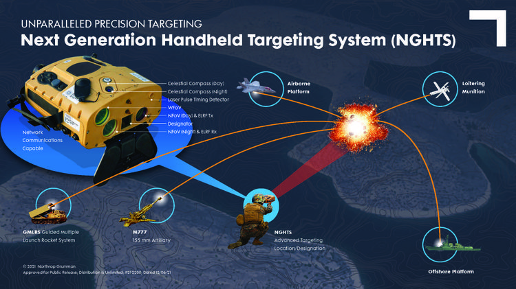
The U.S. Marine Corps has selected Northrop Grumman to provide the Next Generation Handheld Targeting System (NGHTS), a compact device that provides precision targeting and is capable of operation in GPS-denied environments.
The laser-based device will give marines an enhanced capability to identify and designate targets from extended ranges.
“NGHTS will significantly enhance the ability of marines to identify ground targets under a wide range of conditions,” said Bob Gough, vice president, navigation, targeting and survivability, Northrop Grumman. “Connected to military networks, NGHTS can provide superior situational awareness and accurate coordinates for the delivery of effects from beyond the line of sight.”
Northrop Grumman’s NGHTS is capable of performing rapid target acquisition, laser terminal guidance operation and laser spot imaging functions. Its high-definition infrared sensors provide accuracy and grid capability over extended ranges. Additional features include a high-definition color display and day/night celestial compasses.
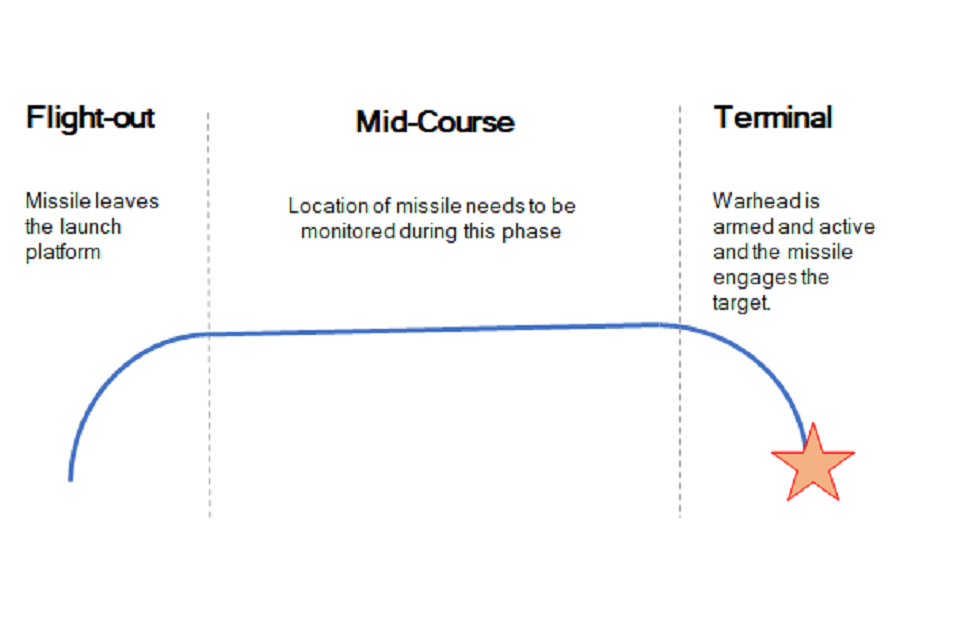
The United Kingdom has issued a market exploration document for alternative navigation for weapon systems to support GNSS.
Specifically, UK Defence Equipment and Support (DE&S) and the Defence and Security Accelerator (DASA) want to understand the range of technologies used for commercial positioning and navigation systems. Its main area of interest is to know the location of the weapon during the mid-course phase of deployment, as shown in the figure below, with an accuracy of ±5 meters. Technology guidance to the final target is not part of the scope.
Project focus is location of the weapon during the mid-course phase of deployment with an accuracy of ±5 meters. (Image: UK Defence)
With GNSS vulnerable to jamming and spoofing, the exploration is interested in supporting navigation and positioning technologies, such as:
Terrain contour matching (TERCOM): uses a radar altimeter and a digital terrain elevation database.
Digital scene matching (DSMAC): matches an onboard image to an imagery database.
Inertial navigation systems (INS) or inertial measurement units (IMU): rely on accurate measurements of velocity and time to calculate position.
The market exploration is part of a larger Technology Demonstration Program. The defense agencies recently ran an Innovation Focus Area looking at quantum navigation systems, and selected several proposals for funding.
Quantum technology is not specifically out of scope for this exploration, but the agencies are specifically looking for technologies that could be developed to a testing and trialling prototype within the next three years.
Russian military doctrine assumes GLONASS and other GNSS will not be available once a battle begins, so will instead turn to Loran-C for navigation
Russian forces are expert at jamming and spoofing GNSS. As a result, military analysts say, Russian military doctrine assumes that signals from space, including it’s own GLONASS and other GNSS, will not be available once a battle begins.
According to the Russia and CIS Radionavigation Plan, the terrestrial Chayka system, a version of Loran-C, is maintained to protect their homeland with navigation and timing services when signals from space are not available. The portable Skorpion system is designed for military use during expeditions to areas where Chayka or Loran is not available, according to western military analysts.
“Fixed Chayka transmission sites operate between 90 Khz and 110 Khz. Power output is typically between 200 and 800 kW with effective ranges over land of about 800 miles and over water of 1,000 miles,” explained Dana Goward, president of the Resilient Navigation and Timing Foundation. He noted that little information is publicly available about the military Skorpion system.
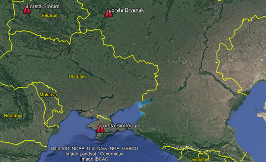
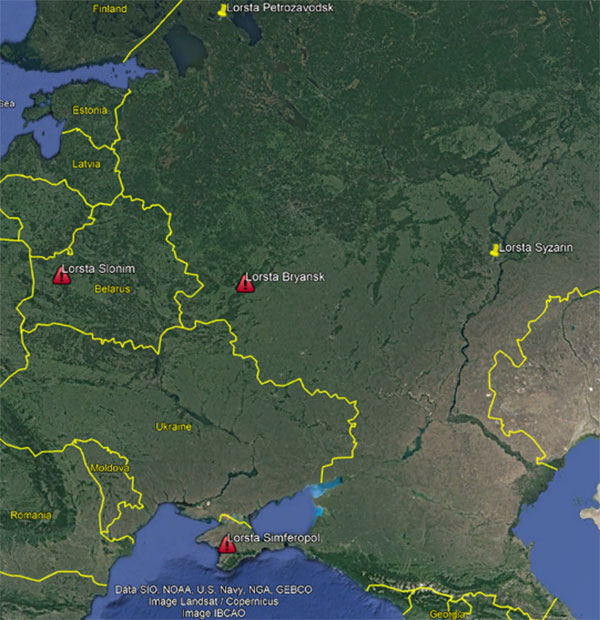
“Three of Russia’s Chayka/Loran stations have Ukraine surrounded,” explained UrsaNav CEO Charles Schue, referring to a graphic he provided GPS World. “They provide ideal coverage and will allow navigation accuracy of between 20 and 50 meters over most of the Ukraine. Upgrading to an eLoran equivalent could give them 5-to-10-meter accuracy, but I am sure the current setup is more than adequate for their purposes at the moment.”
Image: Charles Schue, UrsaNav
Schue was the first commanding officer of the U.S. Coast Guard’s Loran Support Unit and the first program manager for the congressionally mandated Loran Modernization and Recapitalization project that was upgrading the U.S. Loran-C system to eLoran. As CEO of UrsaNav, he is helping several countries with Loran-C and eLoran projects.
One of the three surrounding Loran transmission sites is in the Crimea, which Russia invaded and annexed in 2014.
“The primary reason for taking Crimea may have been ensuring access to the ocean,” Schue said, “but it also allowed them to regain control of the Loran transmission site there. This has assured them sovereign terrestrial PNT [positioning, navigation and timing] for the entire region, including the Black Sea.”
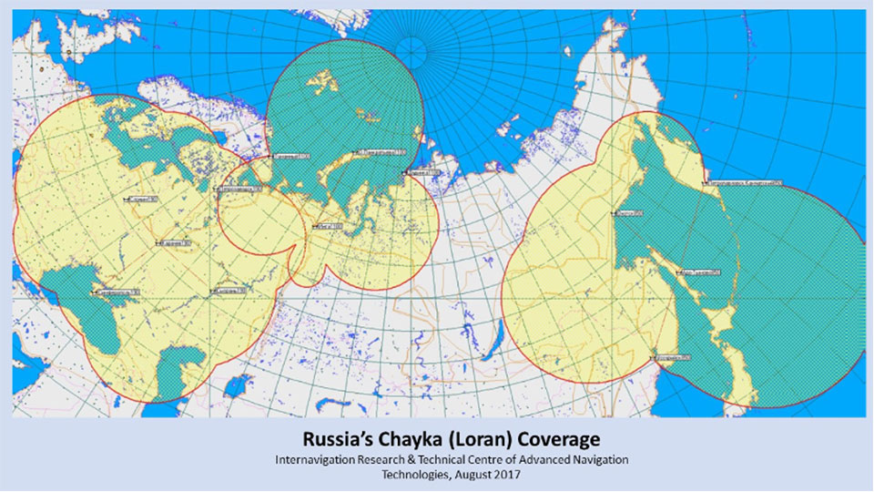
A 2017 coverage map from Russia’s Internavigation Research and Technical Centre of Advanced Navigation shows Chayka serving eastern Europe, western Russia, and almost all of the Black Sea.
Image: Russia’s Internavigation Research and Technical Centre of Advanced NavigationImage: Russia’s Internavigation Research and Technical Centre of Advanced Navigation
Canada is leveraging advanced surveillance capabilities to enhance safety and efficiency by implementing a new mandate that will require aircraft operators flying in certain domestic airspace to meet Automatic Dependent Surveillance – Broadcast (ADS-B) Out performance requirements.
ADS-B uses GNSS technology to calculate an airplane’s precise location, speed and direction. This information is transmitted twice per second, providing greater situational awareness for air traffic controllers. It also provides increased flexibility to accommodate airline and customer preferred routes.
The mandate will take effect in Class A and B Canadian airspace above 12,500 feet on Feb. 23, 2023.
“ADS-B is a foundational building block for our future airspace and operations,” said Raymond G. Bohn, president and CEO of Nav Canada. “The Canadian equipage mandate — when combined with Nav Canada’s space-based surveillance capabilities — will enhance safety and service.”
“The aviation sector plays an essential role in connecting Canadians to each other and the world,” said the Honourable Omar Alghabra, Minister of Transport. “We welcome advancements and innovation that enhance the safety and environmental sustainability of our transportation networks and supply chains.”
The equipage requirements of Canada’s ADS-B mandate are in line with a growing number of other countries in the world, and the adoption of satellite-based surveillance technology ensures long-term alignment with the global aviation system.
Space-based ADS-B is already being used and delivering safety and efficiency benefits to suitably equipped aircraft over Hudson Bay, the North Atlantic and in domestic airspace above 29,000 feet in Canada. In December 2021, Nav Canada began providing service to appropriately equipped aircraft below 29,000 feet in the Montreal Flight Information Region and plans to expand to the Edmonton and Winnipeg Flight Information Regions later this year, prior to the mandate going into effect in 2023.
Future implementation of a mandate in areas within Class C, D and E will leverage a phased approach to help achieve the maximum benefits of a performance-based mandate for Canadian airspace. Aircraft operators and owners will have adequate time to meet the equipage requirements to use space-based ADS-B technology across the country. Implementation in these classes of airspace, to occur no sooner than 2026, will be determined pending further assessment.
About the ADS-B mandate
To meet the ADS-B Out mandate, aircraft will be required to:
Be equipped with an appropriate transponder with ADS-B Out capabilities and performance with the applicable standard of Radio Technical Commission for Aeronautics (RTCA) DO-260B, “Minimum Operational Performance Standards” or newer.
Have antenna capability for broadcast toward space-based ADS-B receivers emitting 1090 MHz extended squitter. This requirement can be met either through antenna diversity (the use of a top and a bottom antenna) or with a single antenna capable of transmitting both toward the ground and up toward satellites.
The European Space Agency is looking for navigation and positioning ideas, with its Navigation Innovation and Support Programme (NAVISP) seeking input by March 31.
NAVISP is divided into a trio of elements. Element 1’s scope of activities ranges from initial feasibility studies and viability analyses all the way to full proof of concept for promising positioning, navigation and timing (PNT) systems and services.
To compile its annual Element 1 workplan, NAVISP invites innovative PNT concepts from companies or academic entities across NAVISP participating states. Those interested can submit a 1-page description, along with notifying their national ESA delegation of their application. See details here.
NAVISP Industry Days took place in 2020 at at ESA’s ESTEC, The Netherlands. (Photo: ESA)
The NAVISP Element 1 workplan supports cutting-edge European companies in development of novel PNT technologies and services. Underscoring the commercial priority of this field, 20 ESA Member States plus Canada have joined the program.
PNT underpins a 10th of Europe’s economy, according to ESA, in areas such as transport, precision agriculture, power, communication, banking and the fast-growing internet of things.
Satellite navigation, with signals from space extending across the globe, represents the single biggest source of PNT information, but these signals are not available in all locations and are vulnerable to natural or human-made interference.
NAVISP Element 1 is focused on innovation in PNT, involving novel concepts, techniques, technologies and systems along the entire value chain. They often combine GNSS with other solutions such as artificial intelligence, other sensors, adding Wi-Fi or 5G signals to PNT fixes, or employing high-altitude atmospheric platforms to supplement GNSS coverage over regions in need.
Hemisphere GNSS has added to its lineup another Vega heading and positioning OEM board that uses Lyra II and Aquila chipset technology — the Vega 34. The Vega 60 board was previously announced as using the Lyra II and Aquila chipsets.
Hemisphere’s Lyra II and Aquila application-specific integrated circuit (ASIC) designs simultaneously track and process more than 1,100 channels from all GNSS constellations and signals including GPS, GLONASS, Galileo, BeiDou, QZSS, NavIC, SBAS and L-band.
Integrators who use predecessor Hemisphere 34-pin products, such as Crescent Vector H220 and Phantom 34 OEM boards, can easily transition to the improved positioning performance and the superior satellite tracking abilities of the Vega series, the company said.
The Vega 34 board connectors have no circuitry changes and are identical for all Vector users, enabling them to add Atlas H10 and H30 precise point positioning (PPP) into their solutions.
“Vega 34 gives our integrators an easy path forward to enrich their own product offerings,” said Miles Ware, director of marketing at Hemisphere. “For the first time, Crescent Vector integrators can upgrade to multi-frequency without changing pinouts. They can also take advantage of other standard features like more than 1,100 tracking channels, Cygnus interference mitigation technology and spectral analysis.”
NavIC Upgrade. The introduction of the Vega 34 board also brings a new firmware release. Version 6.05 extends several features and improvements and introduces NavIC (IRNSS) tracking and positioning across the entire Vega and Phantom product lines.
Both real-time kinematic and Atlas positioning solutions are enhanced with improved performance in challenging environments. Users of the BeiDou satellite systems and B2b PPP integrators also will see significant advances in their solutions.