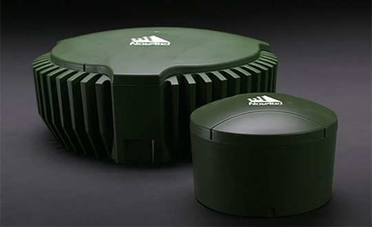
NovAtel’s GPS Anti-Jam Technology (GAJT) product lines achieved a milestone of thousands of units shipped worldwide in 2020. Despite COVID-19, 2020 has proven to be one of NovAtel’s most successful years in protecting positioning, navigation and timing (PNT) from cyber electromagnetic activities (CEMA) for military and civil organizations, the company stated in a press release.
Jamming and interference are growing threats, from a crowded RF spectrum to malicious jamming attempts. However, the GNSS market is responding with anti-jam technologies. Across the world — on land, in the air and at sea — NovAtel customers use GAJT to protect their GNSS navigation and precise timing receivers from intentional jamming and unintentional interference.
The GAJT portfolio includes commercial off-the-shelf solutions with short order lead times for rapid deployment. The range of products can be readily integrated into new platforms or retrofitted into legacy fleets.
Photo: Hexagon | NovAtel
The GAJT-710, its smaller counterpart GAJT-410 and the GAJT-AE variants are used worldwide to protect PNT against jamming and interference no matter the environment.
Beyond defense, GAJT enables users to be proactive against cyber electromagnetic activities using situation awareness technology to indicate the presence and direction of jamming signals.
“Jamming and interference are growing threats worldwide. GAJT protects our customers no matter where they operate,” said Steve Duncombe, executive VP of Aerospace and Defense at NovAtel. “We’re proud to achieve this milestone during a challenging 2020 and will continue delivering assured positioning in our customers’ critical applications with extremely short delivery times.”
Germany is the first United States ally to order the new military code (M-code)-capable Military GPS User Equipment (MGUE).
The Space and Missile Systems Center’s Space Production Corps achieved the major milestone on Sept. 30, when GPS Foreign Military Sales (FMS) office received its first M-code MGUE order.Germany is expected to receive delivery of its first M-code receivers this year.
SMC is facilitating international access and availability of M-code user equipment as directed by the Secretary of the Air Force and the Office of the Secretary of Defense to 58 authorized nations. Additional foreign military sales of MGUE are being worked.
Currently, SMC is engaged with several nations in bilateral M-code prototyping, demonstration and lead platform planning efforts. Under a multilateral agreement, MGUE ground-based receivers are on schedule to be loaned to approved partners for early integration and test in national weapons systems.
M-code is an upgrade to the currently available GPS signals that provides enhanced secure positioning, navigation and timing (PNT) performance, anti-jam and anti-spoofing to provide a more resilient PNT solution. It will improve interoperability with our defense partners’ equipment and operations while increasing navigation warfare effectiveness for allied operations.
The conference will be hosted by the Military Division of the Institute of Navigation for the Department of Defense and Department of Homeland Security. Its theme will be “Enhancing Dominance and Resilience for Warfighting and Homeland Security PNT.”
The FEDCON U.S.-only sessions will take place at the Northern Kentucky Convention Center in Covington, Kentucky, Aug. 24-26; and the U.S.-only secret sessions will be held at the Air Force Institute of Technology, WPAFB in Dayton, Ohio, Aug. 27. The JNC 2021 exhibit hall will be open Aug. 25-26.
This decision to change the date and host the conference in person was made in consideration of the forecasted Spring 2021 global accessibility of the COVID-19 vaccine.
“We have made this decision to ensure our attendees feel safe gathering at ION events,” said Lisa Beaty, executive director at ION. “There appears to be good reason for optimism that our military PNT community will be able to gather again soon.”
According to ION, JNC is the largest U.S. military positioning, navigation and timing (PNT) conference of the year with joint service and government participation. The event focuses on technical advances in PNT with emphasis on joint development, test and support of affordable PNT systems, logistics and integration.
According to a new market research report, “Anti-Jamming Market for GPS with COVID-19 Impact, by Receiver Type (Military and Government Grade and Commercial Transportation Grade), Technique (Nulling, Beam Steering and Civilian), End-User, Application and Geography — Global Forecast to 2025,” the anti-jamming market for GPS is valued at $4 billion in 2020 and is expected to reach $5.9 billion by 2025.
The report, published by MarketsandMarkets, also states that the market is expected to grow at a CAGR of 7.9% from 2020 to 2025. Some of the key factors driving this growth include high demand for GPS technology in military applications and ongoing developments to improve overall GPS structure. Factors such as the growing demand for unmanned airborne vehicles and systems and the development of low-cost GPS anti-jamming solutions also are expected to provide growth opportunities to players in the GPS anti-jamming market.
According to the report, Nulling Technique is expected to hold largest share of GPS anti-jamming market from 2020 to 2025. In addition, surveillance and reconnaissance are expected to hold largest share of GPS anti-jamming market during the forecast period.
The GPS anti-jamming market in Asia Pacific is expected to grow significantly, as a result of a rise in the number of terror attacks in the region, which has led to countries enhancing their surveillance and antiterrorism capabilities, the report added. Countries in this area are also manufacture defense aircraft, which is expected to increase the scope of GPS anti-jamming for defense and aerospace systems. An increase in the defense expenditures of India and China, among other countries, and the expansion of militaries in emerging economies also have accelerated the demand for GPS anti-jamming solutions in Asia Pacific.
Raytheon Technologies, Hexagon, Thales Group, L3Harris Technologies, BAE Systems, Cobham, Mayflower Communications, infinDome, Lockheed Martin, Israel Aerospace Industries, Furuno Electric and Meteksan Defense are few major players in the GPS anti-jamming market.
MarketsandMarkets provides B2B research on 30,000 niche opportunities/threats that will impact 70% to 80% of worldwide companies’ revenues, the research firm said.
The Space and Missile Systems Center’s Production Corps achieved a major GPS milestone on Nov. 18 with the approval for Operational Acceptance of GPS Military-Code (M-Code) Early Use (MCEU). MCEU serves as a gap filler for M-code operations before the entire GPS constellation’s operational transition to the Next Generation Operational Control System Block 1.
The encrypted M-code signal enhances anti-jamming and anti-spoofing capabilities for the warfighter. M-code signals are available on all 23 GPS Block IIR-M, IIF and III space vehicles currently on orbit. The successful testing events were completed at the Master Control Station at Schriever Air Force Base, Colorado and Alternate Master Control Stations at Vandenberg Air Force Base, California.
Operational Acceptance followed successful integrated developmental and operational testing of the GPS Operational Control Segment (OCS) upgrade. Operating in a trial period since June 2020, the MCEU upgrade allows the OCS Architecture Evolution Plan to task, upload and monitor M-code within the GPS constellation, as well as support testing and fielding of modernized user equipment. With M-code now declared operational, upcoming Military GPS User Equipment (MGUE) will be able to request early use of the M-code signal-in-space to provide more secure position, navigation and timing (PNT) to warfighters.
“MCEU ushers in a new era of GPS support that will provide operators across the warfighting domain with assured PNT access while further preventing unauthorized use by our adversaries. This is a critical step in remaining the gold standard of PNT systems and promoting a peaceful, secure, stable, and accessible space domain,” said Lt. Jordan Malara, 2nd Space Operations Squadron GPS Warfighter Collaboration Cell assistant flight commander.
M-code designed for security
Military code (M-Code) is a more-secure, harder-to-jam and spoof GPS signal specifically for military forces. Awarded in September 2017, M-Code Early Use (MCEU) is a software upgrade to the OCS AEP, which allows the current ground control system to task, upload and monitor M-Code within the GPS constellation. It will also help Accelerating M-Code’s deployment supports testing and fielding of modernized user equipment in support of the warfighter.
MCEU includes a new software-defined receiver installed globally at all six Space Force Monitoring Sites. The M-code Monitor Station Technology Improvement and Capability (M-MSTIC) uses commercial, off-the-shelf hardware to cost effectively receive and process M-code signals, enabling OCS operators to successfully monitor the M-code signals.
“M-code’s more-secure, harder-to-jam and spoof signals are critical to helping our warfighters complete their missions, especially in contested environments,” said Maria Demaree, vice president and general manager for Lockheed Martin’s Mission Solutions line of business. “This upgrade to the current GPS ground control system, and the launch of more modernized GPS III satellites, is making M-code’s full-fielding a reality.”
With the Dec. 1 Operational Acceptance of GPS III Space Vehicle 04 (GPS III SV04), 23 GPS IIR-M, GPS IIF and GPS III satellites broadcast M-code in the current GPS Constellation.
Ground Control Timeline — OCS AEP
Lockheed Martin has sustained the Space Force’s current GPS ground control system since 2013. The system is known as the GPS Operational Control Segment (OCS) Architecture Evolution Plan (AEP) or “OCS AEP.”
In February 2016, the Air Force contracted Lockheed Martin to develop the GPS III Contingency Operations (COps) software upgrade to the OCS AEP. COps was delivered in May 2019, successfully connected with on-orbit GPS III SV01 in October 2019, and was Operationally Accepted in February 2020. COps enabled the Air Force’s ground control system to command and control both the legacy satellites, as well the more powerful GPS III satellites beginning to launch.
In November 2018, the company completed the AEP 7.5 upgrade — the largest architectural change in the systems history — replacing significant code, hardware and software to improve the system’s cybersecurity capabilities and positioning the Air Force to better operate in contested, degraded and operationally limited environments.
In December 2018, the Air Force awarded Lockheed Martin the GPS Control Segment Sustainment II (GCS II) contract to continue to further modernize and sustain the OCS AEP through 2025.
In the fourth quarter of 2019, Lockheed Martin delivered the Red Dragon Cybersecurity Suite (RDCSS) Phase III upgrade to the OCS AEP, dramatically improving Defensive Cyber Operations (DCO) visibility into GPS network traffic. Other add-ons include user behavior analytics to analyze patterns of traffic and network taps to improve data collections.
Earlier this year — and key to enabling M-Code — Lockheed Martin installed new software-defined M-Code Monitor Station Technology Capability (M-MSTIC) receivers at six Space Force monitoring sites around the world. In Dec. 2019, SMC granted security approval for M-MSTIC.
From his side window, a crew chief relays vital position information back to the CH-47 Chinook pilot as paratroopers hook their pallet of equipment to the underside of the helicopter during sling load and air operations training. (Photo: U.S. Army/Maj. Robert Fellingham)
Coalition gives voice to PNT companies seeking open-market approach to backing up GPS/GNSS for critical infrastructure
Several GNSS and positioning, navigation and timing (PNT) companies have joined forces to create a new lobbying group, the Open PNT Industry Alliance. Founding companies include InfiniDome, Iridium Communications, Jackson Labs Technologies, NAVSYS Corporation, NextNav, OPNT, Orolia, Qulsar, Satelles and Seven Solutions.
In the United States, the coalition believes the Executive Order on “Strengthening National Resilience Through Responsible Use of Positioning, Navigation, and Timing Services,” issued in February 2020 begins the process for a national alternative PNT policy.
The report was criticized by some lawmakers for inaccuracies and lack of depth, but several companies whose solutions were referenced in the report defended it, and have now joined in creating this new alliance.
The alliance expects to support similar initiatives in other countries.
The coalition is designed to fortify economic and national security by supporting government efforts to accelerate the implementation of backup PNT capabilities for critical infrastructure. Other companies sharing these views are invited to join the alliance.
The Open PNT Industry Alliance will be introduced in an Orolia PNT Coffee Talk webinar on Thursday, Dec. 17, at 10 a.m. EST.
A serious problem facing nations around the world is that GPS and other GNSS are susceptible to inadvertent disruptions and deliberate attacks. Such incidents have the potential to impair or incapacitate communications networks, transportation systems, energy production and distribution platforms, financial services operations and other types of critical infrastructure.
With the scope, complexity and severity of disruptions and attacks evolving continuously, the combination of wide-ranging PNT solutions and emerging technologies offers superior protection to current threats by providing a backup to GPS/GNSS and improving national resilience.
“Multiple forms of alternative PNT deliver the broadest possible range of operational and performance characteristics to meet the diverse needs of applications across all industry sectors, plus they can better adapt to future threats than a single technology with its inherent vulnerabilities,” said Michael O’Connor, CEO of Satelles. “The mission of the Open PNT Industry Alliance is to promote open-market concepts that preserve industry’s long-term ability to harness its inventive talent to protect GPS/GNSS with multiple solutions that are technologically advanced, commercially viable, and based on a sustainable long-term funding framework.”
The Open PNT Industry Alliance will share its expertise with governments to aid their efforts to set policies, define regulations, and enact laws that achieve their national resilience objectives while preserving competition in the open market. A principal purpose of the coalition is to stimulate and capitalize on the collective intellect of industry in a collaboration between the public sector and private sector.
“The ingenuity of the private sector is spurred by competition and public and private investment, and this will drive the emergence of multiple GPS/GNSS alternatives that are cost-effective and evolve according to threat profiles, technological innovations, and market dynamics,” said Jean-Yves Courtois, CEO of Orolia. “Similarly, unbridled innovation will address new and still evolving use cases not supported by GPS/GNSS.”
The coalition will work closely with governments as they consider plans for regulation of critical infrastructure sectors and funding for alternative PNT. Legislators and policymakers can best pursue national interest through a multi-technology approach to PNT resilience, the coalition stated in a press release. The coalition will advocate for the establishment of a robust and self-sustaining funding framework that allows for the development and adoption of multiple sources of PNT that meet the needs of various sectors and industries.
“We believe a multi-technology approach to PNT resilience not only meets a more diverse set of critical infrastructure needs but also ensures a more robust approach to security by providing multi-layer resilience,” said Ganesh Pattabiraman, CEO of NextNav. “Delivering alternative PNT capabilities on an equal footing with GPS will require government policies and funding that ensure these solutions are cost-effective for critical infrastructure providers and sustainable over the long term.”
FLIR Systems Inc. has acquired Altavian Inc., a privately held manufacturer of small unmanned aerial systems (sUAS) for defense and public-safety customers.
Altavian’s airframes integrate multiple sensors, including FLIR thermal technology, to provide users with decision support and intelligence, surveillance and reconnaissance (ISR) capability.
Based in Gainesville, Florida and founded in 2011, Altavian designs and manufacturers Group 1 UAS solutions for long or short range operations. With both quadcopter and fixed-wing UAS designs, Altavian’s expertise includes aeronautics, avionics, and software, and its solutions are engineered around an open system architecture aligned to the needs of government and defense customers.
Altavian is one of five drone manufacturers approved by the U.S. Department of Defense under the Blue sUAS program to sell to the U.S. military and federal agencies.
“Altavian’s proven engineering expertise and assets will allow us to offer customers the most comprehensive solution portfolio of any American sUAS provider,” said Roger Wells, general manager of the Unmanned Systems and Integrated Solutions business of FLIR Systems’ Defense Technologies Segment, under which Altavian will be integrated. “With the addition of both a low-cost, rapidly deployable quadcopter and a longer range fixed-wing UAS, FLIR is strengthening its already impressive drone lineup, including our Black Hornet and SkyRaider platforms used extensively by militaries around the globe. We’re excited about the multiple new franchise opportunities FLIR will be able to pursue for defense, public safety, and industrial markets worldwide.”
For more information about FLIR Systems’ existing sUAS solutions, visit flir.com/defense-uas.
The fourth GPS III satellite, space vehicle (SV) 04, received United States Space Force’s Operational Acceptance approval on Dec. 1.
Operational acceptance marks another significant milestone for the GPS III program, Space and Missile Systems Center and USSF, according to the Space Force. This is the fourth GPS III satellite delivered into the operational constellation in the past 12 months and the second in the past three months.
Also, this is the first GPS III vehicle delivered to the warfighter through an expedited satellite control authority transfer process, which cuts 10 days off the previous operational acceptance timeline.
One more to go for M-code capability
“With the onset of SV04, the GPS constellation continues moving forward in next generation modernization,” said Capt. Collin Dart, the 2 SOPS DOA flight commander. “The 2nd Space Operations Squadron is one step closer to providing military code (M-code) capability for the entire 24 satellite baseline.”
“The highly encrypted M-code to protect GPS signals from jamming and spoofing is currently enabled on 22 GPS satellites of various generations; 24 are needed to bring the M-code to the next level of operational capability,” Dart explained. “SV04 brings the constellation to 23 M-code capable vehicles. SV05 will launch no earlier than July 2021. This will add the 24th M-code capable vehicle.”
“M-code signals are more-secure, harder-to-jam and spoof, and are critical to helping our warfighters complete their missions, especially in contested environments,” said Tonya Ladwig, Lockheed Martin’s vice president for Navigation Systems. “GPS III is a warfighting system and we are proud to be helping bring this critical capability to the men and women protecting our nation.”
GPS III SV04 is encapsulated in its protective launch fairings. (Photo: 45th Space Wing Public Affairs)
Faster handover from contractor
SV04 also sets a new standard for handover from contractor Lockheed Martin’s launch team to operational acceptance, setting the satellite healthy to the global user community approximately 30 days post launch, according to Dart. “Moving forward with future GPS III launches, the timeline between launch and the satellite being set healthy will be at a minimum,” he said.
SV04 was launched on a SpaceX Falcon 9 Block 5 vehicle on Nov. 5. The Air Force has been flying 31 operational satellites for years to ensure the United States’ commitment to have 24 operational GPS satellites available 95% of the time.
GPS III SV04 joins this operational constellation of 31 GPS satellites orbiting in medium-Earth orbit. The system delivers improved accuracy, advanced anti-jam capabilities and increased resiliency for the GPS III constellation.
Lockheed Martin’s production proceeds
The Space Force declared GPS III SV05 “Available for Launch” in May. The satellite is waiting to be called up”for launch.
GPS III SV06, 07 and 08 are now fully assembled and going through environmental testing at Lockheed Martin’s GPS III Processing Facility in Denver.
GPS III SV09 and 10 are in component build up.
Lockheed Martin is also under contract for up to 22 additional GPS III Follow On (GPS IIIF) satellites, which introduce further technology and capabilities. In May, Lockheed Martin completed its Critical Design Review for the GPS IIIF and in July, the Space Force declared that GPS IIIF fulfilled “Milestone C,” which means the production phase of the program has officially begun.
“The operational acceptance of GPS III SV04 is another significant milestone for GPS Modernization, delivering critical new capabilities to our Military and Civil Users. We now have a total of 23 M-code spacecraft for our Warfighters. For our billions of civil users, it brings the count up to 23 L2C spacecraft and 16 L5 spacecraft,” said Col. Ryan Colburn, director of the SMC Portfolio Architect Office’s Spectrum Warfare Division. “For professional users with existing dual-frequency operations, L2C enables faster signal acquisition, enhanced reliability, and greater operating range. L5 is broadcast in a radio band reserved exclusively for aviation safety services. It features higher power, greater bandwidth, and an advanced signal design. Future aircraft will use L5 in combination with L1 C/A to improve accuracy (via ionospheric correction) and robustness (via signal redundancy). The operational acceptance of this spacecraft is another display of the fantastic teamwork across SMC’s Corps, Space Delta 8, National Geospatial-Intelligence Agency, Department of Transportation, Federal Aviation Administration, our industry partners and many others who work together to make these missions possible.”
GPS satellites provide position, navigation, and timing to more than four billion military and civilian users worldwide.
A Falcon 9 carrying GPS III SV04 lifts off from Cape Canaveral Air Force Station, Florida, Nov 5. (Photo: SpaceX via USAF)
Cobham Aerospace Connectivity has been selected by General Atomics Aeronautical Systems Inc. (GA-ASI) and the U.S. Army to provide the anti-jam GPS systems for the MQ-1C ER Gray Eagle Extended Range (GE-ER) unmanned aircraft system (UAS) platform.
As part of a multi-domain operation equipment suite that is compatible with existing GE-ER aircraft, the DACU-8 capability provides assured positioning, navigation and timing to the Gray Eagle ER UAS, weapons and sensors. According to Cobham, this modification to the Gray Eagle ER UAS ensures the platform can provide reconnaissance, surveillance and target acquisition and attack capability, even in a GPS contested environment.
The digital antenna control unit (DACU) and controlled radiation pattern array antenna system were chosen for their performance in jammed and benign environments, as well as their ability to output direction finding to on-board systems, Cobham said. This direction-finding capability allows the system to perform as a sensor, enabling the platform to identify, locate and respond to the jamming threat.
“GA-ASI and Cobham collaborated very closely on integration activities and on-platform performance evaluations to deliver cutting edge technology for the U.S. Army,” said Matt Cadwell, North America sales director at Cobham. “Cobham is very proud to support GA-ASI’s leadership through the ‘survive, persist and thrive’ evolution in denied environments. The DACU-8 capability ensures GE-ER’s ability to persist in a contested environment, providing critical RSTA capability in a contested environment, supporting the Army, as well as the joint force.”
The United States Space Force’s Space and Missile Systems Center awarded the Military Global Positioning System User Equipment (MGUE) Increment (Inc) 2 Miniature Serial Interface (MSI) with Next-Generation Application Specific Integrated Circuit (ASIC) to BAE Navigation & Sensor System, L3 Technologies (now L3Harris) and Raytheon Technologies.
According to the U.S. Space Force, the three MSI contracts are valued at $552 million and will be executed as Middle Tier Acquisition rapid prototyping efforts. The first delivery is scheduled for early fiscal year 2026.
Enhanced processing and security features associated with M-code drove the decision to develop a smaller and more powerful receiver card for handheld and dismounted applications, the U.S. Space Force said. The MSI with Next-Generation ASIC will enable Military-Code GPS receiver production, mitigating the obsolescence issue of current ASICs and providing significant security and performance improvements for GPS-enabled weapons systems. MGUE Inc 2 will be compatible with all existing and future spacecraft and ground systems, it added.
MGUE Inc 2 enables military GPS user equipment to receive allied GNSS positioning, navigation and timing (PNT) signals to increase both the resilience and capability of military PNT equipment, and deter attacks on GPS, the U.S. Space Force said. These signals will supplement GPS-based PNT in accordance with Department of Defense policies regarding usage of allied GNSS signals, ensuring identification and mitigation of cyber risks, and compatibility with existing PNT equipment.
Flexible, resilient military PNT designed for every military environment
Orolia, through its Orolia Defense & Security business, has announced the availability of M-code military GPS receivers in its resilient PNT products and solutions, including M-code-enabled mobile mission timing and synchronization platforms.
M-code capabilities further enhance Orolia’s Versa mobile PNT platform for rugged, small SWaP-C requirements and Orolia’s flagship SecureSync resilient time and frequency reference solution — the first Defense Information Systems Agency (DISA) approved time server.
M-code is a military signal used in the L1 and L2 GPS bands and is required by congressional mandate for U.S. Department of Defense (DoD) military operations. It is designed to enhance positioning, navigation and timing (PNT) capabilities and improved resistance to existing and emerging GPS threats, such as jamming and spoofing.
M-code offers several operational benefits, including a higher power signal with improved resistance to jamming and interference; advanced security features to prevent unauthorized access or exploitation; and improved message formats and signal modulation techniques for faster and more accurate performance.
“As threats against GPS increase, military forces will need M-code capabilities on mobile PNT systems to ensure continuous operations wherever they go,” said Hironori Sasaki, president of Orolia Defense & Security. “Orolia is proud to continue to support Department of Defense initiatives to ensure that warfighters have the most secure, reliable and accurate positioning, timing and synchronization solutions in any environment.”
From resilient PNT solutions to GPS/GNSS simulation, interference detection and mitigation, Orolia provides end-to-end NAVWAR and resilient PNT solutions to protect, augment and strengthen military systems for GPS-denied environments.
Tenacity of spirit is one of the great virtues. Supporters of geospatial technology have often had to endure steadfast resolve convincing others of the multi-dimensional value GIS provides. It is a battle best won by seeing and doing rather than by words.
Then, in the early 2000s, due in large part to 9/11, the government’s interest in GIS increased.
It was a necessary evolution. Technologies at the time were rapidly advancing. Computer graphics, computer processing power, the internet, shared databases, GPS, digital imagery, and mobile devices needed to merge. GIS was the only solution to bring them all together.
At the same time, disasters became increasingly destructive. Public safety and emergency management needed solutions, but most of the funding is by the government with tight budgets, so investments into geospatial technologies and specialized staff were limited.
A small group of individuals saw that gap and together they began providing support to the public safety sector. The first organization they were able to work with was the National Association of State Fire Marshalls. Word quickly spread. Soon, other organizations began asking for geospatial services.
Eventually, 11 national organizations came together to provide support, structure and purpose for the fledgling team of GIS volunteers. This group became the founders of the National Alliance for Public Safety GIS (NAPSG) Foundation.
Now, 15 years later, NAPSG has contributed to recovery after every major disaster and many minor ones throughout the United States. Its success extends internationally — NAPSG has helped other countries set up their own public safety GIS support teams.
Image: NAPSG
Membership in NAPSG has grown to more than 65,000. Its members are involved in supporting operations for fires, flooding, search and rescue, earthquakes, storm and tornado damage, health crises, chemical spills, and more. They have become central to emergency management operations, helping coordinate efforts of multiple groups through GIS platforms.
During and after events, NAPSG hosts debriefs to evaluate and improve ongoing and future operations. The result advances the field of public safety. NAPSG also provides education to its constituent communities and makes its training available to the public.
NAPSG and its members are highly valued. Every state GIS council has the group as a point of contact. NAPSG is a trusted entity at the community level up through to the highest levels of the federal government, and they are one of the first calls FEMA makes in a crisis.
Tari Martin
I had the opportunity to interview Tari Martin (GISP), the director of national and federal programs, one of the leaders in NAPSG. Speaking with Tari made me realize that GIS is still early in its adoption phase. Tari is one of the founders of GIS at the state level. Earlier in her career she was the first person in the state of Maryland dedicated to supporting emergency management operations.
She helped build Maryland’s emergency management framework coordinated efforts with the National Incident Management System (NIMS), and she began pulling in federal data such as the Homeland Infrastructure Foundation-Level Dataset (HIFLD) for use in local operations.
Now, Tari serves on the Maryland GIS Council for the Public Safety/Next Generation 911 Subcommittee in addition to her regular duties as a director for NAPSG. Tari also serves as a program manager, working to create a universal symbology for public safety and emergency management.
Maps and map symbology are revered. Map symbology emerged from a long, proud, history of cartography dating back to a time before the Golden Age of Exploration when maps were adorned with beautiful, hand-drawn symbols of wind roses, sea creatures, and exotic plants and animals; including inscriptions, such as that within the cartouche of the Typus Orbis Terrarum (Atlas of the World) by Ortelius in 1573. Therein are inscribed the words from Cicero’s Tusculan Disputations, “Quid ei potest videri magnum in rebus humanis, cui aeternitas omnis, totiusque mundi nota sit magnitudo,” which translated means, “For what human affairs can seem important to a person who keeps all eternity before his eyes and knows the vastness of the universe?”
Map symbology has been more an art than a science driven predominantly to support specific purposes, such as navigation, war, surveying, mining, construction and recreation. Additionally, symbologies may not translate across professions, regions or cultures. Even when the symbols are the same, the colors may be different giving symbols different meanings.
Symbols are a visual language, and as the world becomes increasingly smaller and emergency events more international, the need for the language of maps to become universal is necessary. NAPSG has taken on that challenge, coordinating input from multiple stakeholders.
In essence, NAPSG is working with groups like Urban and Regional Information Systems Association (URISA) to create the Rosetta Stone of map symbology for public safety and emergency management, and Tari Martin is one of the central figures working on that project. The symbol library is free and publicly available on the NAPSG website.
Tari also reminisced about her early days when she first got into GIS just before Hurricane Katrina, and how many of her co-workers in Maryland mobilized to go down and help out with recovery operations. She stated that was one of the moments in her career that cemented her understanding for the value of GIS in post-disaster operations. Tari now teaches a course on GIS in Emergency Management for URISA.
NAPSG is involved in cutting-edge technologies helping to shape and educate the public safety community. Its members are working with autonomous vehicles, indoor mapping technologies, augmented reality and virtual reality, wearables, and other opportunities as they arise.
NAPSG makes its content available online. Explore its best practices, guidance and standards, education and training, events, qualifications and credentialing, toolkits and more. Become a NAPSG member at no cost.
William Tewelow works for the Federal Aviation Administration. He is a graduate of the FAA management fellowship program and while on special assignment to the U.S. Department of Transportation William led a national strategic geospatial project for the White House Open Data Partnership. He is a Geographic Information Systems Professional (GISP) and a Maryland STEMnet Scholar Speaker. He has degrees in Geographic Information Technology and Intelligence Studies, and is currently pursuing a masters degree in Organizational Management. He was among the first in the nation to earn a Geospatial Specialist Certification from the U.S. Department of Labor while working at NASA Stennis Space Center.
William retired from the U.S. Navy after serving 23 years as a Geospatial and Imagery Intelligence Specialist, a Naval Aviator, a Meteorologist, and a Tactical Oceanographer. He is married, enjoys writing, traveling, solving problems, and is fascinated by new technology and historical context. His favorite quote is, “A man’s mind changed by a new idea can never go back to its original dimension.” ~ Oliver Wendell Holmes