Honeywell has produced a new inertial navigation unit that provides accurate navigation for customers across a broad range of industries including agriculture, robotics and autonomous vehicles, without compromising on size, cost or performance.
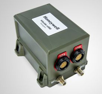
The HGuideN580 inertial navigation technology improves accuracy in urban and rural environments. (Photo: Honeywell)
The HGuide n580 is the first Honeywell-produced, industrial-focused navigation solution that uses both precision inertial measurement unit technology and GNSS to improve location accuracy even when facing natural and manmade obstacles.
“The blend of inertial and satellite navigation capabilities provided by the HGuide n580 is especially important where precision is required in demanding environments — for example, autonomous cars traveling in cities, where our technology can extend the accuracy and performance of navigational systems while keeping passengers safe,” said Chris Lund, senior director, Navigation and Sensors, Honeywell Aerospace. “Honeywell’s history and expertise in navigation technology enables customers to implement this new wave of advanced technology into their own applications and operations.”
Roughly the size of a deck of cards, the HGuide n580 gives Honeywell’s industrial customers the capabilities needed to navigate accurately in areas with limited satellite coverage, such as densely populated cities where tall buildings, underground tunnels, and multi-layer freeway stacks or bridges often create challenges to traditional GPS navigation.
For a GPS unit to function properly, it requires a strong signal connection between the unit on the ground and multiple satellites in the sky to accurately orient its position. City infrastructure such as buildings and tunnels can temporarily block the signal between GPS unit receivers and satellites, creating urban canyons.
With the HGuide n580 integrated system, Honeywell’s inertial measurement unit technology combines with GPS to act as a backup solution, which means the loss of GPS signal caused by an urban canyon does not result in a complete loss of navigation.
To learn more about the new HGuide n580 solution and Honeywell’s other commercially available navigation technologies, visit the Honeywell Aerospace website.
An increasingly bitter political and economic argument between the United Kingdom (U.K.) and the European Union (EU) has alternately stalled and unfrozen progress on Galileo.
Why does this matter from a defense and security viewpoint? Because it’s all about access to Galileo’s Public Regulated Service (PRS), the military-grade service and signal — in addition to billions of pounds and euros.
The byzantine maneuvering on both sides may have further implications, in the form of a much-expanded role for the current European GNSS Agency (GSA), with a corresponding reduction in funding scope for the European Space Agency (ESA).
ESA is not directly affected by the Brexit brouhaha, but indirectly, the impacts mount and extend. ESA is technically independent of the EU, but acts as the union’s procurement body for space programs. It is run by the 22 member states on the ESA council — which crucially includes the U.K., as well as non-EU members Norway and Switzerland. Thus, the Brits, while exiting the union in March 2019, will continue to play a voting role in the space agency.
In an second-round gambit, the U.K. had threatened to use its veto on the ESA council to delay procurement of future Galileo satellites. This was seen as an attempt to bring the EU into negotiations over U.K. access to the highly encrypted Galileo PRS.
A navigation and timing signal restricted to use by authorized government agencies, armed forces, police, emergency and other security services, the PRS is designed to be robust to jamming and spoofing and available even in times of crisis.
Under EU rules, only EU member states can access or work on the PRS. Similar to GPS M-code, PRS could be said to be the prime motivating factor for the origins of the European GNSS: the desire, some would say the compelling requirement, to have a military-grade signal under one’s own control.
The U.K. says it will encounter “significant gaps” in a wide range of areas including prisoner transfers, asset recovery, sharing of financial intelligence, victim compensation and access to criminal records for child protection vetting, should it be shut out from the PRS. This doesn’t begin to reveal the real reason: the ability to conduct military, security and defense operations confidently undertaken with a secure and enrypted GNSS signal.
The European Commission maintains that the U.K. will have to “apply” to use the PRS, like any other non-EU country, tacitly as a “foreign entity.” PRS is for EU member states only.
U.K. companies such as CGI U.K. have developed much of the programming and coding of the PRS signal. Current EU rules bar all U.K. companies from bidding on new contracts unless they transfer their work to EU countries before Brexit. The EU wants CGI U.K. to hand its encryption security intellectual property to the Franco-Italian firm Thales Alenia Espace.
This would poke Britain’s defense ministry where it hurts most: access to the key source codes, and a measure of security in military, defense and police operations. The U.K. government also wishes to retain the encryption expertise and personnel, rather than see them outsourced.
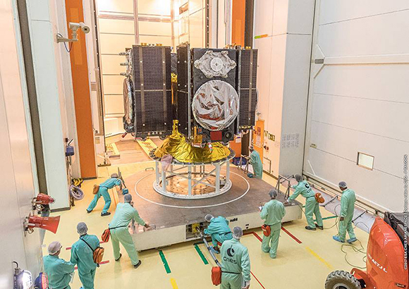
Four Galileo satellites placed in the payload container prior to December 2017 launch, which brought the total Galileo constellation to 22. (Image courtesy of ESA)
Whither GSA?
In a separate but closely related debate within the EU, a strategic repositioning is proposed for the GSA: renaming and remaking it into the EU Agency for the Space Programme. This would not only greatly enlarge its sphere of activity and authority, it could create two sparring space agencies in Europe, one wholly under the control of the EU and one with the maverick U.K. on its ruling council.
A draft EU document states ESA’s decision-making procedures “cannot lead to a call into question of the decisions of the [European] Commission or the European Space Agency within the framework of the actions and space programmes of the union.”
ESA is naturally bitterly opposed to its parent organization creating a rival. It has long struggled — behind closed doors — with its semi-independent, semi-subservient role to the EU, which after all holds the ultimate purse strings.
Some in Europe see indications that the GSA rebadging could lead to a gradual transfer of space funding from ESA to the newly rechristened agency if EU discontent rises. “A creep in power” was the term used by one official.
The EU has long expressed concerns over ESA’s governance of the funds handed to it by the EU for space projects. The long stall in Galileo getting up a full head of steam, a period that could be said to have extended from 2002 to 2008 or thereabouts, was seen by some atop the EU as evidence of ESA over-extension: technically expert but fiscally untrained or unqualified.
Opening Salvos
In what now appears to be a dead issue, the U.K. had first demanded reimbursement for the €1 billion it contributed to Galileo. The EU rejected that out of hand, saying it would not negotiate “under threat.”
In a follow-up, the U.K. claimed that while it wished to continue participating in Galileo, it could well start up its own GNSS if it did not receive adequate access to Galileo PRS. The EU stuck to its guns, so to speak: “Third countries [and their companies] cannot participate in the development of security-sensitive matters.”
The U.K. has also bruited blocking Galileo from use of ground tracking stations in British overseas territories, such as the Falklands.
A U.K. minister stated: “The U.K. genuinely wants to remain a major player in the project, with privileged ongoing access from outside the EU, and views its capabilities and contribution to date as giving it the right to that ticket.”
A European spokesperson countered: “For the EU, the decision to leave inevitably entails relegation to a different role and status in the project, and, let’s be candid, offers scope for EU-located firms to take contractual business away from U.K. ones.”
A Ukranian MIG-29. (Photo: Ministry of Defense, Ukraine)
Ukrainian Lviv Aircraft Repair Plant is upgrading the country’s MIG-29 fighter jets with domestically developed GNSS-assisted navigation capability, reports defenseworld.net.
GNSS data will be viewed on a 8-inch, highly informative Cockpit display alongside the map of the terrain being overflown, target data and weapons parameters.
Also being upgraded is the jet’s air-to-ground and surface attack capability, making it a “multi-role” fighter aircraft.
The air-to-ground capability will be achieved through the use of TV-guided missile-bomb weapons of the X-29T and KAB-500KR types. The MiG-29 was originally designed as an air-superiority fighter to provide cover to ground attack planes such as the MiG-21.
In the spring of 2017, the U.S. Marine Corps Warfighting Laboratory (MCWL) — via the Defense Department’s Defense Innovation Unit Experimental (DIUx) — engaged in a one-year prototype contract with Sensofusion to develop a ground-based mobile counter-UAS solution stemming from Sensofusion’s pre-existing core product Airfence.
Sensofusion acted as lead integrator and further advanced Airfence to integrate radar and optics systems on board vehicles enabling all systems to work in unison, with Airfence being the core counter-UAS solution by means of RF detection and transmission.
The DIUx project has been active for more than 12 months, growing and expanding since its late March 2017 launch.
Airfence is now fully ruggedized, meeting IP67 ruggedization requirements. Furthermore, Airfence has outperformed all tests for range of detection and counterattack capabilities and has also greatly increased the number of drones within its library it can detect, track and defeat yielding zero false positives, Sensofusion said. The system has outperformed range testing at the Marine Corps Base in Quantico, Virginia.
In addition, Airfence exceeded expectations against a large variety of small UAVs — including fixed wings and rotorcrafts — while Marines operated the technology under extreme weather conditions in Arizona at Yuma Proving Grounds. YPG is the largest U.S. military installation in the world and has been a key site for testing military equipment since World War II.
Through its work with the U.S. Marine Corps, Sensofusion has brought its system to a single sensor solution, which is beneficial for tactical use in a mobile convoy scenario.
Airfence also can be used for fixed installations when protecting areas such as military bases, airports, prisons, oil refineries and pipelines, nuclear power plants, power plants, government buildings and border walls.
Sensofusion has made major leaps in its ability to detect and defeat rogue drones by means of protocol demodulation and manipulation.
“Our work in the past year with the Marines enables us to meet production readiness with our flagship counter-UAS solution, AIRFENCE, and are now prepping for production with the Departments of Defense and Homeland Security,” said Sensofusion Vice President Kaveh Mahdavi. “We’re now at a point where DoD, DHS — really, any government organization — can order our standardized counter-UAS platform, Airfence, in large quantities. This is a significant advancement within our developing drone defense industry and will act as the benchmark for all future solutions.”
Extension to Sensofusion-U.S. DoD contract signed. As Sensofusion ramps up production for AIRFENCE across government agencies in America, it continues to align with MCWL, signing a one-year extension to the agreement with the DoD to innovate and implement new capabilities within signal intelligence.
The JNC, sponsored by the Military Division of the Institute of Navigation, will be held July 9-11 in a U.S. only, For Official Use Only (FOUO) environment at the Hyatt Regency Long Beach in Long Beach, California. The U.S.-only classified sessions will be held July 12 at The Aerospace Corporation.
According to ION, early registration can save $200 on conference registration fees by entering a reservation confirmation number from the Hyatt Regency Long Beach at the start of the registration process. Attendees will need a valid hotel confirmation number to claim the discount during registration.
Conference attendance for both FOUO U.S. only (July 9-11) and U.S.-only classified sessions (July 12) will be screened by the Joint Navigation Warfare Center and will be restricted to U.S. only.
Admission to the classified session will be limited to the capacity of the room and will be allocated on a first-come, first-served basis, to those who submitted visit requests in advance. Attendees requiring onsite security validation will be processed on a space-available basis. You are encouraged to submit your visit request early.
TerraGo, a provider of dissemination and collaboration software for defense and intelligence agencies, has announced the availability of R3 for immediate download in the National Geospatial-Intelligence Agency’s (NGA) GEOINT App Store.
R3 is a mobile data collection and collaboration app customized for the missions of reconnaissance, response and recovery. Designed for the most challenging missions and environments, R3 lets users keep working offline and off the grid with customizable workflows for security, humanitarian and disaster relief programs, the company said.
“R3 enhances situational awareness, search and rescue, damage assessments and recovery efforts,” said Scott Lee, director of federal programs at TerraGo. “It really gives users the best of both worlds with mobile technology that can go anywhere, and will also work even when the network doesn’t.”
Image: TerraGo
Designed with a simplified user interface, R3 provides a robust standalone capability for a variety of field-based collection activities. Users can access custom basemaps from numerous GIS, map and imagery sources including GeoPDF, ArcGIS, USGS and GXP, while collecting and exchanging location-tagged notes using smart forms, photos, videos and audio files.
Pre-loaded forms are available for structured assessments, and users can connect to a secure server to create unique mission packages and enable synchronous collaboration. R3 supports important standards like OGC GeoPackage interoperability and sharing geospatial assets among mission partners.
Registered GEOINT App Store users can download TerraGo R3 for iOS here. The Android version is complete and coming soon, the company added.
For several months, Talen-X engineers have been working with the proper channels to develop MNSA (Modernized Navstar Security Algorithm). Talen-X is designing the implementation of MNSA for its flagship products: BroadSim and BroadSim Anechoic.
BroadSim is a software-defined GNSS simulator made to accomodate engineers who test systems requiring encrypted signals, jamming and spoofing. According to the company, BroadSim Anechoic leverages the same software-defined capabilities, scaled to enable powerful anechoic chamber simulations.
Encrypted signal simulation is being used to support many military testing applications, both in the lab and in the field. BroadSim can simulate many signals including the legacy GPS Y-Code and the modernized GPS Advanced Encryption Standard (AES) M-Code, the company said.
Other companies use costly and outdated field programmable gate arrays (FPGAs) to upgrade their systems. With Talen-X, users can opt for a simple license upgrade to enable the new GNSS signals to include GPS AES M-Code and eventually MNSA on their BroadSim device.
With the addition of MNSA, engineers testing capabilities will reach the closest they’ve ever been to simulating real-world scenarios, ensuring complete confidence in the accuracy and resiliency of the test unit.
The U.S. Army has awarded to Orolia subsidiary McMurdo a $33,986,800 contract to manufacture Personnel Recovery Devices (PRD) for warfighters. The contract is for indefinite-delivery/indefinite-quantity, with an estimated completion date of March 6, 2022.
The PRD is a dual-mode, MIL-SPEC locator beacon that will be integrated into the Army’s Personnel Recovery Support System (PRSS). It will be capable of transmitting both open and secure signals to alert and notify that a soldier has become isolated, missing, detained or captured.
The positioning device will optimize a successful rescue operation for soldiers in a distress situation through secure enhanced capabilities. It has been designed to meet military standards and specifications, and has improved accuracy, decreased size, weight and power (SWaP) requirements.
“We are extremely proud and honored to have been selected by the US Army as the provider of this critical positioning device for the safety of U.S. warfighters,” said Jean-Yves Courtois, CEO of Orolia. “Easy to incorporate into Personnel Recovery operations, the PRD is based on Orolia’s new rugged and small PNT platform dedicated to dismounted soldier Assured PNT applications.”
“This award, which follows the 2016 contract from the U.S. Coast Guard to produce 16,000 FastFind 220 personal locator beacons, is a testimony to Orolia’s world leadership in Resilient Positioning, Navigation and Timing,” he said.
The Personnel Recovery Support System Personnel Recovery Device contract was awarded by the U.S. Army Contracting Command, Aberdeen Proving Ground, Maryland, on behalf of the Army Air Warrior Product Management Office at Redstone Arsenal in Huntsville, Alabama.
This month, we bring you a guest column on the 34th Space Symposium in Colorado Springs, Colorado. Robin Wrinn, a communications professional based in Atlanta, gives her perspective on the premier annual space event, held in April. Among her findings: information on the mission longevity vs. technology innovation debate, GPS IIIF program bids, discussions of time and space, and more.
— Alan Cameron, editor
During recent interviews with Lockheed Martin and Harris Corporation conducted during the 34th Space Symposium (April 16-19) in Colorado Springs, time and space were a frequent focus of discussion, but not in the normal “continuum” kind of way.
Greater mission longevity is one of the key improvements GPS III delivers over those currently in service. Space Vehicles 1-10 have a planned mission life of about 15 years – 25 percent longer than their satellite predecessors. Yet that bragging right begs the question “How long should a satellite ‘live’ up in space with technology innovation occurring almost annually?” After all the last Block IIR-M series satellite was launched in 2009. To put that into perspective, that same year the Canadian company Blackberry (RIM) held 20 percent of the smartphone OS market share and was the second largest OS in the world. Apple had just introduced the iPhone two years earlier.
A partial answer to that question it seems is advanced payload technology. Both Lockheed Martin and Harris Corporation highlighted their advances in payload capabilities that would enable built-in flexibility to adapt satellites in orbit to advances in technology, as well as changes in missions. Lockheed Martin provided the media a tour of their RF (Radio Frequency) Payload Center of Excellence (Payload Center). Meanwhile, Harris Corporation recently announced that is has completed development of the company’s fully digital Mission Data Unit (MDU), which is core to the navigation payload for GPS III 11 +.)
As a reminder, the current Harris payload for SVs 1-10 includes:
Greater than three times reduction in range error,
Up to eight times increase in anti-jamming power,
Added signals – including one (L1C civil signal) compatible with other Global Navigation Satellite Systems (GNSS), like the European Space Agency’s Galileo.
And greater signal integrity.
According to Harris, the new, fully digital navigation payload it has engineered will deliver more powerful signals, PLUS the ability to change and upgrade the satellites incrementally over the mission life.
Meanwhile, Lockheed recently announced a partnership with NEC to introduce artificial intelligence for computer learning in orbit. And the company’s Payload Center subject matter experts touted their significant advances in processers and a move toward the next generation of antennas, arrays and transmitters that would drive more flexibility and capability and resilience into satellites.
Observation: It seems the market pressures of ‘new space’ players is prompting delivery of products that can drive more value for less cost. In this case, delivery of a common payload architecture and electronically steered beams to make satellite antennas become any shape you want. Most likely, beams of a different size on demand is a much better business case than a static one built five years ago.
GPS III 1-10 on track. in full production. GPSIII SV1 awaiting U.S. Air Force “Call Up” for Launch
Lockheed Martin’s GPS III SV03 became fully integrated in August 2017. Photo: Lockheed Martin
The day I interviewed Lockheed Martin’s Navigation Systems mission area Program Manager Johnathon Caldwell, the company had submitted its proposal for the U.S. Air Force’s GPS III Follow On (GPS IIIF) program. That same day, April 16, the media was given a tour of Lockheed Martin’s GPS III satellite assembly floor. It was clear from both Lockheed’s press materials and Caldwell that Lockheed Martin believes it is fully recovered from prior production hiccups and is
• “on track” to deliver GPS Space Vehicles (SVs) 1 through 10, and
• deserves to win the bid for GPS IIIF. Now that Boeing has dropped out of the running, it seems they probably have it. (The government has said it will announce the award in March 2019.)
Here is the GPS III SVs 1-10 Update:
SV 01. Declared “Available for Launch” (AFL) by the Air Force on Sept. 28, 2017. Awaiting “Call Up” for launch. A formal date has not been set. “Sometime this year” was the answer Lockheed Martin provided when asked a timeframe.
SV 02. Completed Thermal Vacuum (TVAC) testing, Dec. 2017. Currently in final environmental EMI (electromagnetic)/EMC (electromagnetic compatibility)/PIM (passive intermodulation) testing. AFL expected Summer 2018.
SV 03. Fully integrated, Fall 2017. Currently in TVAC testing, AFL expected. Spring 2019
Interview with Harris Corporation’s Jason Hendrix, PNT Program Director.
GPS World readers are familiar with the differences in the GPS III signals as compared to those transmitted by satellites to date. What are the differences in the GPS III satellite payloads that were instituted to enable those new signals?
The main difference is the power. The Air Force’s requirements called for significantly more anti-jamming capability. All the transmitters are a higher power.
What was the most significant obstacle (or top obstacles, plural) in designing and manufacturing this new payload, to new Air Force specifications? How did you overcome it/them?
Same answer really, the higher power. Keeping in mind, we went from a 7-year mission life requirement to a 15 year. That higher power puts more strain on components and new cyber requirements in software. When you couple all that together we are not just upgrading payload technology. It is really engineering a new set of payload requirements. It’s new generation, advanced.
What are the advantages of a digital payload over the alternative? When you say “Our current GPS payload is 70 percent digital” does that refer to the IIR payload? The offered “fully digital navigation payload with enhanced performance” — is that the GPS III payload? What’s the new 30 percent that has gone digital?
The advantages and the 30 percent difference are the timekeeping system portion. We’re moving from a manual, analog timing to digital to deliver to the Air Force more flexibility. It’s a nice option to have to be able to reprogram in orbit and maybe enhance capabilities desired in the future.
Can you provide any perspectives on how Harris is performing now in delivering payloads for SVs 1-10?
We’re now ahead of schedule. We delivered the 5th payload three weeks early (early March 2018). We are on time for 4 and three more are due this year.
Interview with Lockheed Martin’s Navigation Systems Mission Area Program Manager Johnathon Caldwell
Can you provide some general updates on assembly of GPS 1-10?
Photo: LMCO
Vehicle SV01: It is ready and we’re very excited about that. We defer to the Air Force on questions about launch date. But once they call it up we will install the solar panels and take it to a C-17. Then load it in the back of the plane and fly it down to Florida. We will then take it over to the vehicle processing facility and mate it up with the launch vehicle provider. The GNST – the satellite prototype -has gone to the Cape twice already. So, we have conducted a dry run for shipping SV 01.
Vehicle SV02: It has completed thermal vacuum testing – a major milestone. We’re in the last of the environmental tests. And we’re tracking to have that vehicle declared AFL this summer.
Vehicle SV03. It is fully integrated and is in the T-Vac chamber now. The door is closed and it’s going through tests. (Pump down to vacuum is achieved in approximately three hours and the total testing time is 70 days.)
Vehicle SV04: It is fully integrated on the floor. It is in its baseline electrical tests and will be in environmental tests as soon as 3 comes out of the chambers. It is staged to go in right after – 3.
Vehicle SV05: It is about to go through its integration to the propulsion core. And five has its navigation payload. Integrating it this summer.
Any changes in your production approach having completed SV01 that you are fixing in your production approach to SV02, 03 or 04?
No, the performance on Vehicle 01 was as designed there were no technical or design changes necessitated throughout the rest of the fleet. So, it was a very successful from that perspective – from the standpoint of validating the design and wringing it out, Vehicle 01 served its purpose well.
It had a very good T-Vac. I would say overall when you look at the industry, Vehicles 01 – 02, our vacuum test campaigns are the most rigorous test. Both went through their tests quite well. Some of the best I’ve seen.
We consider thermal vacuum the gold standard for testing any satellite before it goes into operations. It really is putting the craft through the paces. When it goes through the testing, the satellite is on. It is working. It is exposing it to the heat and the cold and the zero pressure while the satellite is functional. The entire thermal vac testing from start to end is a little over 70 days. “Test like you fly.” From the time it launches and deployment sequence we test it like it is real. Minus the shaking, the satellite thinks it is getting launched. Meanwhile, our people are looking at the data and its health. T Vac is a huge milestone for a satellite to go through it and come out without any issues. Which is why we are so pleased about the two.
Have there been any production delays since last year.
No, we’ve been quite stable in our production schedule.
Can you shed some light as to how many Lockheed Martin employees are involved in the production of GPS III?
The way we’re organized, there are engineers that flux in and out of the project depending the stage we’re in. This is production program, so we use the skillsets we need at the time we need them, then those engineers go on to do other work. But this also comes back to some of the commonality we’re trying to achieve across out product lines. That when you have common processes, common parts and common procedures in building spacecraft you gain leverage and major cost savings to have flex in resources.
Can you speak to any issues with subcontractors? Any delays?
No, since last year, the Harris production line has stabilized. We’ve been receiving Harris payloads, and we’ve just received the 5th payload and we’re finishing up integration. Vehicle 6 navigation payload is currently in test. And Vehicle 7 and 8 payload production is going according to schedule. We feel Harris has definitely overcome some of the challenges of the past. And we’ve been seeing stable production deliveries. By the end of this year we should receive 3 more payloads and by the first quarter of next year, the 8th, and they are contracted for 9 and 10.
From a civilian perspective, can you remind us what will be different with GPS III?
Three times better accuracy and up to eight times improved anti-jamming capabilities. And it is a longer life vehicle and healthy constellation of satellites that people can rely on. The new L1C signal is common with other GNSS, like Galileo, so as that becomes incorporated into equipment, it will give you more data points for better service, more accuracy and reliability.
For GPS IIIF requirements, are there capabilities that will require innovation or new technology?
We’ve designed with some of those capabilities in mind. If you just look down the list. The regional military protection is about bringing higher power and boosting the signal where the military needs it most. That’s not a particularly new technology per se, but it is bringing a new capability that the current GPS satellites don’t have.
The Search and Rescue payload, again, I wouldn’t consider it a new capability, it is provided by a partner nation, a Canadian company, but it effects those folks in need.
Digital payload. For 11+, fully digital payload for greater flexibility for the government. It allows the government to expand or enhance capabilities of the mission over time. It enables loading new software to do different things.
GPS III was designed with a modular, flexible architecture. Because Lockheed Martin knew that as time goes by, technology evolves. New technology becomes available and the government’s mission needs are likely to change.
Now that ability to evolve is down to the payload with a fully, 100 percent digital payload.
Lockheed Martin has been working on a lot of the GPSIII F design requirements already (preliminary design review level).
Can you speak to the other “Risk Retired” you mentioned in your slides?
Last fall, we had our first time with the OCX zero ground system. It’s one thing to talk to satellite in the high bay, it’s another thing to talk to it with the entire Air Force control network you plan to use when you’re operating. So, we were excited to get that done and run the entire chain from the vehicle out from the Air Force control network the AFCN network, utilizing the OCX system to command the vehicle. It was a big milestone for us. And previously we demonstrated our compatibility of our signals (with OCX).
Our future satellites in our GPS IIIF proposal share a common design with GPS III so they also will be compatible with OCX because we have proven that compatibility.
Can you speak to the GPS III Ground System Support Contracts Lockheed Martin has received?
The government asked us to help provide some gap fillers for the ground system (rmw note: if OCX isn’t there yet). To take the heritage AEP ground system and provide the ability to fly GPS III satellites using that ground system. So that activity has been going well and the critical design review has been completed and it is on track for delivery to the government next year. And subsequently, we were also put on contract for the M-code new signal to add some capabilities to the legacy ground system to begin to furnish early use of that new GPS III M-code signal to the military. We’ve been working hard on that. We conducted our preliminary design review last fall and just recently completed a critical design review to add that capability.
Boeing has decided to not submit a proposal to build up to 22 GPS III satellites for the U.S. Air Force. The GPS III Follow On (GPS IIIF) program will supply additional upgraded satellites to replace ones now in the constellation.
“We have not put in a proposal for GPS III,” said Rico Attanasio, Boeing’s director of Department of Defense and civil navigation and communications programs, to Space News.
Lockheed has been the only producer of GPS III satellites, and is now under contract to build the first 10. Boeing built earlier versions of GPS satellites.
In February, the U.S. Air Force Space Command (AFSC) released its request for proposals (RFP) to build the 22 GPS III satellites, called the GPS III Follow-On Phase 2 contract. The estimated dollar value of the acquisition is $10 billion including all options.
Phase 2 is planned as a single, predominantly fixed-price incentive-type contract awarded via full and open competition for production of 22 GPS III satellites. Deadline for proposals is April 16. Construction is to begin in fiscal year 2019 (Oct. 1, 2018), with delivery of the first satellite in 2026.
Boeing thought it could compete based on “innovation, resilience [and] a new payload, but that wasn’t emphasized,” Attanasio told Space News. “It wasn’t a good fit for us.”
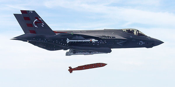
Screenshot from U.S. Navy video of a March 2016 test of an F-35 releasing the AGM-154 Joint Standoff Weapon (JSOW).
Raytheon Company and the U.S. Navy completed the final developmental test to integrate the Joint Standoff Weapon C onto the F-35 Joint Strike Fighter’s C variant, keeping the low-cost, air-to-ground missile on track for full deployment in 2019.
The JSOW glide weapon uses a GPS-inertial navigation system with an imaging infrared seeker that can identify and track targets autonomously. JSOW C weighs 1,000 pounds and is effective against high-value land targets at ranges greater than 70 nautical miles, day or night, and in adverse weather conditions.
“With JSOW C in its internal weapons bay, the Navy’s F-35C can now eliminate the toughest ground targets from significant standoff ranges,” said Mike Jarrett, vice president of Raytheon Air Warfare Systems. “JSOW’s advanced warhead and smart fuse provide fighter pilots with plenty of flexibility against hard and soft targets — plus, it has many programmable effects.”
Lockheed Martin, manufacturer of the F-35, and the F-35 Joint Program Office participated in the latest test, which took place on the Navy’s China Lake ranges in California.
Lockheed Martin has submitted a competitive and fully compliant proposal for the U.S. Air Force’s GPS III Follow On (GPS IIIF) program, which will add enhanced capabilities to the most advanced GPS satellites ever designed. The GPS IIIF program intends to produce up to 22 next-generation satellites.
The U.S. Air Force’s first 10 GPS III satellites, now in full production at Lockheed Martin, are already the most powerful GPS satellites ever designed. GPS III will have three times better accuracy and up to eight times improved anti-jamming capabilities. Spacecraft life will extend to 15 years, 25 percent longer than the newest GPS satellites on-orbit today. GPS III’s new L1C civil signal also will make it the first GPS satellite to be interoperable with other international global navigation satellite systems, like Galileo.
Lockheed Martin’s proposal for the GPS IIIF program adds further power, resiliency and capabilities to GPS III.
The biggest feature of GPS IIIF will be a regional military protection capability, which will increase anti-jam support in theater to ensure U.S. and allied forces cannot be denied access to GPS in hostile environments.
Lockheed Martin’s GPS IIIF will feature a fully-digital navigation payload. The payload on the first 10 GPS III satellites is already 70 percent digital.
Each GPS IIIF satellite will include a laser retro-reflector array, which allows the positioning of on-orbit satellites to be refined with ground-based, laser precision. The precise positioning of each satellite ultimately enhances the positioning signals they generate.
Additionally, the U.S. government will provide each GPS IIIF with a new search-and-rescue payload. These hosted payloads, spread around the globe on GPS IIIF satellites, will make it easier for first responders to detect and respond to emergency signals.
“When we developed our design for the first 10 GPS III, we used a flexible, modular architecture that would allow for the insertion of modern technologies and new Air Force requirements in a low-risk manner,” said Johnathon Caldwell, program manager for Lockheed Martin’s navigation systems mission area. “In addition, our GPS IIIF solution is based off a design already proven compatible with both the Air Force’s next generation Operational Control System (OCX) and the existing GPS constellation.”
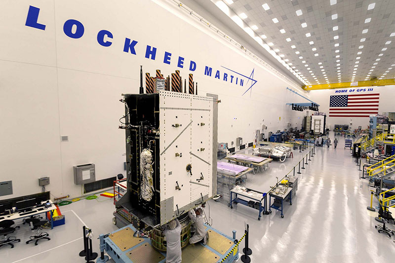
The first 10 GPS III satellites are in full production at Lockheed Martin’s GPS III Processing Facility, a $128 million cleanroom factory designed in a virtual reality environment to drive efficiency and reduce costs in satellite production.
GPS III SV02 completed rigorous Thermal Vacuum (TVAC) testing in December 2017, is in final environmental testing, and is expected to be declared AFL in summer 2018. GPS III SV03 was fully integrated in fall 2017 and recently began TVAC, and SV04 was recently integrated in anticipation of environmental testing later this summer. GPS III SV05 has now received its navigation payload and is in final vehicle build up. Not far behind, GPS III SV06 has begun its initial build with GPS III SV07 also planned to begin production this spring.
To date, more than 90 percent of parts and materials for all 10 satellites have been received, from more than 250 aerospace companies from 29 states, to help ensure GPS III maintains the gold standard in position, navigation and timing.