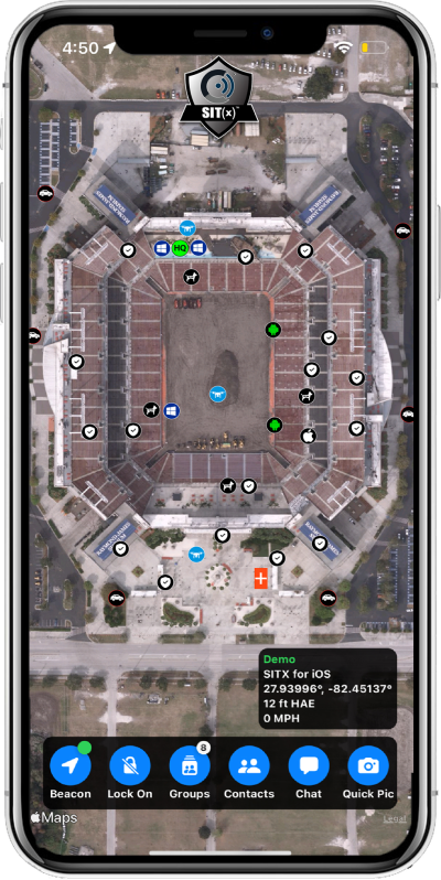
Sit(x) running on an iPhone. (Photo: PAR Government))
PAR Government, a provider of geospatial and decision support solutions for 57 years, has rebranded its TeamConnect cloud-based situational awareness suite as Sit(x). The commercial Sit(x) solution is designed for enhanced collaboration among government and civilian public safety organizations. PAR Government Systems Corporation (PGSC) is a wholly owned subsidiary of PAR Technology Corporation.
The Sit(x) solution enables individuals and teams to communicate directly by text or symbology and share real-time full-motion video (FMV), geographic information system (GIS) layers, imagery, GPS-derived locations, raster maps, photos and documents.
To complement the Android and Windows support already available in Sit(x), PAR is offering a free iOS app, giving Apple smartphone users access to the technology.
“The Sit(x) name better reflects the ability to provide effective situational awareness for any situation,” said Mark Kozak, PAR Government vice president of Product Innovation. “This results in faster, more informed decision making at the command level and in the field.”
Sit(x) is a TAK server-as-a-service solution based on the Team Awareness Kit (TAK) situational awareness technology that PAR Government developed for the U.S. defense and intelligence community under contract to the Department of Defense. This technology has been deployed under demanding conditions by every branch of the U.S. armed forces over the past decade.
PAR Government created the Sit(x) TAK server-as-a-Service offering specifically to enable real-time communication and information sharing between non-connected public safety personnel during rapidly evolving multi-jurisdictional situations, both planned and unexpected. These include large public gatherings, such as sports events or concerts, and emergency incidents related to terror attacks or natural disasters.
“Sit(x) can save lives, time, and resources by federating unrelated police and fire departments, U.S. government agencies, volunteer search-and-rescue groups, and even private security firms to collaborate as one coordinated entity during a major event,” Kozak said. “Due to its TAK lineage, Sit(x) opens the lines of communications between civilian public safety and the U.S. military, as well as our allies, with no export restrictions.”
The PAR Government Sit(x) offering is a subscription to the Sit(x) TAK Server-as-a-Service software suite in the cloud. Ready in minutes, Sit(x) scales to handle teams of any size and is protected with end-to-end secure connectivity. The suite provides complete lifecycle management – event preparation, rehearsal, training, dynamic response, post-mission playback and analysis, and new response simulation.
The investment by subscribing agencies is minimal because there is no computer hardware to purchase, and the end-user applications are available from the Google Play Store or Apple App Store for free. All server operations and software maintenance are managed 24/7 in the cloud by PAR.
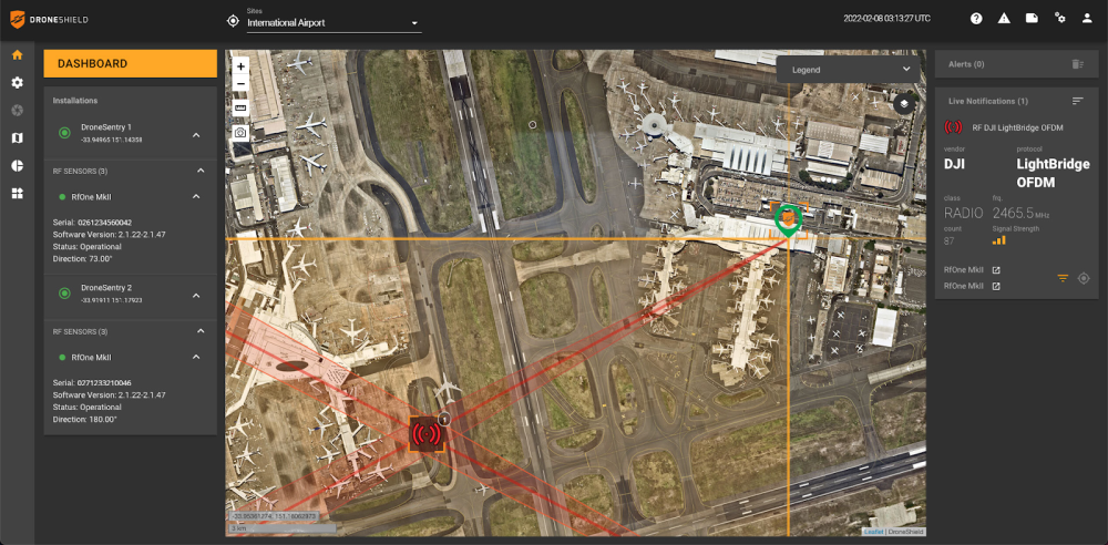
DroneSentry-C2 with Nearmap location data. (Screenshot: DroneShield)
DroneShield Limited, an Australian/U.S. global leader in artificial-intelligence-based platforms for protection against advanced threats such as drones and autonomous systems, has announced an enhanced version of its DroneSentry-C2 command-and-control software in partnership with location intelligence firm Nearmap.
Nearmap provides city-scale 3D content, artificial-intelligence data sets, geospatial tools, and high-resolution aerial imagery in Australia, New Zealand and North America.
DroneSentry-C2 provides an intuitive and feature-rich software platform, providing counter-UAS awareness and reporting capability. It integrates both DroneShield and third-party C-UAS sensors and effectors. Those include multiple AI-enabled sensing and tracking products, such as RfOne long-range direction-finding sensors for UAS detection and tracking, and camera-agnostic DroneOptID optical/thermal camera AI software.
DroneSentry-C2 will come with a standard mapping solution for cost-sensitive customers, and an optional Nearmap mapping upgrade for mapping data for markets requiring high performance, such as government, intelligence, Homeland Security and defense.
The software comes as an on-premises, air-gapped solution for intelligence, Homeland Security and defense users, or secure cloud for enterprise customers. The on-premises solution also includes a high-grade physical server. Both options come with regular mapping updates, including the ability for the user to load their own maps for sensitive locations.
“One of DroneShield’s differentiators is that we are both a sensor manufacturer and an integrator,” said Oleg Vornik, DroneShield CEO. “Providing a streamlined and standardized hardware / software bundle that gives our user community an easy-to-deploy and run command-and-control software will be critical as more fixed and pop-up site users seek to deploy counter-UAS products. Importantly, the offering is already validated by deployments such as U.S. Air Force and Australian Army, among a number of other tier 1 end users globally.”
A roundup of recent products in the GNSS and inertial positioning industry from the March 2022 issue of GPS World magazine.
OEM
Correction Service
Achieves RTK-level accuracy
Photo: Hexagon
“RTK From the Sky” technology has been integrated into the core of the TerraStar-C PRO corrections service. As a result, TerraStar-C PRO provides centimeter-level accuracy, not just in open-sky environments but also across challenging conditions created by buildings and foliage. TerraStar-C PRO now converges in less than three minutes by utilizing quad-band receiver and antenna technology to leverage modernized BeiDou 3, GPS III and Galileo E6 signals. The resulting process generates state-of-the-art corrections for all GNSS frequencies. The service improvements are accessible through the 7.08.10 firmware release for users of OEM7700, OEM719 and OEM729 cards and their associated enclosures for land and air applications.
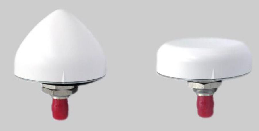
A north orientation mark is being added to the TW3000 family of Accutenna precision antennas and the TW5000 family of smart antennas. The new feature allows customers to align their antennas, standardize radiation patterns, and increase the synchronicity of their azimuth gain readings across multiple devices. The new north mark design has been thoroughly tested to ensure it conforms to or exceeds customer expectations and maintains each antenna’s stringent IP69K rating.
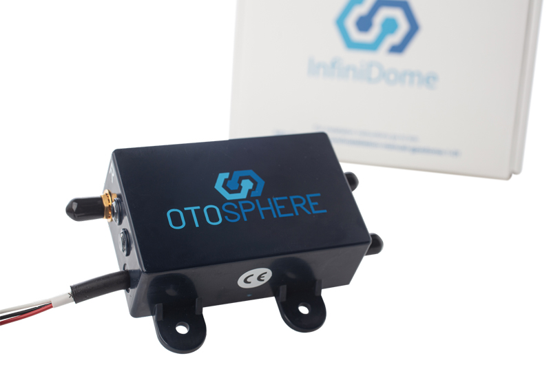
OtoSphere is a small, add-on module to the ViaLite GPS RF over fiber link and any GNSS-based system, providing GNSS protection against GPS jamming attacks, making any receiver more resilient. It ensures continuity of timing and navigation capability and enables normal operation during a jamming attack. According to ViaLite, no other solution that offers such protection is as small, light, affordable, or easy to install. The Otosphere protection module adds resilience to critical GPS timing services.Using OtoSphere, GPS receivers are up to 50 times more resilient to jamming attacks on positioning, navigation and timing (PNT) systems compared with having no protection. The GPS receiver can continue working normally throughout the attack. Timing-critical infrastructures in areas such as defense and cybersecurity can now be protected from these attacks. The Otosphere has a unique interference filtering algorithm that combines patterns from two external omnidirectional antennas that pinpoints the direction of the attack, then directs a null toward the unwanted signal to reject and reduce disruptions.
Infrastructure system for autonomous transportation
Photo: Seoul Robotics
The Level 5 Control Tower (LV5 CTRL TWR)) is a mesh network of sensors and computers on infrastructure that guides vehicles autonomously without requiring that sensors be placed on individual vehicles. The technology is automating last-mile fleet logistics at BMW’s manufacturing facility in Munich. The system has the potential to transform operations for a wide range of business applications, from vehicle distribution centers to car rental companies and trucking logistics.
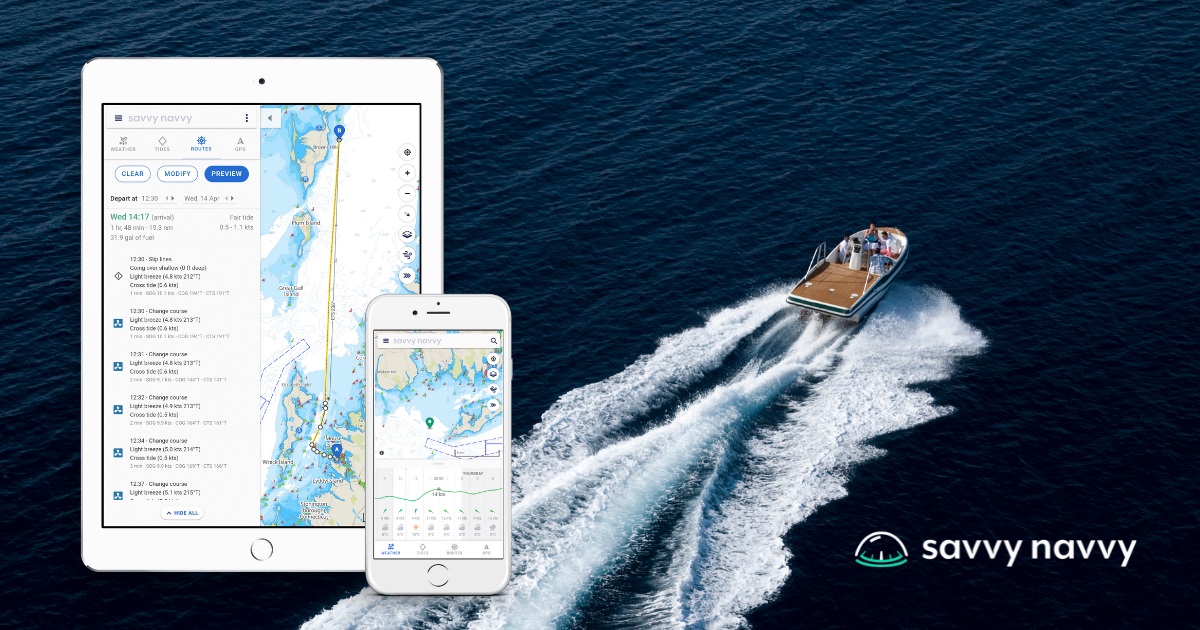
Savvy Navvy provides essential marine information, allowing boaters to cross-check their traditional navigation plans. It integrates plotting charts, weather and tide data, marina details and passage planning into one app. The app reduces the risk of human error as well as the stress of voyage preparation. It is used by boaters in more than 100 countries around the world, with more than 43 million miles plotted. It works on phones or tablets using Android, IOS, PC or Mac.
The Pix4D viDoc RTK handheld rover attaches to iOS devices to bring RTK accuracy to terrestrial scanning on iPhones and iPads. When paired with the PIX4Dcatch mobile app, the viDoc rover can replace survey tools such as RTK GNSS rovers and terrestrial scanners, the company said. The two products create a workflow that turns iPhones or iPads into an accurate terrestrial scanning device, with centimeter-accurate RTK positioning from an existing NTRIP network. The tools can be used to 3D model small areas or structures.
Bad Elf now provides an integrated laser-offset workflow for acquiring high-accuracy field data in GNSS-challenged environments using Esri ArcGIS Field Maps for Android, as well as iOS. The workflow integrates Bad Elf and Laser Tech (LTI) hardware in collaboration with ArcGIS technology from Esri. The Bad Elf Flex connects to any LTI TruPulse rangefinder over a wired or Bluetooth connection to deliver high-accuracy location data to Esri ArcGIS Field Maps. Mobile workers can efficiently complete position and height data collection in access-limited situations, saving time, money and effort.
A free global map created from processed satellite imagery is available. To create the world image, satellite imagery was processed to remove clouds and balance shades and tones, and then carefully stitched together to create a seamless map layer with beautiful colors. The input data is recent, from 2020 and 2021, and rendered as one tiled file with 13 zoom levels 0-13 for use in web applications. It is a viable, up-to-date alternative to Google maps for software developers, without privacy issues.
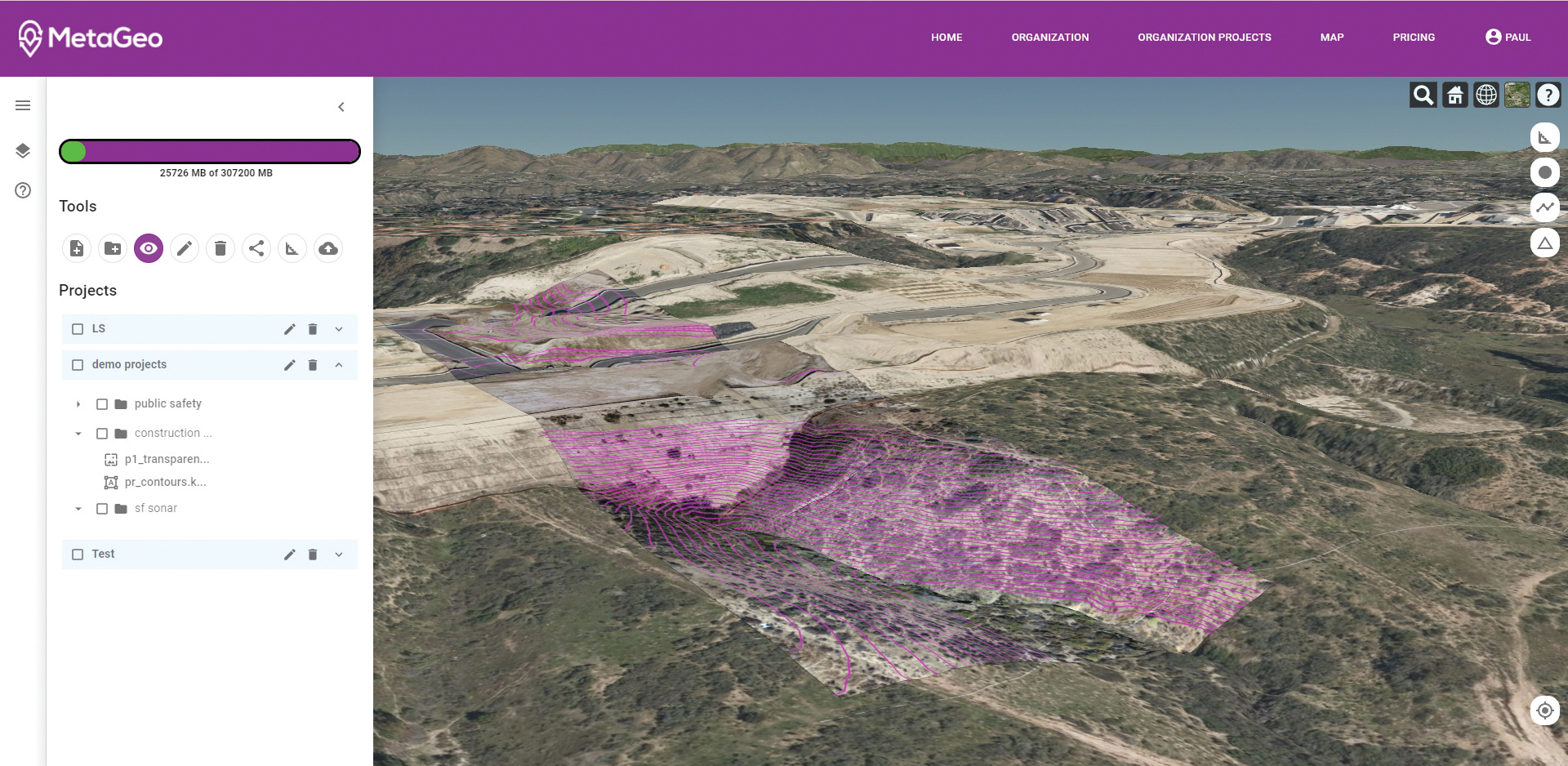
The MetaGeo geographic information system (GIS) platform enables organizations of all sizes to host, analyze, find and share 3D map datasets among any internet-capable devices. The platform processes location-based map or sensor data from the real world, combines it into a single 3D virtual environment, and streams it to any device or mapping platform. The affordable and easy-to-use platform can load data from multiple sources: satellites, drones, mobile devices, public and crowdsourced repositories, internet of things (IoT) sensor data, 3D models and topographic maps. The data is then processed by the MetaGeo platform into a 3D world and streamed to any internet-connected device, enabling live collaboration between the office and field via mobile or augmented reality device. A plug-in software development kit (SDK) allows for third-party tools to scale and fit user needs.
Trimble has launched the Trimble AP+ Land GNSS-inertial OEM platform for accurate and robust position and orientation for georeferencing sensors and positioning vehicles in land mobile-mapping applications. The platform enables users to accurately and efficiently track and monitor fleets and produce high-definition (HD) maps and 3D models. It can also serve as a reference solution for advanced driver-assistance systems (ADAS) testing, even in challenging GNSS environments. The comprehensive Trimble AP+ Land is small enough to integrate into compact mobile-mapping systems. It is compatible with virtually any type of mapping sensor, including single- or multi-lidar systems, video cameras, photogrammetric and panoramic cameras, and similar sensors.
Ronin 4D, a professional cinema camera from DJI, incorporates the full-frame Zenmuse X9 gimbal camera, active four-axis stabilization, lidar focusing, and wireless transmission. Firmware available at launch will allow the remote monitor to view and control the main monitor, interface with mirror control mode, and allow a clean video stream over HDMI and SDI ports on the Remote Monitor Expansion Plate with no overlaid information. It will also support automatic calibration for some third-party auto lenses to realize Lidar Focusing System functions.
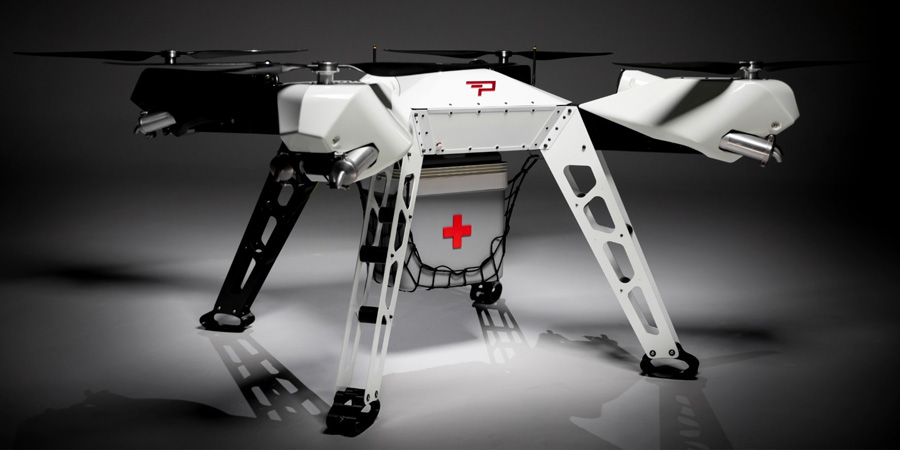
Parallel Hybrid Electric Multirotor (PHEM) drone technology improves flight time with a heavy payload, yielding increased efficiency and eliminating the large battery used in other hybrids. It has the potential to extend a UAV’s flight time from 15 minutes to well over an hour and drastically increase range. In the search-and-rescue field, a heavy-lift drone can enhance first responder capabilities by allowing for substantially quicker response times to remote locations. Other applications include military platforms, fighting wildfires, and medical and logistics missions.
A new software app helps local governments in the UK plan alternative routes, infrastructure and access that facilitate walking and cycling in cities, reducing traffic. XMAP, a cloud-based web geographic information system (GIS) for local governments from Geoxphere, now offers Isochrone. It provides a detailed and visual insight into existing transport infrastructure, assessing accessibility and the local environment to calculate and compare travel times by foot, cycle and car. The tool enables planners to understand how the existing infrastructure is enabling or restricting green journeys. It also helps them model and visualize how improvements to the transport network can be made and engage with communities to promote specific schemes and opportunities for active travel.
The XMAP Isochrone tool allows a user to create polygons on a map showing how far it is possible to drive, walk or cycle in a set amount of time. Using algorithms that take into consideration the actual road, foot path or cycle network, as well as historic speed data and average walking and cycling rates, it provides a more accurate methodology of calculating travel times compared to traditional concentric circles based on straight line distances.
XMAP is accessible from any web-enabled device, without plug-ins, bolt-ons or additional installations. It includes a suite of inbuilt workflows to support delivery of local government services such as planning, housing, waste and recycling, and street services. XMAP comes complete with more than 250 geospatial data layers, from a variety of government agencies, as well as a fully maintained Ordnance Survey map stack.
Provided as a Software as a Service (SaaS), XMAP allows users to create and share business-critical map data without the risks involved in using open-source silos of GIS or the high cost of traditional GIS solutions. XMAP gives access to Ordnance Survey mapping, aerial photography, together with third party and in-house datasets, for more than 1,700 government organizations as well as a range of commercial clients.
With Congressional approval of $17 billion in infrastructure funding, the largest single allocation ever, the scramble to win contracts is about to get red hot and AEC firms are gearing up. In this very competitive game, top engineering firms are relying on their experience, technology, business acumen and ability to execute.
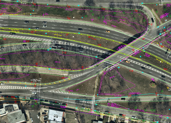
Advances in aerial mapping play a key role in how AEC firms pursue these contracts. Savvy firms have been using this technology for years. Rather than rely on lower resolution satellite imagery or local drone imagery, they use wide-area-coverage aerial maps to clearly display the detail needed to plan and execute.
Over the past decade, maps made using aerial photogrammetry have played an important role in the AEC space. Using high-performance cameras, fleets of planes capture hundreds of square miles per plane per day, provided that the weather is clear. The imagery is processed and made available to engineering companies within days of capture, allowing them to see very clear imagery.
AEC organizations use different forms of aerial maps to evaluate sites, improve their survey designs, and build and maintain infrastructure (roads, highways, bridges, tunnels, overpasses, rail, airports, housing, commercial building development, water resources, parks, pavement and more). Imagine you’re a state or local government that needs to build a bridge, or a developer who wants to contract with an engineering and construction firm to build affordable housing. Why travel to perform time-consuming site evaluations when you can meet with engineering teams in your office and review hundreds of potential sites instantly using current aerial photos that show change over time?
The engineering teams point out elevation changes, the presence and height of vegetation, neighboring communities, bodies of water, ponding and more. They easily navigate from one location to another as you discuss where the entrance to the community could be, how the road network might be configured, and the proximity to retail, schools and healthcare. Within minutes you measure risk, understand the landscape, make decisions, and begin to estimate the project costs. Your teams collaborate, discuss the pros and cons, measure distances and navigate across the terrain virtually.
Aerial mapping provides a competitive advantage for AEC companies to win their fair share of the infrastructure bill. It also gives governments and developers the confidence they need to make the right decisions. Typically, this involves looking at sites from all angles. The classic form of aerial mapping used by engineers is a top-down perspective. Increasingly, these organizations have used oblique imagery captured at an angled perspective, which shows height.
Artificial Intelligence and Aerial Photography
Starting a few years ago, 3D imagery and digital surface models began to allow engineers to navigate through the imagery and query it based on elevation. More recently, aerial mapping has leveraged artificial intelligence (AI) to classify properties and the landscape. Do you need to see nearby construction sites? AI applied to aerial photography can do that automatically. This rich set of data includes attributes such as tree overhang, roof condition, roof material, building footprints, vegetation height, surface material, swimming pools and even solar panels.
The blend of all these imagery types and AI into a single solution makes everything discoverable. Users can search by address, city, location or point of interest. They can visualize the imagery along with lat/long coordinates and quickly switch from top-down views to obliques to 3D. As they learn more about the landscape, they begin to turn on AI attributes, gaining deeper insights.
Sometimes, the analyses go even further. Engineering organizations export the imagery to tools of their choice from such companies as Autodesk, Esri or Bentley Systems, use field-collected ground control points to ensure that it is survey grade, then use it as a base layer for their designs. They even create marketing presentations and video content to help them win the business. Current high-resolution aerial maps have become a cornerstone of how these organizations operate.
This approach provides unique advantages for engineering firms. For example, they can combine geospatial and construction datasets in a common operating environment to reduce complexity, streamline communication, ensure that all stakeholders are up to date, and check their progress toward meeting contractual obligations.
Planners have current, contextual designs and models to make accurate decisions about planning and development activities. They can view asset locations and conditions to facilitate maintenance and upgrades, leverage aerial maps inside other platforms to improve work orders and reduce field visits, and ensure regulatory compliance.
Whether it’s improving highway safety, constructing ferry terminals, improving transportation systems, developing land or building a network of recreational trails, aerial imagery provides engineering and construction companies with a competitive advantage to win new business, improve client satisfaction and meet growth targets. With $17 billion on the line, sophisticated firms are finding a way to secure their fair share of the pie.
Combined geospatial solutions improve operations using location intelligence and mapping
Locana and Bent Ear Solutions are collaborating to provide location-based solutions that help customers improve their performance and decision-making across the organization, including their operations center. Locana was formerly known as Critigen.
The companies will work closely with clients and identify issues, challenges and mission priorities to modernize their geospatial capabilities and improve organizational effectiveness using location intelligence and mapping.
“Leveraging the complementary skills and expertise each company provides, clients gain tremendous value with focused and optimized technology, services, training, and support,” said Mike Eggenberger, VP, North America Sales, Locana. “Locana and Bent Ear Solutions understand the power of location for gaining an accurate understanding of circumstances and acting with clarity and precision.”
Bent Ear Solutions maintains deep domain expertise in operations, crisis management and business continuity. The organization has a track record of providing configured, situational awareness based on geographic information systems (GIS) combined with targeted workflows that support multiple requirements.
Locana has an extensive history of successfully designing and delivering robust, large-scale geospatial projects. Integrating business systems with scalable GIS, Locana helps clients spatially enable their enterprise with location analytics and high-powered mapping.
“Locana and Bent Ear Solutions are both dedicated to being a trusted partner for our clients,” said Chris McIntosh, CEO, Bent Ear Solutions. “We have a unique opportunity to combine our areas of excellence to address their complex challenges. We believe our collaborative approach will help them maximize the value and use of GIS across the enterprise.”
Locana and BES combined will deliver tailored GIS solutions and integration that organizations need to overcome system silos and enable situational awareness. The partnership will supply strategic and tactical planning, workflow development, team-building processes, documentation, procedural support and systematic training and exercises.
The result is long-term value in the form of access to sophisticated analysis and actionable intelligence, the companies said.
MetaGeo has launched a geographic information system (GIS) platform to enable organizations of all sizes to host, analyze, find and share 3D map datasets among any internet-capable devices.
The platform processes location-based map or sensor data from the real world, combines it into a single 3D virtual environment, and streams it to any device or mapping platform.
The affordable and easy-to-use platform can load data from multiple sources: satellites, drones, mobile devices, public and crowdsourced repositories, internet of things (IoT) sensor data, 3D models and topographic maps.
The data is then processed by the MetaGeo platform into a 3D world and streamed to any internet-connected device, enabling live collaboration between the office and field via mobile or AR device. A plug-in software development kit (SDK) allows for third-party tools to scale and fit user needs.
Applications include academia, architecture, engineering, construction, energy, natural resource management, environmental monitoring, utilities and public safety. Uses include planning and managing construction sites, organizing layouts of events, creating maps for public safety, and visualizing inspection imagery from drones and mobile devices.
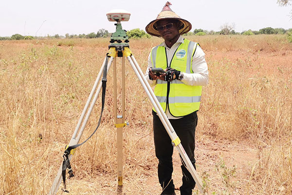
Surveyors used ComNav equipment to construct a hospital in Burkina Faso. (Photo: ComNav)
Line of sight to GNSS satellites is sometimes obscured by buildings and trees, which also cause multipath, as does nearby water. These conditions require an RTK receiver with multipath mitigation. Often, surveying must occur on property corners or on uneven ground, where it is hard to place surveying equipment. For these reasons, reliability and accuracy are essential, especially in harsh environments. Ground control points require 1-2mm accuracy and topo surveys 1-2cm accuracy. Surveying for AEC also requires software that processes digital files.
ComNav has focused on GNSS core technology innovation and applications for 10 years. The Quantum III technology includes algorithms to suppress multipath and supports all GNSS constellations, allowing the users to acquire and keep RTK centimeter accuracy even in harsh environments. The built-in tilt IMU will help where the exact location to be surveyed is hard to reach. For example, the T300 Plus and N Series GNSS receivers support a maximum pole tilt of 60° and keep the compensation accuracy within 2.5cm, making the field work more efficient, convenient and reliable.
With the Survey Master software’s stake-out points, users can import DXF or DWG files directly and the software can stake out the point, line and surface in CAD.
In April 2021, the government of Burkina Faso used ComNav GNSS T300Plus to provide ground control points survey for the construction of a hospital.
The land security and topographic surveying were completed within only six days, less than half the time that had been scheduled for those tasks. This greatly expedited the construction of the hospital and helped with the fight against infectious diseases, including COVID-19.
In recent years, the architecture, engineering and construction (AEC) industry has benefited greatly from growing GNSS accuracy, smaller laser scanners, UAVs, and more efficient management, collaboration and visualization software. We asked five companies operating in this space to address three questions:
What are the key challenges of surveying for the AEC industry today, compared with traditional boundary surveying and other types of surveying?
Which of your products are particularly relevant for this kind of surveying?
What was a recent AEC surveying success story?
In the following articles, five companies briefly describe their experience with the AEC industry:
Increasing urbanization is creating pressure to manage housing, utilities and infrastructure holistically. Hence the concept of digital twins. Digital twins enable the integrated operation and maintenance of any geospatial asset to meet the increased demand for efficient and intelligent transportation systems, the green expansion of urban areas and sustainable infrastructure.
Traditional GNSS or optical measurement instruments no longer suffice to capture all the necessary information in a timely manner and with the right levels of detail. Integrating technological advances — GNSS, inertial systems, lidar sensors and 360° spherical imagery — into a single mobile-mapping system has greatly increased the ability to produce complete 3D models with high accuracy and precision. Mobile mapping also directly reduces workload, lowers project costs, simplifies data use, and provides reality-based design.
Mobile mapping surveys have been proven to be four to 10 times faster and three to seven times less expensive than traditional methods, delivering the required results up to three times faster. Integrated, multi-platform mobile-mapping solutions bridge the gap between the real world and the digital world for greater interoperability and accessibility of data in near real-time.
The high-accuracy and cross-platform design of CHC Navigation’s AlphaUni 900 lidar system provides an innovative solution for 3D spatio-temporal data acquisition, which is necessary for the digital transformation of the AEC industry.
Smart Cities
After developing for more than a decade, digital-twin technology is now a complex and comprehensive technical system to support the construction of new smart cities. It is an advanced model for the continuous innovation of urban development and a future form of modernization combining the virtual and real worlds. The creation of digital-twin cities brings to the forefront high-level topographic tools capable of providing comprehensive, multi-dimensional, large-scale, high-resolution data sets.
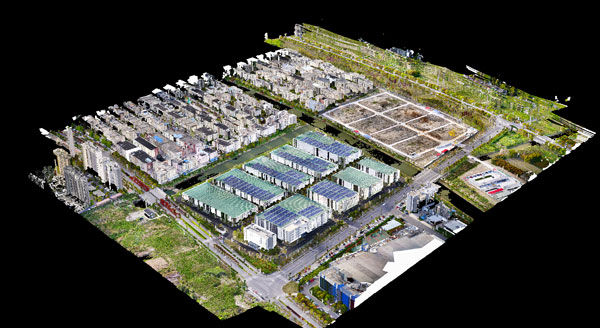
To illustrate typical digital-city projects, CHC Navigation conducted a proof-of-concept demonstration in the Jinshan District of Shanghai, which covers an area of about 600 square kilometers. This area has rich terrain features and characteristics typical of large modern cities, such as tall buildings, power lines, rivers and vegetation.
Versatile and easy-to-use platforms are essential for the democratization of lidar systems. Capturing 3D data with a single-platform lidar system can leave some areas blank in the point-cloud data. The AlphaUni900 lidar solution, with its multi-platform capability, can easily capture complete data from a UAV, car, backpack or unmanned surface vessel (USV) and provide a sophisticated and comprehensive 3D model. The AlphaUni 900 integrates seamlessly with real buildings, provides exterior and interior mapping, and dramatically changes the way high-precision data is collected.
The derived 3D models can be easily merged and correlated with social or economic spatial data, for example from building-integrated internet of things (IoT) and cloud computing data. As a result, complex operations can be optimized in real time, potential problems can be anticipated, and planned maintenance can be implemented to ensure the sustainability of urbanization projects over their entire lifespan, all in a fully connected model.
Affordable, user-friendly solutions for capturing and processing airborne lidar data and imagery have triggered a strong adoption of UAV technology in the AEC industry. For CHC Navigation, 2021 was marked by the huge success of the AlphaAir 450, a breakthrough in 3D UAV mapping technology. With its ease of use, high accuracy and affordability, the AA450 expands the scope of lidar surveying to non-professional users in geospatial reality-capture applications and to those who have never been able to afford such technology before.
While some tasks for AEC surveying are similar to other types of surveying — such as original ground surveying, creating site control and live monitoring — the biggest differences and challenges arise in data management, timeframes, communication and deliverables.
In AEC surveying, the project timeline is the primary factor driving everything, creating a different kind of pressure on the surveyor. As data experts and problem solvers, surveyors for AEC must quickly adapt to construction progress, as their survey knowledge can be needed on site at any point.
Information transfer challenges also exist — such as clearly communicating data to non-surveyors who perform measurement tasks — along with creating unique deliverables across construction stages. These include 3D terrain models with real-world coordinates for architects; fit-for-purpose computer-aided design and Industry Foundation Class models for machine operators and mechanical, electrical and plumbing installers or off-site fabricators; and progress reports for project owners.
Several AEC firms have opted to create their own inhouse survey teams. This allows greater control over the consistency and clarity in communication and deliverables, because they focus exclusively on surveying for AEC and are therefore familiar with its specific challenges.
The main challenge for the surveyor in AEC is sifting through and processing the data, assessing quality, understanding relevance, producing results and crafting deliverables to meet the clients’ needs.
An integrated total solution is important for AEC surveyors who must decide not only which technology to use, but how to process data from different technologies together. Our products fit within this integrated solution concept.
Leica Geosystems‘ automated total stations, multistations and GNSS blend innovation and traditional technology, such as the Leica GS18 I with tilt and visual positioning, enabling surveyors to measure more, faster.
For mass data collection, the Leica RTC360 3D laser scanner operates at two million points per second and contains visual inertial system (VIS) technology simplifying the registration process. The Leica BLK series combines intelligence and accessibility, including the BLK360 imaging laser scanner, the handheld BLK2GO, and the latest autonomous technology of the BLK2FLY and BLKARC.
Finally, our software connects surveyors to their sensors and data in the field with Leica Captivate and Leica Cyclone Field 360 and to the office with Leica Infinity and Leica Cyclone, extending to existing CAD software with the Leica CloudWorx suite of CAD plug-ins.
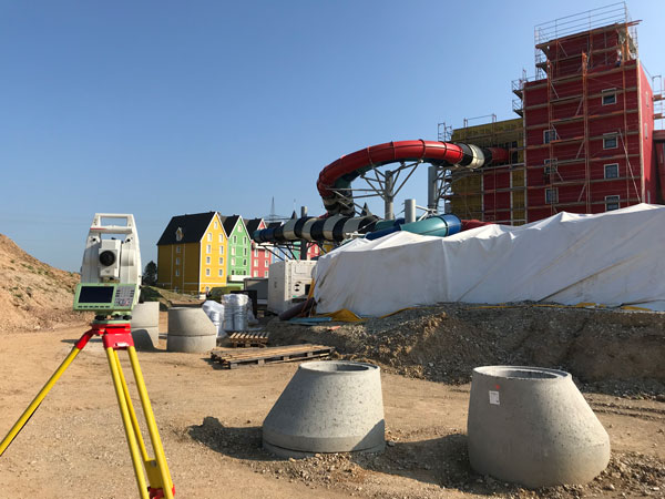
Bringing an Aqua Park to Life
One memorable success story was the use of our products for AEC survey tasks during construction of Germany’s biggest aqua park, Rulantica. The survey work was led by Saladin Keller of Keller planen + bauen. The project involved the creation and construction of a Nordic-themed water world featuring 25 attractions, including water slides, a wave pool and a lazy river.
Alongside all the typical surveying for AEC tasks — establishing site control, staking out pipes, and planning and staking the entire traffic infrastructure — Keller had the challenge of measuring and positioning the complex internal geometry. These tasks required skilled surveyors and a variety of survey tools, such as total stations, GNSS rovers, laser scanners and powerful processing software.
Operating within the AEC environment also meant that communication and flexibility were key to the success of the project. Keller needed to provide the right data to different trades and handle urgent maintenance requests requiring surveying skill, such as rebuilding parts and adjusting utilities.
Nearmap aerial imagery is used as a basis for survey linework. Photo: Nearmap
With Congressional approval of $17 billion in infrastructure funding, the largest single allocation ever, the scramble to win contracts is about to get red hot and AEC firms are gearing up. In this very competitive game, top engineering firms are relying on their experience, technology, business acumen and ability to execute.
Advances in aerial mapping play a key role in how AEC firms pursue these contracts. Savvy firms have been using this technology for years. Rather than rely on lower resolution satellite imagery or local drone imagery, they use wide-area-coverage aerial maps to clearly display the detail needed to plan and execute.
Over the past decade, maps made using aerial photogrammetry have played an important role in the AEC space. Using high-performance cameras, fleets of planes capture hundreds of square miles per plane per day, provided that the weather is clear. The imagery is processed and made available to engineering companies within days of capture, allowing them to see very clear imagery.
AEC organizations use different forms of aerial maps to evaluate sites, improve their survey designs, and build and maintain infrastructure (roads, highways, bridges, tunnels, overpasses, rail, airports, housing, commercial building development, water resources, parks, pavement and more). Imagine you’re a state or local government that needs to build a bridge, or a developer who wants to contract with an engineering and construction firm to build affordable housing. Why travel to perform time-consuming site evaluations when you can meet with engineering teams in your office and review hundreds of potential sites instantly using current aerial photos that show change over time?
The engineering teams point out elevation changes, the presence and height of vegetation, neighboring communities, bodies of water, ponding and more. They easily navigate from one location to another as you discuss where the entrance to the community could be, how the road network might be configured, and the proximity to retail, schools and healthcare. Within minutes you measure risk, understand the landscape, make decisions, and begin to estimate the project costs. Your teams collaborate, discuss the pros and cons, measure distances and navigate across the terrain virtually.
Aerial mapping provides a competitive advantage for AEC companies to win their fair share of the infrastructure bill. It also gives governments and developers the confidence they need to make the right decisions. Typically, this involves looking at sites from all angles. The classic form of aerial mapping used by engineers is a top-down perspective. Increasingly, these organizations have used oblique imagery captured at an angled perspective, which shows height.
Artificial Intelligence and Aerial Photography
Starting a few years ago, 3D imagery and digital surface models began to allow engineers to navigate through the imagery and query it based on elevation. More recently, aerial mapping has leveraged artificial intelligence (AI) to classify properties and the landscape. Do you need to see nearby construction sites? AI applied to aerial photography can do that automatically. This rich set of data includes attributes such as tree overhang, roof condition, roof material, building footprints, vegetation height, surface material, swimming pools and even solar panels.
The blend of all these imagery types and AI into a single solution makes everything discoverable. Users can search by address, city, location or point of interest. They can visualize the imagery along with lat/long coordinates and quickly switch from top-down views to obliques to 3D. As they learn more about the landscape, they begin to turn on AI attributes, gaining deeper insights.
Sometimes, the analyses go even further. Engineering organizations export the imagery to tools of their choice from such companies as Autodesk, Esri or Bentley Systems, use field-collected ground control points to ensure that it is survey grade, then use it as a base layer for their designs. They even create marketing presentations and video content to help them win the business. Current high-resolution aerial maps have become a cornerstone of how these organizations operate.
This approach provides unique advantages for engineering firms. For example, they can combine geospatial and construction datasets in a common operating environment to reduce complexity, streamline communication, ensure that all stakeholders are up to date, and check their progress toward meeting contractual obligations.
Planners have current, contextual designs and models to make accurate decisions about planning and development activities. They can view asset locations and conditions to facilitate maintenance and upgrades, leverage aerial maps inside other platforms to improve work orders and reduce field visits, and ensure regulatory compliance.
Whether it’s improving highway safety, constructing ferry terminals, improving transportation systems, developing land or building a network of recreational trails, aerial imagery provides engineering and construction companies with a competitive advantage to win new business, improve client satisfaction and meet growth targets. With $17 billion on the line, sophisticated firms are finding a way to secure their fair share of the pie.