GPS and airborne light detection and ranging (lidar) have revolutionized archaeology. In just a little more than a decade, dozens of previously hidden cities and settlements have been discovered under heavy tree canopy and in other terrain. Many of the sites are in difficult-to-access areas, such as high atop mountains, in vast deserts, or enclosed in thick, nearly impenetrable foliage. Many were only the stuff of legend.
Others are right under our feet. In 2018, early settlements were uncovered in New England, including now-abandoned walls, roads and building foundations.
With the development of lidar, archaeologists gained perhaps their most powerful tool since carbon dating. Lidar began as a million-dollar classified technology. Now lidar units are small enough to attach to unmanned aerial vehicles (UAVs).
Lidar devices send more than 100,000 laser pulses to the ground every second and use their return times to calculate precise elevation data that allow researchers to build three-dimensional maps of a landscape, while GPS receivers provide its coordinates. Lidar fly-overs have revealed ancient cities, temples, causeways, irrigation systems and other structures, which are then ground-truthed by excavation teams.
“Lidar has completely changed the way we survey ancient Maya cities and what we can know about them, and it is a thousand times better than [what we used] before,” Francisco Estrada-Belli told GPS World. Estrada-Belli is a research professor at Tulane University’s Middle American Research Institute.
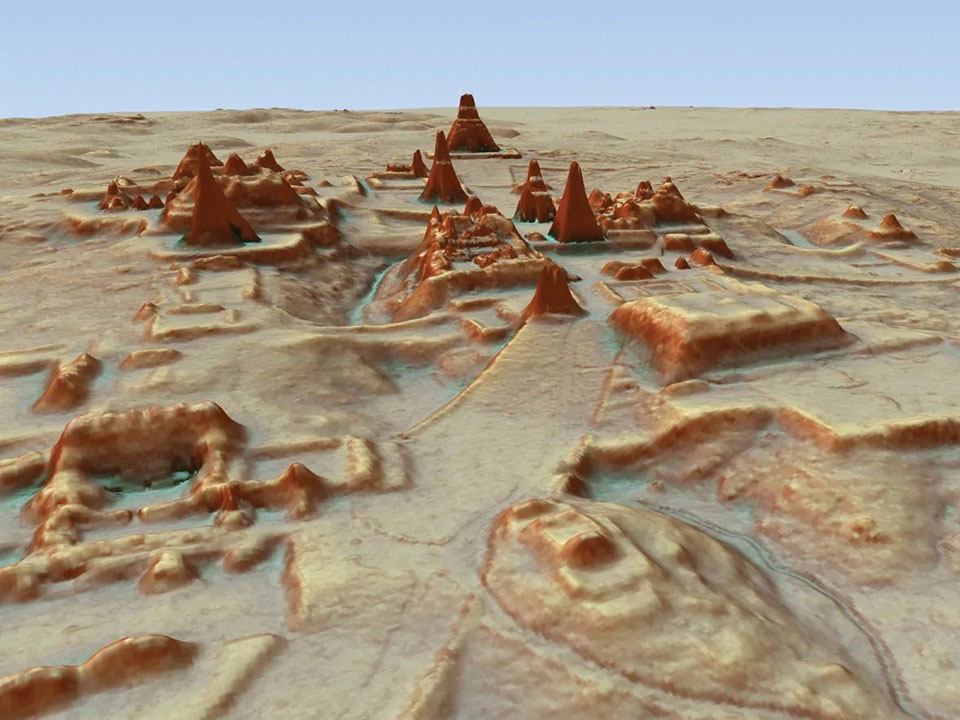
The application of lidar to archaeology began in 2009, when NASA sponsored a remote-sensing project that showed lidar’s usefulness below the forest canopy. The project revealed the surprisingly vast scope of Caracol, the largest Mayan archaeological site in Belize. Urban Caracol maintained a population of more than 100,000 people with an immense agricultural field system and elaborate city planning.
Since then, lidar has been used the world over to uncover buried secrets from early Roman fortifications in Italy to landscape changes from World War I. Just this August, lidar unearthed sobering evidence of a massacre by Nazi Germany in Poland during World War II.
Image: F. Estada-Belli/Pacunam Lidar InitiativePhoto:
A landmark project in Guatemala illustrates the benefits of lidar. The ancient city of Tikal was one of the best-mapped regions of the Mayan world, but the Pacunam Lidar Initiative quintupled the amount of mapping done in 50 years in a single summer, with 61,000 structures found in an 810-square-mile area invisible to the naked eye because of overgrown vegetation. What experts had mistaken for unusable swampland, for instance, had actually been farmland, crisscrossed with canals. The area may have been home to a population of up to 10 million people. Results were published in Science in 2018.
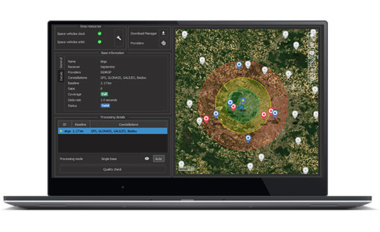
Septentrio now offers Qinertia post-processing software from SBG Systems on AsteRx-i3 D Pro+, AsteRx-i3 S Pro+ and AsteRx SBi3 Pro+ receivers
Septentrio will now offer post-processing solutions for its GNSS/INS (inertial navigation system) receivers, using SBG Systems’ Qinertia software.
The AsteRx-i3 Pro+ receivers are fully compatible with Qinertia post-processing software, so no data manipulation is required before the post-processing step.
Land or aerial mapping applications, which do not have access to real-time GNSS corrections, benefit from post-processing software for higher positioning and orientation (heading, pitch and roll) accuracy. With the addition of post-processing, Septentrio GNSS/INS products cover the full mapping workflow.
“As a result of our cooperation with SBG Systems, Septentrio’s mapping customers who use GNSS/INS are benefiting from a quicker and more reliable workflow,” said Danilo Sabbatini, product manager at Septentrio. “The intuitive user interface of Qinertia software makes it easy for users to further improve their positioning and orientation accuracy in the post-processing step.”
In case of GNSS outage or correction link failure, post-processing recovers accuracy for recorded positioning and inertial data.
After the mission, Qinertia gives access to real-time kinematic (RTK) corrections from more than 8,000 base stations to deliver centimeter level accuracy. Trajectory and orientation are greatly improved by post processing GNSS and IMU data forward and backward. The Qinertia GNSS/INS post-processed kinematic (PPK) solution provides accuracy, reliability, advanced quality-control indicators, and a modern application programming interface (API).
Qinertia recently added an image geotagging feature, and specific outputs dedicated to photogrammetry.
Qinertia post-processing software will be used on Septentrio receivers. (Photo: SBG Systems)
A roundup of recent products in the GNSS and inertial positioning industry from the September 2021 issue of GPS World magazine.
OEM
Network Expansion
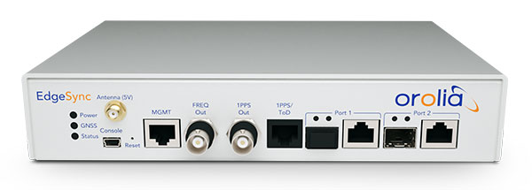
Provides precision timing over fiber
Photo: Huber+Suhner
Direct GPS-over-Fiber is a copper-free GNSS remote antenna that eliminates the need for costly power infrastructure. It uses power-over-fiber technology to distribute both the timing signal and power for the remote device. It is designed for telecommunication and data-center customers in need of scalable timing infrastructure solutions for outdoor remote antenna applications. It is fast and easy to install, with flexible, space-saving configurations that eliminate the need for power infrastructure at the remote end. The product makes network expansion achievable with a compact design and integrated transmitters, eliminating the need for multiple GPS antennas and maximizing the available space. It also extends the signal range between the antenna and the receiver.
The cost-effective EdgeSync network timing platform provides NTP and PTP grandmaster and boundary clock functionality for real-time edge applications. High performance, scalability, ease of use and manageability make EdgeSync suitable for data centers, finance, mobile edge computing, enterprise, smart grid, industrial IoT, process control and telecommunications. EdgeSync uses a multi-GNSS receiver (GPS, Galileo, GLONASS, BeiDou and QZSS), PTP and Synchronous Ethernet as input references and generates PTP, SyncE, NTP and timing signals (10 MHz, 1 PPS and Time of Day message) as outputs. It also can provide IEEE 1588-2008 (PTP) grandmaster and boundary clock functionality and leverages unique PTP algorithms to deliver stringent timing for demanding, precise applications.
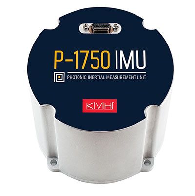
The P-1750 IMU and the P-1725 IMU complement the previously released P-1775 IMU to create a full line of IMUs with high-performance accelerometers and photonic integrated chip (PIC) technology. The P-series IMUs are offered in the same compact IMU housing design, and now offer more dynamic and accurate sensor performance, delivering improved navigation capability and more environmental robustness in vibration and shock capability for more challenging applications. PIC technology features an integrated planar optical chip that replaces individual fiber-optic components to simplify production and increase reliability. The accelerometers used in the P-series IMUs offer greater sensitivity and accuracy in their dynamic ranges. The IMUs are designed for challenging applications on land, sea and air, including autonomous trucks and people movers, drones, autonomous underwater vehicles and platform stabilization. Industries include transportation, military, agriculture, construction and mining.
The HC860 and HC860E active GNSS/Iridium antennas are designed for precise positioning, covering the GPS/QZSS-L1/L2, GLONASS-G1/G2, Galileo-E1 and BeiDou-B1 bands, including regional SBAS. The antennas also support active Iridium reception in the 1616.0-1626.5 MHz band. The HC860 housed and HC860E embedded helical antennas are designed for high-accuracy positioning. They are packaged in a light, compact form factor suitable for a variety of applications, including autonomous vehicle navigation (land, sea and air), handheld survey devices, automotive positioning, timing and other precise-positioning applications.
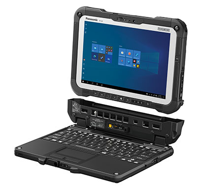
The Panasonic Toughbook G2 is a fully rugged 2-in-1 detachable tablet with optional keyboard that features an innovative modular design and user-removable expansion packs (xPAKs). With three modular expansion areas and up to 36 xPAK combinations, users can customize the Toughbook G2 to suit their needs with options including a 4G LTE-A multi-carrier with GPS or a dedicated U-blox NEO M8N receiver. The device is backward compatible with most Toughbook 20 and G1 docks. It has a 10.1-inch display, an Intel Core i5 and i7 vPro processor and runs on Windows 10 Pro. It has an 18.5-hour battery life. The 2-in-1 detachable design allows users to operate the device both in laptop and tablet modes.
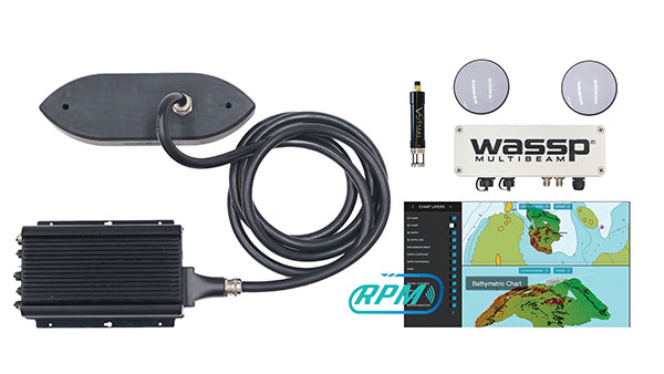
The WASSP S3r multibeam sounder combines data from a multibeam sounder transducer with 224 beams covering a 120° swath port to starboard along with position, heading and motion to create an accurate survey situations and environmental conditions. WASSP S3r is able to survey areas up to 10 times faster than a single-beam sounder. The S3r uses an SBG Ellipse-D Inertial Navigation System for its RTK + INS. The Ellipse-D allows the sounder to create accurately positioned 3D bathymetric representations of the seafloor, down to centimeter accuracy with minimal passes. WASSP has also incorporated the Ellipse-D into its S3Pr portable survey package. The SBG Ellipse-D was able to fit into a covered housing that allows quick setup on small vessels and interface with the WASSP DRX processing unit and CDX software. Ellipse-D integrates a dual-antenna, multi-band GNSS receiver, and is capable of delivering precise heading as well as centimeter-level position accuracy in challenging GNSS conditions.
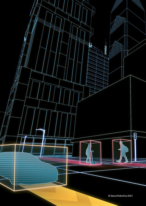
Voyage is a plug-and-play lidar perception system that delivers highly accurate object detection, tracking and classification capabilities. The deployment kit is equipped with SENSR2 software, lidar sensors and a lidar processing unit. Voyage provides volumetric profiling and motion-prediction capabilities, regardless of lighting conditions, and can collect and process data from up to four sensors for insights across the sensor coverage zones. Voyage does not capture, show or store any biometric and otherwise identifying data to maximize the protection of people’s privacy when installed as part of smart-city and security systems. The company’s sensor-agnostic perception software is available worldwide and is deployed by top-tier organizations such as BMW, Mercedes-Benz, the Chattanooga Department of Transportation and Emart, among others.
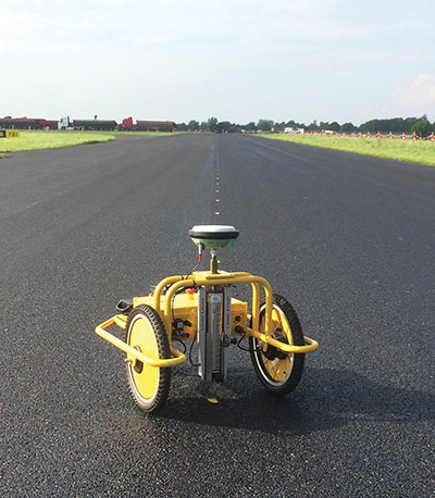
The TinySurveyor is a high-precision instrument for the surveying and infrastructure industries, able to execute large tasks up to 10 times faster than traditional methods. The machine pairs with a GNSS receiver to accomplish large-scale stake-outs, road pre-marking, as-built surveys and topographic surveys. Its ability to mark out existing data or collect new data at high speed and with high accuracy makes the TinySurveyor suitable for repetitive, time-consuming and labor-intensive tasks. With a GNSS receiver, repeatable results ensure accuracy of 1-2 cm. The TinySurveyor integrates with any GNSS receiver and has been tested with units from Topcon, Trimble and Leica.
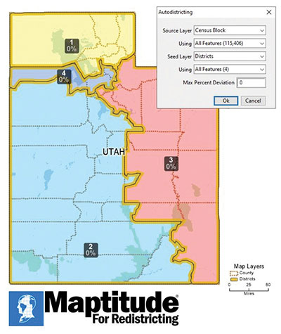
Maptitude for Redistricting 2021 is a specialized tool for political redistricting that enables state legislatures, political and public interest groups, local governments and private citizens to create and advocate redistricting plans that meet their goals, adhere to legal requirements, and stand up to public scrutiny and legal challenges. Unlike a general-purpose GIS, Maptitude for Redistricting streamlines the plan creation process for all types of political boundary definitions and provides all of the calculations and reports needed. It is suitable for congressional redistricting as well as state legislative districts, city councils and local school board districts.
With the Luciad 2021 platform, defense, aviation, maritime and other organizations can develop effective and reliable web applications. LuciadFusion, an all-in-one server solution for geospatial data management, has two new types of data streaming, resulting in faster streaming of imagery and point cloud data. LuciadRIA supports Web Assembly to bring desktop-like calculations to the browser. Luciad 2021 also features enhancements to software development kits for desktop and on-board vehicle applications. LuciadLightspeed seamlessly integrates into JavaFX-based applications, making it easier to embed its map components into user interfaces, and now provides for high-resolution map printing. LuciadCPillar, an API for C++ and C# developers, was updated with labeling support and other new features.
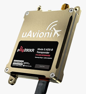
The Ping200XR integrates the capability of the Ping200X TSO Certified Mode S ADS-B OUT transponder with the high-integrity truFYX TSO-certified GPS position source into a single enclosure. The integration simplifies installation and allows the customer to choose between the installed GPS antenna or one provided with the Ping200XR. The integrated GPS ensures maximum safety by providing Source Integrity Level (SIL) 3 RTCA DO-229D and TSO-C145e Class Beta 1 performance, a requirement for Mode S and ADS-B airspace access, and for reception and processing by certified avionics and traffic collision avoidance systems in other aircraft as well as air traffic control. SIL 3 performance is not available from non-aviation certified GPS receivers, which often are used as an autopilot navigation source.
The RTL-450 lidar sensor incorporates a lightweight MEMS mirror and a precision navigation system to generate accurate data for demanding aerial surveying missions. The high-resolution, three-dimensional point clouds it creates enables operators to conduct advanced analytics of geographic and manmade features. Made in the United States, the RTL-450 incorporates patented lidar sensor technology. It weighs just over 4 pounds and is designed to operate independently of a drone platform, providing great flexibility for drone integration. Its modular design facilitates quick, efficient integration onto user-selected platforms.
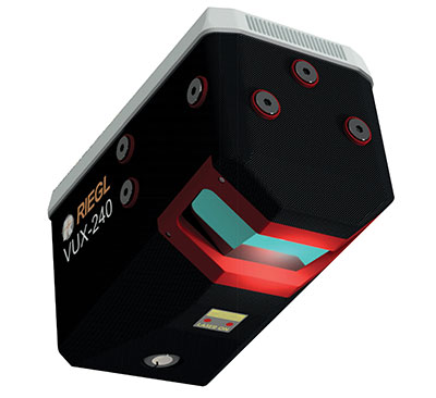
The RIEGL VUX-240 is a lightweight airborne laser scanner, especially designed for use on UAS/UAV/RPAS and small manned airplanes or helicopters. With its wide field of view of 75° and a data acquisition rate of up to 1.8 MHz, the instrument is suitable for high-point-density corridor mapping applications. The VUX-240 uses Riegl’s Waveform-Lidar technology, allowing echo digitization and online waveform processing. Multi-target resolution is the basis for penetrating even dense foliage. A continuously rotating polygon mirror wheel enables scan speeds of up to 400 lines per second, for efficiently covering large areas when operated from fast UAVs or aircrafts. The scanner stores 1 terabyte of data internally and is equipped with interfaces for an external IMU/GNSS system to control up to four external cameras.
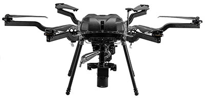
The Carrier H6 Hybrid is a heavy-lift gas-electric hybrid drone powered by either the H2400 (Carrier H6 HE+) or H5000 (Carrier H6 HL) hybrid drone generator. The Carrier H6 Hybrid HE+ is equipped with the H2400 generator providing 2400W of continuous power. The recommended payload is 4 kg allowing for up to 2.5 hours of flight. The maximum payload of 6 kg allows up to 1.5 hours of flight. The Carrier H6 Hybrid HL has a maximum payload capacity of 15 kg and can be configured to carry more robust scientific-grade sensors, such as multispectral cameras, professional DSLRs for cinematography and lidar. The H6 Hybrid HL also can be used in heavy-lift applications involving asset transportation and delivery, agricultural spraying and search and rescue.
Harris Aerial, harrisaerial.com
Industrial drone system
Autonomous ops from a dock
Photo: PowerVision
The PowerVision True Unmanned Aerial System combines the PowerEgg X 8K drone, PowerEgg Dock and the PowerVision Cloud web-based software platform. The integration provides a turnkey solution for remote, autonomous data-collection missions. With the system, drones can be deployed at scale as data-acquisition infrastructure, instead of tools to be operated on individual missions. Powered by artificial intelligence, the system streamlines the drone’s takeoff, flight, dynamic mission and return to the charging dock autonomously. The system weighs 34.8 pounds (15.8 kg) in a 570 x 400 x 250-millimeter form factor, allowing it to be deployed by a single person without special tools or equipment. The solution can be used for powerline inspections, environmental compliance, asset inspection, facility security, GIS, surveying and mapping.
The StarCourse service provides real-time extended ephemeris data for GNSS chipsets in connected mobile devices, giving them a headstart in determining position accurately and quickly. For devices with limited connectivity, typical extended ephemeris solutions have provided a headstart with 7¬–14 days of ephemeris data. StarCourse provides a 50% reduction in RAM requirements, 90% reduction in CPU cycles, and high location accuracy. Full data customization is provided to StarCourse subscribers, allowing them to create optimal solutions for their needs. The service enables autonomous positioning on connected GNSS IoT devices including asset tracking, wearables, in-dash navigation and mobile devices. For situations where accuracy is paramount, StarCourse Premium provides ultra-precise predicted ephemeris for the first 24 hours.
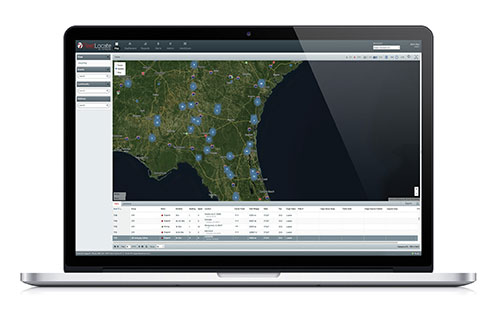
Trailer management solution FleetLocate captures data at the trailer level and translates it into actionable business intelligence to increase trailer productivity while reducing waste and costs. Telematics devices deliver core trailer insights that help automate yard checks and maximize use. Advanced trailer technologies are available, such as solar power management, tethered/untethered configurations, IntelliScan cargo sensing, cargo image capture and retrieval, door sensors, liftgate battery monitoring and more.
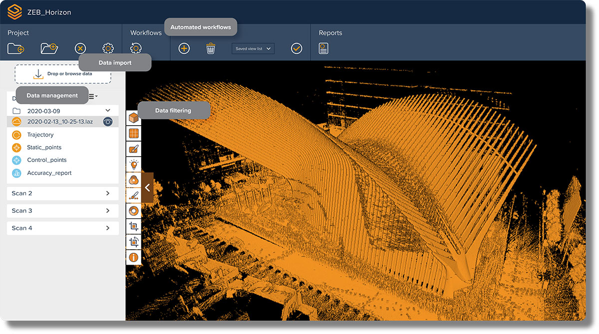
The next-generation SLAM algorithm — GeoSLAM Beam — powers the new software
GeoSLAM has released a software update, Connect 2.0, at the Intergeo 2021 trade show. Intergeo is taking place this week in Hannover, Germany.
Connect 2.0 enables GeoSLAM scanners to achieve a higher level of accuracy compared to other SLAM-based mapping systems. Colorization from the new ZEB Vision panoramic camera provides even more visual context to a point cloud, as well as interactive “bubble” walkthroughs and measurements.
The update is powered with the next generation of GeoSLAM’s algorithm GeoSLAM Beam, which includes new filtering and georeferencing tools to help users get the best results from their datasets.
Connect 2.0 also simplifies data processing through a series of workflow scripts. This includes automatic data processing, stop-and-go georeferencing and stop-and-go alignment, all available as standard.
Screenshot: GeoSLAM
Connect 2.0 Features
Intuitive interface – The Connect viewer is integrated into the main software interface, making it easy to view multiple point clouds simultaneously and measure the distance between data points.
Change detection – Multiple point clouds can be compared, and any areas that have changed are automatically highlighted. Point clouds also can be compared with CAD models to track progress on a construction site or view changes between scans.
Floor slices – Horizontal and vertical slices can be taken from any location within the point cloud. Horizontal floor slices can also be automatically taken at any given height above the floor.
Environmental presets – Data is processed according to the environment it was captured in (indoor, outdoor, UAV or vehicle).
Draw 4.0 – Draw projects can now be created automatically for any dataset.
GeoSLAM customers with a Care subscription will have full access to Connect 2.0. Any new product shipped starting today comes with both Connect and Hub software.
Real-time processing
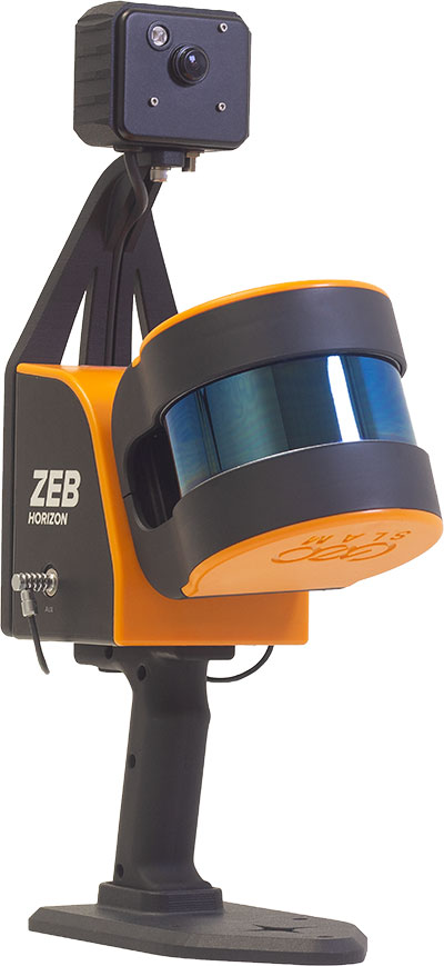
GeoSLAM has also launched real-time SLAM processing through remote access. Using an API for remote data capture or automated robotic navigation, users can see the point cloud and trajectory in real time. The ZEB Revo RT can be used on and off a robotic platform.
Photo: GeoSLAM
ZEB Vision panoramic camera
The ZEB Vision 16MP panoramic camera is now available for pre-order. Suitable for any ZEB Horizon, the new camera provides better colorization, image walkthroughs and pointcloud measurements using optional Draw software.
Use on UAVs. Further updates mean that GeoSLAM customers can now take a ZEB Horizon from handheld to UAV usage to get a more complete picture of projects. ZEB Horizon is compatible with the DJI Matrice 300 UAV.
The Trimble DA2 receiver boosts the performance of the Trimble Catalyst GNSS positioning service. (Photo: Trimble)
Trimble has launched the Trimble DA2 GNSS receiver for the Trimble Catalyst positioning service. The DA2 — the second-generation receiver and antenna for the Catalyst service — now includes the Trimble ProPoint GNSS engine for enhanced performance.
Unique to the latest Trimble GNSS solutions, ProPoint technology reduces convergence times and improves positioning accuracy when operating near trees and buildings.
Trimble Catalyst is a subscription-based GNSS positioning service for location-enabled field applications. The service is available in accuracy-based packages from centimeter- to submeter-level for a wide range of mapping and mobile geographic information system (GIS) data-collection projects. Catalyst continues to support a broad range of GIS field applications, including Trimble TerraFlex software, for form-based GIS data collection.
“Trimble Catalyst brings easy-to-use precise positioning to location-enabled workforces,” said Gareth Gibson, marketing director, Trimble Mapping & GIS. “The addition of ProPoint technology, together with the DA2’s support for iOS devices, means Catalyst can now deliver Trimble quality positioning to more geospatial professionals than ever before.”
Trimble Catalyst subscriptions are available through Trimble’s Authorized Distribution Network. The Catalyst DA2 digital GNSS receiver, sold separately, is expected to be available in the fourth quarter. Trimble TerraFlex software subscriptions are available separately through Trimble Geospatial distribution partners.
Nearmap will capture aerial imagery of more than 80% of the U.S. population up to three times a year, enabling clients to access 130,000 square miles of additional content, including double the urban coverage of oblique/3D content
Aerial imagery and location intelligence company Nearmap has expanded its United States coverage program to more than 80% of the country’s population. This massive boost in coverage provides companies that rely on high-resolution aerial imagery with improved decision-making capabilities that will help them save time, effort and money, Nearmap stated in a press release.
“Nearmap customers have asked us to increase the amount of the U.S. that we cover and we’re responding by doubling down on our coverage,” Tony Agresta, general manager of North America, Nearmap said. “Our clients will have access to 130,000 square miles of additional unique captured footprint in the United States.”
Overall, the Nearmap capture program will cover more than 1,740 urban areas within the United States, including more than 80% of the population with 308,000 unique square miles captured annually.
In capturing aerial imagery, Nearmap focuses on currency, consistency, coverage and ease of access. The imagery is published within days of capture, with 24/7 access through a web app, API or third-party integration.
“Around 11,300 customers worldwide rely on Nearmap to be their eye in the sky, and to provide them with the truth on the ground,” Agresta said. “We’re seeing strong momentum with new and existing customers in the United States. This massive boost in coverage reflects the broader investment and focus Nearmap has on the strategically important U.S. market.”
Features of the expanded mapping coverage include:
130,000 square miles of additional unique captured footprint in the United States, equivalent to about 63,000 football fields
double the number of urban areas covered with oblique/3D content
access to current content, with updates up to three times a year, including leaf-off and leaf-on collection
images at a high resolution, ranging from 2.2 to 3 inches.
Across the world, Nearmap will also capture more than 64% of the population in Canada; more than 90% of the population in Australia, and about 73% of the population in New Zealand.
“The expanded aerial coverage complements our city-scale 3D content, artificial intelligence (AI) data sets, and geospatial tools,“ Agresta said. “Nearmap has also recently tested in flight the next generation of our patented aerial camera system, HyperCamera3, to ensure our clients are supported by the very best technology in the market.”
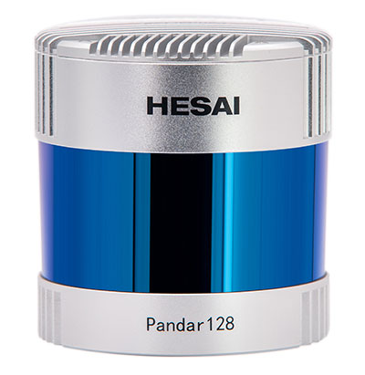
Under a new agreement, Lidar USA — a developer of geomatics solutions — will include Hesai Technology Co. Ltd., 3D lidar sensors in its product lineup. Hesai Technology announced the agreement at the Commercial UAV Expo 2021 in Las Vegas, Sept. 7-9.
The Pandar128 lidar unit. (Photo: Hesai)
Under the terms of the agreement, Lidar USA will leverage its marketing and sales expertise to distribute Hesai sensors across the United States, Canada and Mexico.
“Hesai’s product portfolio has the sensors we have all long awaited — bridging the gap between sensors made for automotive navigation and those made for precision measurement,” said Lidar USA CEO Jeff Fagerman. “Users will enjoy the affordability of the former and results of the latter.”
Hesai’s lidar units offer superior performance and reliability to ensure robust detection under different operating and environmental conditions, the company stated in a press release. Hesai’s XT sensors, embedded with proprietary lidar application-specific integrated circuits (ASICs), deliver performance advantages while maintaining a compact form factor and low cost.
The XT sensors are lightweight and draw less power, enabling longer operation for airborne applications. The XT’s precision and accuracy allows for fine detail capture.
PandarQT, a short-range sensor for blindspot detection, has a large vertical field-of-view of 104.2°. The Pandar series lidars — Pandar128, Pandar64 and Pandar40P — deliver long detection range, high resolution and high point density for optimized perception results.
“Lidars are increasingly being adopted for different end markets and applications,” said David Li, Hesai’s CEO. “We’re excited to partner with an industry leader like Lidar USA, whose strong foothold in North America will help expand access to sensors across different segments.”
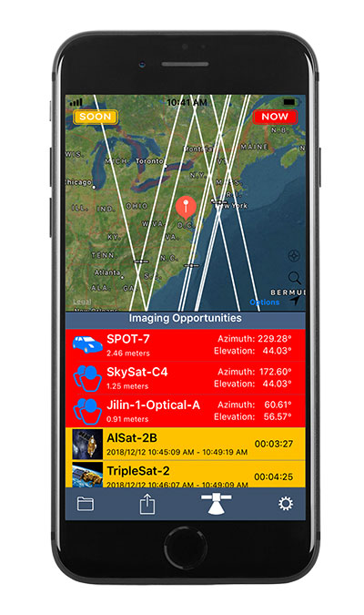
Orbit Logic’s SpyMeSat mobile app (available via the Apple App Store and Google Play) now includes an augmented reality (AR) interface for better awareness of overflying imaging satellites. The AR view overlays the orbit and position of satellites that can image your location, providing a better understanding of satellite viewing geometry and potential obstructions. For example, it makes it possible to know if an image taken by that satellite of your position would be obscured by a tree or a building. The AR interface also displays relevant information about the satellite and its capabilities, including the timing and dynamic geometry of the pass as well as the resolution achievable by satellite sensors.
In addition to real-time imaging satellite awareness, SpyMeSat provides on-demand access to recent archive satellite imagery and the ability to request new tasking directly from a mobile device. Multi-phenomenology data (optical, infrared, synthetic aperture radar, and more) is available through an in-app process of preview, select, payment, and delivery that can be completed in seconds, providing archived satellite imagery for any location on demand. When archive imagery is insufficient and new data is required, users can review available satellites, better understand the data collection environment through the AR interface, and purchase tasking based on cost, responsiveness, and capability.
While the standard SpyMeSat enables marketplace interactions between the public and commercial satellite imagery providers, Orbit Logic also develops custom mobile applications for better situational awareness and easier data-access/tasking supporting specific missions. The new AR interface will enhance these users’ mission effectiveness by facilitating better understanding of how data collection might be impacted by surrounding terrain or other spatial factors. Examples of bespoke SpyMeSat deployments include government versions for government assets and versions for awareness of satellite communications opportunities for contact scheduling, data transfer, and command uplink.
Orbit Logic specializes in mission planning and scheduling solutions for aerospace and geospatial intelligence. Its COTS products create better plans faster with fewer resources for all mission phases. Orbit Logic services are available to configure, customize, and integrate its mobile, web-based, desktop, and flight software applications to provide turn-key operational solutions that leverage the latest available technologies to meet customer goals and exceed their expectations.
EagleView, a geospatial technology provider of software, aerial imagery and analytics, and Skyline Software Systems, a provider of 3D Earth visualization software, have partnered to enable customers to visualize their geospatial data in new ways. Through this new partnership, EagleView’s high-resolution ortho and oblique imagery can be converted into 3D Mesh layers with Skyline’s PhotoMesh and viewed, edited, and analyzed on Skyline’s TerraExplorer platform.
EagleView customers will be able to utilize Skyline’s TerraExplorer web-based GIS viewer and editor to see, analyze, and share their imagery in an immersive environment. Accurately measuring distance, area, and volume is now easier than ever, which is critical for planning and zoning to verify regulations or estimate the costs of flattening a site. With floodplain analysis, disaster management can identify flood risks before they happen, and with viewshed calculations E911 can pre-plan for high-profile events. Other key analytic features for customers will include the ability to analyze shade, view contour and slope maps, and view in underground mode. Beginning immediately, the additional 3D Mesh capability is now available as an add-on to any new Reveal Essentials+ Property or Neighborhood image capture.
Skyline offers a comprehensive platform of applications, tools, and services that enable the creation and dissemination of interactive, photo-realistic 3D environments. Its products are production proven in both the defense and commercial markets.
EagleView develops geospatial technology, providing software, imagery, and analytics. The company has the largest geospatial data and imagery library in history, covering 94 percent of the U.S. population. Its technology with more than 300 patents creates highly differentiated software, imagery, and analytics products for a diverse customer base.
Kongsberg Geospatial has released TerraLens 9.3, the latest version of its real-time software development toolkit for geospatial visualization. In this release of TerraLens, the product development team has focused on improving performance for 3D visualization for large viewports and on multi-domain visualization features for joint all-domain command and control applications. Leveraging the power of modern GPUs and multi-core processors, the latest release of TerraLens is significantly faster, with new presentations focused on enhancing situational awareness.
With increased multithreading in its map handling, TerraLens can load and display vector, raster, and elevation formats smoothly without pre-processing. This is ideal for applications that have disk size constraints or for customers that have a short turn-around time between receiving map data updates and needing to use them. For applications with stringent start-up constraints or map formats that are not optimized for quick runtime access, the pre-processing option still exists, to help ensure minimal time for an initial map display.
The rendering of maps and dynamic presentations has also been optimized with increased threading in the graphics kernel, and the minimization of costly graphics state changes with batched rendering calls. Improved data culling ensures that only visible items will be rendered. These improvements are especially noticeable when displaying large numbers of dynamic tracks and objects, and frequently projected information.
This release of TerraLens also includes a slate of new tools and features, including support for OGC 3D Tiles, which can be used to create a high-resolution 3D view that is especially suited to cityscapes, while a new API to control the resolution of the terrain mesh allows applications to balance runtime performance with higher resolution terrain over which to drape map imagery. Elevation warnings can now be displayed using color ramps on both terrain and OGC 3D Tiles, as well as on primitive lines and area fills.
TerraLens continues to evolve to meet the latest map and symbology standards. Support has been added for the latest military symbology, providing MIL-STD-2525D and App-6B symbol sets. The SDK also features new mapping updates including enhanced support to discover WMS and WMTS map layers as well as monitoring the status of web requests. Support has been added for DAFIF 8.1 and S-57 Inland ENC levels. Developers will be able to track when maps have completed loading in the TerraLens viewport. TerraLens 9.3 also continues to support the latest development environment needs, including Visual Studio 2019, CLI .Net Core, and Linux RedHat8.
TerraLens has been fielded in some of the most demanding applications in the world including AEGIS, Global Hawk, THAAD, NATO AWACS, and the Joint Battle Command-Platform.
Based in Ottawa, Canada, Kongsberg Geospatial creates precision real-time software for air traffic control and UxS and situational awareness. The company’s products are primarily deployed in solutions for air-traffic control, command and control, and air defense. During nearly three decades of providing dependable performance under extreme conditions, Kongsberg Geospatial has become the leading geospatial technology provider for mission-critical applications where lives are on the line. Kongsberg Geospatial is a subsidiary of Kongsberg Defence & Aerospace.
The Nippon Foundation-GEBCO Seabed 2030 Project and Kongsberg Maritime have entered a memorandum of understanding (MOU) in support of the global initiative to produce the complete map of the ocean floor. Under the terms of the MOU, the two parties will work together to advance understanding of ocean bathymetry. The effort complements the goals of the United Nations Decade of Ocean Science for Sustainable Development.
Seabed 2030 is a collaborative project between The Nippon Foundation and GEBCO to inspire the complete mapping of the world’s ocean by 2030 and to compile all bathymetric data into the freely available GEBCO Ocean Map. GEBCO is a joint project of the International Hydrographic Organization (IHO) and the Intergovernmental Oceanographic Commission (IOC) and is the only organization with a mandate to map the entire ocean floor.
Kongsberg Maritime provides solutions for safe, efficient, and sustainable maritime operations. The solutions are suitable for offshore energies, seaborne transportation, hydrography, science, navy, coastal marine, aquaculture, training services and more. Kongsberg Maritime is the largest business area within Kongsberg Gruppen ASA. The Group has an integrated portfolio of solutions for businesses, partners and nations operating from the depths of the sea to outer space and to the digital frontier.
All data collected and shared with the Seabed 2030 Project is included in the GEBCO global grid, which is free and publicly available.
The Nippon Foundation-GEBCO Seabed 2030 Project is a collaborative project between The Nippon Foundation and GEBCO. The Seabed 2030 Project, launched at the United Nations Ocean Conference in 2017 by Chairman Sasakawa of The Nippon Foundation, coordinates and oversees the sourcing and compilation of bathymetric data from different parts of the world’s ocean through its five centers into the freely-available GEBCO Grid.
Kongsberg Maritime is a global marine technology company providing technology solutions for all marine industry sectors including merchant, offshore, cruise, subsea and naval.
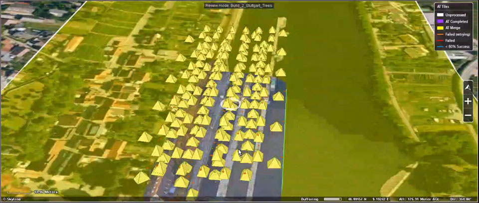
SPH Engineering has released a lidar toolset update to UgCS — the company’s UAV mission planning and flight control software. The lidar toolset is designed to eliminate human error in remote sensing.
Features include precise calibration, flight patterns for route planning, anti-shake turns, and constant line spacing and buffer.
The UgCS lidar toolset allows users to optimize time and cost-effectiveness at all stages of data collection and processing. At the flight planning stage, time is saved on mission planning, with flight patterns and turns designed specifically for lidar surveys.
At the flight stage, users can acquire high-quality laser data with preset inertial measurement unit (IMU) initialization patterns and anti-shake lidar turns. During post-flight data analysis, the high accuracy of the acquired data ensures the desired results with a single trip to the field
“We have received various requests from lidar producers and end-users to improve the accuracy of laser data collected with a UAV,” said lexei Yankelevich, head of software development at SPH Engineering. “We have invested in UgCS R&D to focus mainly on automated IMU calibration commands, automatic calculation of required line spacing and overlap, and prevention of sensor shaking. Trial flights over SPH Engineering’s in-house test range have confirmed UgCS lidar toolset capacity to support main lidar market players.”
Application areas include power line inspections, road inspections, construction, mining, archaeology and forestry.