Category: Mapping

  • Geospatial imagery shows activity at Iranian nuclear facility

    Geospatial imagery shows activity at Iranian nuclear facility

    A team with Stanford University’s Center for International Security and Cooperation (CISAC) used BlackSky’s geospatial imagery and burst collection technology to track and monitor activity at a secretive Iranian nuclear facility in a new intelligence study. The study tracks and monitors activity at the Natanz nuclear facility in Iran.

    Screenshot: Janes.com video/BlueSky
    Screenshot: Janes.com video/BlueSky

    “The BlackSky/CISAC research team demonstrated the power of combining rapid revisit satellite imagery, human domain expertise and AI/ML (artificial intelligence/machine learning) techniques to identify and understand activity at Natanz, which was previously unknown to much of the world,” said Patrick O’Neil, chief data scientist at BlackSky. “Observations that provide real-time, activities-based insights have the potential to change the world.”

    BlackSky’s high-revisit satellite imagery enabled researchers at Stanford University’s Center for International Security and Cooperation (CISAC) to monitor the pattern of life at the Natanz nuclear facility and gain a better understanding of activity and events at the site.

    BlackSky’s satellites provide high, intraday revisit capabilities, allowing CISAC’s research team to receive multiple images a day, throughout the day, rather than just one image collected at roughly the same time each day.

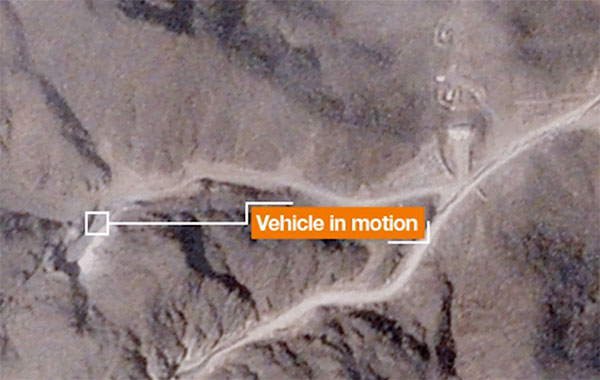
    BlackSky satellites are also capable of capturing a sequence of up to 20 images within a matter of minutes, known as a burst collection, and then splicing them together. Instead of a single picture, burst collections are geospatially normalized and joined together to generate a moving sequence of activity. With BlackSky’s assistance, the research team was able to witness trucks emerging from the facility’s underground tunnels.

    Allison Puccioni, a renowned imagery analyst and BlackSky consultant, assembled a research team at Stanford University, with help from Rose Gottemoeller, diplomat, former NATO deputy secretary, and visiting professor at Stanford. The pair enlisted two principal research assistants in geospatial science to develop a sophisticated situational-intelligence program to monitor the Natanz nuclear facility.

    Natanz is Iran’s primary facility for advanced uranium enrichment and is an active political and military location driven by concerns about the country’s nuclear operations.

  • Charting Hong Kong’s nooks and crannies

    Charting Hong Kong’s nooks and crannies

    Photo: Yongyuan Dai/iStock/Getty Images Plus/Getty Images
    Photo: Yongyuan Dai/iStock/Getty Images Plus/Getty Images

    Team Provides Accurate 3D Maps for Smart City Applications

    The PolyU team's mobile mapping backpack. (Image: The Hong Kong Polytechnic University)
    The PolyU team’s mobile mapping backpack. (Image: The Hong Kong Polytechnic University)

    According to 2019 statistics, more than 10,000 residential buildings in Hong Kong are at least 50 years old. Most of these buildings lack 3D indoor building information models (BIM), which creates challenges when it comes to reconstruction or maintenance.

    In response, a team at Hong Kong Polytechnic University (PolyU) has developed a lightweight and reliable 3D mobile mapping system in a backpack. The system can easily measure cities and obtain 3D maps with centimeter-level accuracy. It can be used to build spatial data infrastructure, which supports smart city applications in many fields.

    The system uses advanced technologies such as simultaneous localization and mapping (SLAM), useful in urban canyons where GNSS signals can be spotty. It can carry out continuous data collection in complex indoor and outdoor environments, and is particularly suitable for high-density and complex urban environments, such as those in Hong Kong.

    The mapper is providing a special boon to modular integrated construction (MIC) in the city. With MIC, free-standing integrated modules are prefabricated and then transported to the site for installation in a building. However, the trucks hauling the large components can’t always maneuver through narrow streets in Hong Kong’s urban areas.

    One of many narrow streets mapped in downtown Hong Kong. (Image: The Hong Kong Polytechnic University
    One of many narrow streets mapped in downtown Hong Kong. (Image: The Hong Kong Polytechnic University

    To address the issue, the PolyU team collaborated with the Hong Kong Construction Industry Council, providing its mobile-mapping backpack to conduct 3D measurement of critical road sections. The project identified and mapped obstacles, and optimized the route for transporting oversized components to avoid narrow passages.

    Mobile-mapping backpacks also can be used to create detailed indoor 3D models to support firefighting and provide evacuation routes for personnel at the fire scene.

    The route taken by the mobile mapping backpack carrier in the harbor area. (Image: The Hong Kong Polytechnic University)
    The route taken by the mobile mapping backpack carrier in the harbor area. (Image: The Hong Kong Polytechnic University)
    A sample point cloud from the mobile mapper. (Image: The Hong Kong Polytechnic University)
    A sample point cloud from the mobile mapper. (Image: The Hong Kong Polytechnic University)

    The mobile mapper is one of the technologies developed by PolyU’s Smart Cities Research Institute, established in 2020 to help address social issues and provide solutions for smart city development. In March, the institute’s projects received a gold medal at 2021 Inventions Geneva Evaluation Days.


  • Septentrio’s AsteRx SBi3 enables XenomatiX lidar 3D mapping

    Septentrio’s AsteRx SBi3 enables XenomatiX lidar 3D mapping

    AsteRx SBi3 enables highly accurate and reliable 3D mapping solutions based on sensor fusion with lidar

    The AsteRx-i3 Pro+ in a rugged housing. (Photo: Septentrio)
    The AsteRx-SBi3 Pro+ in a rugged housing. (Photo: Septentrio)

    Septentrio, a leader in high-precision GNSS/INS positioning solutions, and XenomatiX, provider of true solid-state lidar technology for autonomous applications and road management solutions, are starting a partnership enabling high-quality lidar solutions.

    XenomatiX will be using the compact and robust GNSS/INS receiver from Septentrio, AsteRx SBi3 Pro+, to provide analysis of pavement conditions geolocated with millimeter accuracy.

    Septentrio’s high-quality GNSS/INS will be a part of Xenomatix’ road lidar XenoTrack, used by road surveyors and road management companies. Septentrio’s AsteRx SBi3, a high-performance RTK GNSS/INS receiver with a dual-antenna setup, ensures centimeter-accurate geotagging of the XenoTrack point-cloud frames for relative and global millimeter accuracy over large distances.

    Moreover, the GNSS/inertial measurement unit (IMU) integration algorithm enables dead reckoning — continuous positioning in environments of low satellite visibility where GNSS outages occur.

    While traditional road scanning based on laser profilers rely solely on extremely accurate GNSS/inertial navigation system (INS) to stitch consecutive profiles together, the XenoTrack captures a 3D topography of an entire area in a single shot. The XenomatiX sensor-fusion algorithms combine visual SLAM techniques with GNSS, IMU and CAN to obtain a seamless map of the road shape.

    Septentrio’s proprietary GNSS+ technology plays a key role in delivering the accuracy and reliability needed for XenoTrack. The company’s AIM+ advanced interference mitigation technology ensures robust positioning even in the presence of jammers, which may be aboard vehicles trying to avoid road tolling. When the sky is obstructed for an extended period, the built-in RAIM+ integrity algorithm serves as an indicator of when it is best to give priority to other sensor inputs to maintain a high-quality solution.

    XenomatiX offers a complete mapping system as well as services including data from the XenoTrack sensor, camera and real-time kinematic GNSS/INS receiver with dual antenna in an easy-to-install solution on a standard vehicle.

  • Juniper Systems launches Cedar rugged tablet with GNSS functionality

    Juniper Systems launches Cedar rugged tablet with GNSS functionality

    Photo: Juniper Systems
    Photo: Juniper Systems

    Juniper Systems is has launched its latest rugged tablet, the Cedar CT8X2. The new tablet offers increased processing power, RAM and storage, running on the Android 10 operating system. Despite these features, the CT8X2 retains the same powerful GNSS functionality of the previous Cedar generation for the same price.

    “The CT8X2 is our best Cedar tablet to date,” said Cody Draper, Cedar product manager. “It exceeds expectations in terms of price, performance and versatility. It is a perfect device for those looking for a mobile data-collection device that offers a much greater degree of ruggedness than a consumer product.”

    Powered by an octa-core Snapdragon CPU from Qualcomm, the CT8X2 allows for larger files compared to the previous Cedar. Greater onboard storage prevents users from needing to offload data frequently and provides sufficient space for applications. With GNSS accuracy of about one meter in open skies and five meters under tree canopy, the CT8X2 offers capable GNSS positioning that far exceeds the accuracy of typical consumer devices. The CT8X2 also has a high-resolution screen.

    “The performance increase of the CT8X2 gives users a very capable device in the field,” Draper said. “We were able to provide these advancements in performance and GNSS accuracy while maintaining our affordable price point.”

    The CT8X2 is now available for purchase.

  • Building a better world: Esri UC announces plenary speakers

    Building a better world: Esri UC announces plenary speakers

    logo

    The 2021 Esri User Conference — taking place virtually July 12-15 — has announced its plenary session theme and speakers.

    “At this year’s plenary session, we’ll explore a vision for building a better world,” said Esri President Jack Dangermond, who will deliver the keynote address. With the theme of GIS—Creating a Sustainable Future, attendees can learn from leaders in human storytelling, racial equity, ocean preservation and climate resilience, as well as discover the latest geospatial innovations.

    Following the keynote, a two-part Plenary Session provides conversations and stories from these speakers:

    • Paul Salopek | Founder, Out of Eden Walk, National Geographic
      A Walk Through the Anthropocene
    • La June Montgomery Tabron | President and CEO, W.K. Kellogg Foundation
      Expanding Racial Equity through Community Action
    • Enric Sala | Explorer in Residence, National Geographic Pristine Seas
      2021–2030: Our Last Best Chance to Protect the Ocean for the Benefit of Humanity
      Protecting the Global Ocean for Biodiversity, Food and Climate
    • Secretary Wade Crowfoot | California Natural Resources Agency
      Nature-Based Solutions in California: Combating Climate Change and Achieving 30×30

    The Esri UC will also provide a look at new GIS technologies in expert-led demonstrations, including ArcGIS Image for ArcGIS Online. Attendees can learn to directly integrate imagery into your workflows by fast-tracking image analysis and easily sharing data to derive and communicate critical insights.

    Registration for the Plenary Session is complimentary. Full event access is available to Esri users current on their maintenance or subscriptions.

    The detailed agenda for the conference is available online.

  • Mapping rights-of-way subject of July 13 virtual conference

    Mapping rights-of-way subject of July 13 virtual conference

    Photo: Jordanlye/iStock/Getty Images Plu/Getty Images
    Photo: Jordanlye/iStock/Getty Images Plu/Getty Images

    The 2021 Right-of-Way Asset Mapping Exchange is an interactive online Virtual Conference Experience focusing on innovation in asset inventory and mapping that supports all phases of infrastructure lifecycles. It takes place July 13 and is free of charge.

    The event provides hands-on actionable information on a variety of current and emerging technologies. Via presentations, discussions and one-on-one meetings, the event gives those who attend an opportunity to learn from and engage with technology and experts in a wide range of disciplines, and some of their key clients, as well as peers and colleagues.

    Moderator of the event is Matteo Luccio, GPS World editor in chief. Speakers include:

    Why ROW Asset Mapping?

    ​Right-of-way (ROW) corridors, especially in urban areas, are densely populated by many public and private infrastructure features — overhead electric and telephone wires, street-level parking meters, signage, traffic sensors, underground fiber-optic cables, water mains, natural gas pipes and sewers. They are constantly changing environments, as additional poles, signs and conduits are installed and old ones are replaced with newer ones to restore service after storm damage.

    Yet public works and utility managers, engineers and planners need to know what each stretch of each ROW corridor contains at any given moment, especially as they work to make our cities “smarter.” Hence, the Sisyphean task of mapping these assets.

    Fortunately, the technology to map ROW assets is rapidly improving. Platforms for data collection include vehicles driving at normal traffic speeds, UAVs and manned aircraft. Sensors include digital cameras, lidar scanners and ground-penetrating radar.

    Visualization tools include augmented reality, virtual reality, mixed reality and models ranging from small 2D and 3D ones of individual features up to digital twins of buildings and, eventually, entire cities. Increasingly, the tedious work of identifying and classifying features is being delegated to automated feature extraction software, a form of artificial intelligence.

    The conference will discuss

    • Comparing 2D and 3D visualization tools.
    • Explaining the benefits of 3D models as an advanced spatial analysis tool for urban planning.
    • Exploring the future of smart cities and digital twins.
    • A light equity study and pole inventory in the context of the transition to LED lighting.
    • How a two-man team can capture 500 miles worth of utility data in two weeks.

    Registration is free.

  • 1Spatial updates 1Integrate and 1Data Gateway for geospatial workflows

    1Spatial updates 1Integrate and 1Data Gateway for geospatial workflows

    1Spatial logo1Spatial is making complex workflows easier to manage with the latest releases of its core products 1Integrate and 1Data Gateway. 1Spatial is a global geospatial software and solutions company.

    1Data Gateway 2.4 now has an extended REST API enabling automated submission of data from other applications, while maintaining access control and security of the data supply chain. Submission metadata can be passed back into 1Integrate sessions for downstream processes and analysis. 1Integrate 2.10 can also be configured to “fast-track” certain sessions onto higher priority engines, ensuring important submissions are not left queuing behind other routine jobs.

    “Even though 1Data Gateway is primarily a user portal to our rules engine, the addition of the Submission API will allow our customers to integrate the power of 1Data Gateway into automated workflows and access the rich statistical data collected from the submissions,” said Ricardo Cifres, 1Data Gateway product manager.

    UK Contract Awarded

    Following a competitive tender and in collaboration with Version 1, a global IT services and solutions company, has signed a multiyear contract with the United Kingdom Department of Environment, Food and Rural Affairs (DEFRA) to provide a managed service for the Rural Payments Agency’s (RPA) Rural Payments Service and Land Management System (LMS).

    The contract will provide a recurring managed service enabling DEFRA and the Rural Payments Agency to deliver its current Basic Payment and Countryside Stewardship Schemes. In addition, the new contract enables 1Spatial and Version 1 to support RPA and DEFRA through Agricultural Transition.

    1Spatial has worked with RPA over the past five years to support and develop its Land Management System, an ecosystem of IT components, processes and data, including 1Integrate software. The LMS is RPA’s key control system used as a remote-sensing monitoring tool and to master the land registration data used for subsidy-scheme validation and agricultural policy implementation.

  • NextNav goes public with Spartacus Acquisition Corp.

    NextNav goes public with Spartacus Acquisition Corp.

    NextNav logoGPS company NextNav and Spartacus Acquisition Corp, a special-purpose acquisition company, has entered into a definitive merger agreement that will result in NextNav becoming a public company. The combined company will be named NextNav Inc. Its common stock and warrants will be listed on the Nasdaq under the ticker symbol “NN” and “NNW”, respectively.

    Gross proceeds of up to $408 million from the business combination are expected to be used to fuel growth in its current businesses, continue to build NextNav’s next-generation GPS platform, expand products (one of which is already deployed in 4,400 cities), and to expand its land-based radio positioning and timing network.

    The NextNav platform serves a $100 billion global total addressable market in public safety, E911, mass-market consumer apps, eVTOLs, UAVs and autonomous vehicles, internet of things (IoT), critical infrastructure and other sectors. Beyond its technology and intellectual property, NextNav owns a portfolio of nationwide spectrum licenses for 2.4 billion MHz-PoPs of 900 MHz spectrum.

    Gary Parsons, former chairman of the board of Sirius XM Radio, has served as chairman of NextNav’s board of directors for the past 10 years and will continue in that role. Peter Aquino, chairman of the board and CEO of Spartacus, will also join the NextNav board upon closing of the business combination. Aquino has led several companies through fiber and wireless operations and network deployments, and the development of overlay technologies designed to drive new revenue streams.

    NextNav will continue to be led by Ganesh Pattabiraman, the company’s co-founder, CEO and president. Pattabiraman, who started at Qualcomm, has experience in building scalable location technologies using terrestrial and satellite-based technologies,

    In addition, the full NextNav management team — co-founder Arun Raghupathy, SVP of Engineering; Chris Gates, CFO; and David Knutson, SVP of Network Operations and Deployment — will continue to manage NextNav.

    Hogan Lovells is advising NextNav with corporate and finance partner Randy Segal and partners Adam Brown, John Duke, and Jessica Bisignano leading the team. Senior associates Michael Rogers and Liz Banks, and associate Chelsea Shrader assisted as well.

  • Kaarta and EXI join to address UXO mapping in GNSS-denied environments

    A technician scans for UXO on steep terrain in a wooded GPS-denied area. (Photo: Kaarta)
    A technician scans for UXO on steep terrain in a wooded GPS-denied area. (Photo: Kaarta)

    Kaarta and Exploration Instruments have announced a collaboration and distribution agreement to address the needs of the unexploded ordnance (UXO) and geophysical industries.

    Kaarta provides real-time mobile 3D reality capture, and Exploration Instruments LLC (EXI) has expertise in near-surface geophysical equipment and applications.

    EXI now offers rental, sales, and training for Kaarta’s SLAM-based mobile mapping systems and the integration with geophysical equipment such as digital geophysical mapping (DGM) and advanced geophysical classification (AGC) sensors.

    Contamination and munitions from former combat areas or military training grounds is a global hazard. In the U.S. alone, more than 5,400 sites covering millions of acres have been identified for investigation and environmental restoration according to the U.S. Army Corps of Engineers.

    The general remediation approach pinpoints buried ordnance location using electromagnetic and magnetic detection systems with GNSS positioning technology. While these systems perform well in open areas, other common environments such as steep terrain and wooded areas under tree canopy are challenging to find and remediate UXO.

    The most common method for achieving required positional accuracy for DGM or AGC in wooded terrain is the use of robotic total stations (RTS) to tie surveyed locations to detection systems. However, RTS line-of-sight requirements make mapping and classification difficult and time-consuming, resulting in slower production rates and increased effort as data-collection teams must revisit common data gaps in the RTS coverage to achieve 100% coverage of the mappable areas.

    Kaarta’s simultaneous location and mapping (SLAM) solution provides accurate global positions within several centimeters in these demanding environments. Kaarta Stencil 2-16 mobile mapping system combines lidar, an inertial measurement unit (IMU) and visual odometry measurements to build a 3D map of the environment while updating global position data in real-time when moving through the map, without the need for external signals such as GNSS.

    The U.S. Army Corps of Engineers tested Kaarta’s Stencil 2-16 to provide rapid positioning data in GNSS-denied areas and found it provides positional data with the required accuracy for DGM and AGC at military munitions response sites.

    Kaarta systems are successfully integrated and used with a range of geophysical equipment including Geometrics MetalMapper 2×2, Geonics EM-61, and White River Technology’s APEX systems. EXI ties it together by providing geophysical expertise, training and access to the latest equipment through both rental and sales. Stencil 2-16 integration with other sensors is easy using customizable GNSS NMEA strings and supports a wide range of RS-232, USB and Ethernet interfaces.

    “It’s exciting when a combination of technologies come together to address such a significant problem as locating UXO in the most challenging of environments,” said Dave Duggins, UXO applications specialist at Kaarta. “We’ve been out in the woods with customers and are thrilled with the results we’ve achieved which include increased production rates with fewer personnel. Partnering with EXI to bring this solution to market is a perfect match.”

    “There are hundreds of thousands of wooded acres that still need to be remediated,” said Dennis Mills, EXI’s President, “Providing geophysicists with a proven integrated solution that significantly improves productivity over current methods is a win all around.”

    Kaarta systems can also be integrated with other sensors that use GNSS for positioning – ground penetrating radar, magnetometers, terrain conductivity meters — for a wide range of applications where positioning is needed in GNSS-denied areas. Kaarta was recently issued a patent covering its novel approach to fuse data captured by SLAM systems with data from other sensors to measure and localize sensed data in the scanned environment.

    EXI will be the primary provider of Stencil 2 rentals, sales, and training to the UXO and geophysical industry.

  • Skyward collaborates with Pix4D mapping and modeling

    Screenshot: Skyward
    Screenshot: Skyward

    Skyward, a Verizon company, has announced its integration with Pix4D, a photogrammetry software suite for drone mapping. The partnership gives customers the ability to turn drone data into 2D maps and 3D models.

    Enterprises and drone pilots can now plan flights, receive approval to fly in controlled airspace with LAANC, fly with Skyward’s InFlight ground control station, and process data using Pix4D — all from within the Skyward platform.

    “Skyward has been bringing our customers tools to access airspace, plan and fly — now they can produce business-ready data deliverables without leaving Skyward,” said Mariah Scott, Skyward president. “Enterprises in construction, energy and utilities, and the public sector can get even more ROI out of their drone programs when combining Skyward’s drone management platform with Pix4D’s market-leading photogrammetry tools.”

    Skyward Mapping & Modeling, powered by Pix4D, enables customers to create, view, measure, and export 2D orthomosaic maps and 3D photogrammetric models right from Skyward’s web app. With the processing power of Pix4D, Skyward customers can get business-ready data sets through a seamless plan, fly, process workflow.

    “Enterprises are seeking to scale their drone operations and transform their businesses with better data and faster time to insight. Skyward’s platform, along with the power of Pix4D, delivers a powerful, comprehensive solution,” said Christopher Cressy, Pix4D managing director for North America.

    To learn more about Skyward’s mapping and modeling features, join a webinar on June 8 at 2 p.m. ET. Enterprises and commercial operators can try Skyward Mapping & Modeling powered by Pix4D free for 30 days.

  • IIT Roorkee offers free online course on GNSS and DEMs

    The Indian Institute of Technology (IIT) Roorkee is offering a free online course on GNSS and Applications on the NPTEL platform. The four-week course will provide a basic understanding about digital elevation models (DEMs) and their applications in civil engineering and Earth sciences.

    During the course, various DEMs and their sources, generation techniques, derivatives, errors and limitations will be discussed extensively. Surface hydrologic modeling using DEMs, modeling derivatives and their applications will also be discussed.

    Intended audience. Under- and post-graduate engineering and post-graduate science students and faculty.

    Pre-requisites. Current students of engineering, post-graduate science students and Ph.D. students should have basic knowledge of geographic information systems (GIS) and remote sensing.
    Industry support. Geoinformatics companies (such as NIIT, Esri India, Leica Geoinformatics, MapmyIndia, ISRO and more).

    The course will be taught by Arun K. Saraf, professor in the Department of Earth Sciences at IIT Roorkee. He teaches courses on remote sensing, digital image processing, GIS, advanced GIS, geomorphology and related topics to undergraduate and postgraduate students of Geological Technology and Applied Geology. He has a Ph.D. in remote sensing from the University of Dundee, United Kingdom.

    The course takes place July 26-August 20. Registration is open until August 2 and can be done through the SWAYAM platform.

  • NV5 Geospatial acquires Geodynamics to expand marine survey offerings

    NV5 Geospatial acquires Geodynamics to expand marine survey offerings

    Multi-beam bathymetry and topo/bathy beach profiles of the Cape Fear River Inlet (USACE Wilmington). (Image: NV5 Geospatial)
    Multi-beam bathymetry and topo/bathy beach profiles of the Cape Fear River Inlet (USACE Wilmington). (Image: NV5 Geospatial)

    Following its March 29 acquisition of Geodynamics LLC, NV5 Geospatial has built a comprehensive suite of solutions for geospatial surveys of deep-water and near-shore environments. Geodynamics will operate as a wholly owned subsidiary of NV5 Global as part of the NV5 Geospatial group.

    The acquisition brought together complementary, advanced technologies — Geodynamics’ full ocean-depth sonar-based hydrographic and geophysical surveying with NV5 Geospatial’s topographic and bathymetric capabilities. Together, the technologies deliver detailed insights for a variety of applications, including coastal management, flood monitoring, ecosystem protection, research and more.

    “This acquisition was a natural evolution toward our common goal of delivering valuable geospatial insights to our clients,” said Kurt Allen, vice president, Federal Vertical for NV5 Geospatial, powered by Quantum Spatial. “Our decades’ of combined experience and expertise using the most sophisticated technology for data acquisition and analysis will enable us to meet the most demanding client requirements.”

    Geodynamics is a pioneer in collecting and processing single-beam, multi-beam, sidescan, geophysical and acoustic backscatter hydrographic data in some of the most challenging coastal environments, including dynamic tidal inlets, high-energy surf zones, and rapidly changing shoal systems that challenge navigation.

    Geodynamics has completed large-scale hydrographic survey projects in the coastal and adjacent ocean areas of the entire United States, including detailed hydrographic surveys to support federal nautical chart updates in the Atlantic, Gulf of Mexico and Great Lakes region for the Office of Coast Survey of the National Oceanic and Atmospheric Administration (NOAA).

    With a research focus on coastal geology, Geodynamics’ offshore geophysical surveys have supported mapping of marine minerals, benthic habitat and identification of potential submerged archaeological resources.

    The relationship between the companies began with a joint venture in 2019. Working collaboratively as MarineGeoSpatial LLC, the partnership provided aerial- and ship-based remote sensing for offshore/marine survey and data collection, mapping and data analysis, and marine enterprise GIS services.

    “We are excited to embark on this new chapter with NV5,” said Geodynamics CEO Sloan Freeman, PLS. “It is the perfect strategic alignment of aerial, subsea survey and geospatial services. Together, we have the technology, tools and experience to provide the best solutions to our clients and continue to advance scientific knowledge about coastal environments.”