The Trimble TDC150 handheld is a new field computer designed for GIS data collection, inspection and management activities.
The TDC150 provides users with a rugged device that has the flexibility of a handheld, a modern interface with open Android operating system, and scalable high-accuracy positioning for professional field workflows.
The TDC150 provides advanced GNSS capabilities in a durable, ergonomic and lightweight form factor. With a built-in GNSS antenna, the TDC150 is a scalable solution that allows customers to choose their desired accuracy. Easy-to-use and carry in the field, it features a bright 5.3-inch sunlight-readable touch screen and an all-day battery for continuous work on the jobsite, the company said.
The handheld comes with Google Mobile Services certification to run Google core applications and access thousands of apps on the Google Play Store. Professional GIS field applications, including Trimble TerraFlex software — a cloud-based solution that enables users to easily collect, manage and edit their geospatial feature data — are supported, as well as Trimble Penmap for Android software and Esri’s Collector for ArcGIS mobile app.
A new innovative TerraFlex workflow uses the TDC150’s onboard rear-facing camera to capture features. This visual aid shows users when the camera and receiver are aligned over features, enabling horizontal centimeter accuracy when holding the device.
“The mapping and GIS industry, including utility companies, local government, and environmental management agencies, look to Trimble for continued innovation,” said Rachel Blair-Winkler, business area manager for Trimble Mapping & GIS solutions. “Adding the ability to get the level of horizontal accuracy required in a handheld configuration without the need for an external pole and antenna, and the new camera-based data logging workflow, gives our customers the flexibility to accomplish more while out in the field.”
Detailed 3D maps of the iconic and historic Notre Dame Cathedral in Paris hold out hope for accurate reconstruction after it was devastated by a massive fire April 15. Both the ceiling and the spire were destroyed, as well as internal woodwork.
But the information to restore the cathedral is abundant. Besides photos, in 2015 art historian Andrew Tallon used laser scanners to create an immaculately accurate model of the cathedral, as reported in this National Geographic feature.
Laser scans, with their exquisite precision, don’t miss a thing. Mounted on a tripod, the laser beam sweeps around the choir of a cathedral, for example, and measures the distance between the scanner and every point it hits. Each measurement is represented by a colored dot, which cumulatively create a three-dimensional image of the cathedral. “If you’ve done your job properly,” says Tallon, the scan is “accurate to within five millimeters [.5 centimeter].”…
Tallon figured out how to knit the laser scans together to make them manageable and beautiful. Each time he makes a scan, he also takes a spherical panoramic photograph from the same spot that captures the same three-dimensional space. He maps that photograph onto the laser-generated dots of the scan; each dot becomes the color of the pixel in that location in the photograph.
As a result, the stunningly realistic panoramic photographs are amazingly accurate. At Notre Dame, he took scans from more than 50 locations in and around the cathedral—collecting more than one billion points of data.
Assassin’s Creed Unity. Another source comes from a video game company. Immaculate models of the cathedral were collected for the creation of the best-selling “Assassin’s Creed: Unity,” where the hero/player is able to climb both the outside and inside of the massive edifice.
An artist for the Ubisoft game, Caroline Miousse, told The Verge:
In the case of the Notre Dame, easily the biggest structure in the game, it meant recreating a version of the cathedral that didn’t actually exist at the time. Level artist Miousse spent literally years fussing over the details of the building. She pored over photos to get the architecture just right, and worked with texture artists to make sure that each brick was as it should be.
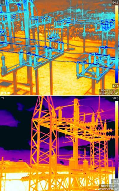
An Arizona electric cooperative that serves more than 33,000 customers is helping prove the value and potential of unmanned aerial systems (UAS) in enhancing the utility’s geospatial information system (GIS) effort.
Using an Intel Falcon 8+ Drone — Topcon Edition, UAS specialist Skynetwest is performing missions to illustrate the viability of UAS technology. Initial work for the Navopache Electric Cooperative (NEC) included inspection of a substation, conducted on a windy day that might have grounded traditional aircraft.
Windspeed limits for the Falcon 8+ in GPS mode are set at 26 mph; in height mode that threshold is extended to windspeeds as high as 35 mph.
Using ContextCapture and Agisoft PhotoScan software, Skynetwest created a detailed georeferenced 3D model of the substation.
The Falcon 8+ also has triple-redundancy inertial measurement units (IMUs), double redundant compasses, dual-constellation GPS, eight propellers and two batteries. An algorithm selects the most accurate of the redundant systems to use when the UAS is flying near the electromagnetic frequencies emitted by power lines.
The team easily switched between a camera payload for inspections and one for mapping. Skynetwest’s mapping package takes high-resolution geo-referenced aerial images from various heights within set GPS tolerances. Its RGB camera delivers both orthophotos and 3D models in Topcon ContextCapture software, powered by Bentley Systems.
The WingtraOne vertical take-off and landing (VTOL) fixed-wing mapping drone now carries the RedEdge-MX multispectral sensor for vegetation mapping.
The WingtraOne is a VTOL drone that allows for flexible take-off and landing, with automated vertical take-off and landing even on gravel or in forest isles.
The WingtraOne provides wide coverage for comprehensive and high-quality multispectral image gathering, with coverage of up to 160 ha (395 ac) with 8.2 cm (3.2 in)/px GSD at 120 m/ 394 ft in one flight.
The Terrain Following feature provides for intuitive flight planning with fully automated functionality, the company said.
The RedEdge-MX features a patent-pending DLS 2 and a calibrated reflectance panel that enhances radiometric calibration and provides useful data for comparison of results over time, improving crop and stand monitoring.
The camera captures five narrow spectral bands: red, green, blue, near infrared and red edge. It generates plant health indexes and RGB (color) images from one flight, and is calibrated for precise, repeatable measurements.
Standard data outputs are compatible with almost all processing platforms.
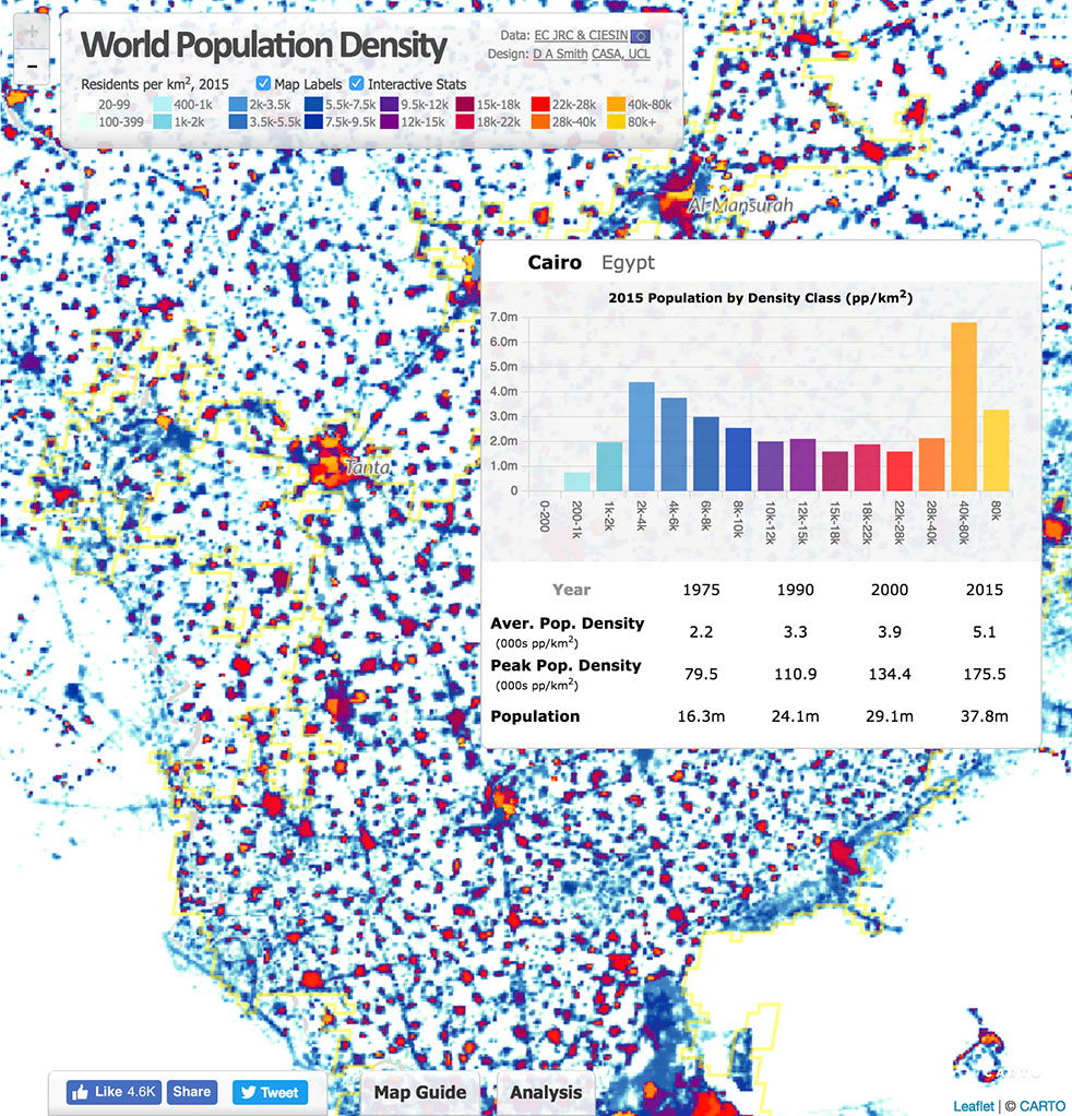
Since 1990, the urban population of Africa has doubled, with more than 80 percent of its denizens living in urban areas. Urbanization can contribute to sustainable growth, if managed well.
However, its speed and scale bring challenges, including meeting accelerated demand for affordable housing, transport systems, infrastructure, basic services and jobs.
Population data such as shown above is only a sample of the geospatial data available in Esri’s new Africa GeoPortal (www.africageoportal.com). The Esri-led initiative is a cloud-based platform that provides and receives geographic data and imagery from Esri and its partners.
The African Union, African Development Bank, other international agencies, nongovernmental organizations, academia, businesses and national government funds will be able to use the geoportal to address the most urgent development challenges facing the continent — including economic development, climate adaptation, conservation and health care.
The complimentary software-as-a-service geoportal is offered to anyone supporting African nations for positive economic, social and environmental outcomes — African citizens, NGOs and international development agencies. The geoportal offers access to spatial analytics capabilities and authoritative content for charting compelling, educational, informational, entertaining and beautiful maps of Africa.
The Global Human Settlement Layer from the European Commission’s Joint Research Centre (JRC) is a complete, consistent, global, free and open dataset on human settlements, and helps to quantify and understand the issues that drive urbanization. The above example comes from the JRC in its Esri story map “Building Knowledge for Sustainable Development in Africa,” which shows how the JRC contributes to the African Union (AU)-European Union (EU) partnership.
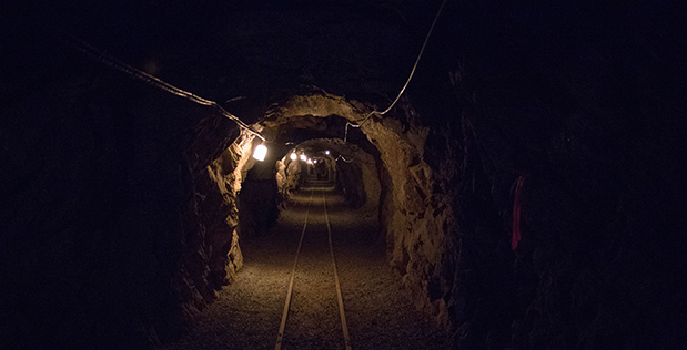
DARPA has issued a Request for Information (RFI) to augment its understanding of state-of-the-art technologies for 3D mapping and surveying. (Photo: DARPA)
Request for Information pursues state-of-the-art technologies for collecting and characterizing 3D mapping and surveying data.
DARPA is seeking information on state-of-the-art technologies and methodologies for advanced mapping and surveying in support of the agency’s Subterranean (SubT) Challenge.
Georeferenced data — geographic coordinates tied to a map or image — could significantly improve the speed and accuracy of warfighters in time-sensitive active combat operations and disaster-related missions in the subterranean domain. Today, the majority of the underground environments are uncharted or inadequately mapped, including human-made tunnels, underground infrastructure, and natural cave networks.
Through the Request for Information, DARPA is looking for innovative technologies to collect highly accurate and reproducible ground-truth data for subterranean environments, which would potentially disrupt and positively leverage the subterranean domain without prohibitive cost and with less risk to human lives. These innovative technologies will allow for exploring and exploiting these dark and dirty environments that are too dangerous to deploy humans.
“What makes subterranean areas challenging for precision mapping and surveying — such as lack of GPS, constrained passages, dark or dust-filled air — is similar to what inhibits safe and speedy underground operations for our warfighters,” said Timothy Chung, program manager in DARPA’s Tactical Technology Office (TTO). “Building an accurate three-dimensional picture is a key enabler to rapidly and remotely exploring and searching subterranean spaces.”
DARPA is looking for commercial products, software, and services available to enable high-fidelity, 3D mapping and surveying of underground environments. Of interest are available technologies that offer high accuracy and high resolution, with the ability to provide precise and reproducible survey points without reliance on substantial infrastructure (such as access to global fixes underground).
Additionally, relevant software should also allow for generated data products to be easily manipulated, annotated, and rendered into 3D mesh objects for importing into simulation and game engine environments.
DARPA may select proposers to demonstrate their technologies or methods to determine feasibility of capabilities for potential use in the SubT Challenge in generating and sharing 3D datasets of underground environments.
Such accurately georeferenced data may aid in scoring the SubT competitors’ performance in identifying and reporting the location of artifacts placed within the course. In addition, renderings from these data may provide DARPA with additional visualization assets to showcase competition activities in real-time and post-production.
Few commercial UAV operations would be able to inspect transmissions lines, pipelines or train tracks without beyond visual line-of-sight (BVLOS) capability, but these key pieces of infrastructure often situate close to or transit across population centers. Further, many population centers have airports and low-level air traffic. Any tools to keep drones away from air traffic during BVLOS operations will significantly inspection companies. We review three promising solutions here.
Pipeline Inspection
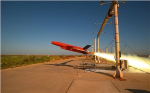
Kongsberg Geospatial in Ottawa, Canada has developed location visualization software tools that are used for air-traffic control, command and control, and air defense applications. The company has several decades of experience in these applications. Its IRIS software was used to support recent UAV oil pipeline inspection operations in Nigeria, providing safety critical airspace deconfliction, supervised by the Nigerian Civil Aviation Authority (NCAA).
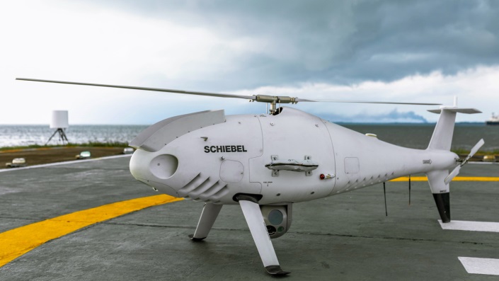
The pipeline project was undertaken by Aerial Robotix, a UAS services provider in Nigeria, who used adapted Kongsberg software in its control center to demonstrate safe BVLOS operations, and was then able to obtain the necessary permits. A Schiebel Camcopter S-100 UAV with a 200-kilometer BVLOS capability was used for flight inspection, operating both day and night, with real time high-definition payload imagery sent back to the control station.
Camcopter S-100 prior to BVLOS pipeline inspection flight in Nigeria. (Photo: Schiebel)
Nigeria has a major problem with gasoline theft from pipelines similar to those lines inspected during this project. Recently, 105 people perished in a blast from a ruptured pipe 30 miles north of the city of Umuahia, possibly during scavenging for leaking fuel. It has been claimed that the pipeline had been ruptured by saboteurs earlier, and for the following six weeks villagers had been collecting fuel. Pipeline vandalism is common in Nigeria, even given the risk of fire or explosion, or the risk of prosecution, or even the possibility of being shot on sight.
Unmanned Companion Fighter Aircraft
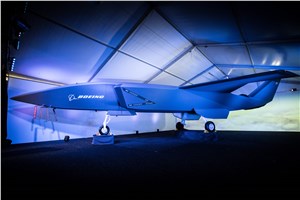
Boeing just unveiled a concept UAV which is apparently aimed at providing an airborne team-partner for manned aircraft.The concept was introduced at the Australian International Airshow by the Australian Minister for Defense, the Hon. Christopher Pyne MP. The project is slated for a significant R&D investment by the Australian Government and Boeing Australia.
Boeing Airpower Teaming System. (Photo: Boeing Company)Boeing Airpower Teaming System. (Photo: Boeing Company)
The concept model has fighter aircraft lines with a projected 2,000-mile range, autonomous capability, and significant intelligence, surveillance and reconnaissance sensor capability. Flying alongside manned fighter/attack aircraft with artificial intelligence simplifying control, the Airpower Teaming System is designed as a low-cost force multiplier.
The concept includes a pitch for international collaboration offering significant customization so countries can add local content, a key element for any aircraft program designed for off-shore sales.
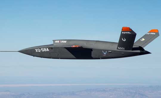
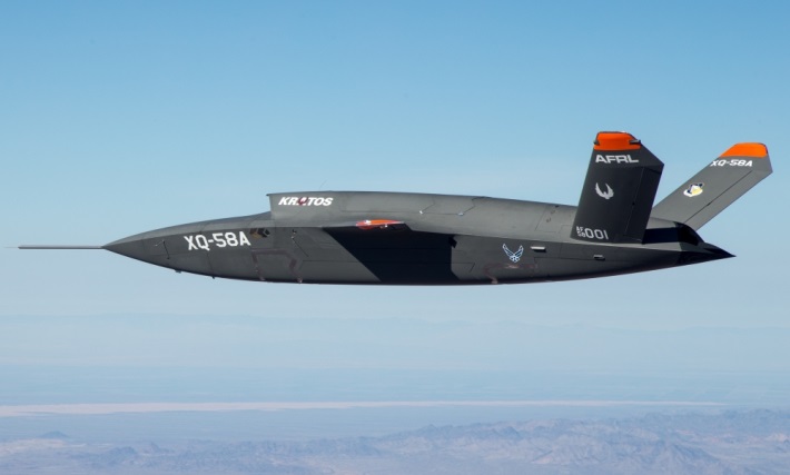
XQ-58A demonstrator in flight. (Photo: U.S. Air Force)
A day or so after the Airshow (maybe not wanting to be upstaged by Boeing’s announcement?) a release showed up about the first flight of the previously secret XQ-58A Valkyrie demonstrator. This is apparently a program by the US Air Force Research Laboratory (AFRL) partnered with Kratos Unmanned Aerial Systems to develop a UAS which looks to have very similar capabilities to that of the Boeing concept, perhaps at a significantly further advanced stage, with a much more mil-spec UAV sounding name.
The AFRL indicated that the XQ-58A is part of a Low Cost Attritable Aircraft Technology (LCAAT) (guess that means they don’t much mind losing a few) effort to come up with low-cost force multipliers which can be built quickly using commercial technology and operating from unprepared runways.
(From the Air Force: “The thought is to develop an inexpensive, configurable and producible on demand air vehicle. A number of military applications can be envisioned for an air vehicle with such a capability. One potential application is to use hundreds or thousands of such units in a campaign to overwhelm an enemy’s air defenses and “punch a hole” to enable higher value, less replaceable [aircraft] to engage or monitor enemy systems. Another potential application is to augment the capabilities of high-value intelligence, surveillance and reconnaissance, systems which may be limited in a specific campaign by distances, quantities, or threats. For all applications, the weapon system is expected to be an air vehicle that would return to base or to a separate location to be recovered. However, because of the mission and because of the low cost, the air vehicle would be attritable, meaning the Air Force would expect and could afford to lose many of the assets.”)
The current program took 2½ years to get to this flying prototype, which still seems pretty lengthy in terms of today’s commercial UAVs. The first flight from Yuma Proving Grounds in Arizona lasted an hour and a quarter and all went as expected. Five test flights are planned to check out functionality, aerodynamics, and launch and recovery systems. Kratos is perhaps better known for its family of target drones which have been in use by the US and internationally for some time.
Kratos BQM-177 Navy drone declared operational. (Photo: Naval Air Systems Command)
Kratos Defense & Security Solutions, Inc. announced in early March that its BQM-177A Subsonic Aerial Target (SSAT) has achieved Initial Operational Capability as reported by the US Navy. A Navy statement said “The first site the BQM-177A will be operated from is Pt Mugu, California. The target is capable of speeds in excess of 0.9 Mach and a sea-skimming altitude as low as 10 feet which provides sea-skimming anti-ship cruise missile threat emulation for the US Navy.”
Parachute System for DJI Phantom 4
Recent testing of the descent rate of a Phantom 4 equipped with a SafeAir parachute system indicated that this UAV/parachute combination may well meet the FAA’s recently published draft rules for flight over people. The parachute system uses on-board indicators to trigger parachute deployment. ParaZero (manufacturer of the SafeAir UAV parachute system) has developed standards, and promises to provide customers with certification data to support waiver applications for flight over people.
Wrap-up
So now we have intuitive software using terrain data and sensor inputs which can provide a visual overlay to supports BVLOS flights, concepts designs and prototypes to support the ‘Loyal Wingman’ approach – flying UAVs alongside existing defense aircraft as force multipliers – and advances towards UAV flight over people using certified parachute safety systems. Just a flavor of the flurry of recent new developments in the world of unmanned aircraft.
Check out a Nearmap high-resolution aerial image of Zions Bank Stadium/Real Academy. The solar was installed by Auric Solar. (Photo: Nearmap)
High-resolution aerial maps from NearMap are helping Auric Solar, a residential and commercial solar power provider, accelerate its initial site assessments, develop a more complete and accurate view of properties, and create winning proposals.
Auric accesses Nearmap imagery through the Aurora Solar platform, a solar sales and design software program. By utilizing Aurora software integrated with Nearmap imagery, Auric analysts have access to clear and current imagery. Headquartered in Salt Lake City, Utah, Auric services all of Utah, Idaho, Colorado and Oregon.
“Aurora’s responsive engineering interface coupled with Nearmap’s high-resolution captures allow us to use a combination of 3-D lidar models and 2-D high-resolution maps for complete accuracy in the planning and measuring stage of a project. This equips both the sales and analytics teams with accurate information to save time, money and serve the customer,” said Tyler Soukup, director of analytics at Auric Solar.
Analysts can make accurate measurements, run production numbers, identify roof obstructions and craft proposals all within the program. The sales team, analysts and installers are all on the same page, significantly reducing change orders.
The absolute horizontal accuracy of Nearmap’s georeferenced imagery is 0.75m (RMSE) or better. Measurements taken with Nearmap measurement tools are accurate to within 15cm for an individual photo. The company’s HyperCamera aerial photography system captures overlapping photographs along a flight path covering a survey area. Each photograph is tagged with its GPS location. Proprietary HyperVision technology then triangulates, orthorectifies and stitches these GPS-tagged photographs into a georeferenced photomap with an absolute horizontal accuracy of 0.75m (RMSE) and relative accuracy of 15cm. The process employs a combination of GPS positioning, high photo redundancy and triangulation of ground features to ensure this level of accuracy without the use of ground control points.
Solar panel installer Auric also has access to Nearmap historical imagery from years past, including leaf-on and leaf-off imagery, which presents the presence or lack of the foliage depending on the season. This greatly enhances shading analysis, making it easier to place the panels for maximum sun exposure. The company not only saves a significant amount of time with fewer onsite visits to qualify homes, but it also opens up more customers to solar.
“We’ve been able to qualify more customers than ever because of Nearmap’s clear, current captures. You really can’t accurately qualify a property without up-to-date imagery,” notes Soukup. “We quote projects from $20,000 to a few million dollars, and our proposals, plans and marketing materials should match that level of value. Nearmap helps us create a ‘wow’ factor.”
Before using Nearmap aerial imagery, Auric used using low-resolution satellite imagery to qualify properties. With outdated, blurry imagery, it was difficult to make accurate measurements and qualify a home before sending a technician for an on-site assessment.
Polaris Wireless, a provider of software-based wireless location solutions, announced the commercial availability of a high-accuracy carrier-independent 3D location platform for application developers. By integrating their applications to the new platform, developers can provide end users with pinpoint location, including indoors and in high-rise buildings with floor level accuracy, delivering enhanced situational awareness and improved operational efficiency, according to the company.
Polaris Wireless has integrated its new platform with Orion Labs, Inc., a San Francisco-based company delivering instant and secure voice and location communication.
The Polaris Wireless 3D location platform is cloud-based and is available to application developers via a standard Android and iOS SDK. It can locate devices on the vertical axis within 3 meters, floor level, utilizing all available signals and sensor measurements combined with the company’s patented algorithms. By operating independently, or “over the top,” of wireless carrier networks, the platform is “universal,” enabling applications to locate any device on any network.
“Orion’s customers in hospitality, retail, healthcare, and public safety require pinpoint accuracy on a person’s location inside a building. Polaris Wireless’ platform helps us deliver that location capability, both for teams to see which floor they’re on or room they’re in, as well as to integrate location awareness with Orion Voice Bots and advanced AI-driven services,” said Jesse Robbins, Founder and CEO of Orion Labs.
Orion will demonstrate its solution based on the Polaris Wireless 3D location platform at the International Wireless Communications Expo (IWCE) in Las Vegas March 4-8 in booth No. 3371.
Polaris Wireless CEO, Manlio Allegra, will be participating in an IWCE panel titled “Impact of Enhanced Location Accuracy on Public Safety and 911 Services” on Wednesday, March 6 at 11:45 a.m.
TCarta Marine, a global provider of geospatial products and services, has been contracted by the United Kingdom Hydrographic Office (UKHO) to provide a baseline dataset of water depths and seafloor classification around the Republic of Kiribati.
Located in the Pacific Ocean, the island nation is threatened by rising sea levels.
“Most of Kiribati’s islands average less than two meters above sea level at present and the country’s 110,000 inhabitants are among the most vulnerable to the effects of sea level rise and the world’s first potential climate change refugees,” said Kyle Goodrich, TCarta president.
“We expect to map 5,000 square kilometers in total. Our seafloor maps will be used with other geospatial information by the UKHO to recommend policies that will assist the Kiribati in planning for and responding to this situation,” Goodrich said.
TCarta won the open bid for supply of Satellite Derived Bathymetry (SDB) to the UKHO to extract water depth measurements and seafloor classifications, including habitat types, from multispectral satellite imagery.
In this project, TCarta is processing eight-band DigitalGlobe WorldView-2 and -3 data predominantly, as well as four-band WorldView-4 and GeoEye-1 data to measure depths down to 30 meters at a resolution of two meters.
“The Kiribati project highlights the efficiency and cost effectiveness of SDB technology in a geographic area too remote and enormous for traditional marine or airborne survey methods,” Goodrich said.
The Kiribati nation is comprised of 33 atoll islands and multiple reefs spread over an area of the Pacific Ocean nearly the size of the Continental U.S. Multiple new reefs have been discovered by TCarta using this satellite derived approach at the start of this project.
The islands and surrounding environs have not been mapped in their entirety since the late 1800s. Acquiring bathymetric data and habitat classifications using traditional ship-borne sonar or airborne lidar are prohibitively expensive, logistically challenging and come at far higher cost and timeframe than a satellite-based solution.
“We began tasking the DigitalGlobe satellites to capture images in December and will deliver the final products to the UKHO in early March,” said Goodrich, “DigitalGlobe has been a tremendous partner in helping TCarta meet the project deadlines and challenging open ocean conditions with repeat tasking of imagery, collecting more than 300 images in support of the project, despite the loss of WorldView 4.”
TCarta has developed advanced bathymetric measurement technologies using satellite data. Funded by the National Science Foundation SBIR Phase I grant and known as Project Trident, this new technology is being deployed in the Kiribati project to remotely validate the bathymetry results.
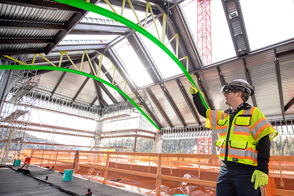
Trimble is offering a wearable hard hat compatible device that enables workers in safety-controlled environments to access holographic information on the worksite — the Trimble XR10 with HoloLens 2.
In addition, an expanded set of Trimble software and services will be available to provide field-oriented workflows that leverage constructible 3D models and mixed reality to solve daily work tasks.
The announcement was made with Microsoft at MWC Barcelona (formerly Mobile World Congress), being held this week.
The Trimble XR10 with HoloLens 2 is the first device created with the Microsoft HoloLens Customization Program and integrates the latest spatial computing technology into a certified solution for use with a hard hat for worker safety.
Photo: Trimble
With a wider field-of-view, improved usability and a unique, flip-up viewscreen, the Trimble XR10 with HoloLens 2 combines state-of-the-art mixed reality and safe operation in restricted access work areas.
The full solution provides even greater accessibility to 3D models by front-line workers. Field-oriented workflows enable broad adoption of mixed-reality for jobsite activities to improve efficiency, productivity and quality of work. Continued development of the cloud-based collaboration platform, Trimble Connect for HoloLens, is enabling workers in the field to get more value from constructible 3D models and transform daily work such as assembly and inspections.
“Microsoft has provided both the vision and execution needed to stay at the forefront of the mixed-reality evolution,” said Aviad Almagor, director of Trimble’s Mixed-Reality Program. “We’re excited to extend our collaboration with Microsoft in producing a safety-first mixed-reality solution that can be used in production environments such as construction, where workers are building, monitoring and inspecting products and services that deliver tangible value every day.”
“The ability to access and interact with holographic content has inspired new visualization, collaboration, and production workflows in enterprise markets,” said Alex Kipman, technical fellow, AI and Mixed Reality at Microsoft. “For people that spend their days on the work site, the Trimble XR10 with HoloLens 2 and Trimble’s portfolio of software unlocks the power of mixed-reality to help them get more work done.”
By Daniela E. Sánchez, Harvey C. Gómez and Thomas Pany, Institute of Space Technology and Space Applications (ISTA)
This paper presents how our system, consisting of a GNSS receiver antenna, an inertial measurement unit (IMU) and a lidar, is used to obtain high-precision maps through the geo-referencing of lidar point clouds. An accuracy assessment of the system is conducted, which also gives us insights on the quality of lidar range measurements for autonomous driving applications.
The assessment is done by geo-referencing the obtained point clouds of extracted buildings and comparing them against a supporting measuring system like a total station. The building extraction is done by performing an approximation of the mathematical model of a plane to the facades that composes the building in both, the lidar and the supporting measurement system data.
The paper also indicates the proposed pose determination method of a mobile agent using lidar data. Thanks to the advantages of active, 3D sensors, diverse objects in the environment can be detected as individual point sets, or clusters. Each of the segmented objects can be used as a landmark to figure how the agent is located with respect to those structural elements. The algorithm is capable of detecting the clusters in one point cloud, and finding the most alike point set on a subsequent scan. This is achieved by comparing global descriptors for point cloud data.
The Ensemble of Shape Functions (ESF) is selected as the cluster descriptor. The cluster matching is performed by comparing the clusters one-to-one, calculating the minimum Chi-squared distance among their descriptors. The smaller this distance, the greater the probability of being the same cluster in distinct epochs.
Figure 2. Direct geo-referencing of lidar data at different times. (Image: Authors)
The resultant cluster correspondences for the whole point cloud allow finding the rigid transformation between the point clouds. An initial coarse alignment among the clouds based on the centroids of each matched cluster was performed, followed by a fine alignment in order to reduce errors by the use of the Iterative Closest Point (ICP) algorithm. This approach is valid for urban environments, or for those where many objects can be segmented as clusters.
Finally, a practical case is described in order to show how we plan to use the outcome of the highly precise geo-referenced point clouds and the pose estimation method using lidar.