Because of overwhelming interest in the Pegasus:Two Mobile Mapping Contest, the Leica Geosystems Mobile Mapping team has announced an extension of the contest deadline. Entrants now have until August 31, 2014, to submit their detailed proposals and project timelines.
“We are very excited about the interest shown in the Pegasus:Two mobile mapping solution and the resulting enquiries into the contest,” says Stuart Woods, project manager at Leica Geosystems. “Extending the contest deadline provides potential entrants with more time to create and prepare their entries. There are many fantastic ideas developing throughout the world and we’re extremely curious to learn about them.”
The winner of this contest, who will receive free use of a Leica Geosystems’ Pegasus:Two mobile mapping system for six months plus $10,000 USD to spend on the project, will be announced on September 8.
Steven Spriggs was pulled over by a motorcycle cop for using his iPhone while driving. He immediately held it up to show the officer that he was using Apple Maps, and not talking or texting. More about Mr. Spriggs later. With approval of the pending transportation bill in Congress, smartphone maps and navigation will be regulated. The National Highway Traffic Safety Administration (NHTSA) would receive the power to regulate apps like Google Maps or Apple Maps. NHTSA’s job would be to review navigation apps and order changes to decrease driver distractibility.
Guess who is in favor of this new regulation for smartphone apps? Automakers. Embedded navigation systems, those found in the dashboard of vehicles, are already regulated by NHTSA. Smartphone navigation apps are a much cheaper option than the systems offered by automakers, who are looking for a more level playing field and a way to slow down the smartphone navigation juggernaut.
The downside to this regulation is big. If it was just Apple and Google mapping, oversight would be simpler, but Apple App Store and Google Play Store are filled with hundreds of mapping and navigation apps. Logistically it doesn’t seem possible for the NHTSA to review all of the apps efficiently without causing interference in the market. NHTSA doesn’t currently have the budget, infrastructure or staffing to be successful.
The forum of the radio show “Car Talk” is alive with discussion on NHTSA’s desire to control navigation. The vast majority of posters point out the distraction from using a paper map or being lost. “Personally, I prefer a full-sized road atlas on the seat beside me for all my navigation needs. Taking occasional readings with a sextant helps, but is difficult while eating my Big Mac and holding the wheel with my knee,” Paul Carney writes with sarcasm. On the other side, Victor Cooper responds, “YES! It is long overdue. And I think it is about time we treat texting while driving the same as we do drunk driving…criminal penalties and all.”
I think regulation on mapping and navigation may help make the apps simpler to use and less distracting. Before passing a regulatory law, I’d like NHTSA to successfully demonstrate a review system that doesn’t impede innovation, significantly delay new products, or make it overwhelming difficult for small start-ups.
So what happened to Steven Spriggs? The police officer went ahead and wrote a $165 ticket for using a cell phone while driving, despite Spriggs argument that the law didn’t apply to navigation apps. Spriggs challenged his ticket in California’s state appeal court and won. The $165 went back into Spriggs’ pocket and map users everywhere sighed with relief,
Eagle Mapping Ltd., a North American digital airborne mapping company, is now using the new Riegl LMS-Q1560 airborne laser scanner system. Designed to capture ultra-wide swaths and complex environments, the high-performance Riegl LiDAR will enable Eagle Mapping to expand into new markets including large-area, forestry and urban mapping applications for governments and first-nation organizations.
“The Riegl LMS-Q1560 is a powerful laser scanner developed to acquire data over large geographic areas at high altitudes,” said James Hume, Eagle Mapping President. “This will allow us to map expansive cities, counties and tribal lands quickly and cost effectively.”
Riegl designed the powerful dual-channel LMS-Q1560 laser scanner with integrated medium-format camera for a variety of airborne mapping projects with an emphasis on wide-swath coverage. With a 58-degree field of view, the laser can be operated at a maximum pulse repetition rate of 800 kHz capable of measuring 530,000 points per second on the ground from an altitude up to 15,500 feet AGL.
“The Riegl LMS-Q1560 is the most cost-competitive airborne laser scanner on the market today,” said Hume. “We can fly at a higher altitude and collect a denser spacing of elevation data than any other LiDAR system out there.”
In addition, the Riegl LMS-Q1560 has a forward-and-look capability which, when combined with its wide field of view, enables the device to capture data from multiple angles effectively and accurately at an extremely high point density. The sensor also utilizes Multiple-Time-Around processing, echo digitization and waveform analysis to simultaneously track more than 10 pulses in the air.
This means the LiDAR can collect tightly spaced elevation points even in complex environments. Examples are built-up city centers with a variety of buildings and vertical structures, as well as extremely rugged mountain terrain where elevations change dramatically and abruptly.
“Whether working in the mountains of British Columbia or over a densely developed urban center, we will capture accurate elevation points between soaring peaks as efficiently as we do between high-rise office buildings,” added Hume. “And regardless of the terrain, we’ll collect more data in a day and finish jobs faster than we could before.”
Over nearly three decades, Eagle Mapping has built its reputation on finding more accurate and affordable mapping technologies. Focusing primarily on the global mining industry, the Vancouver firm was among the first to deploy airborne LiDAR technology for mapping. More recently, the Canadian firm configured a high-density, narrow-swath Riegl VQ-580 LiDAR with a DiMAC medium-format camera on a single aircraft to simultaneously collect elevation and image data for efficient mapping of pipeline and transmission line corridors.
“As we expand into urban and large-area projects for government clients, we will continue to support our extensive client base in the international mining and corridor mapping markets,” said Rodney Cope, vice president of sales and marketing.
Eagle Mapping operates a Cessna 206 and Piper Navajo aircraft based in British Columbia. The Navajo carries the new Riegl LMSQ1560, and the Cessna is equipped with the Riegl VQ-580 LiDAR and DiMAC digital camera. The firm maintains field offices in Bellingham, Washington, USA, and Medellin, Colombia, in South America.
Tree crowns above 1m2 are extracted, then a Soil Adjusted Vegetation Index (SAVI) is applied to provide an indication of tree health. Green indicates a healthy tree, red indicates a less healthy tree (within the Abu Dhabi forest plantations). So far this process has been applied to over 4,000,000 trees in Abu Dhabi.
Proteus FZC, a provider of satellite-derived mapping and classification services, has completed a demonstration project using satellite imagery to inventory tree plantations in the Emirate of Abu Dhabi. The tree mapping pilot is a spin-off of a larger Emirate-wide habitat and land use/land cover (LULC) project now being spearheaded by Proteus.
In the pilot, the Proteus team processed multispectral data collected by DigitalGlobe’s WorldView-2 commercial imaging satellite to identify the species and conditions of individual trees within the pilot area. Proteus managed the project, in which GMV of Spain performed image processing and automatic tree extraction with local ground-truthing support from Nautica Environmental Associates in Abu Dhabi.
“This pilot demonstrates the viability of using very high-resolution multispectral data to establish a baseline inventory of tree type and health within diverse forest plantations,” said Proteus Project Manager, Richard Flemmings. “We mapped every tree crown larger than one meter in diameter in the pilot area with minimal ground truthing and delivered the results in an Esri geodatabase.”
Abu Dhabi has planted forest plantations totaling nearly 20 million trees that provide aesthetic and environmental benefits throughout the Emirate. Comprised of gaff, acacia, mesquite and other species, these plantations require continuous irrigation with desalinated water at considerable expense. The Environment Agency — Abu Dhabi (EAD) — requested the pilot as it seeks to find an efficient and cost-effective way to monitor the forest stands.
“These forest plantations are valuable resources for Abu Dhabi,” said Flemmings. “EAD envisions a monitoring program that identifies isolated health problems so they can be remediated.”
Proteus applied image processing techniques using all eight WorldView-2 multispectral bands plus one panchromatic band, with an emphasis on the mid-infrared spectra. This multi-step processing distinguished several tree species by their individual canopies and detected stress, possibly related to irrigation, salinity or infestation issues, in some of the trees.
Compared to the traditional ways of monitoring forestry plantations in the area, which implies walking along the tree lines to detect damaged/dead trees, remote sensing offers a cost-effective alternative.
“We used pan-sharpened imagery to create the baseline plantation map, but less expensive lower-resolution imagery such as Landsat could be used for ongoing periodic monitoring,” said Flemmings. “This individual tree mapping technique can be applied to create forest inventories of other species elsewhere in the world.”
Aside from the tree plantation pilot, Proteus is engaged in a fine-scale satellite-derived terrestrial and marine LULC and habitat mapping project for the entire Emirate of Abu Dhabi. The three-phase, multi-million dollar project will ultimately include 60,000 sq. km. of land area and the coastal marine environment down to the 15-meter contour. Advanced processing algorithms are being used to extract LULC and habitat features from high-resolution multispectral satellite imagery acquired over both land and sea. Tree plantations are one of the LULC types identified by the Proteus team in the larger EAD project.
In the coastal Arabian Gulf, Proteus is delivering seabed classifications to depths of 15-20 meters. Deliverables for each phase of the Abu Dhabi mapping project include bathymetric analysis, orthorectified mosaic, LULC/habitat ecological classifications, geospatial models, printed maps at multiple scales, and knowledge transfer.
Since 2011, Proteus has been delivering solutions for mapping and classification projects using multispectral satellite imagery. These mapping projects have been delivered for environmental, oil & gas, engineering and other coastal zone applications in Europe, the United States, the Middle East, and the Caribbean.
Trimble has introduced a new version of its office software suite used by surveyors and geospatial professionals for processing and analyzing geospatial data. Trimble Business Center Version 3.21 introduces new coordinate reference systems and a specialized Advanced Drafting module, which enables faster project turnaround and better decision making.
The optional Advanced Drafting module adds highly customizable templates and simplified selection tools, which are designed to reduce the time required to generate high-quality deliverables, such as geospatial maps and corridor cross-sections. Now, professionals working on road, pipeline, and railway projects can achieve efficiency gains through the software’s new automated cross-section plotting functionality.
Also included in the new module is the ability to create 3D PDFs so that team members and clients can collaborate from any computer or mobile device using Adobe Reader software.
“Trimble Business Center is the enterprise solution for surveyors and geospatial professionals to produce high-quality deliverables,” said Alain Samaha, business area director of GIS and Software for Trimble’s Geospatial Division. “These new capabilities demonstrate the continued evolution of our software portfolio to provide customers with an end-to-end solution to fulfill their client’s high-end requirements in the most efficient way.”
Trimble is offering a new agronomic service that is part of its Connected Farm solution. The new service, Soil Information System (SIS), provides farmers and their trusted advisors with in-depth 3-D soil data they can use to make more informed decisions about their crop production goals.
The SIS data is accessed through Connected Farm and can be used with Trimble’s Farm Works farm management software or other GIS platforms. Connected Farm enables better decision making by providing one central location for accessing key information impacting farm operations such as rainfall totals, weather forecasts, commodity tracking, planting coverage, yield mapping, fleet management, and irrigation monitoring and control, Trimble said.
The SIS 3D soil mapping technology uses advanced sensors along with intelligent targeting and geoprocessing algorithms to produce high-resolution, accurate soil and topographic information. By providing a greater understanding of the physical and chemical characterization of the soil, including how inputs move through the soil, SIS enables farmers to initiate more effective solutions to resolve the unique challenges of each area of their fields. The SIS solution outputs precise, multi-layer soil models that are more comprehensive than traditional methods used in the industry today. Some examples of map types include: root zone depth, soil texture, plant available water, compaction depth, macro and micro-nutrient levels, soil nutrient holding capacity, and salt and toxicity concentrations.
By analyzing soil variability and patterns prior to sampling — and by using its industry-exclusive data acquisition and analysis software — SIS provides targeted recommendations on the best locations where soil samples should be taken. In some cases this reduces the number of samples required to provide high-quality information by as much as 60 percent over traditional sampling methods. As a result, the solution enables agronomists to be more efficient with in-field data collection, providing valuable time and operating cost savings.
“By adding the Soil Information System solution to Connected Farm, Trimble is providing farmers and their agronomists with critical soil information they can use to improve crop production and benefit the bottom line,” said Levi Kettle, Connected Farm business area director of Trimble’s Agriculture Division. “For example, knowing the soil’s plant available water capacity can aid in irrigation layout, scheduling, moisture sensor targeting, root stock selection and many other management decisions.”
“Variability in yield and quality are due primarily to non-uniform soils being managed as uniform soils. In the past, our inability to identify the components of this soil variability prevented us from achieving greater crop uniformity and better economic returns,” said Robert Wample, Ph.D., a plant physiologist and owner of Edgeknoll Consulting, an SIS service provider. “SIS allows us to take a proactive approach to overcoming soil variability, and when combined with geo-referenced variability in crop yield and quality, the effectiveness of this approach is enhanced even more resulting in an ‘agricultural forensics’ approach to precision agriculture.”
The SIS solution is available in several service levels depending on the accuracy and resolution required for the particular crop type and the grower’s production goals.
Jack Dangermond, founder and president of Esri, has announced that Esri will make its advanced mapping software ArcGIS available for free to K-12 schools across the country, reports FORBES. Through the program, students will have access to the same cloud-based GIS technology used by governments and businesses to map and analyze data. The program is set to benefit more than 100,000 schools, with each ArcGIS online account worth about $10,000, adding up to a total potential value exceeding $1 billion, according to Esri.
“This is not a new endeavor by us. We have been supporting GIS in schools for more than 25 years,” Dangermond told FORBES. “Bringing GIS into schools gets the kids very excited and indirectly teaches them different components of STEM education. That’s been illustrated at school after school.”
The idea began when Dangermond met with President Obama a few months ago to discuss how Esri can contribute to the ConnectED Initiative, a program by the White House to help strengthen STEM education for K-12 students. “I asked myself: ‘What’s the biggest idea that we can go for?’” Dangermond recalled. As soon as he proposed that Esri would offer its software for free for every K-12 school in America, the president was immediately on board. “We thought this is a way to scale it up and bring GIS education to schools in the whole country,” Dangermond said.
Esri previously experimented with the initiative on a smaller scale in different states. In Detroit, students used the company’s software to identify environmental issues and come up with plans to fix them. Students also have used ArcGIS to map health issues in Los Angeles and use demographic data to get Walmart products delivered to returning veterans.
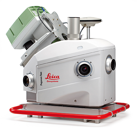
Leica Geosystems has introduced its next generation vehicle-independent mobile mapping platform, the Pegasus:Two. By calibrating imagery and LiDAR point cloud data, the Pegasus:Two delivers highly accurate and economical geospatial data in a 360° spherical view while providing two methods for extracting data — either through LiDAR or via photogrammetry.
With its enhanced sensor platform using six horizontal cameras, plus an optional rear camera and a skyward view camera, a single high-speed LiDAR sensor, and an external output for an additional sensor, the Pegasus:Two enables unlimited mobile mapping applications, from pavement analysis to geo-referencing railways systems, now possible within the same platform, the company said.
From hardware to post-processing, Pegasus:Two allows economic data collection by balancing the largest pixel to sensor ratio on the market (5.5 x 5.5 µm), delivering extremely high image resolution, in a 4-MB camera and using a single low-noise, high-speed profiler. Users can download data via Wi-Fi or wired Ethernet, or even faster by using the latest USB3 interface, by means of a multi-core, industrial PC with 1-TB storage and a solid state drive, enabling longer missions. An optional rotation mount, designed specifically for the Leica ScanStation P20, also makes mounting the terrestrial scanner upside down or right side up while also enabling left or right rotation.
The Pegasus:Two in its new streamlined housing with aerodynamic design.
Expanding on the success of Leica Geosystems’ mobile mapping software, the latest software now offers semi-automatic object extraction features, which enable easy-to-use two-click GIS metadata extraction or calculation of distances on-the-fly directly into ArcGIS for Desktop software.
Leica Geosystems also introduces an external timing output and trigger signal for use with a variety of additional sensors, from a thermal camera, to ground penetrating radar, sonar, or even a pollution monitor. The External Trigger feature synchronizes time stamping and coordinates user data with one simple click, making 3D mobile mapping very user-friendly.
Urban canyons. Equipped with the NovAtel’s ProPak6 high-precision receiver for the most demanding city or rugged environments, the Pegasus:Two offers users a truly global system. It is a future-proof investment that tracks signals of all available constellations, GPS, GLONASS, Galileo and BeiDou as well as L-band, SBAS, and QZSS band coverage to ensure the best signal even when moving through urban canyons. The system provides a low noise, 200hz Inertial Measurement Unit for tracking the vehicle path thereby ensuring data is positioned accurately.
Aerodynamic design. The Leica Pegasus:Two mobile mapping system now comes with a new streamlined and compact look and continues to fit in only two travel cases. A convenient handle surrounding the unit enables easy mounting on and off your vehicles. The Pegasus:Two is a vehicle-independent system with a rechargeable 11 hour battery, and can be used on any moving platform.
“The Leica Pegasus:Two platform is a unique complete solution,” said Stuart Woods, vice president for Leica Geosystems Geospatial Division. “By providing software and hardware designed to seamlessly work together, users not only receive the latest in mobile mapping technology but also optimal performance and faster workflows. By keeping the platform vehicle independent and adding new sensor options, we encourage our customers to find new ways, to try out different sensors, new revenue models, and new places to measure. ”
Along with the Pegasus:Two, the advanced prototype, Pegasus:T2, a trolley based mobile system weighing less than 20 kilograms will also be on display at the HxGN LIVE 2014 Conference in Las Vegas.
AT&T’s Network Disaster Recovery (NDR) program, as the first private company certified by the Department of Homeland Security for private-company voluntary disaster preparedness, is committed to maintaining and restoring the AT&T global network when natural disasters strike, the company said.
Despite predictions, no one is certain when the next tropical storm or hurricane will ravage the coastline. With $600 million invested in the NDR program, AT&T’s arsenal of equipment includes more than 320 technology and equipment trailers that can be quickly deployed, making it one of the nation’s largest and most advanced disaster programs.
“Staying connected during severe weather events is critically important to consumers, businesses and our emergency management officials,” said Sonia Perez, president, AT&T Louisiana. “That’s why AT&T invests a tremendous amount of resources in our network reliability and disaster response capabilities.”
The Network Disaster Recovery team works closely with other AT&T response teams, local AT&T network personnel, regional Emergency Operations Centers and Local Response Centers to fortify network facilities and equipment, and stage technicians and resources near the storm impact area. In the event of damage, teams are poised to restore and maintain service until permanent repairs can be made.
AT&T also conducts readiness drills and simulations throughout the year to ensure its networks are prepared and its personnel are ready to respond at a moment’s notice. Since its inception in 1991, the NDR has responded to more than 20 catastrophes across the U.S.
Response equipment readied in the wake of an event includes:
Mobile cell sites and mobile command centers
Emergency communications vehicles
A self-sufficient base camp, complete with sleeping tents, bathrooms, kitchen, laundry facilities, on-site nurse and meals ready to eat (MREs)
Hazmat equipment and supplies
Technology and support trailers to provide infrastructure support and mobile heating ventilation and air conditioning
Internal and external resources for initial assessment and recovery efforts.
Consumers and businesses also should have a plan in place. When preparing for an evacuation or shelter-in-place, remember these tips:
Keep your wireless phone batteries charged at all times. In case of a power outage, have alternate means of charging your phone available, such as an extra battery, car charger or device-charging accessory. Sales tax holidays are a great time to stock up on cell phone accessories for your household.
Keep your wireless phone dry. The biggest threat to your device during a hurricane is water, so keep your equipment safe from the elements by storing it in a baggie or some other type of protective covering, such as an Otterbox phone cover.
Have a family communication plan in place. Designate someone out of the area as a central contact, and make certain that all family members know who to contact if they get separated. Most importantly, practice your emergency plan in advance.
Forward your home number to your wireless number in the event of an evacuation. Because call forwarding is based out of the telephone central office, you will get incoming calls from your landline phone even if your local telephone service is disrupted at your home. In the unlikely event that the central office is not operational, services such as Voicemail, Call Forwarding, Remote Access call forwarding and call forwarding busy line/don’t answer may be useful.
Track the storm and access weather information on your wireless device. Many homes lose power during severe weather. If you have a working wireless device that provides access to the Internet, you can watch weather reports through services like AT&T U-verse Live TV or keep updated with local radar and severe weather alerts through My-Cast Weather, if you subscribe to those services.
Take advantage of location-based mapping technology. Services such as AT&T Navigator and AT&T FamilyMap can help you seek evacuation routes or avoid traffic congestion from downed trees or power lines, as well as track a family member’s wireless device in case you get separated.
Keeping the lines open for emergencies
During evacuations, the storm event and its aftermath, network resources will be taxed. To help ensure that emergency personnel have open lines, keep these tips in mind:
Text messaging. During an emergency situation, text messages may go through more quickly than voice calls because they require fewer network resources. All of AT&T’s wireless devices are text messaging capable. Depending on your text or data plan, additional charges may apply.
Be prepared for high call volume. During an emergency, many people are trying to use their phones at the same time. The increased calling volume may create network congestion, leading to “fast busy” signals on your wireless phone or a slow dial tone on your landline phone. If this happens, hang up, wait several seconds and then try the call again. This allows your original call data to clear the network before you try again.
Keep non-emergency calls to a minimum, and limit your calls to the most important ones. If there is severe weather, chances are many people will be attempting to place calls to loved ones, friends and business associates.
Small Business Tips:
Set up a call-forwarding service to a predetermined backup location. Set up a single or multiple hotline number(s) for employees, employees’ families, customers and partners, as appropriate, to call so that all parties know about the business situation and emergency plan.
Back up data to the Cloud. Routinely back up files to an off-site location. Services such as Mobile Workplace are a suggested solution for small businesses.
Outline detailed plans for evacuation and shelter-in-place plans. Practice these plans (employee training, etc.). Establish a backup location for your business and meeting place for all employees.
Assemble a crisis-management team and coordinate efforts with neighboring businesses and building management. Be aware that disasters affecting your suppliers also affect your business. Outline a plan for supply chain continuity for business essentials.
Consider a back-up cellular network. Services like AT&T Remote Mobility Zone, allows organizations to protect their critical communications by installing small cell sites at the businesses’ locations. If a disaster disables primary communications networks, the back-up cellular network can help keep your company connected.
In 2013, Lehmann Aviation launched the LA300 — a fully automatic personal drone working with Nokia Lumia 1020 and Windows 8 Tablet and designed for mapping and DEM.
Flight tests in May have proven compatibility of the GoPro Hero3+ camera, in addition to Nokia Lumia 1020 41-Mp camera, with the LA300 for orthomosaics and digital elevation models (DEM), which makes this drone the an affordable and easy-to-use professional rugged solution for mapping and surveying, Lehmann Aviation said.
LA300 is a fully automatic professional UAV designed for accurate mapping and surveying. To get the geo-referenced orthomosaics or DEM, the user needs to take three simple steps (watch the video below):
Step 1: Download the free Lehmann Aviation software — Operation Center — to any Windows 8 Tablet, Windows Phone 8, or PC. Step 2: Make the flight path by drawing on a touchscreen Windows 8 device the area of interest (on the map) and entering the waypoints, after which the software will automatically generate the mission. Step 3: Transmit the data to the drone by Wi-Fi, launch it by hand, and wait until the aerial robot returns to any chosen point with HD images or video on the SD card. Step 4: Use Operation Center to geotag each image after the flight, with LAT/LONG/ALT/YAW/PITCH/ROLL information.
The pictures then can be processed in any popular orthomosaic/DEM software to generate professional orthomosaics and 3D models.
The drone flies at a range of up to 15 km, at speeds of 20-80 km/h. It can be flown in harsh environments, between -25 °C up to +60 °C (-13 °F up to 140 °F), with winds up to 35 km/h (20kt). The LA300 weights 950 grams (including Nokia Lumia 1020 or GoPro Hero3+ camera), with a wingspan of 92 cm and the length of 45 cm. The drone is launched by hand and lands in a few meters of space.
All Lehmann Aviation drones come with one-year warranty and can be regularly upgraded to newer versions.
Earth observing satellites are generating big data sets — Really Big!
I’m stepping in just for this month as a self-invited guest columnist, giving a brief look at the trailblazing work of the International Centre for Earth Simulation.
Look for both Eric Gakstatter and me at the ESRI User Conference in July, where Eric will also host a webinar on the hottest trends in mapping. We hope to accommodate a live audience at the webinar. If you’re not attending ESRI, attend the webinar anyway! For a top-level look at conference doings, register free.
In easily the most mind-blowing presentation of the Geospatial World Forum held recently in Geneva, Bob Bishop of the International Centre for Earth Simulation spun a vision of Big Data Earth Science, using the world’s largest computing resources (talk of exoflops and exobytes and “the human mind cannot comprehend these large volumes of data” supplied by many orbiting imagery satellites and other sensor inputs) to model the Whole Earth: surface, subsurface, ocean, atmosphere, and social economics.
The Centre’s mission is “Helping guide the successful transformation of human society in an era of rapid climate change and frequent natural disasters.”
In its prospectus, Bishop writes “The key to solving problems in weather, climate and environmental science is high-performance computing. Nature can only be accurately described and computed from equations that take account of complex, non-linear interactions between multiple natural systems, i.e. rivers, lakes, oceans, mountains, forests, dust, pollution, cloud cover, snow cover, ice, polar regions, etc. Such equations of motion are so interconnected and intertwined that they can only be managed when all aspects are held in big memory and computed simultaneously. Only then can we begin to address the systemic risks associated with natural disasters and planetary change.”
The ICES Foundation supports Open Science, which incorporates a combination of open data files, open source code, and open access publications. Much of the data supplied by the following organizations, upon whose resources ICES draws, is either directly produced by or referenced to GPS/GNSS data: Global Observing Systems Information Center and the U.S. National Oceanic and Atmospheric Adminisration; the European Space Agency and Centre for Space Records; the U.S. Geological Survey; the U.S. National Aeronautics and Space Administration; the European Union’s Joint Research Center; the U.S. National Center for Atmospheric Research; the U.S. Naval Research Laboratory; the European Commission’s Infrastructure for Spatial Information in the European Community (INSPIRE); and many more.
Slides from Bishop’s Geneva presentation are available here. These, however, of necessity lack some of the video and Flash Player simulations that he showed at the conference, revealing truly a dynamic planet in all aspects.
Bishop warned of both sequential and synchronous collapse of natural systems, leading to cascading crises. His language and message bear some resemblance to Al Gore’s An Inconvenient Truth, but Bishop, whose previous 40-year professional career had him responsible for building and operating the international aspects of Silicon Graphics Inc., Apollo Computer Inc., and Digital Equipment Corporation, has assembled some actual practical tools to apply to the many problems.
The immediate goal is modeling, simulation, visualization, and ultimately understanding of the whole, leading to new forms of civic engagement and insights as to risk, safety, food, water, and energy.


 The drone flies at a range of up to 15 km, at speeds of 20-80 km/h. It can be flown in harsh environments, between -25 °C up to +60 °C (-13 °F up to 140 °F), with winds up to 35 km/h (20kt). The LA300 weights 950 grams (including Nokia Lumia 1020 or GoPro Hero3+ camera), with a wingspan of 92 cm and the length of 45 cm. The drone is launched by hand and lands in a few meters of space.