March 6, 2014 update: On March 6, 2014 Federal Judge Patrick Geraghty ruled against the FAA in its case against Rapheal Pirker, opening up commercial use of drones in the U.S.
Forgive me for circling back on the the topic of drone use for commercial mapping in the U.S., but I’m drawn to it like a bee to honey. Perhaps it’s because I used to fly airplanes, or because drone technology encompasses a lot of the technology I’m involved with: GNSS, inertial navigation, GIS, imagery. Be that as it may, the most intriguing aspect of this issue in the U.S. is that seemingly law-abiding citizens are knowingly (or unknowningly) disregarding the Federal Aviation Administration’s (FAA) firm stance that no commercial drone operations are allowed.
According to the FAA, it doesn’t matter if the drone flies under 400 feet. It doesn’t matter if an operator only flies the drone above his/her own property. It doesn’t matter if the drone operator doesn’t charge for the service. If its business-related (such as mapping your fields), it’s illegal, according to the FAA.
But, who cares?
Late last year, Fox News published a story about a farmer in Idaho who uses a drone he built to monitor activities on his farm. According to the report, he’s not waiting around for the FAA “to work out rules for drones.” Countless U.S. start-up companies are promoting their mapping drones by either selling drones (MarcusUAV, Honeycomb, VoltAerial Robotics, Precision Drone, etc.) or selling services to process data collected by drones (such as DroneMapper).
Last week, online magazine Politico published an article appropriately titled “FAA Risks Losing the Drone War.” The article summarizes that as much as the FAA wants to tell you it’s illegal to fly drones commercially, people are doing it anyway. They aren’t sneaking around trying to hide it! High-profile people have openly used drones without regard to the FAA’s opinion. Martin Scorsese reportedly hired a drone service company to shoot one of the scenes in the 2013 movie “The Wolf of Wall Street.”
“Honestly?” said one commercial operator, who requested anonymity to protect his business. “My hope is that I’m far afield enough and small enough potatoes to the FAA that I can fly under the radar on this one.”
I think that’s the most honest statement I’ve read so far, and that’s probably the attitude of nearly every operator who is flying drones commercially in the U.S., even as they attempt to justify how they are legally (or illegally) dancing around the FAA rules.
The FAA has to take the majority of the blame for letting this happen. Perhaps it’s intentional? A “don’t ask, don’t tell” policy? There seem to have been very few enforcement actions taken by the FAA. In November 2013, I requested a list of enforcement actions from the FAA regarding UAVs. Despite giving me delivery dates, nothing has arrived and I’m told I won’t likely see anything from the agency. In an article published by BusinessWeek last week entitled “The FAA Finds Commercial Drone Flights Hard to Police,” BusinessWeek reports that the FAA informed the magazine that it took action “17 times in 13 months ending July.” Furthermore, the article quotes a former FAA employee involved with drones as saying “The reality is, there is no way to patrol it.”
March 3, 2014 Update: On February 26, 2014, the FAA published “Busting Myths about the FAA and Unmanned Aircraft”.
CompassTools Inc., a distributor of mapping and GIS products for field data collection, has installed a GPS reference station in Durango, Colorado, to provide freely available differential correction data to GPS users in the Four Corners area of Colorado, New Mexico, Utah and Arizona. The correction data can significantly enhance the accuracy of location coordinates captured by GPS receivers used in mapping and surveying applications.
“We have many clients involved in GIS mapping projects for energy development, utility asset location and local government applications in the Four Corners region,” said CompassTools CEO Steve Chiles. “CompassTools set up the Durango reference station to help them complete their mapping projects with greater efficiency and accuracy and at less expense.”
CompassTools is a value-added reseller of hardware and software mapping solutions from Trimble, Laser Technology, Ricoh, GeoSpatial Experts, Esri, and CartoPac. Since 1994, CompassTools has sold, leased, repaired, and offered training on the latest GPS and GIS mapping products in an eight-state region that includes Colorado, Wyoming, New Mexico, Minnesota, Nebraska, the Dakotas and parts of Texas. In addition, the firm provides expert GPS/GIS consulting and creates customized bundled packages to meet the specific needs of complex data collection projects.
The Trimble NetR9 GNSS reference station installed by CompassTools in Durango is capable of receiving location signals from GPS, GLONASS, and Galileo. CompassTools established the unit as a Continuously Operating Reference Station (CORS) accepted by the National Geodetic Survey (NGS) and part of Mesa County Colorado’s Real Time Virtual Reference Network.
“The Trimble NetR9 broadcasts differential correction data in real time via a cellular signal,” said Chiles. “And the correction data is also posted automatically to the CompassTools website for post-processing.”
Chiles explained that this means the GPS user has the option — usually depending on the capabilities of their portable GPS receiver — to correct their location data and improve its accuracy in real time as they collect it in the field. Or the GPS user can download the correction data from the CompassTools website when they return to the office and process the data after the fact. An advantage of real-time correction is the user knows the accuracy of the GPS data being collected while still in the field.
“The ultimate accuracy of the collected location data depends on the quality of GPS receiver being used,” said Chiles. “We have many clients in Durango using mapping-grade handheld GPS data collection devices achieving accuracy better than 10 centimeters using the reference station data.”
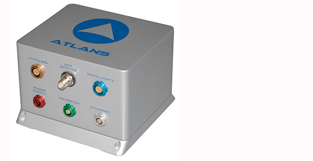
iXBlue, a provider of navigation, positioning, and mapping solutions, has launched its new ATLANS-C position and orientation system, developed in close cooperation with Septentrio Satellite Navigation. The system is designed to provide continuous and accurate positioning in urban environments, where GNSS signals are obscured, intermittent, or possibly distorted by reflective surfaces.
ATLANS-C benefits from the optimized integration of iXBlue’s fiber-optic gyroscope (FOG) based inertial navigation system (INS) and Septentrio’s multi-constellation GNSS receiver technologies. Experts from iXBlue and Septentrio worked closely to develop a “smart” coupling method that combines the advantages of the two companies’ technologies. The result is an easy-to-use, easy-to-integrate, and highly reliable INS-GNSS mobile mapping solution, the companies said.
“The ATLANS-C development was a real team effort,” said Jan Van Hees, head of sales and business development at Septentrio. “Technical trials with leading customers have already demonstrated superior accuracy, continuity, and reliability of positioning and attitude data, even in the most challenging urban environment.”
“The new system’s robustness, compact size, and improved urban-area performance uniquely address more complex mobile mapping market requirements. The ease of use, quick integration, and zero maintenance features are excellent values recognized by original equipment manufacturers (OEM) or mobile mapping system integrators,” explained Xavier Montazel, head of iXBlue inertial products division. “One of ATLANS-C’s many other advantages is its versatility, allowing the same equipment to be used for land and air applications. Configuration of the system is achieved through the use of iXBlue’s innovative web interface, utilized across the complete range of products.”
ATLANS-C has no ITAR components inside, allowing fast and easy global export. Customers will benefit from the industry exclusive five-year warranty and a 24/7 support line. ATLANS-C is available today with a six-week lead time.
Trimble is adding to its airborne LiDAR portfolio with the Trimble AX60i and AX80. Both are highly capable, versatile systems that meet the demands of aerial survey operators for corridor and wide area mapping projects, Trimble said.
The new airborne systems, together with flight planning and analysis software tools, have been designed to provide rapid and efficient point cloud capture as well as high-resolution images and proven workflows with high productivity. The systems can be installed on either fixed wing or rotary aircraft.
Designed for low-altitude corridor mapping applications, the Trimble AX60i is an entry-level LiDAR system built on the same versatile platform as the high-altitude AX60 system, Trimble said. The platform allows AX60i users to upgrade to an AX60 in the future. The AX60i can be operated up to 5,000 feet above ground level (AGL) while offering a 400-kHz laser pulse repetition rate (PRR) with a single-channel, downward-looking laser.
The Trimble AX80 is a dual-channel LiDAR system that can be operated up to 15,500 feet AGL and is designed for the most demanding survey applications from high-altitude wide area mapping to detailed low-altitude corridor mapping. The AX80 offers an 800-kHz PRR with revolutionary forward- and backward-looking capability to enhance point density on the ground and improve image resolution. This two-dimensional oblique view offers unparalleled scanning of vertical facades of structures.
Trimble’s AX80 aerial imaging system.
An optional, fully-calibrated 80-Megapixel camera with forward motion compensation can be added to the AX60i and AX80 systems. The camera is integrated into the sensor head package and harmonized with the laser sub-system so that it does not need re-calibration each time the system is fitted to an aircraft.
These systems are optimized for precision applications, providing a uniform distribution of laser points across the entire field-of-view to widen the usable swath width. Operators can reduce track overlap or duplication, or fly at higher altitudes to achieve a given resolution. Together with a high-precision positioning system, integral power supplies and an in-flight monitoring tool, the Trimble AX60i and AX80 can allow operators to lower the complexity of airborne LIDAR surveys while increasing the quality of the output.
“The Trimble AX60i and AX80 systems extend our portfolio of aerial imaging solutions to meet a variety of mapping applications,” said Phil Sawarynski, business area director of Imaging Solutions for Trimble’s Geospatial Division. “They have been designed as true end-to-end solutions and are delivered with Trimble flight planning software and Trimble Inpho analysis software. Because everything is supplied by Trimble, operators can have confidence that the complete solution works together properly, and that the flight planning and post-mission analysis suites will enable them to provide a high-quality service to their customers.”
Wind generates electricity by turning the blades of turbines. Individual turbines can range in height from several dozen to several hundred meters tall, with blade lengths measuring several dozen meters. Image credit: USGS
Wind energy is one of the fastest-growing sectors of renewable energy in the United States. About 3% of the total electricity in the United States was generated by wind turbines in 2012 (according to the U.S. Energy Information Administration), which is equivalent to the annual electricity use for about 12 million households. The amount of electricity generated by wind has increased from about 6 billion kilowatt hours (kwh) in 2000 to 140 billion kwh in 2012.
In response to the Department of Interior’s Powering Our Future initiative, the U.S. Geological Survey (USGS) has begun investigating how to assess the impacts of wind energy development on wildlife at a national scale.
Assessment Experience
The USGS has extensive experience assessing energy resources, and it’s that expertise that makes the USGS qualified to assess nationwide impacts of wind energy development. One of the major reasons behind the success of USGS energy resource assessments is the scientifically robust methodology that underpins them.
USGS energy resource assessment methodologies are publicly available and are technically peer reviewed externally, and just as importantly, are used consistently in every assessment. That means that a USGS oil and gas assessment in Alaska provides comparable information to a USGS oil and gas assessment in Texas, or that a USGS geothermal assessment in California is comparable to a USGS geothermal assessment in Nevada.
A Different Kind of Assessment
USGS has recently undertaken a project to develop a methodology for assessing wind energy impacts on wildlife at a national scale. This research is different from previous USGS energy assessments. Instead of looking at technically recoverable resources of oil, gas, geothermal or coal, or even technically accessible storage areas for carbon sequestration, the USGS is developing a method for determining the impacts of a type of energy production. This work will merge the experience the USGS has creating assessment methodologies with its expertise in wildlife ecology and wind-wildlife research, as well as in land change science.
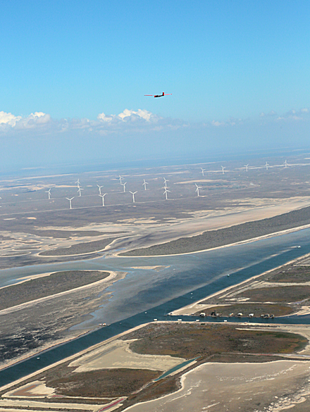
Wind turbines are often grouped together in facilities to maximize electricity-generating capacity. This image shows a wind farm on BLM land in California. Image credit: BLM
Wind energy can impact both wildlife and their habitats. Wildlife impacts include potential bird and bat mortality from collisions with turbine blades, and in some cases, species avoidance of habitat near turbines. Habitat impacts include the turbine pads in addition to service roads, transmission lines, substations, meteorological towers, and other structures associated with wind energy siting, generation, and transmission.
Turbine Locations
The first step in understanding the impact of wind energy development is to determine where the wind turbines are located. Prior to this study, there was no publicly available national-level data set of wind turbines. There were maps that showed turbines locations in a few states, and there were national-level maps that showed wind power facilities, but not individual turbines, or information about those turbines, such as height, blade length, or energy producing capacity.
A screenshot of the USGS WindFarm Mapping Application, which allows users to access the more than 47,000 individual wind turbines contained within the national wind turbine database. This view shows facilities in Southern California, color-coded for their wind-generating capacity. The red and yellow turbines have a higher electricity-generating capacity than the green and blue turbines do.
To remedy the lack of information, the USGS created this publicly available national dataset and interactive mapping application of wind turbines. This dataset is built with publicly available data, as well as searching for and identifying individual wind turbines using satellite imagery. The locations of all wind turbines, including the publicly available datasets, were visually verified with high-resolution remote imagery to within plus or minus 10 meters.
Knowing the location of individual turbines, as well as information such as the make, model, height, area of the turbine blades, and capacity creates new opportunities for research, and important information for land and resource management. For example, turbine-level data will improve scientists’ ability to study wildlife collisions, the wakes causes by wind turbines, the interaction between wind turbines and ground based radar, and how wind energy facilities overlap with migratory flyways.
Next Steps
In addition to the value this powerful tool has to Federal and State land managers, non-governmental organizations, the energy industry, scientists, and the public, it will be a useful component in the methodology that the USGS is developing for assessing wind energy impacts. The USGS is bringing together scientists with expertise in landscape-level science, wildlife biology, and other associated disciplines to create the methodology. Once developed, the methodology will be externally peer-reviewed and tested with pilot-level data projects. Once peer reviewed, the revised methodology will be published for others to understand and use.
Telenav, Inc., announced today that it has acquired skobbler GmbH, the European-based navigation company with the highest rated OpenStreetMap (OSM)-based GPS navigation apps in the world. With this acquisition, Telenav brings the most successful OSM navigation experts in the world together as one team — including the founder of OSM, Steve Coast, who joined Telenav in 2013 — and becomes a major contributor to the creation of the open-sourced and most comprehensive map of the world, according to the announcement.
The acquisition closed on January 29 for consideration of approximately $19.2 million in cash and $4.6 million of company common stock.
“Crowdsourced OSM can power personalized navigation services like Scout — with highly detailed maps on a global scale,” said HP Jin, Telenav’s chairman and CEO. “We plan to offer Scout with OSM for much of the world. We have already made significant headway toward this goal in the U.S., including using OSM for our HTML5 version of Scout.”
OSM is the only crowdsourced and open-sourced map of the globe and, for many developers, it has become a clear alternative to Google Maps.
“Waze and Google — or, just Google now — provide similar mechanisms to improve their maps, based mostly on OSM’s innovations. With one big catch. It is very much their map. Not yours,” said Coast in his blog commentary today regarding the acquisition. “OpenStreetMap is different. All of the quality data contributed is openly available — just like Wikipedia. So, anyone can download, experiment and play with it freely. It’s not locked up beyond your reach.”
Since Coast founded OSM, the community has doubled year over year to more than 1.5 million registered editors, becoming a global community of local editors in every corner of the world. Its crowdsourced model publishes edits every minute on openstreetmap.org, resulting in maps that are detailed and up to date. For example, newly laid streets and newly developed areas can be updated on a regular basis and in real time. In addition, OSM allows for greater map detail for pedestrians such as alleys, sidewalks, parks, hiking trails, zoos, and even city trees.
Telenav has been an active contributor to OSM for more than three years, working closely with the community to enhance specific features needed for navigation, traffic and other future location-based services.
With offices in Germany and Romania, skobbler was the first company to launch a commercial navigation app using OSM (in 2010) for both Android and iOS devices and is available in app stores in 49 regions with worldwide map coverage. In order to do this, skobbler developed sophisticated algorithms that evolved OSM data from a display map to a navigable map.
skobbler’s apps are top ranked and highly rated in multiple countries including Germany, the Netherlands, and Sweden. skobbler’s CEO, Peter Scheufen, previously served as the CEO of Navigon, which became a leading GPS device manufacturer in Europe and was eventually purchased by Garmin. The other skobbler founders also held senior roles at Navigon before founding skobbler. Telenav expects that all skobbler employees will join Telenav as part of its OSM team, bringing significant industry-leading software expertise in location-based services, navigation and mapping.
“By joining our efforts with skobbler, we will build on our combined successes to bring the best mapping and navigation services to our customers around the world,” said Jin. “The benefits of an open source model will provide an enormous opportunity to change the economic models of navigation and other location-based services.”
“OSM is currently one of the most active and dynamic crowdsourcing communities and is growing at an explosive rate,” said Scheufen. “Our team lives and breathes OSM and so we are excited to join forces with Telenav to create the largest, most sophisticated, and smartest OSM navigation team in the world.”
In connection with the acquisition and in accordance with NASDAQ Marketplace Rule 5635(c), Telenav granted four employees of skobbler and its subsidiaries, upon the closing of the acquisition, restricted stock units for an aggregate of 634,920 shares of common stock.
These RSUs were granted outside of the existing Telenav stock plans and without stockholder approval pursuant to NASDAQ Marketplace Rule 5635(c)(4) with the following terms: each RSU vests as to 50% of the award on the anniversary of Acquisition and as to 50% of the award on the second anniversary of the Acquisition, subject to continued employment through each relevant date.
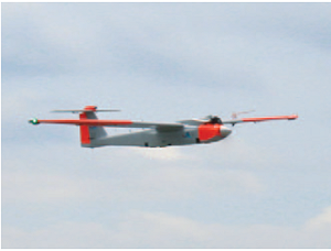
Applanix Corporation and American Aerospace Advisors have completed a successful series of test flights of AAAI’s RS-16 platform equipped with Applanix’ DMS-UAV aerial photogrammetry payload. This is the first successful mission for a long-endurance UAS (unmanned aerial system) capable of producing professional-grade, directly georeferenced mapping imagery for civilian applications such as pipeline monitoring, power line and emergency response mapping.
The RS-16 Unmanned Aircraft System equipped with the Applanix Direct Mapping Solution (DMS).
Tests were conducted over restricted airspace in the state of New Jersey. A joint team from Applanix and AAAI planned and flew a sequence of missions to evaluate the capabilities of the UAS. These include, critically, the ability to provide highly accurate, directly georeferenced and orthorectified aerial imagery without the need for ground control points or aerial triangulation calculations. The system, consisting of the airframe, its avionics, mobile ground control station and the digital mapping payload, performed according to expectations and successfully produced high-quality imagery.
“Performing safe and successful missions with long endurance unmanned aircraft in civilian airspace are a challenge that goes far beyond selecting the right aircraft and payload,” said David Yoel, CEO of American Aerospace Advisors. “Working with Applanix, we have produced an integrated system that is designed from the ground up with civilian mapping operations in mind. We believe this system has the capability to transform the aerial mapping industry.”
The Applanix RS-16 in flight.
The RS-16 DMS is a complete, operational system capable of conducting large area operations within the National Airspace System in the United States, and in other jurisdictions as local regulations allow. Within the USA, AAAI is engaged with several of the recently announced UAS research and test sites, which operate under the auspices of the FAA to develop the certification and operational requirements necessary to safely integrate UAS into the national airspace.
The GNSS-Inertial systems at the core of Applanix’ DMS-UAV aerial mapping payload uses commercial inertial technologies that are offered globally.
“The market for airborne imaging systems is in a state of rapid change,” said Joe Hutton, director of Inertial Technology and Airborne Products at Applanix. “Developments in imaging technology, in processing capability, and in the nature of inertial sensors, make a directly georeferenced UAS a reality today, where it would have been inconceivable even a few years ago. Our ability to take our established market-leading manned solutions, and integrate the technology successfully into an unmanned platform, speaks volumes for the engineering expertise of Applanix and AAAI.”
Arcturus T-20 unmanned aerial vehicle with 3D imaging pods on a recent test flight at a Southern California test range. (PRNewsFoto/Arcturus UAV)
The GeoDragon sensor system by Urban Robotics has been integrated and flown on an Arcturus UAV T-20 Tier II unmanned aerial vehicle. The sensor system is enclosed in a wing-mounted pod and is capable of high-resolution 2D and 3D image capture.
GeoDragon adds significant 3D imaging and mapping capabilities to the T-20 UAV. The GeoDragon system can create 3D reconstructions in near-real time and output high-resolution digital elevation models, LIDAR-like datasets, and wide area maps. The system will be released in mid-2014.
The sensor was designed by Urban Robotics in Portland, Oregon. The aircraft was built by Arcturus UAV in Rohnert Park, California.
According to Arcturus, the unique aspects of the system are low weight (equating to longer endurance and loiter time,) small operational footprint on the ground (1 or 2 full size pick-up trucks,) a quick mount/dismount pod, quiet operation (the T-20 utilizes a modified four-stroke engine), and the ability to fly simultaneously with other payloads on the T-20, such as EO/IR.
GeoDragon imagery is post-processed using automated 3D algorithms to rapidly generate large mapping and modeling datasets. Urban Robotics develops software and hardware solutions for 3D ISR, remote sensing and geospatial applications, including collection, post-processing, and data management.
The T-20 is a runway independent, Tier II class, small tactical unmanned aerial vehicle with a technical readiness level (TRL) 9. The primary mission of the Arcturus UAV is intelligence, surveillance and reconnaissance. Typical missions include aerial mapping, drug interdiction, fire-fighting, border patrol, force protection, search and rescue, as well as military ISR. Payloads include full motion video from daylight and infrared cameras. Video is then transmitted by secure data link to mission commanders on the ground. An onboard GPS autopilot with waypoint navigation accepts multiple flight plans from the Ground Control Station, allowing the T-20 to return to a specified location autonomously after up to 16 hours of flight.
The T-20 is powered by a 190cc an air-cooled, four-stroke, fuel injected engine. Carbon fiber composite construction used in the T-20 airframe allows for payloads up to 65 lbs.
Trimble has added its Trimble UX5 unmanned aircraft system (UAS) to its agriculture product portfolio for aerial imaging and mapping. The Trimble UX5 system can enable ag service providers to capture aerial images for scouting and monitoring crop health such as detecting pests, weeds and nitrogen deficiencies.
The system also can locate cattle and their available forage over large areas, measure crop height, and generate topographic maps and models for land leveling and drainage applications.
As a result, the system provides farmers’ advisors — agronomists, Trimble resellers, and other ag service providers — with a powerful data collection tool that can aid with recommendations to improve farming operations.
The UX5 system flies at 80 kilometers/hour (50 mph) and is stable in significant crosswinds and light rain. In a single 50-minute flight, the system can cover a two square kilometer (0.8 square mile) area at five centimeter (two-inch) image resolution. It comes with a camera modified to capture the near-infrared spectrum, which helps in deducing vegetation indexes for crop health assessment. The UX5 system can capture a variety of images to be processed post flight. The output of a single flight provides geo-referenced precision images, a digital surface model (DSM) showing elevations as a color image, and a dense 3D point cloud that includes elevations.
“The addition of the Trimble UX5 system strengthens our agriculture product portfolio and enables us to provide a solution that benefits a broad range of customers including growers, ranchers, water management contractors, agronomists and other ag service providers,” said Joe Denniston, vice president of Trimble’s Agriculture Division. “High-speed aerial imaging is a powerful tool that can quickly and easily locate problem areas to be addressed. The faster a problem area is discovered, the better the chance it can be evaluated and resolved before crop yield is impacted.”
Trimble provides training for system operators and their observers, which focuses on safety precautions and the application of the Trimble UX5 system for maximum success. The Trimble UX5 system is available from authorized agriculture distribution partners and is subject to regulations and restrictions defined by local civil aviation authorities. Unmanned aircraft systems are not allowed to be flown in some regions or for certain applications.
In association with Times Higher Education, Esri published an interactive map of world university rankings for the school year 2013-2014. Click on the image below to view the map.
senseFly’s drones eBee and swinglet CAM, both designed for mapping missions, are now also capable of quickly taking oblique images to complement a mapping project or add additional documentation.
This patent-pending technology is based on a proprietary control algorithm that takes oblique images of photo targets without the need of a camera gimbal, enabling senseFly’s ultralight mapping drones to take aerial shots with an up to 45-degree inclination from the photo target.
The algorithms running on board the drone’s autopilot automatically place and orient the drone based on the defined image resolution and inclination (0-45°) selected by the operator. The drone then adapts its trajectory according to local wind and target altitude.
Having a system that positions the camera autonomously with respect to the photo target enables senseFly’s drone systems to take precise oblique images without the need for live video feedback or a camera gimbal.
As these new techniques do not require any hardware changes, this ability is freely available to the community of eBee and swinglet CAM (late 2012 model) users with the new release of eMotion 2.2.
Beside creating stunning visuals, senseFly’s latest release of Postflight Terra 3D will enable users to go one step further and add these oblique images to a standard mapping flight, adding visibility to facades and vertical surfaces.
How will 3D printing and the geospatial community affect each other?
Many of us in the Intelligence, Surveillance, and Reconnaissance (ISR) business chuckled at the publicity stunt Amazon pulled by demonstrating UAV doorstep delivery of packages. This was smart marketing by Amazon, and although the technology may not be farfetched, the institutional issues are and will create a long, steep hill for Amazon to climb. There is, however, a growing revolution that Amazon is not talking about that could give them some serious challenges in the not-too-distant future — 3D printing. Last August I wrote about significant improvements in 3D printing demonstrated at the Consumer Electronics Show (CES), including creation of metal parts. This technology will most likely affect the geospatial community in ways we haven’t considered, but we geospatial experts will also have an impact on the 3D printing community.
How far has 3D printing come?
The first 3D printer I saw in action was a terrain printer at the Esri User Conference about five years ago. The concept was very simple. The printer laid down a thin 12-x-12-inch layer of special powder, followed by inkjet print heads that laid down ink that both colored and fused the powder. The process took hours as layer on layer of powder and ink built the terrain model. When complete, the uninked powder was brushed away, revealing the solid 3D model. The model could have complex undercut shapes such as a highway overpass, but the material was also somewhat brittle like unfired clay. Users could create more durable objects by using the models as forms to make castings out of aluminum or epoxies.
Developers of the budding technology have not stood still. New printers use plastic filaments to build up 3D objects, and some even use exotic technology to build objects made of fused metal such as this example. Repair parts can be created by using a 3D laser scanner to create 3D CAD models that can then be modified to add reinforcement where needed to make the replacement part better than the original. Bio-medical printers are being used to create human body parts such as ear cartilage, artery sections and dental appliances like this replacement jaw. There are even some experiments planned next year as Performative Architecture to print buildings with plumbing and other components included. On a micro level, scientists are printing complex nano devices and chemical compounds to create objects that can’t be produced in any other way.
An 83-year-old woman has become the first person to have a 3D printer-created jaw fitted. (from The Telegraph).A 285 µm racecar, printed at the Vienna University of Technology (from Phys.org).
A common phase used by 3D printing practitioners is that “complexity is free” in that it takes no more effort to print something complex than it does something simple. In fact, 3D printing becomes more economical as complexity increases, because labor costs decrease and a greater number of voids reduces the amount of raw material needed to build objects. So, look for objects such as bikes or cycles that look very organic, perhaps made of titanium, with very strong and economic internal cellular construction that may mimic the bones of birds.
How fast are things moving?
Microsoft has just added a “direct pipeline” to 3D printers from 3D printing applications such as Autodesk. If you still aren’t convinced that 3D printing is going mainstream, consider this. Staples office supply is now offering 3D printing at some of its printing/shipping centers. Add to these developments the concepts of self-assembly and of use of nano devices and we are entering a very disruptive period and environment. I believe that geospatial aspects of our world will be significantly affected by this technology, but we will also play a significant part in the development and implementation of 3D printing. So let’s speculate on the possible impact on both communities.
Our impact on the 3D printing community
Those trained in geospatial tools and techniques are well positioned to develop and operate 3D manufacturing systems. Most of us have excellent computer skills as well as the ability to visualize complex 3D objects, while also working with abstract concepts. We also understand 3D modeling software, linked databases and web development tools. Many of us have sophisticated software development knowledge and the ability to manage complex systems and processes. If architectural printing actually becomes a reality, GIS/CAD/BIM will be an integral part of the total process. So whether you remain on a geospatial career path or evolve into these new technologies, your knowledge and skills will serve you well.
3D printing’s impact on the geospatial community
“The cheapest 3D printers, which print rudimentary objects, currently sell for between $500 and $1,000. Soon, we will have printers for this price that can print toys and household goods. By the end of this decade, we will see 3D printers doing the small-scale production of previously labor-intensive crafts and goods. It is entirely conceivable that in the next decade we start 3D printing buildings and electronics.” Slashdot
Transportation
My first speculation is transportation and city growth. You may remember from your geography classes that center cites and edge cities grew out of the need to centralize manufacturing, sales, specialized activity, meetings, etc. If 3D printing becomes ubiquitous, there will be less need for large manufacturing plants, little need for warehouses, and significantly less shipping activity. The primary need for shipping will be for bulk materials used in 3D printing. Since raw materials can be more efficiently shipped than finished bulky goods, there will be greater use of tankers and pipelines.
When I was at the Atlanta Regional Commission, a large portion of our efforts were geared toward regional transportation planning. Using GIS data layers that defined where people work and where they live were key components of these “Origin – Destination” models used to predict traffic patterns. Large manufacturing facilities were always key employment centers. If small local 3D print shops or even home 3D printers could manufacture almost any item, large centralized plants becomes obsolete and the transportation needs change significantly.
Retail
Commercial shipping could be relegated primarily to raw materials. What happens to WalMart or Amazon if everyone has a home 3D printer and all you need is to download a digital file and have some raw materials on hand?
Real estate
In my early GIS career, I spent considerable time doing ring studies, trade area analysis and targeted marketing. The reduced need for retail stores and corresponding warehouses could turn that process on its head. Couple this kind of manufacturing with other technology, such as video conferencing and robotic medicine, and location favoring city centers is reduced. This would certainly impact real estate values as location factors evolve away from crowded centers.
Energy, environment and resources
A very positive impact could be on the environment. Reduced transportation requirements will cut traffic and corresponding pollution. The more efficient use of raw materials and better direct recycling of many plastics is another positive factor. I’m not sure how the energy equation would work with mass production vs. individual replication and reduced transportation but my gut feeling is that it would be a net positive result.
Military and emergency responders
The U.S. Navy is already experimenting with 3D printers to reduce the number of repair parts that are stored on ships or in the supply chain. I personally experienced the early benefits of shipboard digital technology by reducing huge libraries of paper repair manuals. An average three-foot stack of international paper navigation charts on each ship recently went digital. First responders could replicate emergency equipment repair parts on demand at NIMS Area Command Centers providing logistics support for major incidents.
Geopolitics
Internationally, many large overseas manufacturing facilities could become obsolete. U.S. companies are bringing some operations back home. The geopolitical consequences could be significant. This even applies to the manufacture of clothing. Imagine having clothing that fits perfectly, printed on demand at a neighborhood 3D print store. A positive effect could be that less developed countries may have access to goods that currently are not affordable.
Unknown unknowns
Although 3D printing has made great strides in five years, it’s still far from being competitive with traditional mass production. Speed, object size and mixed materials/media are still an issue. There are many naysayers on 3D printing sites. Many believe that the technology is too slow and limited along with a myriad of other problems. I have no doubt that many if not all these issues will be resolved or augmented with other technologies. We are also viewing the technology in terms of our current knowledge and perspective. My first experience with digital mapping was a 286 PC driving a xy pen plotter that mimicked the job done by draftsmen. At the time, no one imagined that HP could spray micro drops of ink on paper to rapidly produce billboard-sized plots with color imagery as we do today.
I believe we are in for a wild ride as the technology evolves. The above speculations are just my preliminary thoughts. I’ll bet that many of you have additional observations and speculations. I’d like to hear from you in the comments section. To learn more, you may want to attend a key 3D Printing conference in New Your April 2-4.