Trimble is offering office software, site positioning and machine control solutions designed for site and utility contractors and owner/operators. These solutions offer small to mid-sized contractors a reliable, flexible and affordable option to leverage construction technology.
Many contractors already use SketchUp Pro for layout and visualization. SketchUp’s affordable price point and ease of use make it an ideal solution for small site and utility contractors who do not have a software specialist on staff.
Now, SketchUp files can be exported to Trimble SCS900 Site Controller Software using the new Trimble Site Contractor extension for use in site positioning applications.
Site Positioning
Trimble Site Positioning Systems have also made significant improvements for smaller contractors. Trimble SCS900 Site Controller Software has introduced two new capabilities, EZ Level and BaseAnywhere.
EZ Level replaces traditional laser transmitters with GNSS or total stations for easy elevation checking when no design is available. BaseAnywhere allows contractors to quickly set up their Trimble SPS585 GNSS Smart Antenna as a base station anywhere on the site, with no survey control necessary, making it much simpler and faster for a non-surveyor to use GNSS.
In addition, corrections can now be streamed to the SPS585 using BaseAnywhere and Wi-Fi. No radio is needed, so smaller contractors have a very affordable way to receive GNSS corrections on site.
Machine Control
The Trimble GCS900 Grade Control System can now be installed on many skid steer loader grading attachments from a variety of manufacturers. The installation includes integration to the machine’s joystick controls, so contractors can take full advantage of the technology on their machine to increase productivity and accuracy.
“Trimble has made it easier than ever for smaller contractors to take advantage of construction technology,” said Scott Crozier, director of marketing for Trimble’s Civil Engineering and Construction Division. “With office software, site positioning and machine control solutions designed to make the technology easier to use and more affordable, site and utility contractors are able to enjoy increased productivity gains and efficiency that larger companies benefit from today.”
Asteri Navigation will introduce a new line of rugged, compact and fully integrated GNSS receivers on Nov. 15 at the 2016 Autodesk University in Las Vegas, Nevada.
Suitable for geospatial field data collection and inspection applications that require high accuracy positioning, the Asteri X-Series receivers are light enough to be mounted to external sensors or worn on the body or arm.
Asteri Navigation will debut the affordable X-1 and X-2 receivers in booth No. 1783 at Autodesk University, which runs from Nov. 15-17 at The Venetian in Las Vegas. The X-3 is scheduled for release in December.
The compact Asteri receivers were designed with safety and ease of use in mind. Each device weighs just 11.3 ounces with the 12-hour lithium battery. Their 2.8-inch by 5.4-inch size allows them to fit safely in shoulder or arm pouches.
The internal single-frequency antenna enables users to capture accuracies of well under 10 centimeters with RTK/VRS corrections. This integrated design allows users to work in difficult terrain without worrying about equipment and antennas getting snagged or broken.
Engineered to provide centimeter-level accuracy with Real-Time Kinematic (RTK) or Virtual Reference Station (CRS) correction when connected to an external antenna, the Asteri GNSS receivers support a generic NMEA 0183 GNSS data protocol. This makes them compatible with data collection and field mapping applications supporting the same protocol and ideal for users who want to develop their own software applications for inspection and GIS data capture activities.
The new receivers can communicate via Bluetooth or cable with most popular devices used for field data collection, including utility line locators, ground penetrating radar, data loggers, laser rangefinders, smartphones, and tablets.
Asteri expects the X-Series will be used extensively in mapping and survey applications related to asset management, pipeline operation, utility construction, forestry, electric staking, and underground utility location.
For users needing higher accuracy, an external multi-frequency antenna can be added to the provided port on the receiver. In addition, the Asteri X-3 will be compatible with Atlas GNSS satellite-based real-time correction services worldwide.
The three products in the X-Series provide varying levels of accuracy:
X-1 provides sub-meter accuracy out of the box.
X-2 offers accuracy of 1 meter down to 1 centimeter with RTK/VRS.
X-3 will achieve 1 centimeter with RTK/VRS, 30 centimeters with Atlas H30, 4-10 centimeters with Atlas H10.
The United States Federal Aviation Administration (FAA) has released its Performance-Based Navigation (PBN) National Airspace System (NAS) Navigation Strategy 2016, the result of a concerted year-long effort by FAA and aviation industry stakeholders. It describes how the FAA intends to transition U.S. NAS operations over the near- (2016–2020), mid- (2021–2025) and far-term (2025–2030) from predominantly point-to-point navigation, reliant on hundreds of ground-based navigation aids, to PBN-centric operations relying on systems and services supporting Area Navigation (RNAV) and Required Navigation Performance (RNP).
Performance-based navigation specifies the aircraft area navigation performance in terms of accuracy, integrity, availability, continuity and functionality needed to conduct specific operations in a particular airspace.
While promoting the PBN benefits of GNSS such as the GPS and the Wide Area Augmentation System (WAAS), the PBN Strategy also recognizes the need to maintain resilient PBN capabilities that remain unaffected in the event of GNSS interference, and that can continue to support PBN operations or provide safe navigation alternatives. It is a well-constructed, valuable document that provides detail on the means by which many of the Operational Improvements (OIs) described in the FAA’s Next Generation Air Transportation System (NextGen) implementation Plan (NGIP) will be achieved.
The FAA began the introduction of PBN operations following the release of its Roadmap for Performance-Based Navigation in 2003, which promoted more efficient and higher capacity operations based on the capabilities of modern aircraft and emerging GNSS-supported PBN procedures. By 2010, many PBN procedures were in use across the NAS, and especially at the busiest airports and most complicated and congested airspace. Building on this experience, the 2016 PBN Strategy recognizes that the U.S. NAS is not a homogeneous entity; its needs vary based on both location and time. To best serve NAS users and to continue to provide the safest, highest capacity, most efficient airspace in the world, some of the key concepts of the strategy are to provide:
the right procedure to meet the need;
structure where beneficial and flexibility where possible;
shifting to time- and speed-based air traffic management;
and delivering and using resilient navigation services.
To provide correct procedure and structure where needed, the PBN Strategy defines six Navigation Service Groups (NSG) and services potentially available at the airports within each group. NSG 1, now comprising about 15 airports, is reserved for the busiest large hubs that would benefit from common aircraft performance capabilities to maximize capacity. NSG 2 contains the remaining large-hub and all medium-hub airports. Small and non-hub airports comprise NSG 3. NSG 4 includes more than 500 airports, including national and regional general aviation (GA, or private plane) airports, and NSG 5 2,400 local and basic GA airports. NSG 6 consists of thousands of small airports not part of the National Plan of Integrated Airport System (NPIAS).
Time- and speed-based navigation is essential to optimal utilization of airport capability and capacity for both arrival and approach and departure operations. The ability of aircraft to more precisely follow PBN procedures because of onboard navigation capability and space- and ground-based navigation services maintains safety, increases airspace and runway utilization, and — because of more efficient, precise routing — minimizes fuel burn and carbon footprint.
The PBN Strategy also recognizes the need to maintain resilient PBN services and, while GNSS-provided PNT services are able to support both RNAV and RNP procedures, GNSS is vulnerable to both intentional and unintentional interference. To preclude loss of efficiency and capacity benefits in the event of GNSS interference, the FAA will maintain and improve the ground-based Distance Measuring Equipment (DME)/Tactical Navigation (TACAN) network to support DME-DME RNAV 2 in the enroute domain and RNAV 1 in the necessary terminal domains. Because of plans to fill gaps in coverage at high altitudes (FL 180 and above) and remove single DME facility criticality, aircraft without inertial reference units (IRUs) will be able to fly these procedures using DME-DME RNAV, although at the much lower altitudes associated with terminal operations, an IRU may still be required. For aircraft without DME-DME RNAV capability, for example General Aviation, the FAA will maintain a Minimum Operational Network (MON) of Very High Frequency Omnidirectional Ranges (VORs) to either support navigation out of a GNSS interference area or navigation to an airport where approach and landing is supported by either an Instrument Landing System (ILS) or VOR.
Commentary
PBN services depicted across Navigation Service Group airports represent the standard in the far term, 2026–2030.
The FAA’s plan to maintain resilience, while admirable, does have some issues. All of the VORs, DMEs and TACANs that provide resilient navigation services are extremely old, the vast majority designed in the 1970s and installed in the 1980s. There is no current plan to modernize or recapitalize them.
As for researching and developing an Alternate Position, Navigation and Timing capability that would support resilient PBN capability for all of aviation, maintain the ability for aircraft to report their positions via Automatic Dependent Surveillance – Broadcast (ADS-B), and support the rapid and vast emergence of unmanned aerial vehicles (UAS) and benefits, the PBN Strategy states that “During the far term and moving out into the 2030 timeframe and beyond, the FAA will continue to research the best methods for Alternate Position, Navigation and Timing (APNT).”
This delay is unfortunate, as further delay in implementing PNT resilience for all aspects of aviation, as well as for all critical infrastructure areas is, at best, imprudent, as recent agency attempts to develop and implement other resilient PNT capabilities — Enhanced DME (eDME) and Enhance Loran (eLoran) — have been suspended.
The release of the 2016 PBN Strategy is a significant event. It will help guide the agency and the aviation community forward. It will help clarify policy, facilitate decisions, drive equipage, and provide for a safe, higher capacity and more efficient NAS. It is a good start, which could be improved by recognizing the significant investments needed in resilient PNT equipment, architecture and systems.
The GSC2000 now works with Engon tiltrotator excavator attachments.
Trimble and Engcon announced at Trimble Dimensions that the Trimble GCS900 Grade Control System can now be used with Engcon tiltrotator excavator attachments. Trimble machine control gives excavator operators using an Engcon tiltrotator precision guidance, which can result in time and fuel savings for contractors.
“Working closely with Trimble, we have made high-precision guidance available for Engcon tiltrotator attachments,” said Fredrik Jonsson, development manager at Engcon. “Major gains in productivity and precision can be realized by customers when the Engcon tiltrotator is used with the Trimble GCS900 Grade Control System.”
“We are excited about linking Trimble machine control to Engcon’s tiltrotator system,” said Scott Crozier, marketing director for Trimble’s Civil Engineering and Construction Division. “When operators receive accurate guidance in the cab about the tilt and rotation position of the bucket, excavations to designs can be performed faster and more productively.”
When Engcon tiltrotators are used with the Trimble GCS900 Grade Control System the bucket position and orientation are always visible regardless of bucket rotation. The operator can see the height and the rotation, so the attachment can be more efficient when used for mass excavation, fine grading and working in confined areas.
Soldier-borne sensors, leader-follower cargo-hauling technology and tiny, handheld unmanned aircraft are in the forefront of new technologies planned for U.S. warfighters, according to Maj. Gen. Robert M. “Bo” Dyess. The deputy director of the U.S. Army Capability Integration Center told AUVSI’s Unmanned Systems Defense keynote audience that developing tools and systems demanded by soldiers is key. He cited a recent demonstration exercise, in which soldiers responded enthusiastically to small, backpackable UAS that would let them see over the next hill or fence.
The Army is also developing autonomous ground systems including an unmanned combat vehicle, fully autonomous convoy operations and swarming unmanned aircraft. Autonomous weapons are seen as key in combatting both relatively low-tech guerilla and militia groups as well as high-tech “near-peer” combatants from organized industrial powers. A contested electromagnetic spectrum is emerging as a critical battlefield in the contemporary and future warscape, Dyess said. Cyberspace, racked by fundamental threats of spoofing, jamming and hacking, becomes the new killing ground.
Shad Reese, Tactical Warfare Systems, Unmanned Vehicles coordinator for the Office of the Undersecretary of Defense, said DoD is elaborating a new unmanned systems roadmap, which should be published in the first quarter of 2017. The roadmap will cover the period 2016-2041.
Reese said that a key aspect of the new roadmap is swarming technology, although at present there is little work underway in industry to support this. “Everyone and their mom is talking about swarming, but if you step back and look at what’s going on in industry, there are no real players in industry working on swarming.” Some work is underway in academia, but “we would like to have commercially available swarming technology.”
The Army’s squad mission support transport robot (SMET).
Army’s Ground Robots
The Army has put a robotic vehicle, the squad mission support transport robot (SMET), designed to carry heavy loads for troops, into an accelerated acquisition program. SMET is a 1,000-lb. tracked or wheeled platform carrying rucksacks, water or ammunition. A SMET version was recently tested in Afghanistan.
An Army spokesperson said the SMET has also been chosen as a pilot program a new way to do acquisitions that could shave time off development and fielding of new technologies, with industry involved from the start in specifications and requirements.
Swarms
Hordes of flying, thinking armed robots that autonomously coordinate amongst themselves, altering attack strategies in mid-mission and pushing through to strike targets kamikaze-style, are also seen as critical to future combat. The Air Force Research Laboratory calls the tactical weapons “distributed collaborative systems.”
Three drones work together to beam back information about an enemy’s location, and blocks their radar signals. (Image: DARPA)
The Air Force seeks to put “that next level of decision making and capability on the platform. Not only can it maintain itself, but it can work other parts of the team, whether those be airmen, or whether those be other machines to perform a mission task.”
Swarming micro-drones can be “really fast, really resistant. They can fly through heavy winds and be kicked out the back of a fighter jet moving at Mach 0.9, like they did during an operational exercise in Alaska last year, or they can be thrown into the air by a soldier in the middle of the Iraqi desert.”
“Swarming is a way to gain the effect of greater intelligence without each individual unit needing to be intelligent,” added one strategist. Last year Gen. Ellen Pawlikowski, commander of the Air Force Material Command, called swarming drones “very much a game-changing reality for our Air Force in the future.”
One consultant added that a human operator may not be able to compete with a fully autonomous system that identifies, analyzes and geolocates a target, especially in such a scenario where the swarm is moving rapidly. “The power and the sheer speed of execution would give them a huge advantage over their adversaries.”
Kristen Kearns, autonomy portfolio lead at AFRL, said that a major challenge with any autonomous system is verifying and validating that the decisions it is making are correct. Trust, or “verification and validation,” becomes paramount with artificial intelligence, Kearns added. “How do we assure safe and effective operations when we put decision making in the platforms?”
Steve Walker, deputy director of DARPA, said his agency has been working on developing battle management systems with a blend of manned and unmanned vehicles. “You have humans and unmanned systems and you need data fused together quickly and things are happening fast and you don’t want to overload the human with all that information. … You want to give him or her exactly what he needs to make a decision and have all these distributed effects work together,” he said.
One official noted the presence of many YouTube videos demonstrating robots flying, sailing or moving in formation. “It’s a good illustration of how so much of the advancement in this space is happening outside the defense world.”
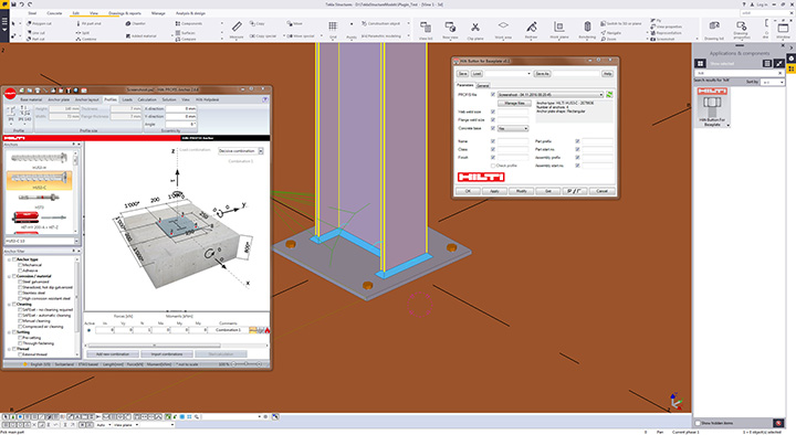
Trimble and the Hilti Group announced today that they are collaborating to deliver new software integration and data exchange solutions. These new integrated solutions provide a connected and improved digital experience for building construction professionals.
The Hilti PROFIS Plugin for Trimbe’s Tekla Structures.
New software and data exchange solutions include:
Sharing design information between software applications — Hilti PROFIS Plugin for Tekla Structures allows engineers and detailers to apply PROFIS design information directly in a Tekla Structures model through the Trimble Connect collaboration platform.
Easy access to data in the cloud — Hilti’s total stations POS 150/180 and PROFIS Layout Office solutions, and PROFIS detection solutions are now integrated with the Trimble Connect collaboration platform, enabling data to be easily exchanged and shared with others.
More design content, specification information and pricing at a user’s fingertips — Hilti has significantly increased its design content in the Tekla Warehouse to include anchors and cast-in solutions as well as providing more than 7,000 items through Trimble’s TRA-SER and LuckinsLive pricing services.
Since 2010, Trimble and Hilti’s relationship has been built upon shared values that focus on a deep understanding of customer needs and harnessing innovation to develop value-added solutions that increase customer productivity.
Hilti Corporation supplies the worldwide construction industry with technological products, systems, software and services.
As part of an ongoing commitment to transform the way mines manage their business, Caterpillar Inc. and Trimble are extending their collaboration to bring mining customers improved operational decision-making capabilities.
The collaboration will leverage Caterpillar Global Mining’s industry expertise and combine its in-pit operational execution system, Cat MineStar, with Trimble’s portfolio of technology-enabled mining information solutions.
This expanded collaboration in mining will include product integration and development, marketing, distribution and support of Trimble Connected Mine solutions.
The companies have signed an agreement that outlines areas for increased engagement to begin in early 2017. Caterpillar Global Mining is anticipated to become the primary sales, marketing, distribution and support channel for Trimble’s Connected Mine platform.
In addition, Cat MineStar and Trimble’s Connected Mine platform will be integrated and collaboratively developed. The expanded Caterpillar-Trimble collaboration will enhance both companies’ efforts to serve global customers with technologies and services across a mine?s entire operation and equipment fleet, regardless of brand, language or location.
“Caterpillar and Trimble have enjoyed a very successful relationship for decades and we are pleased to be working more closely to better leverage the products and capabilities in both companies for our mining customers,” said Tom Bluth, Caterpillar vice president with responsibility for the Surface Mining & Technology Division. “Whether it’s the mining pit supervisor or a corporate operational analytics teams, Caterpillar Global Mining continues to go beyond the iron by providing the technologies and expertise to help customers improve productivity and lower their cost per ton.”
“This collaboration demonstrates our mutual commitment to provide mine professionals with complete visibility from the mine to the mill,” said Bryn Fosburgh, vice president at Trimble. “As a result, mine operations can leverage accurate production, fleet and spatial data to optimize their workflow and control costs.”
Cat MineStar is a mining operational execution system purpose built to help miners boost productivity, enhance safety and improve equipment availability, regardless of equipment manufacturer. The system consists of five capability sets: Fleet, Terrain, Detect, Health & Command, which can be configured to suit the unique needs and capabilities of any mine, both surface and underground.
Cat MineStar has been a critical part of the digital transformation in mining since 1996 when it was first introduced. Today it is installed at more than 200 mine sites around the world. Utilizing improved interoperability, the Cat MineStar platform is uniquely positioned to help customers connect data and decision-making across the mining value chain, from the mine plan to plant processing or from an individual machine to across an enterprise.
Trimble Connected Mine provides an integrated and complete view of mine data to improve and accelerate operational and strategic decision making. Visual Intelligence is an optional module that enables the 3D visualization of Trimble Connected Mine data.
With a proven track record of enterprise-level implementations in some of the largest mines worldwide, Trimble is transforming the way mines work by combining mining expertise, spatial technology, business analytics, visualization and decision support tools to enable mining companies to fully optimize their resources for safe, productive and profitable mining.
Collaborating Since 1996. Caterpillar and Trimble have been collaborating in mining since 1996, when the two companies jointly developed a best-in-class machine control and guidance product, known today in the marketplace as Terrain. Today, Terrain is a leading guidance system for mining, with many of the world’s largest mining companies improving their productivity through use of this technology.
The companies’ first collaboration evolved into a joint venture in 2002 with the formation of Caterpillar Trimble Control Technologies (CTCT). Today CTCT develops machine control and guidance products for both the mining and construction industries, for any make or model of equipment regardless of manufacturer. Trimble positioning technologies, such as GPS and inertial navigation systems, are also used in many of Caterpillar’s semi-autonomous and autonomous systems.
Trimble is offering a new suite of services benefiting owners and operators of real-time networks (RTN): Trimble Network Management. The initial offering consists of three levels of service, ranging from simple backup to fully outsourced network operations.
Trimble Network Management is performed by Trimble’s global network operations team, comprised of network engineering, geodetic and IT professionals, already performing around-the- clock operations and maintenance in support of Trimble?s local and global networks.
Trimble Network Management is comprised of three levels of service, each one scalable and customizable to meet the requirements of the individual network owner.
Trimble Backup ensures users receive the highest possible level of uptime, maximizing productivity in the field. Trimble maintains a redundant network processor and server with 24/7 monitoring and support, and seamlessly maintains corrections to rovers in the event of a primary server failure.
Trimble Network Hosting brings RTN into the cloud using a fully redundant, decentralized data center. Network hosting can minimize the limitations of traditional IT solutions such as accessibility, server configuration and reliability.
Trimble Network Operations provides the expertise of the same Trimble network operations team trusted to maintain the Trimble RTX and VRS Now networks. Geodetic experts across the globe will monitor and maintain a RTN network 24/7.
Trimble Network Operations offers additional flexibility with resourcing, allowing RTN owners/operators to focus on their core competencies, or even expand into new horizons.
“Trimble Network Management is designed to reduce operating costs for the owner/operator,” said Patricia Boothe, general manager of Trimble Advanced Positioning. “And by leveraging Trimble’s team of network operations professionals as well as our scalable infrastructure, we can enable the private network owner to deliver improved network performance resulting in an enhanced end-user experience.”
Trimble Network Management is available today for RTN owner/operators using Trimble Pivot Platform network software.
Trimble has introduced Catalyst, a software-defined GNSS receiver that works with select Android mobile handhelds, smartphones and tablets. When combined with a small, lightweight, plug-and-play digital antenna and subscription to the Catalyst service, the receiver provides on-demand GNSS, geo-location capabilities to transform consumer devices into high-accuracy mobile data collection systems.
The announcement of the new product, designed for GIS professionals, was made at Trimble Dimensions.
Through smartphone and tablet developments accelerated by the bring your own device (BYOD) to work movement, field workers and consumers increasingly have access to positioning technologies for geospatial data use and collection. The Catalyst software receiver collects data and inspects or manages assets using smart devices. The software-defined GNSS receiver is designed to be integrated into a wide range of applications—providing a dual-frequency, multi-constellation receiver. The mobile device receives dual-frequency signals from the plug-and-play Trimble DA1 digital antenna. The small size and light weight of the antenna makes it possible to store in a car glove box or backpack, available for use on demand. By adding a Trimble Catalyst subscription, users can choose the level of accuracy to suit their application needs from meter level to centimeters.
Trimble calls its Catalyst service Positioning-as-a-Service. It is available on-demand. Users download applications to suit their business needs, purchase the low-cost DA1 digital antenna and subscribe to the level of service required for the application. For GNSS corrections, the solution automatically selects the best available correction service based on the user’s location and subscription level. Corrections powered by Trimble RTX technology and the Trimble VRS Now networks are supported. Trimble RTX corrections can be received either via IP/cellular connection or L-band satellite. The subscription cost is based on usage, allowing users to scale up/down for projects with minimal capital expense.
“The addition of Trimble Catalyst expands our portfolio to address the needs of organizations that have adopted a workplace Bring Your Own Device (BYOD) strategy for their businesses and individuals who periodically need accurate positioning to support various work activities,” said Ron Bisio, vice president of Trimble’s Geospatial Division.
TerraFlex Geospatial Data Collection. The first available application for the Trimble Catalyst service is the Trimble TerraFlex cloud-based mapping and GIS field software, enabling users to achieve up to centimeter-level accuracy. TerraFlex is a scalable cloud-based solution addressing a variety of field requirements including attribute-rich GIS data collection on consumer devices. With an intuitive interface and streamlined toolset for creating custom digital form templates, TerraFlex keeps the data flow standardized and streamlined from the field to the office.
TerraFlex provides a common interface for users across a range of common mobile and smart devices to provide robust, high-accuracy GNSS positioning and detailed asset attribution collection. The Catalyst service for TerraFlex provides a new option for a higher level of accuracy for users’ workflows without the upfront investment of traditional hardware GNSS receivers. It enables scaling up to meet specific project demands and allows a workforce to collect high-accuracy location in conjunction with other work tasks.
Availability. Catalyst service subscriptions and Catalyst DA1 antenna are expected to be available in the first quarter of 2017. In addition, a Software Development Kit (SDK) is expected to be available in the fourth quarter of 2016 for developers who are interested in developing new applications that use the Trimble Catalyst positioning on-demand service. Information and updates.
System equips the F-35 and unmanned aircraft with safer, more accurate landing guidance
The U.S. Navy has awarded Raytheon Company a $255 million contract for development and production readiness of its next generation precision landing system. The Joint Precision Approach and Landing System uses GPS satellite navigation to provide more accurate landing guidance for manned and unmanned aircraft, replacing radar and beacons used in older systems.
This contract, announced by the Department of Defense on Sept. 21 and Raytheon on Oct. 19, includes options which, if exercised, would bring the value to $270 million.
Raytheon will complete development for an auto-land capability to be used by both manned and unmanned aircraft, as well as finalize the integration with the F-35 Joint Strike Fighter: the first aircraft to be equipped with JPALS technology.
A U.S. Navy F-35C Lightning II lands aboard the aircraft carrier USS Nimitz in the Pacific. (Photo: US Navy)
When operational in 2018, the U.S. Navy and Marine Corps will use JPALS on the F-35C carrier variant, F-35B short takeoff/vertical landing variant and the MQ-25A multi-mission unmanned vehicle.
“The JPALS solution revolutionizes landings for manned and unmanned military aircraft,” said Dave Wajsgras, president of Raytheon’s Intelligence, Information and Services business. “Aviators will be able to trust this technology to provide safe, secure, and reliable landing guidance, at any time of day, in all kinds of weather and environments.”
Developed in partnership with the U.S. Navy to provide pinpoint landing guidance on carriers in rough seas, JPALS is tailorable to a wide range of environments including contingency operations requiring rapid deployment, or land-based airfields with curved, segmented and specialized approaches, and can integrate and modernize landing systems on legacy aircraft for joint interoperability.
JPALS improves navigational alignment prior to approach, allowing aircraft to land on any aircraft carrier or amphibious assault ship, day or night, even in adverse weather conditions. As the only military ground-based augmentation system in the world, the system features anti-jam protection to ensure mission continuity throughout a range of threat environments.
Trimble’s GCS900 Grade Control System is now available with xFill technology to sustain real-time kinematic (RTK) positions during correction outages.
xFill uses Trimble RTX technology, delivered via satellite, to “fill in” for RTK corrections in the event of temporary radio or Internet connection outages. As a result, contractors can experience fewer interruptions and less machine downtime.
The announcement was made at Trimble Dimensions.
The Trimble xFill technology maintains RTK-level accuracy during periods of radio or cellular interruption and will continue to extend RTK fixed positions with a gradual decrease in accuracy for a period of up to 5 minutes in construction applications. The technology provides seamless transitions between RTK and xFill. It functions by using the last known RTK position in conjunction with satellite-delivered RTX technology to sustain high-accuracy positions.
The xFill service is available throughout most of the world, in areas where Trimble RTX-based services are delivered via satellite.
“Contractors can now take advantage of improved RTK performance and reliability with the addition of xFill technology to the GCS900 Grade Control System,” said Scott Crozier, director of marketing for Trimble’s Civil Engineering and Construction Division. “Trimble xFill gives users who require uninterrupted connectivity and accuracy a more reliable solution, resulting in more machine uptime and fewer work stoppages.”
Telit has announced the commercial availability of the SL869-3DR, a GNSS module for global use that leverages information from internal gyros, accelerometers and a barometric pressure sensor to perform dead-reckoning navigation for application areas such as track and trace and in-vehicle systems.
The module delivers accurate position data either directly from its multi-constellation receiver or from a fully autonomous dead-reckoning system, requiring no connections to external devices or components other than an antenna for satellite signal reception and power.
The module allows integrators to design zero-installation, in-vehicle navigation and tracking devices for fleets and other commercial or consumer applications that operate perched on the dashboard, connected only to vehicle power.
The SL869-3DR is a flash-memory based module capable of tracking three constellations simultaneously. The module integrates an array of micro electromechanical systems (MEMS) designed to provide it seven degrees of freedom. The innovative design of the internal sensor array in conjunction with the Telit MEMS-only Dead Reckoning (MoDR) software and intellectual property, deliver the host device unparalleled portable, turnkey dead-reckoning performance.
The Telit MoDR solution ensures that reliable position, velocity and time information is constantly available to the host application even when GNSS coverage is compromised, without the need for connection to the vehicle for wheel-ticks for speed or reverse-gear data. Its standard footprint lets navigation and tracking system integrators reuse existing device designs, eliminating complexity from external sensors and other apparatus, getting to market quickly with updated designs or product innovation.
“A significant number of the millions of commercial vehicles and fleets on the roads today are still operating with no or unreliable navigation systems because installation costs to connect the device to vehicle sensors are too high and require very specialized skills,” said Felix Marchal, executive vice president of GNSS and Short Range Wireless. “With the SL869-3DR we overcome that barrier because it enables devices that you simply connect to vehicle power and go. Up until now, ‘power-and-go’ navigation systems have largely relied on open-sky visibility, which is not typically where most commercial fleets operate. They are moving through tunnels, urban canyons and other environments where these systems cannot produce a position solution. Reliable MEMS-only dead reckoning, or MoDR as we call it, relies on very complex mathematical modeling and expert design of the sensor array. Developers must therefore, thoroughly scrutinize performance of the different products in the market. I am delighted that the SL869-3DR has outperformed competing products in its class across a wide range of test cases.”
The SL869-3DR is designed to support GPS, QZSS, GLONASS, Beidou and is Galileo ready. Telit MoDR technology boosts position accuracy in areas with adverse satellite reception conditions like urban canyons, overhead foliage, tunnels and parking garages. It integrates an embedded array of sensors including accelerometers, gyroscopes and a barometer (pressure sensor).
An antenna ON, antenna sense (open / short circuit) feature, allows the host application to inform the user of problems with the connection to the external antenna. An additional LNA delivers better sensitivity in harsh environments, better enabling devices with integrated antennas. The module also features fast calibration and is pin-to-pin compatible with the SL869, SL869-V3 and SL869-ADR.
Below is a video where performance the autonomous SL869-3DR MoDR is compared with the SL869-ADR automotive navigation module connected to vehicle sensors (wheel ticks and reverse signal).
 Many contractors already use SketchUp Pro for layout and visualization. SketchUp’s affordable price point and ease of use make it an ideal solution for small site and utility contractors who do not have a software specialist on staff.