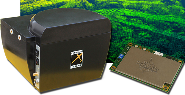
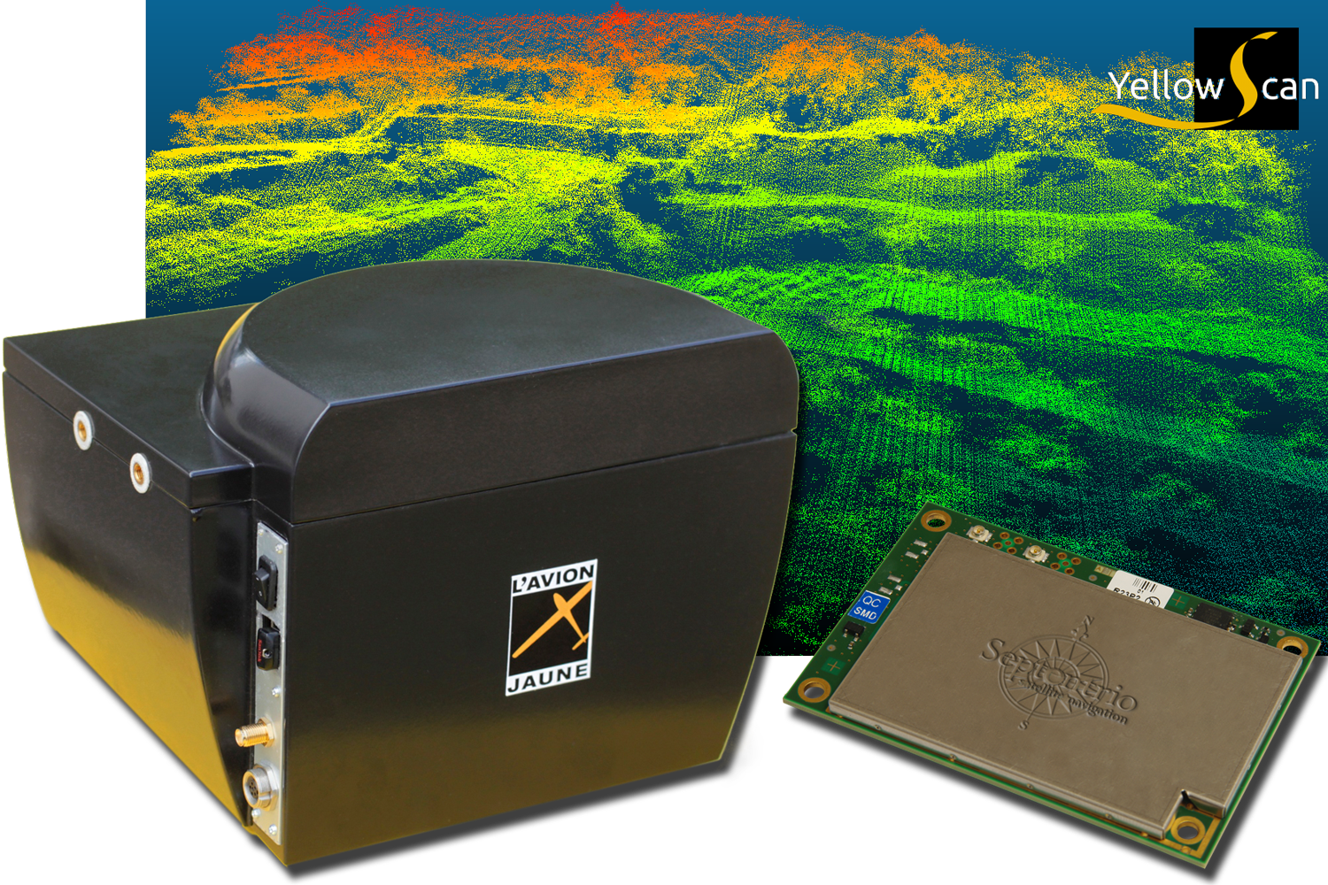
L’Avion Jaune, a service provider and airborne sensors integrator in the field of aerial surveys, has selected the Septentrio AsteRx-m to equip its YellowScan unmanned aerial system. L’Avion Jaune chose the AsteRx-m for its robustness and low-power consumption, Septentrio said.
YellowScan is the a lightweight all-in-one solution designed to deliver quality aerial surveys carried out using a LiDAR sensor aboard UAVs. The self-contained system integrates into a small package all the necessary equipment for conducting airborne surveys: a 3D laser scanner, an AHRS, a controller, an autonomous power supply module and the AsteRx-m, a high-performance precision GNSS receiver.
The AsteRx-m provides a compact and low-power solution for precise positioning in difficult environments where the tracking of both GLONASS and GPS satellites allows the receiver to improve the availability and robustness of a positioning solution. Septentrio’s newest RTK models optimally adapt to situations where GNSS signals can be distorted by reflective surfaces and feature unique countermeasures to disturbances, maintaining accurate and stable measurements wherever and whenever centimeter-level accuracy is needed, the company said.
“The easy-to-integrate AsteRx-m has proven to deliver the most reliable and stable RTK performance of all, in a compact and exceptionally low-power consumption module,” said Michel Assenbaum, CEO of L’Avion Jaune. “The AsteRx-m allows us to extend the operational range and capabilities of the YellowScan, a fully autonomous surveying solution dedicated to UAVs. We have tested the solution in various environments across the world and have never seen it falter.”
“We are delighted that L’Avion Jaune, a respected expert in designing unmanned-aerial remote sensing solutions, has validated the excellent performance of our ultra-compact GNSS receiver,” said Jan Van Hees, head of business development at Septentrio. “We are impressed to see how much interest YellowScan has drawn since its introduction and we are very proud to be contributing to the success of a best of breed solution in this highly competitive market.”
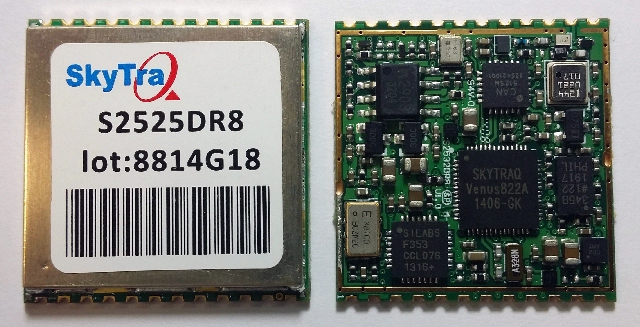
SkyTraq Technology, Inc., a fabless GNSS positioning technology company, has introduced an all-in-one S2525DR8 GNSS dead-reckoning module, with integrating MEMS sensor and interface logic on-board. The module is designed for road vehicles requiring high accuracy 100 percent positioning availability.
The S2525DR8 offers accuracy for both indoor and outdoor positioning. It is based on SkyTraq’s Venus 8 multi-GNSS platform and uses a high-performance automotive-grade XV-8100CB analog output gyroscope and 16-bit differential ADC. A 3D option adds a barometric pressure sensor on-board, offering improved accuracy for altitude reading and altitude change detection over an accelerometer-based scheme in 3D dead reckoning.
Another monitoring option adds an accelerometer on-board, offering high-accuracy vehicle acceleration monitoring for driver behavior characterization, accident reconstruction analysis, or trigger event recording. The S2525DR8 is compact at 25 x 25 millimeters. It contains a level shifter on board, capable of direct interface to a vehicle odometer and forward/reverse signals ranging from 3V to 30V.
The SPI interface pins on the module allow autonomous data logging to an external SPI Flash memory device. For high-performance vehicle navigation systems, S2525DR8 provides continuous navigation inside tunnels and underground parking lots without signals; highly accurate barometric altitude enables identification of which level the vehicle is on in a stacked multi-level high-way or a multi-story car park. For automatic vehicle locating or fleet management systems, location can be identified immediately after power on, whether the vehicle is outdoors or indoors under a signal-denied environment.
The S2525DR8 provides reliable, uninterrupted position, speed and heading information in challenging environments; it is suitable for demanding vehicle navigation and tracking applications requiring the highest accuracy and availability, SkyTraq said. The S2525DR8 is now being manufactured in ISO/TS 16949 automotive-certified factories; an evaluation kit, sample, datasheet, and reference design are available now. A 3D option with barometric sensor and a vehicle-dynamics monitoring option with accelerometer will be available in the first quarter of 2015.
Leica Geosystems has extended its Spider product family with the new GNSS Unlimited for the Leica GR10 and GR25 GNSS receiver series, allowing receivers to be upgraded to the latest technology standards at any time. Both receivers are designed for Continuously Operating Reference Stations (CORS) infrastructure and monitoring applications, supporting GPS, GLONASS, Galileo, BeiDou and QZSS.
Also, the classic Leica GRX1200+GNSS has been enhanced to support the Chinese BeiDou navigation system.
The Leica GR10 and GR25 Unlimited are scalable reference receiver and server solutions designed for permanent and semi-permanent GNSS network installations and monitoring applications such as RTK and static networks, single base stations, field campaigns, structural monitoring, atmospheric and seismic studies and offshore positioning.
One customer, the Michigan Department of Transportation (MDOT), took advantage of the future proof concept to provide cost-efficient and reliable data products for all its CORS users. MDOT has been working with Leica Geosystems since the beginning of 2000.
“Leica Geosystems’ customer commitment and promise of future proof hardware guarantee has always ensured our investment remains current,” said Shawn Roy, statewide survey equipment development manager at MDOT. “Their promise has allowed MDOT to upgrade, modernize, and expand our network from the early GRX1200’s (GPS-only) in 2005 to the latest GRX1200+GNSS. The company’s continuous development for hardware and software on our GRX1200 family of devices has helped MDOT over the past 10 years to provide cost-efficient and reliable data products for all the users of the Michigan Spatial Reference Network and other affiliated partners, such as NGS and its data products.”
GNSS Unlimited. High-precision GNSS users are faced with an ever-changing GNSS space segment, due to its modernization. According to Leica, the GR10 and GR25 receivers provide a safe and long-term investment for CORS operators and fully support the Chinese BeiDou and Japanese QZSS systems, as well as GPS, GLONASS, and Galileo. The GNSS Unlimited series includes an upgrade to more than 500 channels that will serve the users’ needs well beyond 2020.
Both receivers allow an upgrade of all key hardware parts, such as tracking, memory, power and communications. This enables customers to always keep up with the latest technology advances at minimum cost and only when really needed. The GNSS reference receivers act just like a data center server that satisfies all needs for a reliable operation, such as backup power supplies, redundant data communications, secured access and an easy way to monitor all the servers’ activities.
GRX1200+GNSS. First introduced a decade ago, the GRX1200 series is an example of Leica’s future-proof design with a newly released option to track the signals of the Chines BeiDou navigation system. Since 2004, customers have relied on the sensor’s innovation, allowing them to maintain and increase the value of their initial investment, Leica said.
Ready-mix concrete transportation has long been a challenge for the fleet industry, as concrete is subject to unique time and maintenance limitations to prevent hardening during transit. To improve delivery efficiencies and monitor the integrity of this temperamental cargo, Road King Technologies, Inc., a fleet management and automation company, has integrated Hirschmann Solutions antennas, a supplier of antenna and transceiver systems for M2M (machine-to-machine) and automotive communications, to develop a more reliable fleet data-collection solution.
“As we continue to find ways to provide more data collection benefits to our concrete transport customers, we’re creating strategic partnerships with innovators like Hirschmann, who can help advance our technology,” said Harry Marks, president of Road King. “Our relationship with Hirschmann has been — and will continue to be — a fruitful partnership for years to come.”
Using Hirschmann roof antennas, Road King is able to maintain the best possible cellular and GPS signal connection for its GPS-enabled solution, which is directly installed in concrete delivery trucks. The technology requires constant connectivity to upload data from the truck, including water usage, quantity control and dispatch wait times every 30 seconds. This information is processed by the server and sent to clients in a graphic format showcasing the delivery status of every truck. As a result, customers can review the processed information to improve and adjust their transport systems, boost driver reliability across their organizations and increase overall efficiencies.
“The complexities of delivering ready-mix concrete makes it vital that cargo data collection is constant and reliable,” said Frank Homann, president of Hirschmann USA. “With Hirschmann’s antenna, we’re working with Road King to ensure their data collection solution can optimally operate in any condition, including areas where cellular connectivity can be a major issue.”
Ready-mix concrete trucks work in some of the most extreme cellular environments, such as downtown areas where tall buildings can create urban canyons that block or interfere with cellular transmissions and GPS signals. In some cases, deliveries are made in new urban areas, where cellular towers are not yet installed and service, if any, can be intermittent, at best.
Road King’s data collection technology using Hirschmann antennas is certified by the PTCRB (PCS Type Certification Review Board), an organization setup by network operators to test GSM (global system for mobile communications) devices, such as mobile phones, modules and M2M devices. PTCRB certification is a requirement for launching cellular devices on North American GSM carriers.
u-blox has provided global positioning technology to Cohda Wireless‘ vehicle-to-vehicle (V2V) and vehicle-to-infrastructure (V2I) equipment, collectively called V2X. V2X will be a key technology for the next generation of advanced driver assistance systems (ADAS) as well as autonomous vehicles, the companies said.
Cohda’s DSRC (dedicated short-range communications) based V2X system uses accurate satellite positioning with embedded dead-reckoning technology provided by u-blox. The system enables early warning of imminent collisions, oncoming traffic, the presence of road workers and unsafe speed based on vehicles in the vicinity.
“Cohda’s V2X DSRC-based solutions make full use of u-blox’ advanced automotive-grade positioning technology to enhance driver safety through ample warning time and excellent non-line-of-sight performance. Such technology will soon be a standard feature embedded in all vehicles,” said Michael Ammann, VP platform partnerships at u‑blox.
“Our V2X vehicle warning systems are dependent on highly accurate position and velocity data to deliver the performance that is crucial to meet the safety demands of next generation cars,” said Fabien Cure, Chief Engineer at Cohda Wireless. “u-blox’ satellite positioning solutions, leading automotive dead reckoning technology, module roadmap and clear strategy to deliver lane accurate performance in challenging urban environments was convincing.”
In October, Jeremy Wood drove all over the United Kingdom to create a Halloween message, reports Metro. Wood drove a 10,000-mile, painstakingly-plotted route through England, Wales and Scotland in a Vauxhall Corsa, plotting a 264,000 positions on the car’s GPS. Wood linked the positions on a virtual drawing to create a picture that shows bats, ghosts, a spider web, and a pumpkin in a witch’s hat, with the word “Halloween” underneath. The result is the image below.
Photo: VB
Wood isn’t the first GPS-inclined artist. In 2013, a man in San Francisco equipped with an iPhone and tracking app rode his bike 27 miles around the city. Two and a half hours later, Payam Rajabi had etched a heart shape onto a city map.
Photo: VB
But the biggest devotee of GPS art could be Japanense artist Yassan, who in 2010 left behind his girlfriend for six months to travel across Japan, reports VB News. Carrying a GPS device, Yassan covered 7,163.7 km mostly by walking, but with some use of a car, ferry, and bicycle. He then used Google Maps to connect the GPS points he visited, resulting in this unique marriage proposal:
Photo: VB
Though he made the journey four years ago, his trek is now being featured in a new ad campaign and documentary by Hi-Tec, a company that makes hiking shoes and boots.
Yassan has been creating large-scale GPS drawings for years. Yassan was so inspired by the possibilities of GPS art that he quit his job in June 2008 to pursue his passion for making GPS drawings. Learn more about Yassan’s GPS Drawing Project on his website.
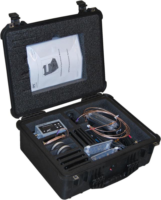
GPS Retransmission Kit by GPS Source. Photo: GPS Source
GPS Source has received a $7.5 million order for its GLI-COTTONMOUTH GPS retransmission kit from an international customer with an armored vehicle application. The kits will be used to provide armored vehicles with improved situational awareness. Shipments for the order are expected to be complete in the secondquarter of 2015.
“GPS Source is extremely pleased to be selected to provide the GPS retransmission solution for another one of our foreign military partners. Situational awareness, survivability and mission effectiveness are all improved by the use of GPS retransmission technology. Successful GPS Retransmission in the confined crew compartment of a military vehicle presents significant challenges, but one in which GPS Source has created the perfect solution,” said Robert Horton, CEO of GPS Source.
GLI-COTTONMOUTH is one of many GPS retransmission kits offered by GPS Source. The kits are available as permanent installs or man-portable. They provide GPS coverage within smaller military ground vehicle or aircraft. GPS receivers will experience no loss in signal coverage as they move out of a ground vehicle or exit an aircraft equipped with a tactical GPS retransmission kit from GPS Source.
GLI COTTONMOUTH and other GPS distribution solutions by GPS Source are in use by the U.S. Army and other military entities throughout the world. GPS retransmission technology developed by GPS Source is currently used by Net Warrior units aboard the Stryker, RG-33, and M1151. The technology is also used within the Canadian LAVIII and the French DGA SCORPION program.
Relevant GPS retransmission kits have received Safety of Flight Approval from the United States Air Force Mobility Command Systems Group and are used aboard the C17, C-130, CV/MV-22, CH-53 E/D/K, CH/MH-47, MH-60, HH60, and other host country aircraft.
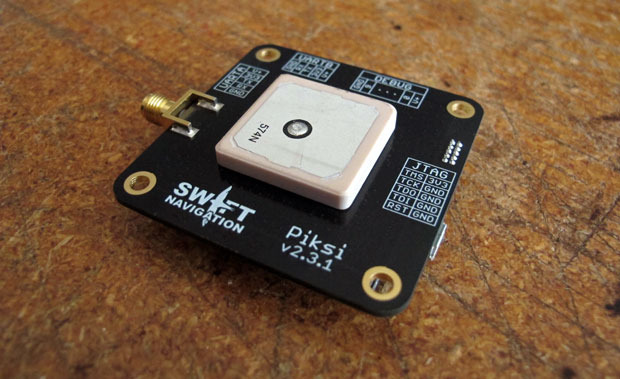
A little more than a year ago, Swift Navigation started a Kickstarter campaign for a $995 RTK GNSS receiver named Piksi. The goal was to raise $14,000 for the project. By the time the Kickstarter campaign was ended, Swift raised $166,097 from 303 backers.
I wrote an article about the Swift’s Kickstarter campaign in September 2013, a few days before the fundraising period ended. Following is a two-minute Kickstarter promotional video describing Piksi.
At the time, the $995 price for the Piksi raised a lot of eyebrows and generated conversations in the high-precision GNSS user community about inexpensive RTK technology.
This week, I took the opportunity to catch up with Swift to see how the project is going and where the company is headed.
I spoke with Tim Harris, CEO of Swift, and Fergus Noble, chief technology officer. Tim said they delivered most systems to their backers in April (2014) as well as issuing “very few” refunds, which is not unusual for Kickstarter projects. As of today, Tim said there are about 1,000 units in the field among 350+ users. He said they still consider the Piksi to be in beta testing phase and expect production units to start shipping next year.
“We are in RTK reliability mode now” — Fergus Noble
Fergus said that the hardware design is stable and hasn’t changed since they shipped Piksi last spring. He said the focus has been on refining the RTK firmware to make it robust and reliable for professional use. He admits that “covering all corners” has been a challenge and, according to Swift’s blog, “The RTK software has been a tougher nut to crack than we originally anticipated.” This is especially ambitious, since Swift said they developed the RTK firmware based on published academic technical papers, combined with their own techniques (preparing patent applications) to run on a low-power hardware platform. Basically, they started from scratch, and without any RTK veterans on their team. You gotta love their guts.
Apparently, the venture capital world liked what they saw. A few months ago, Swift, based in San Francisco, secured $2.6m in seed funding from Fall Line Capital, Felicis Ventures, Kal Vepuri, Lemnos Labs, Qualcomm Ventures and VegasTechFund. With the additional funding, Swift has increased its headcount from 4 to 9.5.
The Devil Is in the Details
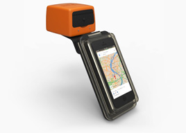
Swift Navigation Lodestar. Photo: Swift Navigation
Start-ups like these are a cool story, but at some point the rubber has to hit the road. Piksi is a long way from being an RTK product that you and I use for GIS and surveying, and Tim/Fergus are humble enough to admit this. The founders see the Unmanned Aerial Systems (UAS) market as their key customer base due to Piksi’s micro-size and low cost. They say this is reflected in their current customer base, which is comprised largely of UAS users, then surveying and agriculture, with the remaining 20 percent being a variety of apps like augmented reality. I agree that UAS is the right segment for them to focus on. At this point, the limitations for general surveying and GIS use are too great:
Must use a Piksi RTK base due to the proprietary protocol. In other words, not compatible with existing RTK base stations or networks.
Baseline length (distance between the RTK base and rover) must be very short. They haven’t done much testing even with a one-mile baseline.
RTK initialization is spec’d at 15 minutes, although Fergus said it’s typically 7-10 minutes.
Since Piksi is only a single-frequency receiver (L1), it has the same limitations as other L1 RTK systems we’ve seen marketed over the past few years — short baselines and long initialization times compared to dual-frequency receivers. While these limitations are significant for surveying and GIS users, they aren’t as significant for UAS users, since UAS users require line of sight to the aircraft at all times and UAS are operated in a clear-sky environment.
Communications
If you’ve used RTK, you are aware of the importance of data communications between the base and rover. As part of its kit, Swift supplies license-free, 915MHz frequency-hopping radios to facilitate communications between the base and rover for testing. However, the founderse make it clear that they aren’t in the data radio business. They expect that most Piksi users will incorporate their own communications technology. Swift is discussing incorporating GSM (mobile phone) modem capabilities in the future.
Future
In 2015, Swift plans to roll out the Piksi in production quantities, so Fergus said their focus is on creating a robust and professional RTK system. Of course, the burning question is if/when Swift will incorporate a second GPS frequency into its receiver to take advantage of the faster RTK initialization and longer baseline distances that a dual-frequency receiver offers. Swift isn’t willing to talk about that right now. Said Tim, “We’re holding our plans close to our chest.”
As part of European project MEDUSA coordinated by Telespazio (Finmeccanica/Thales), a workshop will be held in Tunis on Dec. 17 with stakeholders in civil aviation to promote the use of European satellite navigation systems in Libya, specifically EGNOS.
MEDUSA (Mediterranean follow-up for EGNOS Adoption) is a project funded by the European Commission as part of Euromed program GNSS with the objective of promoting the use of European satellite navigation services (E-GNSS), starting from EGNOS (European Geostationary Navigation Overlay Service) ahead of Galileo, in the Euromed area.
MEDUSA assists and prepares countries in the area (Algeria, Egypt, Jordan, Israel, Lebanon, Libya, Morocco, Palestine, Syria and Tunisia) in the adoption process of E-GNSS services, mainly in aviation as well as in other transportation sectors. To this end, MEDUSA implements a ”program of assistance actions” in countries from the area to transfer abilities, create technological capacities and share good practices.
Moreover, MEDUSA has created an operational and cooperation structure, called GEMCO (Galileo EuroMEd Cooperation Office), with a long-term working plan providing for the participation at a regional level of all beneficiary countries.
Located in Tunis, GEMCO acts as a reference point and catalyzer for all Euromed countries and towards Europe. Through GEMCO, MEDUSA favors initiatives connected to E-GNSS in the Euromed region, and contributes to the implementation of assistance actions of the project like national and regional workshops, training sessions, and days dedicated to studying.
GEMCO will host the MEDUSA meeting with stakeholders of Libya’s civil aviation to analyze the country’s needs, identify priorities and help define a strategic vision in the short, medium and long-term in relation to the possible operative introduction of the use of EGNOS. Libya, which has repeatedly shown interest in the project and EGNOS (whose perspective of availability of coverage of respective service is provided for in the short and medium-term), represents an opportunity for EGNOS mainly in the aviation and helicopter sectors.
The Geomatics Group, a Spectra Precision distributor and GIS software developer in Turkey, is achieving excellent success marketing the Spectra Precision MobileMapper 120 handheld GIS mapping device running Mobile GIS software developed by the Geomatics Group, according to Spectra Precision.
MobileMapper 120 uses a Windows open platform enabling it to run any Windows mobile application, including Spectra Precision applications for GIS or Survey, as well as third-party solutions that may better meet local regulations or specific customer requirements. The Geomatics Group has taken advantage of the Windows open platform to develop a specific application and integrated it with the MobileMapper 120 to provide a solution for its Turkish customers.
A Geomatics Group spokesperson says that sales of the MobileMapper 120 are particularly strong in three sectors in Turkey: mapping electrical infrastructure, orthophoto survey, and mapping public land and assets. Recently, 150 units of the MobileMapper 120 with the Geomatics Mobile GIS software were sold to the Turkey General Directorate of National Property to assist in public property management. According to the spokesperson, the sub-meter accuracy of the Spectra Precision MobileMapper 120 and the Mobile GIS software’s fast and easy menu access, hierarchical database and easily modified attribute library were important features in tests conducted by the customer. In another MobileMapper 120 sale earlier this year, 48 units were sold to the Provincial Directorates of Urban Environment for use in 48 different cities.
The spokesperson underscored the accuracy of the MobileMapper 120 that has impressed customers by reporting that one electrical grid customer who compared their ProMark 500 GNSS receiver to a MobileMapper 120, into which the Geomatics Group had installed a flying RTK option and using TUSAGA-Aktip (CORS-TR), found only a five-centimeter difference between the two receivers.
Dutch textile company ByBorre and its founder, fashion designer Borre Akkersdijk, have created the BB.suit — a wearable Wi-Fi hotspot with GPS, a music library, and an air purifier.
Version 1.0 of the suit, which has electrical threads woven into the fabric, was showcased at the SXSW music and film tradeshow in March, where a model’s location was shown on Google Maps, allowing anyone to locate the suit using its GPS data, and then upload songs to a 22Tracks platform.
Version 2.0 introduces an additional tech — an air purification system. Demonstrated at Beijing Design Week in September, the garment purifies the polluted air surrounding the wearer. According to Dezeen, designers Akkersdijk and Eva de Laat collaborated with Martijn ten Bhomer from the Eindhoven University of Technology, Daan Spangenberg Graphics, and StudioFriso to create the one-piece suit, which looks like an adult onesie.
“The BB.Suit started because everyone was talking about wearable technology, the bracelets, the glasses,” Akkersdijk told Dezeen. “We thought about how we could really integrate the electrical threads and sensors and not just stick them on.”
The electrical yarns are woven into the body and legs of the outfit, while the long sleeves and a hood are made from standard textiles. The air-quality sensor at chest level is connected to a hidden platform chip that tracks and transmits data counting the particles of carbon monoxide, methane and dust around the body. The chip is wired to a battery and a cold plasma node on the back of the suit.
You won’t be able to outfit yourself with the garment yet, as it was created as a step towards a connected wearable platform rather than a product to be marketed.
GPS World’s December cover story, “The Fashion Demands of Always-On,” discusses the chip architecture requirements of wearables. Read it here.
An Amazon employee picks items in the company’s newest generation fulfillment center. (Photo: Business Wire)
It used to be when you expected a home delivery, you could specify morning or afternoon, and hope you were there when the truck showed up. In today’s high-tech retail experience, van deliveries can be slotted specifically in two hour, or even one hour, windows. This is just one development in the battle for speed, as major retailers turn to technology to help Santa get presents under the tree on time.
According to a feature at BBC News, automated route planning and GPS tracking of vans has greatly improved deliveries, along with better warehouse scanning technology, such as the intricate robotic system employed by Amazon in its warehouses.
A Kiva robot moves product in Amazon’s eighth generation fulfillment center. (Photo: Business Wire)
The system uses robotics, Kiva technology, vision systems and almost 20 years’ worth of software and mechanical innovations to fulfill holiday orders. Amazon purchased the system in 2012 and tested it in 2013, but this is its first year for full deployment. Instead of having employees go to the shelves to find the items for an order, robots automatically deliver the items to them, hauling seven-foot-tall shelving units on their backs.
The robotic system has made picking products go two to three times faster, employees said.
The need for speed presents is a huge challenge for retailers trying to offer their customers a seamless shopping experience in-store, online and via mobile, the BBC reports. “Speed is the new battleground,” said Craig Sears-Black, UK managing director of Manhattan Associates, a software company specializing in warehouse management systems. “These days orders have to be processed in two hours, not two days. The physical side of selling needs to be optimized.”
In the UK, MetaPack handles the delivery of online transactions for 80 of the UK’s top 100 retailers, integrating about 240 delivery companies worldwide into its system. “These days competition amongst carriers is giving consumers a lot more choice over when and where their parcels are delivered,” said Patrick Wall, MetaPack founder and chief executive.
When a customer selects delivery options, MetaPack works out which are available in which location for which goods. MetaPack then decides which carrier represents best value for the retailer and handles all the tracking data so everyone can know exactly where the parcel is on its journey at any time.
In the U.S., FedEx is using enhanced visibility technology to help customers plan for package deliveries and pickups. At many FedEx ground facilities, high-speed six-sided camera tunnels with real-time package tracking updates scan every side of a package, enhancing the readability of a shipping label and providing visibility to a package’s location at all times.
That tracking technology, coupled with network-wide improvements, will offer customers increased visibility this season, including clarification as to exactly when a package is available for pickup at FedEx locations, FedEx said. It also will offer increased visibility into a package’s journey, from the time FedEx takes possession of the package to its estimated delivery date.