Category: Survey

  • Reflecting on 2013, from Your Perspective

    As the end of the year approaches, I’d like to reflect on 2013. One of the new features of the GPS World website allows me to access webpage statistics so I can understand which articles and news items were “hot.” Following is a list of GPS World magazine’s hot topics for 2013 with some commentary from me.

    Top 5 Most Popular Pages at GPSWorld.com in 2013


    1. GPS World Webinars

    While it seems everyone is conducting webinars today, GPS World was a pioneer in offering technical webinars more than six years ago, and they continue to be very popular today. Three of the latest webinars are:

    • Detect and Locate GPS Jamming
    • Unmanned Aircraft Navigation
    • What’s the Latest & Greatest? GNSS Products for 2014 and Beyond

    As a side note, I’m trying to talk the GPS World publishers into allowing me to host a bi-monthly or monthly 60-minute radio show hosted by myself and featuring various GNSS industry guests. The show would be an informal, roundtable discussion about current events related to high-precision GNSS and similar technology. It would likely be broadcast live over the Internet as well as recorded in MP3 format so you could listen to it using your smartphone or music device at a time convenient to you. Please send me a quick email if you think this is something you’d be interested in listening to.

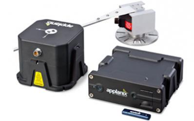
    2. RTK GNSS Receivers: A Flooded Market?

    I wrote this article in March 2013 discussing the myriad of new RTK receivers recently introduced. Since the article was written, even more have been introduced! Smaller, lighter and cheaper is where RTK is headed. The fact that this article was GPS World’s second most visited web page in 2013 speaks volumes of the growing interest in centimeter-level, real-time positioning (RTK).

    Just recently, my friends at the University of Texas at Austin (UT) took RTK where it hasn’t been before…on a smartphone.

    Dr. Todd Humphreys and his graduate assistants, including Ph.D. student Ken Pesyna, are part of the UT Radionavigation Laboratory. This team has been exploring, among other things, the feasibility of implementing RTK technology on smartphones. If you recall, in 2012 at the GPS World dinner during the Institute of Navigation (ION) GNSS Conference in Nashville, Dr. Humphreys proclaimed that RTK technology will be readily available on smartphones and tablets by the year 2020.

    Well, Dr. Humphreys and his team are doing their part to realize this vision. Just a few short weeks ago, he reported that they have enjoyed some initial success.

    However, before I present the details, I’ve been reminded several times over the years that smartphone GNSS chipsets aren’t the problem. In fact, two of the key GNSS engineers on the team (Broadcom) that designed the GNSS chipset used in the Apple iPhone, Dr. Frank Van Diggelen and Charlie Abraham, used to work for Ashtech. They know RTK.

    The challenge with implementing RTK in smartphones is the antenna, not the GNSS chipset.

    “The smartphone GNSS antenna is nothing more than a cleverly-designed wire trace, as are all smartphone GNSS antennas,” said Dr. Humphreys. “Some have joked that you could do better with a paperclip, and that’s probably not far from the truth.”

    Nevertheless, just a few weeks ago Dr. Humphreys and his team at UT were able to use a standard smartphone antenna (Samsung Galaxy SIII) to achieve an RTK solution. To his knowledge, this is the first time a successful RTK solution has been derived using an off-the-shelf smartphone antenna.

    UTSmartphoneRTK
    Source: University of Texas at Austin

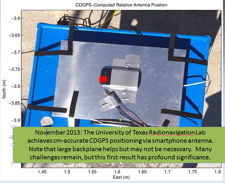
    Ken Pesyna added that RTK initialization took a little under seven minutes using seven satellites. He added that with 10 satellites in view he’s seen RTK initialization drop to about two minutes. Mind you, this is GPS L1-only. Certainly, the addition of L2, GLONASS would further reduce initialization times, not to mention BDS, Galileo, etc.

    So, RTK in smartphones next year? Not so fast.

    “Many challenges remain”, said Dr. Humphreys, “and in some senses we are cheating (big backplane, good clock). Nonetheless, this is a huge step forward that presages great disruption.”

    He added, “We were astonished to find that we could track L2C signals through the smartphone antenna. We didn’t exploit the L2C signals in our solution, but we could have, as the L2C carrier we recovered was quite clean.”

    Stay tuned…

    3. Seven Free Alternatives to OPUS GPS Post-Processing During U.S. Federal Government Shutdown

    Not far behind the RTK article, in web hits, was the article I co-wrote with Mark Silver on various free online post-processing services available to the general public. The article was super timely, as it was published a day after the U.S. government shutdown and the NGS OPUS website went blank. Therefore, thousands of GNSS users read the article in a very short amount of time.

    Photo: NOAA

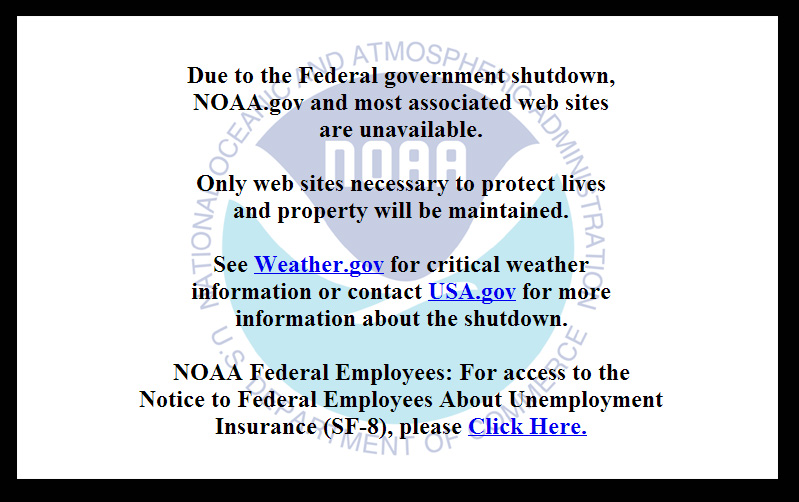
    Dr. Minghai Jia, a key developer of Australia’s AUSPOS online GNSS post-processing service, commented, “This is an excellent article, which has boosted AUSPOS demand significantly.”

    4. Look, No Base-Station! — Precise Point Positioning (PPP)

    Number four on GPS World’s website for 2013 was Tony Murfin’s article on the real-time PPP landscape.

    Whereas the real-time PPP landscape remained relatively unchanged for many years, with OmniStar and Starfire services being the only games in town for satellite-based precise positioning on land (as opposed to off-shore), this landscape is changing.

    In 2012, TerraStar began offering a commercial service very similar to OmniStar and Starfire — real-time decimeter positioning using corrections delivered via satellite (no terrestrial Internet connection required).

    Also in 2012, Trimble introduced its satellite-based RTX service, touting 4-cm real-time PPP accuracy.

    In April 2013, the IGS announced it began offering a public (free) real-time PPP decimeter service (IGS RTS). While only supporting GPS initially, IGS plans to support GLONASS by the end of 2013.

    The challenge for both TerraStar and IGS RTS is that receiver manufacturers need to integrate firmware to utilize these services. It’s unlikely that those companies offering competitive services that also design GNSS receivers (Trimble, Navcom) will do so, thus making it difficult for the new services to gain market traction.
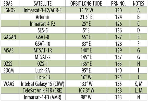
    5. The Almanac

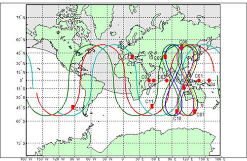
    Rounding out the Top 5 GPS World web pages of 2013 is The Almanac, featuring GNSS constellation tables compiled by Prof. Richard B. Langley at the University of New Brunswick.

    If you want a single, comprehensive webpage that lists all the navigation satellites from the various constellations, this is one you should bookmark in your web browser. Heck, there’s even a PDF version of it. GPS, GLONASS, Galileo, BeiDou, IRNSS, and public SBAS systems are listed in detail as well as many useful links to various GNSS resources.

    An updated Almanac will appear in the January issue of GPS World.

    Almanac-SBAS
    Public SBAS satellites

    Happy Holidays, and I’ll see you next year.

    Follow me on Twitter at https://twitter.com/GPSGIS_Eric

    If you are not quite feeling the holiday spirit, take a look at these wonderfully talented people in this four-minute music video. They don’t use any instruments besides their amazing voices.

  • Trimble Updates Cloud-Based Software, App for Wastewater Management

    Trimble has introduced a new version of its smart water and wastewater management software — Trimble Connect version 1.5. The latest release of the cloud-based software includes a suite of applications that help water and wastewater utilities to deploy smart meters, repair leaks and reduce non-revenue water (NRW), locate and map critical infrastructure using geographic information system (GIS) technology, extend the life of aging assets, and improve worker safety and productivity.

    Trimble Connect software version 1.5 can be configured and deployed quickly on a variety of rugged mobile devices, laptops, tablets and smartphones to automate field workflows and eliminate paper-based maps and field work tracking and management, the company said.

    Over the last decade, water and wastewater utilities have made investments in GIS mapping systems and asset maintenance management databases to manage their pipes and assets that are installed over large geographic areas. A large number of these utilities have implemented the Esri ArcGIS as their primary GIS mapping system. Maintenance of the information is an ongoing task and requires that information about the location of assets and the work performed on these facilities is accurately collected in the field. Trimble Connect helps with this challenge by integrating Esri ArcGIS technology and allowing utilities to view and update maps, assign work, manage workflows and collect field data and mapping updates using a variety of mobile devices. When used with a Trimble GeoExplorer series or Trimble Juno T41G series handheld, workers can map assets with up to decimeter accuracy in the field, helping improve the quality of their critical infrastructure GIS and asset management data.

    Trimble Connect integrates the latest Esri ArcGIS Server, mobile and ArcGIS Online map services. The software is designed to automate a variety of specific water and wastewater industry workflows through individual apps offered within the product. The new version provides standard core apps including Map Book, Meter Changeout, Leak Repair, Manhole Inspector, and Pipeline Mapper. In addition, an optional partner app developed for hydrant and valve inspection, called AFC Mapper, can be purchased from American Flow Control (AFC) and their distributors coupled with a Trimble rugged handheld.

    In addition to the standard core apps, Trimble Connect version 1.5 includes:

    • Multi-mobile platform support including Apple iOS, Android, Windows Mobile and Windows 7/8 devices
    • Offline support for Android, Windows Mobile and Windows 7/8
    • Esri ArcGIS based Web, mobile GIS mapping and ArcGIS Online basemaps
    • Work management support for single and multi-asset work orders
    • Business rules for customer mobile form design
    • Support for over-the-air network data and background map updates
    • Advanced spatial asset searching
  • Drone Moans and Satellite Woes


    As some of you may know, I also write a monthly column for Geospatial Solutions, which is all about geospatial technology encompassing GIS, surveying, engineering, and anything regarding geospatial technology. On occasion, I write something that fits very well with both my Survey Scene newletter and Geospatial Solutions Monthly newsletter. This is one of those months.

    Drones, UAVs, UAS…whatever you want to call them, are getting a lot of press coverage, both in the mainstream media and the surveying trade media. Rightly so — there are a terrific number of uses for drones in surveying and mapping from forensic mapping to crop monitoring to creating terrain models for volume estimations. A little later below, I’ll give you a link to my more detailed article about applications and my personal experience.

    In this article, I’d like to focus on the U.S. law regarding using drones for commercial purposes (eg. mapping, surveying, etc). I’ll start with a blanket statement.

    Under the current law, it is illegal for any commercial entity to operate a drone in the U.S. Period. 

    The only exception is that the Federal Aviation Administration (FAA) is issuing special airworthiness certificates in the experimental category for testing, market survey, and training of drones. However, the FAA specifically states that drone users awarded such an experimental certificate are not licensed to use drones for “hire or compensation.”

    The only other possibility is if the commercial entity has an airworthiness certificate for the drone like what’s required for any other aircraft such as an airliner. However, you can bet that no drone within your price range has such a certificate.

    What about hobby users?

    This is where it gets interesting and where some commercial users think there is wiggle room.

    Under the current FAA rules, hobbyists (the FAA calls them modelers) can fly drones up to 400 feet above ground level (AGL) and must notify the airport operator if flying within three miles of the airport. Hobbyists are covered under the AC 91-57 rules, a simple one-page document.

    Some (maybe many) companies and/or individuals who are operating drones for mapping in the U.S. think this is a loophole in the FAA rules, and that as long as they do not charge for the drone flight-time, they are not violating the FAA rules (they say they only charge for processing the data). The FAA begs to differ. When I asked the FAA this question, FAA Spokesperson Alison Duquette responded:

    “They would be violating FAA rules. Please read this policy link. The FAA recognizes that people and companies other than modelers might be flying UAS with the mistaken understanding that they are legally operating under the authority of AC 91-57. AC 91-57 only applies to modelers, and thus specifically excludes its use by persons or companies for business purposes.”

    This begs the question, is the FAA following a “don’t ask, don’t tell” informal policy? The best way to determine this is to look at their enforcement activity. When I asked the FAA if it would send me the list of enforcement activity regarding drones, the agency said I’d have to submit a Freedom of Information Act (FOIA) request, which I did this week. I’m told by my colleagues it may take some time before I get a response.

    I know of at least one instance where the FAA told an entity to shut down its use of drones. Take a look at this three-minute CBS news video.

    My Geospatial Solutions article “Is it Legal to Fly Drones for Mapping in the United States?” explores this topic in more depth.

    Let’s talk a little about RTK

    Last month’s article about post-processing alternatives, “Seven Free Alternatives to OPUS GPS Post-Processing During U.S. Federal Government Shutdown,” was one of the all-time, most-read articles ever published on the GPS World website. It’s ironic because I’m not a fan of post-processing in general. Mind you, I coordinated the development of several post-processing (both L1 and L1/L2) software packages back in the 1990s, so it’s not like I’m afraid to post-process or don’t understand the technology. It’s just that it’s so inefficient compared to RTK. However, I do concede that OPUS, AUSPOS, CSRS, Centerpoint RTX, GAPS, Scout, and MagicGNSS online post-processing tools combined with an increasing number of publicly available, worldwide GNSS reference stations make centimeter-level post-processing a lot easier (and less expensive) than ever before. It seems like a lot of you still prefer it!

    RTK technology is advancing too, from both a receiver perspective and a satellite system perspective. Which geographic region of the world do you think is the most well-suited for RTK positioning?

    It may seem like an odd question, and it would have been to me had I not attended the ION GNSS+ conference in Nashville, Tennessee, in September and the Intergeo 2013 conference in Essen, Germany, in October. How could one geographic region be significantly better for RTK positioning than another? Terrain? Nope. It’s the same country that consumes more L1/L2 receivers than any other country in the world: China.

    Why China? A picture (well, two pictures) is worth a thousand words:

    BDS
    BDS (BeiDou) orbit plot.
    Beidou_Navigation_Satellite_System_2012
    BDS (BeiDou) coverage map.

    At this point, China’s BeiDou (now referred to as BDS) navigation system is a regional system. If you look at the above graphic of the BDS satellite orbits, you can see the satellite figure eight orbits above southeast Asia. These satellites, combined with GPS and GLONASS, give the RTK user a tremendous number of usable satellites. Furthermore, since the BDS satellites are in figure-eight orbits, they stay “in view” longer ,which is ideal for RTK.

    The result is that GNSS users in the BDS coverage area have more satellites in view than any other region in the world, and we all know that more satellite observations make for better RTK positioning.

    China’s plans don’t stop with BDS being a regional system. By 2020, China says it plans for BDS to be a global system similar to GPS and GLONASS. The BDS presenter at ION GNSS+ said, “China always regards BeiDou belonging to both China and the world.”

    GPS and Galileo Delays

    Meanwhile, as it seems China is pushing forward, both GPS and Galileo suffered delays last month.

    The fifth GPS IIF satellite (IIF-5) launch scheduled for last month was postponed. A fuel leak in the Delta 4 launch rocket seems to be the culprit. No new launch date has been scheduled for IIF-5. The United Launch Alliance (ULA) issued the following statement:

    “The ongoing Phase II investigation has included extremely detailed characterization and reconstructions of the instrumentation signatures obtained from the October 2012 launch and these have recently resulted in some updated conclusions related to dynamic responses that occurred on the engine system during the first engine start event.

    “The GPS IIF-5 Delta IV launch is being delayed to allow the technical team time to further assess these updated conclusions and assess the improvements already implemented and determine whether additional changes are required prior to the next Delta IV launch.

    “The Delta IV booster for the GPS IIF-5 mission has completed the standard processing and checkout on the launch pad and will be maintained in a ready state for spacecraft mate and launch pending completion of this assessment. A new launch date will be established when the assessment of the updated dynamic response information is completed in the coming weeks.”

    Meanwhile, Europeans have been waiting on pins and needles for the first production launch of dual Galileo satellites. A fall 2013 launch date was expected, but has been postponed until Summer 2014.

    According to European officials, the European Space Research and Technology Centre (ESTEC) thermal vacuum chamber for testing satellites under orbit conditions was not ready for the two FOC satellites delivered by OHB in late summer.

    The satellites thus cannot ship to the Guiana spaceport in South America in time for a planned 2013 launch on a Soyuz rocket. The Galileo schedule is also running into bottlenecks with scheduled launches by other satellite programs aboard Guiana Soyuzes.

    A six-week test of the first Galileo satellite at ESTEC reportedly got under way in October.

    The pressure is rising for Galileo to start delivering usable satellite observations, which China is already doing, albeit for themselves and their neighbors.

    See you next month.

    Follow me on Twitter at https://twitter.com/GPSGIS_Eric

  • Applanix Brings Trimble CenterPoint RTX Correction Service to Airborne Mapping Products


    Applanix, a mobile mapping and positioning company, is making the Trimble CenterPoint RTX correction service available across its entire airborne mapping portfolio. Applanix is a Trimble Company.

    Using the Trimble CenterPoint RTX correction service, Applanix will be able to deliver these benefits to the aerial survey marketplace:

    • High accuracy — better than 10 cm RMS horizontal after convergence
    • Speed and low cost — no need for setting up base stations, no need to wait for delivery of public-domain ephemeris data
    • Simplicity — deal directly with Trimble (no third-party involvement)
    • More uptime and reliability — use Trimble’s professionally managed, highly maintained private network
    • Ease of use — there is no additional hardware to purchase, integrate or maintain
    • Fast and reliable convergence — 30 minutes or less to full accuracy

    The announcement was made at Trimble’s China Dimensions User Conference. The CenterPoint RTX service for Applanix airborne mapping products is expected to be available in the fourth quarter of 2013.

    “The Applanix aerial mapping portfolio is trusted throughout the aerial mapping community to provide highly accurate position and orientation information for directly georeferencing camera and sensor data,” said Joe Hutton, Director of Airborne Products at Applanix. “By integrating the Trimble CenterPoint RTX correction service, we are maintaining our position at the forefront of accuracy, robustness, and high efficiency in airborne mapping.  The CenterPoint RTX correction service gives Applanix products the  ability to achieve accuracy required for many types of mapping projects in real time and post-mission, all without the need for base stations – an industry first.”

    Trimble CenterPoint RTX correction service is a GPS, GLONASS and QZSS enabled correction service built on Trimble RTX technology.  It provides high-accuracy GNSS positioning without the use of traditional reference station-based differential RTK infrastructure.

    The solution is also compatible with the Applanix POSPac software to achieve the same level of orientation accuracy as when using base stations, all without the need to have an Internet connection or wait for precise ephemeris data to be available.

  • Topcon Acquires DynaRoad, Opens Technology Center

    Topcon Positioning Group has acquired DynaRoad Oy, a construction software company in Helsinki, Finland. In conjunction with the acquisition, Topcon also announced the establishment of the Topcon Helsinki Technology Center.

    In 2011, Topcon acquired a significant share of DynaRoad, a company that develops project management software specifically designed for large-scale construction projects — highway, tunnel, railway, area development and harbor.

    Ray O’Connor, Topcon president and CEO, said by acquiring 100 percent of DynaRoad, “Contractors and designers who are looking to cut construction costs through design optimization and better task management now have a strong central source for production management with DynaRoad being integrated to other Topcon systems. The new technology center in Helsinki has a strong foundation as the team has already worked with Topcon for approximately four years. We look forward to releasing new world-class products with them.”

    The DynaRoad software combined with Topcon’s Sitelink3D Enterprise, a real-time task management tool, creates “an integrated machine control solution for all phases of earthworks projects, from pre-planning to construction,” O’Connor said.

    Juuso Makinen, CEO of DynaRoad, said the acquisition “finalizes the close working relationship the two companies have had for years. This is a natural step to take as the integration of machine control and planning software enables us to automate many aspects of production management. Automating manual repetitive tasks such as task progress monitoring means our customers will have a better understanding of their site’s status and more time to spend on optimizing production.”

    “DynaRoad is a perfect fit to the Topcon organization,” said Ivan Di Federico, Topcon chief strategy officer. “The focus of their software and services is on construction economics — namely time and cost optimization. These products and experiences, together with Topcon’s machine automation and real-time communication, will bring our customers to the next level of productivity.”

    As a result of the acquisition, the DynaRoad products will be available through Topcon dealers worldwide.

    With the new Helsinki Technology Center, Topcon now has seven technology centers around the globe, including in Japan, Australia, Italy and Russia, plus two in the United States (Ohio and California).

  • NovAtel Launches Correct OEM Positioning Solution

    NovAtel Launches Correct OEM Positioning Solution

    NovAtel Correct.
    NovAtel Correct.

    NovAtel, Inc., OEM provider of high-precision GNSS positioning products, has launched its NovAtel Correct positioning technology. NovAtel Correct optimally combines data from multiple GNSS satellite constellations with corrections from a variety of sources, to deliver the best position solution possible.

    NovAtel Correct provides integrators with the opportunity to choose pricing and subscription options that best match their OEM business objectives. Delivery of correction data is available via satellite or Internet, depending on the requirements of the application. With NovAtel in control of the entire positioning solution, future innovation including seamless integration with all positioning modes and correction types is assured.

    Designed for NovAtel’s OEM6 high-precision receivers, the NovAtel Correct precise point positioning (PPP) solution delivers decimeter-level accuracy worldwide. L-band delivered PPP corrections from TerraStar are supported by NovAtel Correct without users having to add base-station infrastructure. Developers of land, airborne and near shore applications can purchase subscriptions to TerraStar’s correction service directly through NovAtel.

    “For a number of reasons, many of our customers have been eager for an end-to-end NovAtel OEM positioning service,” said Jason Hamilton, VP, Marketing for NovAtel. “NovAtel Correct rounds out our product and service offering and gives customers one-stop shopping for receivers, antennas and correction services.”

    Satellite and NTRIP-based solutions will be available for OEM6 products in Q1 2014 for all applications requiring decimetre-level positioning.

    NovAtel OEM628 triple-frequency +  L-Band GNSS receiver.
    NovAtel OEM628 triple-frequency + L-Band GNSS receiver.
  • Altus Makes Available Juniper Archer 2 Field Computer with APS-3 Receiver

    Altus Makes Available Juniper Archer 2 Field Computer with APS-3 Receiver

    Archer-2

    Altus Positioning Systems has announced the availability of the new Juniper Archer 2 field computer packaged with Altus’ APS-3 GNSS RTK receiver.

    “When paired with the performance, portability and flexibility of the APS-3, the new Archer 2 provides an unbeatable value proposition,” said Neil Vancans, president of Altus Positioning Systems. “This dynamic duo will allow surveyors to improve productivity by capturing data faster and staying in the field longer.”

    The Archer 2 is a powerful handheld computer with an IP68 certification and MIL-STD-810G compliance, and operates between -30 to +60 degrees C. It features a 1.0 GHz processor, 512 MB RAM and 8 GB flash storage. This second-generation instrument introduces an impressive line-up of new features, including the exclusive IllumiView brilliant display that overpowers the brightest sunlight, custom Overtime Technology intelligent Li-Ion battery yielding over 20 hours service between charges, and a glove-friendly capacitive touchscreen and keypad. As a successor to the popular Archer Field PC, the Archer 2 builds upon a  reputation of quality, adding big improvements and new features, Altus Positioning said. Like Juniper Systems’ other rugged handhelds, the Archer 2 is made to take a beating.

    The APS-3 has won accolades from surveyors for its accuracy, reliability and ease of use in the field. The 136-channel GPS/GLONASS RTK receiver includes an integrated quad-band GSM/GPRS modem, digital 406-470 MHz UHF transceiver and wireless Bluetooth connectivity. The flexible architecture allows the same device to be used either as a rover or base station. A popular feature is the dual hot-swappable Li-Ion batteries that allow field work to continue without interruption to change batteries.

    “We are excited to get the Archer 2 into the hands of our customers,” said Julie Johns, Project Manager at Juniper Systems. “We have designed the Archer 2 according to our customers’ needs, and we are very happy with how the final product has turned out. It feels great to send another new product out the door that we can be proud of.”

  • Trimble’s GeoExplorer GNSS Data Collection Adds Remote Positioning Capability

    Trimble’s GeoExplorer GNSS Data Collection Adds Remote Positioning Capability

    Photo: Trimble

    Trimble has introduced the next generation of its Trimble GeoExplorer data collection solution. The new Geo 7X includes an integrated laser rangefinder module, extended GNSS capabilities and improved hardware performance. Together with robust field and office software, the new Trimble Geo 7X handheld can enhance productivity in difficult physical conditions and challenging GNSS environments.

    When faced with either obstructed satellites or inaccessible locations, GIS professionals now have the geospatial data collection tools they need in a single package, Trimble said. For times when occupying a position isn’t possible, users can take advantage of Trimble’s new Flightwave technology. With Flightwave technology, users can capture offset measurements from the Geo 7X’s rangefinder module for direct integration with Trimble data collection software. Users point and shoot to log the position, avoiding dangerous conditions or right-of-way challenges. In addition, Trimble’s field-proven Floodlight technology enhances field productivity when heavy overhead cover obstructs satellite signals.

    Photo: TrimbleThe Geo 7X is compatible with existing and planned GNSS satellite systems — including GPS, GLONASS, Galileo, QZSS and BeiDou — to maximize productivity with additional satellites and ranging signals.

    Featuring a new 1 GHz processor and 4 GB of memory running Microsoft Windows 6.5 Professional operating system, the Geo 7X offers enhanced computing performance. Other standard features include a 4.2 inch sunlight readable LED touch display and a 5 MP camera for geo-tagging assets. For wireless connectivity, the integrated modem allows users to send and receive data via GSM networks as well as Verizon’s CDMA network in the U.S. And with its IP65 rating, the rugged handheld GNSS receiver is sealed against water and dust.

    With the introduction of the Geo 7X, Trimble also delivers updates to its field and office software portfolio to extend Trimble’s end-to-end data collection solutions with new software workflows and compatibility. In addition to the field-proven Trimble TerraSync and Positions software, the Geo 7X now supports the customizable data collection workflows of Trimble TerraFlex software. Consisting of mobile software and Cloud services, TerraFlex offers a fast and efficient way to collect, process and manage data. Field data is automatically synced with a central server to streamline office operations and drive higher productivity.

    ”We believe that true productivity is being able to map assets — the first time, every time and anywhere. We’ve built upon our productivity-enabling Floodlight technology and pushed it forward several steps,” said Alain Samaha, business area director of GIS and geospatial software solutions for Trimble’s Geospatial Division. “Users now can position themselves in the optimal location and accurately measure assets remotely with a single, integrated device together with simple software workflows. The Trimble Geo 7X allows mobile GIS users to be productive wherever they need to work.”

    Photo: TrimbleThe Trimble Geo 7X and supporting software are expected to be available in fourth quarter of 2013 through Trimble’s authorized GIS Distribution Channel.

  • Intergeo Post-Show Report


    The annual Intergeo conference and trade fair, this year held October 8–10 in Essen, Germany, elicited three principal observations from the three GPS World staff who attended:

    • Unmanned aerial vehicles, particularly in micro-form factor, have exploded across multiple sectors of the industrial economy. Emulating GPS — and carrying GPS on board in most cases — UAV has become an enabling technology with far-reaching implications.
    • Mobile devices bearing GPS/GNSS have likewise exploded, with many more commercial makers and models of handheld survey/mapping devices and location-enabled tablets to be found in Europe than in the United States.
    • GNSS manufacturers from China are making major efforts to secure distributors and break into the international market. Several had substantial booths, noticeably larger than the fewer, smaller booths present at Intergeo 2012.

    Like ION-GNSS+, Intergeo spans an industrial exhibit and a technical conference, but the emphasis in Germany is decidedly on the former.

    The technical conference covers key topics from a geoinformational perspective: environment, climate, energy, disaster management, cartography, spatial data, land policy, geographic information systems (GIS), and satellite processes and geodesy. About 140 presentations in 40 subject areas drew 1,300 participants — slightly larger than ION-GNSS+.

    But the real story here is the gigantic trade fair for geodesy, geoinformation, and land management, displaying GIS software and services, surveying equipment and accessories, data capture and processing, remote sensing photogrammetry, cartography, and much more — including a dizzying and frequently buzzing array of micro-UAVs.

    These face less regulation Europe than in the United States, which has still to come to grips with the technology. Federal Aviation Administration rules are expected in 2015.

    The 28,000 square-meter Intergeo exhibition space featured 505 exhibitors from 30 nations and drew an estimated 16,000 attendees from 80 countries — making it between eight and 125 times the size of the ION GNSS+ industry exhibit. Clearly, the German show has a different mission and a different mix of both exhibitors and attendees, spanning different bands of the GNSS application spectrum; and, its orientation is much more commercial.

    Exhibitors at the two shows form sort of an old-fashioned Venn diagram: some exclusive to either show and some overlapping, appearing at both. Among the latter group were: JAVAD GNSS, Trimble, Hemisphere GNSS, Leica Geosystems, NovAtel, Septentrio, ComNav Technology, Topcon Positioning Systems, and Fraunhofer Institute.

    Among GNSS companies showing in Essen but not in Nashville were Altus Positioning, AllSat GmbH, Carlson Software, CHC Navigation, Forsberg, Fugro Geospatial, and Hi-Target.

    A final question proffers itself after three days amid this hubbub: Why is there not a North American show of this nature? The Esri User Conference comes closest, but it is vendor-specific. There would appear to be a niche for a 5,000–10,000 attendee tradeshow in this sector.

    GPS World shipped 700 copies of the September issue to Intergeo; by the second morning of the three-day show, nearly all were gone, as attested by this note from our friendly bin stocker. Publisher Alan Cameron, Survey/GIS Editor Eric Gakstatter, and Associate Publisher Steve Copley attended, holding productive meetings with many exhibitors.
    GPS World shipped 700 copies of the September issue to Intergeo; by the second morning of the three-day show, nearly all were gone, as attested by this note from our friendly bin stocker. Publisher Alan Cameron, Survey/GIS Editor Eric Gakstatter, and Associate Publisher Steve Copley attended, holding productive meetings with many exhibitors.
  • Topcon Adds Vanguard Technology to GRS-1 Receiver

    Photo: Topcon
    Photo: Topcon

    Topcon Positioning Group has added Vanguard technology to the GRS-1 handheld GNSS receiver and field controller.

    “With the addition of Vanguard technology, the GRS-1 fully integrated, dual-constellation, network-enabled receiver and controller optimizes tracking and performance regardless of job site conditions or location,” Scott Langbein, director of product marketing, said.

    Topcon’s 226-channel Vanguard technology with Universal Tracking allows each individual GNSS channel to be fully optimized to track any of the available satellite signals that are supported in today’s GNSS receivers.

    The GRS-1 can be used in various configurations from handheld to network enabled RTK measurement, and grade management. “The system can be configured to perform at various levels of accuracy that fit any budget and application,” Langbein said. Choices include centimeter level, sub-decimeter and sub-meter, with accuracy upgradeability options available.

    Working with Topcon’s Magnet suite of software products, “the GRS-1 streamlines the workflow for surveyors, contractors, engineers and mapping professionals,” Langbein said.

    The GRS-1 with Vanguard has DGPS capability with the internal single frequency antenna for use in GIS and navigation applications. Add the external antenna and connect a GRS-1 rover to a local GNSS network, or Topcon Magnet Relay, for centimeter accuracy RTK performance. Magnet Relay allows a mobile base receiver to host up to 10 rovers through the Magnet Enterprise “cloud.”

    The GRS-1 has an optional 2MP built-in camera, integrated SD memory card slot, and includes an optional internal GSM or CDMA cellular modem and internal GNSS antenna, plus wireless connectivity via wireless LAN or Bluetooth technology.

  • Applanix Adds High-Performance POS Systems to Air and Land Portfolios

    Applanix Adds High-Performance POS Systems to Air and Land Portfolios

    Photo: Applanix
    Photo: Applanix

    Applanix, a mobile mapping and positioning company, has introduced new versions of its positioning and orientation systems for airborne and land-based mapping — the POS AV 610 and POS LV 610.  Delivering the same industry-leading performance as previous versions of POS AV and LV, the new systems use next-generation commercial inertial technologies that are offered globally.

    Applanix POS AV and LV products integrate precision GNSS with advanced inertial technology (accelerometers and gyroscopes) to provide uninterrupted measurements of the position, roll, pitch and true heading of moving vehicles.  Geospatial projects using POS can be completed more efficiently, effectively and economically. The POS AV 610 and POS LV 610 offer new advantages to customers:

    • Global availability: commercial technology.
    • Smaller and lighter: achieved by integrating a new state-of-the-art FOG (Fiber Optic Gyro) based Inertial Measurement Unit (IMU).
    • Exceptional performance with Applanix SmartCalTM software:  SmartCal is a new compensation technology designed to achieve unrivalled performance from IMUs manufactured specifically for mobile mapping applications.
    • Cost efficiency: exceptional accuracy, even in demanding conditions, at unprecedented price points.

    POS LV 610 and AV 610 are also available to systems integrators in the form of an OEM board set called the Trimble AP60. The Trimble AP is a series of embedded GNSS-Inertial OEM boards that provide both continuous mobile positioning in poor signal environments and high-accuracy direct georeferencing of imaging sensors.  The AP series is ideal for a variety of commercial mobile positioning and orientation applications including airborne and terrestrial mapping and guidance for unmanned vehicles.

    “The latest versions of POS LV and POS AV take Applanix’ state-of-the-art positioning technologies worldwide for land and air applications,” said Steve Woolven, President of Applanix. “Wherever mobile mappers operate, the new POS technology provides users with  accurate, reliable and robust position and orientation solutions.”

    POS AV 610, POS LV 610 and Trimble AP60 are available now through the Applanix sales network.

  • Altus Positioning Introduces GIS-1 for Data Collection

    Altus Positioning Introduces GIS-1 for Data Collection

    Photo: Altus Positioning Systems
    Photo: Altus Positioning Systems

    Altus Positioning Systems is expanding its line of GNSS surveying products with the introduction of the GIS-1, a versatile personal digital assistant (PDA) for data collection and geolocation.

    The GIS-1 is a powerful PDA that integrates modern wireless technologies on a rugged Windows Mobile platform for effective portable computing for mobile survey applications. It can be used as a data collection device with Altus’ APS-series GNSS survey instruments, providing up to eight hours of operation time in the field between charges. In addition, the unit’s built-in L-1 GPS receiver and 3.2 megapixel camera can be used for navigation and GIS applications. It can even be used as a smartphone.

    “The GIS-1 is a versatile tool for surveyors and GIS professionals,” said Neil Vancans, president of Altus Positioning Systems. “With the Windows  Mobile operating system, it supports a wide range of software applications for data collection. By itself, the GIS-1 is a convenient low-cost GPS navigation device with 2.5-meter accuracy.”

    “It’s ideal for GIS work,” Vancans added. “The user can quickly and easily locate assets with 2.5-meter accuracy with the GIS-1, then switch to the APS-3 for more precise RTK work if needed.”

    The GIS-1 supports a wide range of wireless options, including Wi-Fi, Bluetooth and a Tri-Band GSM/GPRS/EDGE/HSPA cellular modem.