Fugro’s Blue Essence, an offshore certified uncrewed surface vessel (USV) with an electric remotely operated vehicle (eROV), will begin its first project in the Netherlands.
The vessel is controlled from an onshore remote operations center (ROC) via a satellite connection. It will be used for the inspection of offshore assets, construction support services, and hydrographic and geophysical surveys.
USVs play an important role in the future of the maritime sector by improving safety, reducing carbon emissions, and delivering data more efficiently. USV operations remove personnel from high-risk offshore environments to an onshore ROC and reduce carbon footprint by 95 % when compared to traditional survey methods. Cloud-based data processing allows near real-time data delivery, leading to faster and more informed decision making.
“We welcome this special vessel in our port. It’s the first time a remotely controlled uncrewed vessel will go to the North Sea from the port of Rotterdam to carry out a project without any personnel on board,” said René de Vries, Harbour Master of the Rotterdam Port Authority. “We are proud that this project will be executed safely due to the careful preparation of all parties involved. We expect the development of digitalization in the shipping sector will improve the safety and accessibility of the Rotterdam port.”
Since 2020, Fugro has been deploying its Blue Shadow USV fleet for medium- to large-scale hydrographic survey applications. Fugro’s first Blue Essence has completed its first remote inspection, in Asia Pacific.
“I am excited that we now also have this newest generation of USVs available for European clients,” said Erik-Jan Bijvank, group director Europe and Africa at Fugro. “Over the coming years, Fugro will further expand its fleet of USVs for safer, more sustainable solutions for marine operations.”
A roundup of recent products in the GNSS and inertial positioning industry from the November 2021 issue of GPS World magazine.
OEM
Simulator
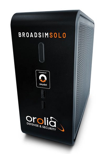
Designed for desktop convenience
Photo: Orolia
The BroadSim Solo has a compact form factor designed to fit comfortably at a typical desk or workstation. It shares the same Skydel simulation engine that runs on a standard BroadSim, BroadSim Anechoic and BroadSim Wavefront. It supports advanced scenario creation features and the benefits provided by a software-defined architecture such as high dynamics, a 1000-Hz iteration update rate and ultra-low latency of 5 ms. Nearly all civilian GNSS signals can be generated through the Solo’s single RF output (one frequency band at a time), along with jamming or spoofing signals, and GPS AES M-code.
Series offers GNSS, 5G NR, and wifi-6E combination
Photo: 2J Antennas
The Stellar series of antennas is designed for a large suite of devices with a focus on GNSS, sub-6 GHz, 5G NR, 4G LTE, 3G, 2G and WiFi-6E technologies. The series is suitable for law enforcement, medical transportation, fire rescue and other mission-critical applications. The series includes single or up to 9-in-1 configuration choices within the range of 617 MHz to 7125 MHz frequency bands. The patent-pending technology reduces the antenna footprint by 55% while implementing a new double trifilar design and longitudinal resonances for MIMO/ARRAY configurations that traditionally have more complex size restrictions (such as B71 band/600 MHz). Each antenna configuration uses symmetrical or asymmetrical resonators for negative sections of the antenna, resulting in maximum performance at low and mid frequencies.
The full-band GNSS HC990E embedded helical antenna is designed for precise positioning, covering the GPS/QZSS-L1/L2/L5, QZSS-L6, GLONASS-G1/G2/G3, Galileo-E1/E5a/E5b/E6, BeiDou-B1/B2/B2a/B3, and NavIC-L5 frequency bands, including the satellite-based augmentation system (SBAS) available in the region of operation [WAAS (North America), EGNOS (Europe), MSAS (Japan), or GAGAN (India)], as well as L-band correction services. The HC990E embedded helical antenna is designed and built for high-accuracy positioning. It is packaged in a very light and compact form factor, making it suitable for a wide variety of applications, especially lightweight UAV navigation. The HC990E is 60-mm wide and 25-mm tall, weighing 12 grams. It features a precision-tuned helical element that provides an excellent axial ratio and operates without the requirement of a ground plane. The HC990E also features a low-current, low-noise amplifier (LNA) and pre-filter to prevent harmonic interference from high-amplitude signals, such as 700 MHz band LTE and other nearby in-band cellular signals.
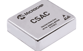
The SA65 chip-scale atomic clock (CSAC) provides precise timing accuracy and stability in extreme environments. Designed for military and industrial systems, it features ultra-high precision and low power consumption. The SA65 CSAC delivers higher performance than the previous SA.45s CSAC, including double the frequency stability over a wider temperature range and faster warm-up from cold temperatures. It has an operating temperature range of –40° C to 80° C and a storage temperature range of –55° C to 105° C. The warm-up time of two minutes at –40° C is 33% faster than that of the SA.45s. These performance improvements benefit designers of highly portable solutions for military applications such as assured positioning, navigation and timing (A-PNT) and C5ISR (command, control, communications, computers, cyber, intelligence, surveillance and reconnaissance).
Samsung Electronics is offering a new processor for wearables, the Exynos W920. The new processor integrates an LTE modem and is built with an advanced 5-nanometer (nm) extreme ultraviolet process node, offering powerful yet efficient performance demanded by next-generation wearable devices. The Exynos W920 is embedded with a GNSS L1 receiver (GPS, GLONASS, BeiDou, Galileo) for tracking speed, distance and elevation during outdoor activities. It also has a 4G LTE Cat. 4 modem. It has two Arm Cortex-A55 cores for high-performing, power-efficient processing and an Arm Mali-G68 GPU with CPU performance improved by 20% and 10 times better graphics performance than its predecessor. The Exynos W920 supports a new unified wearable platform that Samsung built jointly with Google, and will be first applied to the upcoming Galaxy Watch model.
The Arrow Gold+ and Arrow 100+ expand upon the features of the Arrow Gold and Arrow 100. The Arrow Gold+ has a battery life 3.5 hours longer, for a total of 11 hours of field autonomy. It supports concurrent use of BeiDou B3 and GPS L5 signals when using RTK corrections, and the upcoming Galileo E6 High-Accuracy Service (HAS). The Arrow 100+ has a battery life 6 hours longer than the Arrow 100, for a total of 18 hours of field autonomy. It also supports Atlas H50 (Basic) service subscriptions, which provide 30-50 cm positioning accuracy worldwide when no SBAS or RTK network is available. Both the Arrow Gold+ and Arrow 100+ use Eos Bridge to connect with external sensors — multiple mobile devices can connect to a single Arrow GNSS receiver via Bluetooth.
EagleView’s high-resolution ortho and oblique imagery now can be converted into 3D mesh layers with Skyline’s PhotoMesh and viewed, edited and analyzed on Skyline’s TerraExplorer platform. EagleView customers will be able to use Skyline’s TerraExplorer web-based GIS viewer and editor to see, analyze and share their imagery in an immersive environment. Accurately measuring distance, area and volume is now easier than ever, which is critical for planning and zoning to verify regulations or estimate the costs of flattening a site. With floodplain analysis, disaster management can identify flood risks before they happen, and with viewshed calculations E911 can pre-plan for high-profile events. Other key analytic features for customers include the ability to analyze shade, view contour and slope maps, and view in underground mode. The additional 3D Mesh capability is available as an add-on to any new Reveal Essentials+ Property or Neighborhood image capture.
The KlauPPK Phone App, designed for use on drones with KlauPPK hardware and software, enables users to collect ground survey points with a name, description, feature code and antenna height like a traditional survey controller. The app sends the information to the operator’s computer for processing with the raw GNSS data logged in the KlauPPK unit on the pole. After post processing, the accurate survey data can be brought into CAD software to create points and line strings. The app takes a photo of the point being captured, and metadata is collected in the project. Users can place ground control points or check points, pick up as-built data like roads and utilities, and perform basic surveying. The system is compatible with the hybrid PPP/PPK MakeItAccurate post-processing service.
TerraLens 9.3 is a real-time software development toolkit for geospatial visualization. This release improves performance for 3D visualization for large viewports and multi-domain visualization features for command-and-control applications. It is significantly faster to enhance situational awareness. With increased multithreading in its map handling, TerraLens can load and display vector, raster and elevation formats smoothly without pre-processing, suitable for applications with disk size constraints or customers with a short turn-around time. A pre-processing option is still included. Improved data culling ensures only visible items will be rendered — especially noticeable when displaying large numbers of dynamic tracks and objects. New tools and features including support for OGC 3D Tiles for cityscapes, and a new API to control resolution of terrain mesh. Elevation warnings can now be displayed.
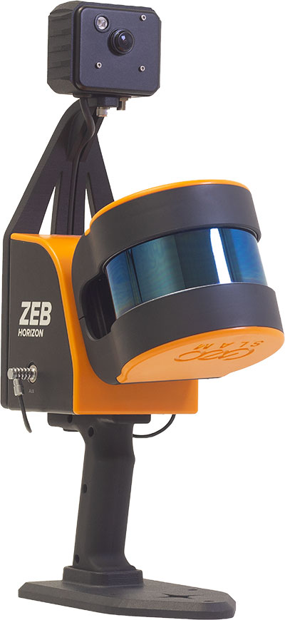
The ZEB Vision 16MP panoramic camera is now available for pre-order. Suitable for any ZEB Horizon, the new camera provides better colorization, image walkthroughs and point-cloud measurements using optional Draw software. Further updates mean GeoSLAM customers now can take a ZEB Horizon from handheld to UAV usage to get a more complete picture of projects. ZEB Horizon is compatible with the DJI Matrice 300 UAV.
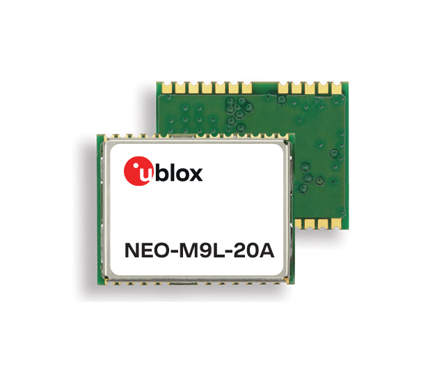
A new series of automotive-grade positioning modules are operational up to 105° C (221° F). The NEO-M9L modules and the M9140-KA-DR chip are built on the u-blox M9 GNSS platform and use dead-reckoning techniques to provide accurate position data when satellite signals are compromised or unavailable. The NEO-M9L-20A and NEO-M9L-01A modules, as well as the M9140-KA-DR chip, are specially designed for first-mount automotive solutions. The NEO-M9L-01A variant offers an extended operational temperature range up to 105° C, making it suitable for integration on the roof, behind the windscreen, or inside hot electronics control units. Applications include integrated navigation systems such as in-vehicle infotainment (IVI) and head units, integrated telematics control units and V2X.
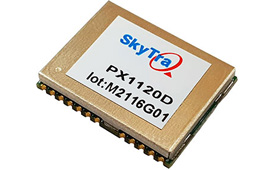
Provides positioning accuracy in tunnels, parking garages
Photo: SkyTraq
The PX1120D GNSS/inertial measurement unit (IMU) is suitable for both automotive pre-installation and aftermarket. The robust dead-reckoning module integrates a six-axis IMU and a concurrent quad-GNSS chipset. It receives signals from GPS, GLONASS, Galileo and BeiDou, as well as QZSS. The sensor-fusion module maximizes positioning accuracy in challenging environments, providing continuous navigation in tunnels and underground parking lots. For automotive pre-installation applications where vehicle wheel-tick signals are available, the PX1120D provides wheel-tick sensor fusion with automotive dead-reckoning. In aftermarket applications where wheel-tick signals are unavailable, the PX1120D provides an untethered dead-reckoning sensor-fusion solution. A single PX1120D module provides both automotive and untethered dead-reckoning functionality, simplifying logistics. It is suitable for infotainment systems, telematics control units, vehicle tracking, and advanced driver-assistance systems.
The Trooper Max 5G FR1 antenna platform is a 5G configurable and low-profile antenna platform for intelligent transportation and public safety applications. Configurable and optimized for multiband applications, the platform includes an option to add land mobile radio connectivity through an external whip port. With a slender shark-fin form factor, the Trooper Max is recommended for installation on public safety fleets. It is compatible with cellular routers supporting 600-MHz to 6-GHz frequencies. It also covers Wi-Fi 6 frequency ranges.
Version 7.9 of the CompassTrac fleet and asset management solution provides winter fleets with more detailed spreader controller information and greater insight through enhanced dashboard and reporting functions. Features include integration of numerous spreader controllers for granular, pre-wet and liquid materials; a snow-fighting dashboard consolidating key performance indicators; and a snow materials report that delivers historical reporting of granular, pre-wet and direct liquid material application rates and totals, including air and road temperature (where available). The fleet-management solution integrates GNSS, GIS and wireless networks, enabling end users to view the real-time locations and status of vehicles, people, and other high-value assets for full situational awareness.
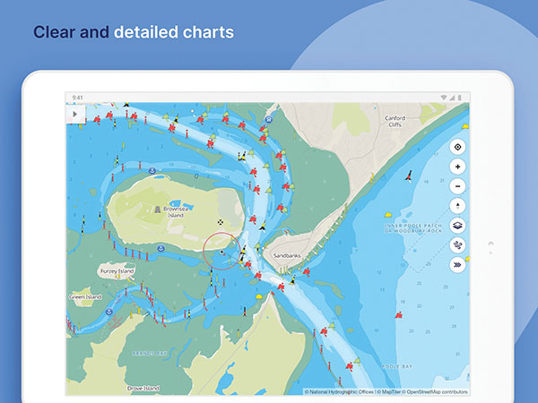
New departure scheduling charts route, wind, tides
Photo: Savvy Navvy
Smartphone app Savvy Navvy now allows boaters to plan better by visually showing the best time to depart given wind and tidal implications, leading to more informed and cost-saving decisions for journeys. By comparing passage times, as well as weather and tide information, boaters can immediately make crucial decisions based on safety, comfort, time and cost. Savvy Navvy is available on Android, iOS, PC and Mac and can be used on an unlimited number of devices simultaneously. It charts, weather, tide, marina details and passage planning with full tidal vectors. Active GPS tracking shows vessel position and enables boaters to instantly check course over ground (COG) and speed over ground (SOG). The app uses UKHO, NOAA and other official hydrographic charts from around the globe, as well as tide data from 8,000 tidal stations.
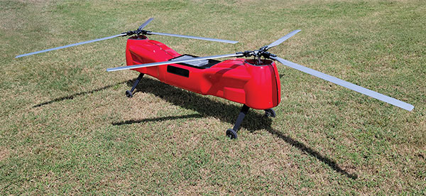
The Anzen EG-1250 provides a heavy lift, multi-drop, long endurance and flexible platform, expanding the services and operational support offerings from UAS Global Services. With an endurance of six hours, the EG-1250 can carry 75 pounds, cruise at 65 knots, in any weather day or night. The EG stands for an electric and gas dual-engine configuration, with the secondary engine able to power the aircraft or act as a power boost for the primary Skypower rotary SP-180 SRE engine. The Anzen EG-1250 is auto-rotation capable and offers an optional safety parachute system. The flexible platform can support industries such as maritime, agriculture, oil and gas, utility, cargo delivery and intelligence, surveillance and reconnaissance (ISR).
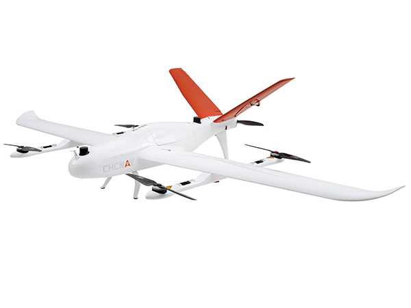
The P330 Pro is a high-performance vertical takeoff and landing (VTOL) fixed-wing UAS for aerial surveying and mapping. It provides high accuracy, long endurance and multiple payloads. It features a 100-Hz differential module, which allows aerial mapping operations at the centimeter level, and a flight endurance with payload reaching more than 150 minutes. The P330 Pro can be used to conduct small- and large-scale aerial surveys with extreme data quality, and is an alternative to manned aircraft for surveying and mapping, mining, construction and infrastructure, environmental monitoring and agriculture.
Capability expansion enables M300 for data capture
Photo: Skycatch
Flight1x software now provides data-capture capabilities for the DJI Matrice 300. The Skycatch High Precision Package provides mining operations with cloud or edge-based data processing that enables viewing terrain in 4D, automated RTK/PPK industrial drone management, and fast edge processing with data visibility in minutes. Built on technology adopted by large mining companies, Flight1x includes purpose-built flight automation software for the M300, leveraging DJI’s L1 and P1 sensors. Flight1x is part of the Skycatch High Precision Package, which provides mining operations with cloud or edge-based data processing that enables viewing terrain in 4D, automated RTK/PPK industrial drone management, and fast edge processing with data visibility in minutes.
Offers 5G and artificial intelligence capabilities
Photo: Qualcomm
The Flight RB5 5G platform is designed to accelerate development of commercial, enterprise and industrial drones. Powered by the Qualcomm QRB5165 processor, it condenses multiple complex technologies into a tightly integrated drone system. With 5G and Wi-Fi 6 connectivity, the platform enhances critical flying abilities beyond visual line-of-sight to support safer, more reliable flight. High-performance computing provides power efficiency for artificial intelligence and machine learning, enabling fully autonomous drones. A secure processing unit supports cybersecurity protections. New camera capabilities deliver premium image capabilities and performance. The Flight RB5 5G drone reference design is available through ModalAI. Use cases include mapping, inspection, film and entertainment, defense, security and emergency response, and delivery.
Spirent GNSS Foresight lets operators know where and when unmanned vehicles, air taxis and drones can operate safely and dependably beyond visual line of sight, especially in urban areas where buildings frequently obstruct GNSS signals. The cloud-based solution can produce forecasts using data from any of the world’s satellite constellations, and is of particular interest to the aviation, UAS and automotive industries. Spirent GNSS Foresight’s ability to accurately predict where and when autonomous systems will perform enables users to scale operations or services by expanding operational areas, reducing the number of system disengagements, and providing a greater level of safety and reliability assurance when reducing — or ultimately removing — human involvement in the driving or piloting task.
If we introduce children who have an interest in visualization of puzzles, art and mathematics to the appropriate training methods, we can help train future STEM students that could turn into our next generation of surveyors and geospatial professionals.
Many of us who were children before computers, the internet, and lots of electronic gadgets used our imagination to create fantasy worlds and environments. Many of these visions were drawn on paper using pencils, crayons and paints to recreate those images so we could share them with others. While the world in which we live, work and play exists in three dimensions, our minds were kept to a two-dimensional level because of how ideas and visions were made possible only on flat surfaces or media.
Photo: Tim Burch
Surveying has been no different through the centuries. Surveyors have generally divided their work into two categories: land boundaries and topography. Typically, the surveying process of parcel establishment and retracement has been a two-dimensional task, while topographic surveys utilize elevations to determine relief and drainage patterns. This survey information was drawn as graphic depictions on paper to provide the pertinent data to users. It has been generally impossible to express survey data, including boundaries and topography, in a three-dimensional form as the human eye sees it. Many different professions have tried to present information beyond the second dimension but with little success.
The beginning of the imagery revolution
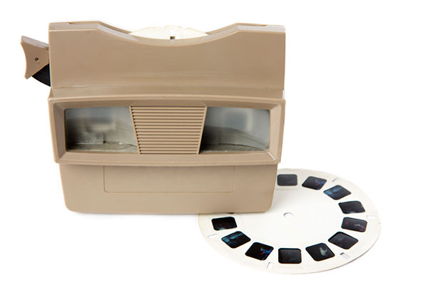
In the 1800s, the invention of photography brought a new medium into our world by capturing images of still life onto a two-dimensional format. Photographs, when taken at a proper angle and lighting, helped establish depth to an image, but only if taken in the right context and for the correct purpose. The 1830s brought us the stereoscope, utilizing two slightly different versions of the same photograph to be viewed through a binocular device and “tricking the brain” into establishing depth within the image. This is one of the first examples of using a visual technique to teach our brain to gather 3D information based upon a 2D image or dataset.
The 1800s also brought us the “motion picture” or movie as we traditionally know it. Ranging from 16 to 24 frames per second and using varying methods to “flash” through a sequence of progressing images, the movie brought another new medium into our world. While silent films were the predominant movie type, several inventors conceived varying ways to produce movies in three dimensions. The most popular type was the stereoscope movie, but moviegoers found it too cumbersome to sit behind a stationary set of stereoscope glasses for the length of the film.
Another innovation from the 1890s was the creation of the anaglyph. This viewing style required glasses with a red lens for the left eye and a blue lens for the right eye to view two negative images that form a stereoscopic subject. These images remained popular well into the 20th century, with the concept crossing over into films.
It is one thing to see an object in real life and make a mental note of what it looks like from varying angles. It is another thing to accurate depict the same object on a two-dimensional medium that gives the viewer the same perspective of the real object. Artists who can simulate depth on an otherwise flat media with drawings and paintings are rare; one of the most famous is M.C. Escher (1898–1972), a Dutch artist known worldwide for his “impossible” drawings and sketches based upon mathematical figures. He had a gift of seeing his art in three dimensions and translating it to various mediums.
But not every drawing is an artistic interpretation. Ideas that come to fruition in an inventor’s mind often get drawn to scale on paper for sharing with others. Mechanical engineers often used a system known as isometric drafting, a method of drawing a three-dimensional item to join an isometric view, giving the shape within the drawing a sense of depth.
Toys and games as training tools
Little did we realize as children and young adults that many of the inventions for imagery led to many popular toys in our history. For instance, the View Master was invented in 1938 and widely introduced at the 1939 New York World’s Fair. This toy turned the stereoscope concept into a sightseeing treasure. In the 1960s, the photographic reels viewed within the View Master began featuring television, movie and cartoon characters in various storylines. It is estimated that more than 1.5 billion reels have been produced covering sites and subjects from every corner of Earth.
There have also been many variations on the optical illusions designed to make one see a certain image, then suddenly see something completely different. One significant entry in the illusion category is Magic Eye, a series of images based upon single-image random-dot stereograms, or autostereograms. These images utilize computer graphics to “hide” a 3D image within patterns of other shapes and trick your brain into focusing on the hidden subject. After more than 25 years and hundreds of millions of copies of its books, Magic Eye is still challenging people to “see” objects in three dimensions.
However, the biggest training device for seeing 3D objects in a 2D medium happened within the same timeframe and has no plans for slowing down any time soon: video games. The video game platform has reinvented itself several times in its short life, but the premise behind the visualization remains the same. Some of the systems allow for virtual reality glasses or goggles to enhance the user’s experience.
“Yes, in fact, my child is gifted…”
The scientific term for this visual ability is called spatial intelligence. Spatial intelligence has and attracted attention in recent years for helping determine a person’s strengths and capabilities. Spatial intelligence, also known as spatial reasoning, is one of the nine intelligences in the Theory of Multiple Intelligences proposed by psychologist Howard Gardner. In his theory, Gardner challenged the narrow definition of general intelligence with his proposal of nine types of intelligences:
spatial
linguistic
logical-mathematical
musical
kinesthetic
interpersonal
intrapersonal
naturalistic
emotional
Often, we know people who display various traits as defined within this list of intelligences. Someone with linguistical intelligence is well-spoken, enjoys reading and writing, and can explain a situation or story well. A person with logical-mathematical intelligence solves difficult computations and is a tremendous problem solver. Musical intelligence is found in one who is a “natural” at playing a musical instrument or singing. The pattern continues with the rest of the list and helps to establish strengths within one’s abilities. Most of the intelligences are born within a person, while a few can be somewhat taught. Finding the people with the strongest abilities in a given trait leads us to the highest performers.
Spatial intelligence is observed in those who like to draw, design or build things, and are quick to mentally manipulate objects to solve puzzles. David Lohman, a researcher who has spent most of his career studying the subject, defines spatial intelligence as “the ability to generate, retain, retrieve and transform well-structured visual images.” Individuals with highly developed spatial intelligence have a unique ability to view objects and imagine them in rotated positions or different angles, and how a group of items can fit together.
How important is spatial intelligence as a teachable subject?
In the past, having spatial intelligence was a naturally occurring trait. Important figures in history, including Picasso and da Vinci, are a few examples of individuals with high spatial intelligence. Clinical research, however, has determined this ability to be a skill that is actually trainable in many instances. If we introduce children who have an interest in visualization of puzzles, art and mathematics to the appropriate training methods, we can help train future STEM students that could turn into our next generation of surveyors and geospatial professionals. By employing a spatial component into lessons and challenging students through visual tasks, they begin to identify objects and other matter into geometrical patterns and spatial relationships. Students who display these spatial characteristics are better at critical thinking and problem solving, which in turn gives them more self-confidence.
Another important characteristic of spatial intelligence is that gender does not play a large role. Studies have shown that with training and a challenging curriculum, both boys and girls are prone to excel at gaining more spatial awareness and ability to solve problems. The key to maintaining this equality in spatial intelligence is to provide equal education and training for both genders in the formative years. Often, only boys are steered toward sports, math and science while girls are directed to the arts and humanities. By providing all children with the opportunity to experience spatial learning, they will begin to build skills that will help them for a lifetime.
What does spatial intelligence have to do with GNSS and surveyors?
It has everything to do with geospatial data! Literally all survey data collected these days is geospatial in nature and contains three-dimensional coordinate values. Why is the evolution of seeing 3D objects in 2D spaces so important? Not everyone can visualize these shapes immediately in two dimensions. If we are able to identify those with strong spatial intelligence levels, we can steer them into the many variations of geospatial fields and surveying.
Previously, our surveying profession dealt with data collection in small doses. A good day of topographic surveying might see a crew collect 1,000- to 2,000 points. (Not to mention the days before data collectors!) Because the area covered within the day’s work was significant, the surveyor did not have to look at a “big picture” of terrain and improvements. These smaller chunks, even though they were collected with elevations, were plotted in 2D. The contours drawn using the points were simply grade proportions between points and did not produce a 3D effect.
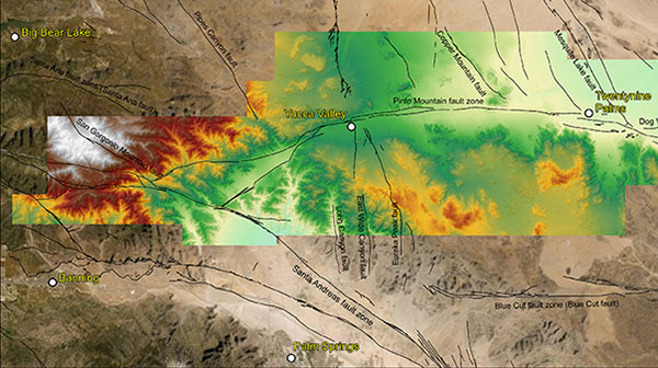
Lidar data collected in May 2021 for a study of the San Andreas Fault system. (Image: Stephanie Dudash, USGS)
Fast forward to the surveying instruments and CAD software in today’s work environment. Remote sensing through UAV-mounted, vehicle-mounted and terrestrial-based instruments collect thousands to millions of points (per second in most cases), and we get the resulting point clouds produced by these instruments. It is equally important to see the spatial relationship of the terrain, improvements and overall site conditions for both the surveyor and the CAD technician. We now have data that literally blankets the surface of the subject site, and it is up to both field staff and office staff to correctly interpret that data for the prospective client. Having surveyors and technicians with a reasonable sense of spatial intelligence gives the data a better chance of correct interpretation and depiction.
Many STEM industry experts are beginning to work with researchers on creating more educational curriculum based upon the various intelligence categories previously discussed. Spatial intelligence will continue to increase as an influencing factor in helping students decide on their career choices. Having our educational system also increase the amount of spatial relationship curriculum within their core teachings, we can help grow our potential STEM professionals and technicians for generations to come.
While many professions and occupations continue to struggle in anticipation of their future need for employees, the surveying and geospatial professions can help do something about it now. Encourage your kids to play video games, fly their drones, play sports, and solve complex problems. Playing and learning today may help them with their future profession. If not, they can enjoy themselves while they can. Don’t we all wish we were kids again some days?
Bad Elf LLC and Laser Tech are providing an integrated laser offset workflow for acquiring high-accuracy field data in GNSS-challenged environments.
The new workflow integrates Bad Elf and LTI hardware in collaboration with ArcGIS technology from Esri.
The Bad Elf Flex GNSS receiver connects to any LTI TruPulse rangefinder over a wired or Bluetooth connection to deliver high-accuracy location data to Esri ArcGIS Field Maps. Field workers can now efficiently complete position and height data collection in access-limited situations, saving time, money and effort, the companies said.
“This collaborative integration effort empowers field data collectors to focus their time, energy, and budget on creating and maintaining their systems of record, instead of troubleshooting systems integration issues,” said Larry Fox, vice president of marketing and business development at Bad Elf. “As Esri Partners in the Esri Partner Network, we are pleased to collaborate with LTI in offering a straightforward workflow to our customers.”
“The ability to capture height measurements of an asset expands the data collection capabilities and ability to add more attribute data to the remote asset,” said Derrick Reish, senior product manager at Laser Tech.
Bad Elf’s app workflow focuses on enhancing productivity, reducing field collection difficulties, and mitigating quality issues. The Bad Elf app workflow runs on Android and iOS. Connection versatility minimizes operating system limitations and allows for app-based or standalone operation. Bad Elf also provides free Esri ArcGIS Desktop and ArcGIS Pro tools for offset-enabled point feature capture using the currently available ArcGIS Field Maps for iOS.
“The Bad Elf Flex, when paired with an LTI TruPulse rangefinder and ArcGIS Field Maps, delivers a powerful data collection solution,” said Esri Product Lead Jeff Shaner. “The innovative checklist-driven workflow delivers an intuitive, streamlined experience for advanced field workflows and the ability to provide a height calculation unlocks new opportunities for data capture.”
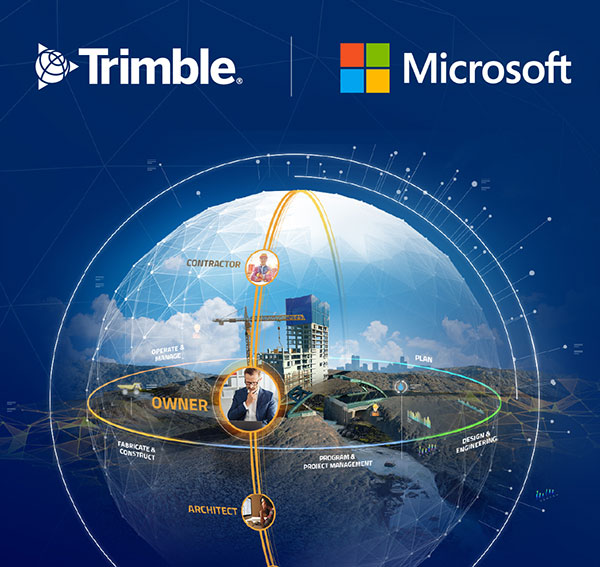
Companies to develop an industry cloud to enable construction organizations to harness digital construction data across the project lifecycle
Trimble and Microsoft have entered a strategic partnership to advance technology adoption and accelerate the digital transformation of the construction, agriculture and transportation industries.
By leveraging the Microsoft cloud, Trimble and Microsoft will collaborate to develop, build and deliver industry cloud platforms and solutions that connect people, technology, tasks, data, processes and industry lifecycles. The collaboration represents a significant milestone to advance Trimble’s Connect and Scale 2025 strategy, which centers on building cloud platforms.
Initially, Trimble and Microsoft will focus on building the Trimble Construction Cloud powered by Microsoft Azure.
Image: Trimble
The construction process is fragmented, which can result in lost productivity, rework and a lack of transparency. According to a McKinsey & Company article*, the construction industry is lagging with only 1 percent productivity growth over the last 20 years — significantly lower than the 2.8 percent for the total economy.
Digitization of products and processes is expected to drive change in the industry. The ability to link technologies, tasks, processes and multiple stakeholders — general contractors, subcontractors, designers, engineers and owners — across the construction project workflow can transform and significantly improve productivity, quality, safety, transparency and sustainability, according to Trimble.
The partnership expands Trimble and Microsoft’s existing relationship to combine the Microsoft cloud with Trimble’s construction solutions and industry domain knowledge. Trimble’s construction solutions include on-machine and field technology, modeling and collaboration software, project and resource management, and all underlying analytics.
The Trimble Construction Cloud, expected in 2022, will be fully enabled for 3D constructible models that will reduce risks, drive speed and increase efficiency and accuracy across the construction project lifecycle, including designing, building and operations.
The companies will also partner on go-to-market strategies and solutions to enable continued support of infrastructure investment cycles, and be used for large-scale projects, on which multiple stakeholders work in parallel to deliver connected construction projects.
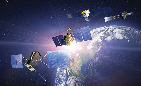
The tremendous benefits of having four complete GNSS constellations
In 2020, with the completion of China’s BeiDou-3 (aka BDS) and Europe’s Galileo, the number of available global navigation satellite system (GNSS) constellations doubled.
Analogously to the addition of GLONASS to GPS a quarter century earlier, but much more so, this sharp increase in the number of available satellites and frequencies greatly improved the precision of satellite-based positioning, the speed of first fix, and the confidence in the results — especially in GNSS-challenged places, such as under thick canopy and in deep urban canyons.
Additionally, this new ability to track three or four GNSS constellations makes the overall positioning solution more resilient to malicious RF interference (jamming and spoofing), to accidental GNSS service disruptions such as Galileo’s one-week service outage in July 2019, and to deliberate withholding of service such as might occur in times of war.
While all this may make little practical difference to a driver needing to know which highway exit to take or to a pedestrian looking for the nearest pharmacy, it is very valuable in high-end applications, such as surveying and construction. In fact, surveyors who have transitioned to using all the available constellations are ecstatic.
This month’s cover story, on the benefits of having four complete GNSS constellations, is in two parts. First, Oliver Montenbruck and Peter Steigenberger discuss “the practical relevance and implications of having four GNSS in parallel for both mass-market and high-end users.” Next, I present the comments of three surveyors and a receiver manufacturer:
Gavin Schrock, PLS, is a practicing land surveyor, the operator of a cooperative real-time GNSS network in Washington state, and a technology writer
James Richards is the senior land and utility surveyor at Benchmark Surveys in Venny Bridge, UK
Choice Sterling is the survey manager at Kiewit Corporation in Federal Way, Washington
Xiaohua Wen is the CEO and founder of Tersus GNSS, a manufacturer of GNSS surveying receivers based in Australia.
(Satellites from left) GPS: In July 1995, GPS achieved full operational capability (FOC). GLONASS: In December 1995, the (then) Soviet system achieved FOC. BeiDou: On June 23, 2020, China launched the final satellite of the BeiDou-3 constellation. Galileo: The constellation has 21 usable satellites.(Credit: Satellites from public sources; background image: NASA/Chaykovsky Igor/Shutterstock.com)
James Richards Senior Land and Utility surveyor Benchmark Surveys, Venny Bridge, UK
James Richards, Benchmark Surveys
What kinds of surveying projects do you run?
We run many different types of surveying projects. From small single-story bungalow extensions and redevelopment to development of new home sites of several hundred acres. We cover land, underground utility, and measured-building surveys of any size project, using the latest equipment in total stations, laser scanners, drones, GPS receivers, ground-penetrating radar (GPR) and electromagnetic location (EML).
How have you transitioned to using multiple constellations?
Ordnance Survey benchmarks in the UK are no longer maintained. Therefore, it has been a must to move forward with the surveying world and use multi-constellation GNSS equipment. We have stayed at the forefront of GNSS receivers, starting with a Topcon GRS1 then moving onto a Trimble R10 and a Topcon HiPer SR. Now, I feel we’ve taken another leap with the Trimble R12i, working in areas where we previously did not even consider using a GNSS receiver.
How does the availability of four complete GNSS constellations, plus two regional ones, benefit your work?
The availability of four complete GNSS constellations and two regional ones gives us more reliability as well as improved position and time accuracy in the data that we receive. It also gives us better coverage over the entire UK, including near buildings and under foliage. The Trimble R12i has 672 available channels, which makes it future-proof to new frequencies and additional space vehicles.
Choice Sterling Survey manager, Kiewit Corporation Federal Way, Washington
What kinds of surveying projects do you run?
I am the survey manager on $1–3 billion mega projects, ranging from bridges and highways to tunnels and rail, including a couple of projects for the U.S. Department of Defense.
How have you transitioned to using multiple constellations?
The use of multiple constellations became available as we adopted technologies that could capitalize on their availability. Through the latest hardware and software, we have begun leveraging GNSS to a greater magnitude than we would have just a few years back.
How does the availability of four complete GNSS constellations, plus two regional ones, benefit your work?
Not long ago, the use of GPS for construction staking was an extremely risky proposition given its unreliability, primarily in the vertical component, and lack of confidence in its horizontal accuracy. With residuals exceeding most construction tolerances, GPS was primarily utilized for earthwork or to establish geodetic pairs that could then be traversed to establish control for more precise work. With the utilization of multiple GNSS constellations, we have gained confidence in the accuracy of our results and have started leveraging GPS for construction staking where we were once not willing to take the risk.
Having the ability to leverage GPS under a canopy of trees or against structures or walls has proved invaluable when running traverses or levels, typically enabling us to use a single person rather than a two-person crew. Increased confidence in repeatability and accuracy while using GPS has been a game changer when working on projects where efficiency and cost management are of the greatest importance.
How have you transitioned to manufacturing multiple-constellation GNSS receivers?
Early in 2016, we produced a GNSS receiver evolution road map to take advantage of GPS/GLONASS modernization, the continuing development of Galileo and QZSS, and the completion of BeiDou-3. In 2019, we released our current GNSS receiver, which has 576 tracking channels and supports all five major GNSS constellations (GPS, GLONASS, Galileo, BeiDou-3 and QZSS) and triple-band broadcasts (GPS L1+L2C+L2P+L5, GLO G1+G2+G3, GAL E1+E5a+E5b, BDS B1+B2a+B2b and QZSS L1+L2C+L5). We expect to release our next generation receiver, with 832 channels, in February 2022. It will support all available constellations (GPS, GLO, GAL, BDS, QZSS, IRNSS/NavIC, SBAS) and all civil signals, including the AltBoc and AceBoc.
How does the availability of four complete GNSS constellations, plus two regional ones, benefit your end users?
The most significant advantage of modern GNSS receivers is their robust high-accuracy performance with the aiding of the new constellations and signals, especially in harsh GNSS environments, such as deep canyons and heavy foliage. It greatly extended the RTK fix capability, and now reliable GNSS RTK fix solutions can be easily achieved in areas where it was impossible to do in the past.
In the past, multipath always has been a problem for RTK GNSS receivers, as it might cause blunder errors. The improved RTK fix reliability based on robust RTK integrity monitoring takes advantage of the redundancy of observations to identify and isolate deteriorated observations and confirm the fixed result. Additionally, RTK achieves RTK fix solutions faster and maintains the RTK fix solutions easier with better accuracy than before.
Compared to the dual-band (L1+L2) of GPS plus GLONASS, the triple-band (and multi-band) can allow long-range RTK capability, which can provide reliable RTK solutions with a remote GNSS base station far from the 20–30 km base and rover separation of the past. It also will provide more confidence in RTK positioning during the coming ionospheric disturbance peak in 2023.
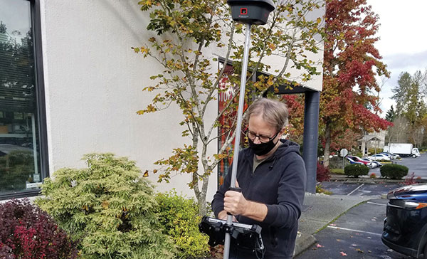
Gavin Schrock, PLS, shared his thoughts on how the evolution of GNSS has affected surveying. Schrock is a practicing land surveyor, the operator of a cooperative real-time GNSS network in Washington state, and a technology writer.
Gavin Schrock has been using satellite navigation since the early days of GPS and the Doppler-based Transit system before that. “I am a bit of a dinosaur,” he said. “What I find interesting about the evolution of GPS, especially when it went to multi-constellation, is that it instills more confidence in what somebody is doing, in several ways.”
For commercial use of GPS, the first units were static and required post-processing. “If you were out in the wide open sky and could get your minimum of four to five satellites and observe enough data, you could process that and get outstanding precision — less than 3 cm in 3D in a reasonable amount of time with 95% confidence,” Schrock said. “Now, with more satellites, you can get it a lot faster and in more places.” Using certain procedures, early GPS adopters could get down to millimeters. “You can get that precision now, but you get there a heck of a lot faster.”
An obstructed view of the sky, tree canopy, multipath and other factors limit where surveyors can use GNSS. One of the ways the new constellations and signals help, Schrock explained, is through the evolution of processing. “I like to call it the fourth wave of GNSS field equipment for high precision — for surveying, machine control and construction. In just the past few years, many of the manufacturers have had to put huge processors in their high-end rovers to process many more satellites and signals, as well as new RTK [real-time kinematic] engines with improved onboard multipath mitigation.”
While some rovers built a decade ago could track and use many of these signals, this new wave of gear, with more powerful processing, takes much greater advantage of the multi-constellation. The updated interface control document (ICD) for BeiDou-3 was released just over two years ago; it may still take a lot of development work to enable older receivers to take advantage of it, if it is even possible, he said. By contrast, “Many newer units hit the ground running with full constellation capabilities.”
“Much of the new wave can do amazing things in the way they can mix and match signals, though there are different approaches to this,” Schrock said. “They can do such things as processing many satellites and multiple signals from each, under one filter for a more robust solution. You might have L1, L2, L5, B3, E1, E5a, and E5b in the mix, to name a few. Then you have the alternative BOC modulation (AltBOC), where it is kind of processed together to give a wide lane solution. That can really bring in your high precision a lot faster and, in many cases, improve on the high precision that you used to get with your old rovers.”
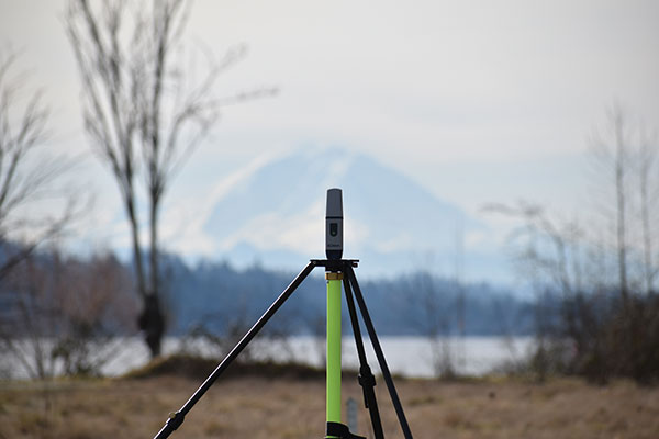
Mount Rainier (above) serves as the backdrop for a field project by Schrock (right). (Photo: Gavin Schrock)
How GLONASS Brought Change
Surveyors using equipment more than four years old, which Schrock calls “legacy gear,” often cannot take full advantage of the availability of multiple constellations. “Years ago, there was a mini-boost when manufacturers began to include GLONASS; you suddenly had more satellites. Early GLONASS was a mess, but it got better. It remains a little noisy, but you have extra satellites. When you are trying to get a minimum of five satellites to do your RTK or your network RTK, we really struggled when it was GPS only. GLONASS changed that. You could work in many more places, without worrying about the time of day and looking up what the satellite’s availability was going to be and have to plan ahead.”
The latest boost, thanks to the two new GNSS constellations, is “much more impactful” than the addition of GLONASS was, Schrock said. Galileo now has five or more usable signals, depending on how each manufacturer chooses to use them. In addition to the extra satellites, “you also have more modernized signals. They are not as noisy as the old GLONASS ones. GPS signals are still very clean, and about half of the GPS satellites now broadcast the L5 signal, which you can throw into the mix.”
RTK units now can mix and match satellites from different constellations in outstanding ways, Schrock said. “The advantages are great when you are struggling in canopy. You still must be cautious, but you can check repeatability much more quickly.”
GNSS today: A four-leaf field test of a South rover with MicroSurvey software. (Photo: Gavin Schrock)
In the old days, Schrock recalled, when surveyors used GPS only, carried giant receivers and huge antennas, and did long static sessions, they had to return to sites for repeat observations on different days and at different times.“The method was based on the premise that if you can repeat a solution with a different geometry, that gives you more confidence. Now you may have up to 40 satellites in view. In Asia, 50 in view is not uncommon, because they have India’s NavIC constellation and Japan’s QZSS in view as well. The rover will pick and choose the best ones to use for that solution. So now, instead of having to go back 40 minutes later or the next day to get a different geometry, in several of the manufacturers’ field software, you have a way to just ask it to pick different geometries.” Comparing these geometries to the results from repeated occupations on multiple days, Schrock saw no difference.
Some users of the network he operates are “over the moon,” he said. One construction company told him multi-constellation fundamentally changed the way it approaches parts of their construction projects and cited the confidence factor. Adding GLONASS and Galileo to their mix, users told him “I’ve been missing out all these years. I should have gotten into this earlier!” Schrock has not received as much positive feedback from end users as within the past few years. “[Multi-constellation] has made a lot of difference, including in the way I approach my own field projects.”
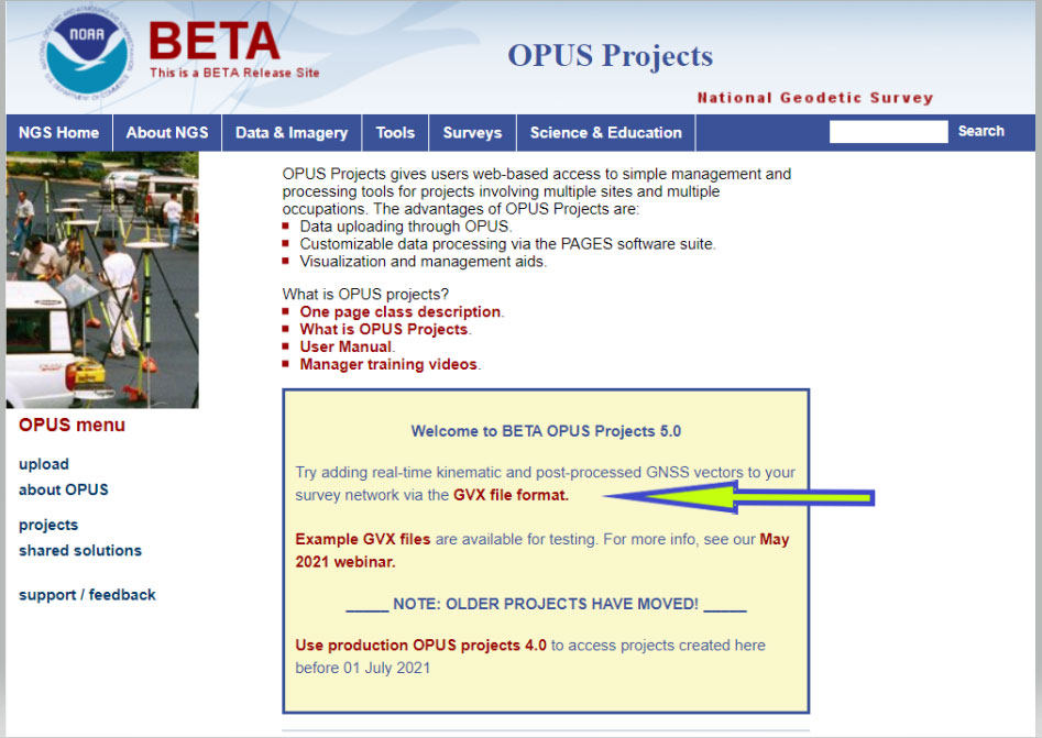
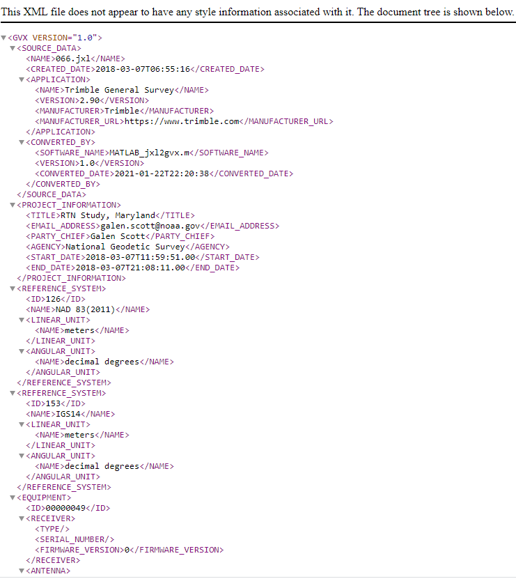
On Sept. 16, the National Geodetic Survey (NGS) released the latest beta version of OPUS, called Beta OPUS Projects 5.0. This version of OPUS now accepts real-time kinematic data and post-processed GNSS vectors from vendor software. See the box titled “Beta OPUS Projects 5.0 Webpage” on the website.
As stated in the announcement, NGS has developed a file format for submitted real-time kinematic (RTK) data and post-processed GNSS vectors from vendor software to NGS. It is denoted as GNSS Vector Exchange Format (GVX). This format enables NGS to incorporate the data into its GNSS processing routines.
This is similar to the original Receiver Independent Exchange Format (RINEX) developed for making post-processing more efficient when combining GNSS data from manufacturers outputting raw GPS data in varying file formats. In my opinion, this is a significant improvement to NGS’s OPUS web utility.
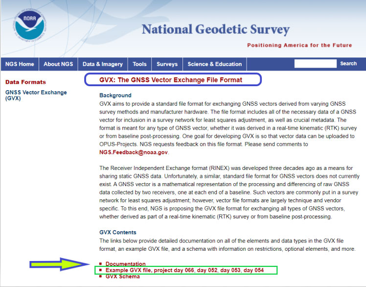
Users can obtain background information about the GVX file format by clicking the link GVX file format. More detailed information about the GVX format can be obtained by clicking on the Documentation link.
Basically, GVX is a standardized format for exchanging GNSS vectors derived from GNSS survey data using any manufacturer hardware and software results (see the box titled “Excerpt from Documentation of GVX”). NGS designed the format so that it included all of the necessary data (including metadata) of a GNSS vector for incorporation into a survey network for performing a least-squares adjustment.
To this end, this document proposes a new standardized file format known as the GNSS Vector Exchange Format (GVX). GVX aims to provide a standard format for exchanging GNSS vectors derived from varying GNSS survey methods and manufacturer hardware. The file format includes all of the necessary data of a GNSS vector for inclusion in a survey network for least squares adjustment, as well as metadata which describes the vector. The format is meant for any type of GNSS vector, whether it was derived in real-time or from baseline post-processing. GVX has been written in extensible markup language (XML). XML was chosen because it was designed to carry and store data in plain text format, it is easy to expand and/or upgrade to new operating systems, and it can be read by both humans and machines.
A sample GVX file can be obtained by clicking on the link titled “Example of GVX file, project day 066, day 052, day 053, day 054.” As NGS states in the documentation, the output can be read both by humans and machines. What’s important is that it can be read by machines so the information can be incorporated into software programs. GNSS vendors have all the information they need to generate the output file to enable users to import the data into OPUS Project 5.0. Users will have to contact their software providers to determine whether their software routines generate the GVX output files.
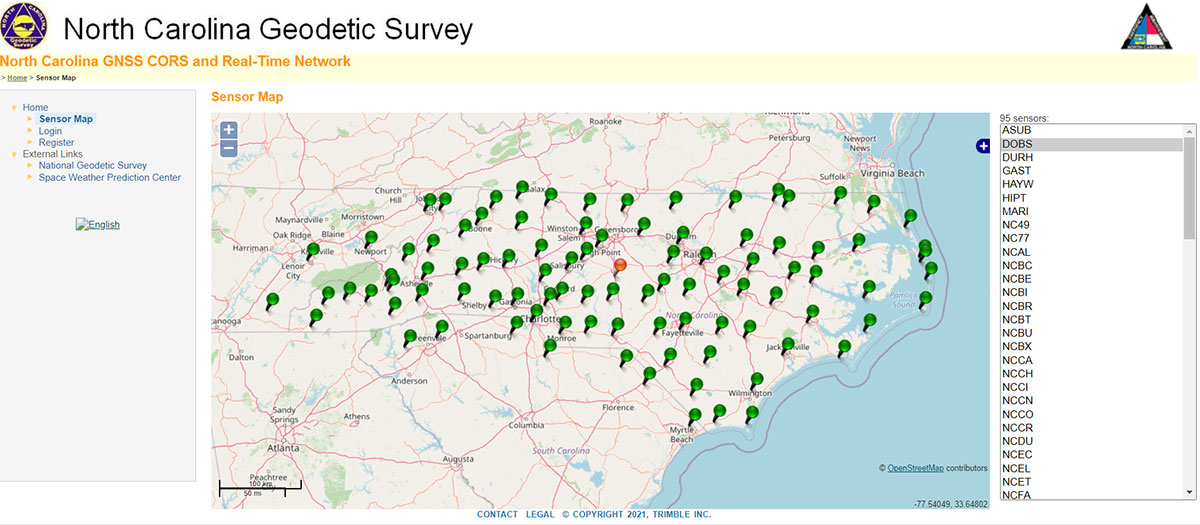
As I previously mentioned, this new option in OPUS Projects 5.0 is a significant improvement because many surveyors use RTK networks to obtain coordinates of marks. It will also facilitate the occupation of benchmarks with GNSS equipment to support the NGS 2022 Transformation tool. North Carolina, my home state, has a real-time network (RTN) that includes 96 GNSS CORS. (See the box titled “NC GNSS CORS and Real-Time Network.”) Currently, the North Carolina GNSS CORS and RTN has 4584 RTN service subscriptions.
I could not find a current list of public RTK networks in the United States, but I did locate a Jan. 7, 2014, GPS World article by Eric Gakstatter that provided a list of public RTK base stations in the country. It’s not up-to-date, but it highlights that, more than seven years ago, more than half of the U.S. states had some kind of public RTK network. I would like to update the table, so I’d appreciate receiving information on the status of any public RTK network. Please feel free to send me an email at [email protected].
California Real Time Network (CRTN) (single baseline). Plate Boundary Observatory. Single baseline.
Colorado
Mesa County (Trimble network) and Plate Boundary Observatory (single baseline).
Florida
Florida Department of Transportation. Leica network.
Idaho
Plate Boundary Observatory (single baseline).
Indiana
Indiana Department of Transportation. Leica network.
Iowa
Iowa Department of Transportation. Leica network.
Kentucky
Kentucky Transportation Cabinet. Trimble network.
Louisiana
Louisiana State University. Trimble network.
Maine
Maine Department of Transportation. Trimble network.
Massachusetts
Massachusetts Department of Transportation. Leica network.
Michigan
Michigan Department of Transportation. Leica network.
Minnesota
Department of Transportation. Trimble network.
Mississippi
University of Southern Mississippi. Trimble network.
Missouri
Missouri Department of Transportation. Trimble network.
Montana
Plate Boundary Observatory (single baseline).
Nevada
Washoe County. Trimble network. Las Vegas Valley Water District. Leica network. Plate Boundary Observatory (single baseline).
New Mexico
Plate Boundary Observatory (single baseline).
New York
New York Department of Transportation. Leica network.
North Carolina
N.C. Department of Environment and Natural Resources. Trimble network. $500 one-time sign-up fee.
Ohio
Ohio Department of Transportation. Trimble network.
Oregon
Oregon Department of Transportation. Leica network. Plate Boundary Observatory (single baseline).
South Carolina
South Carolina Geodetic Survey. Public but charges a usage fee. Trimble network.
Tennessee
Tennessee Department of Transportation. Public but charges a usage fee. Topcon network.
Texas
Texas Department of Transportation. Public but only available to TxDOT employees and TxDOT contractors. Trimble network.
Utah
Utah Automated Geographic Reference Center. Public but charges a usage fee. Trimble network. Plate Boundary Observatory (single baseline).
Vermont
Vermont Geodetic Survey. Trimble network.
Washington
Washington State Reference Network (Seattle Public Utilities). Trimble network. Public but charges a usage fee. Pierce County (Leica Network). Plate Boundary Observatory (single baseline).
West Virginia
West Virginia Department of Transportation. Trimble network.
Wisconsin
Wisconsin Department of Transportation. Trimble network.
Wyoming
Plate Boundary Observatory (single baseline).
Why do I believe that this new option in OPUS Projects 5.0 is so important? Because it facilitates the incorporation of accurate GNSS-derived ellipsoid and orthometric heights into the National Spatial Reference System (NSRS). With the development of improved algorithms, the results of coordinates computed using GNSS CORS/RTNs are more accurate today than ever before. During the last decade, there have been many studies analyzing GNSS data to estimate the accuracy values of coordinates from RTN data.
A study titled “Accuracy of GNSS Observations from Three Real-Time Networks in Maryland, USA” by Daniel Gillins, Jacob Heck, Galen Scott, Kevin Jordan and Ryan Hippenstiel presented at FIG Working Week 2019 in Hanoi, Vietnam, April 22–26, 2019, provided a comparative evaluation on the accuracy of three independent RTNs constructed with differing hardware and software. Their study was based on 486, 5-minute duration GPS + GLONASS network RTK (NRTK) observations. The results indicated that repeat NRTK vectors could be combined to meet 1 cm horizontally and 2 cm vertically (ellipsoid height) accuracies at 95%. confidence. See the box below. It should be noted that the repeat observations should be observed at different times of the day (for instance, separated by > 2–3 hours), as well as, in my opinion, if possible at least more than two different days.
A total of 486, 5-min duration, GPS+GLONASS NRTK observations were collected on nine bench marks distributed over a 4,000 square km area with rovers connected to three different RTNs in Maryland. Each RTN was developed with equipment and software from a different manufacturer, yet all three RTNs performed similarly in terms of accuracy. When differenced with coordinates from a static GNSS survey campaign, the horizontal and vertical RMSE of the NRTK-derived coordinates was 2.3 cm horizontally and 4.5 cm vertically at 95% confidence. Repetitive NRTK vectors on each baseline differed between ± 2.4 cm horizontally and ± 3.4 cm vertically at 95% confidence. As a final accuracy evaluation, hybrid survey networks consisting of repeat NRTK vectors and baseline solutions from post-processing static GPS data collected at RTN base stations and CORSs were adjusted by least squares. Prior to adjustment, the VCV matrices of the vectors were scaled by variance-component estimation. Adjustment of hybrid survey networks with four repeat NRTK vectors per bench mark produced network accuracies at 95% confidence for the adjusted coordinates at all bench marks less than 1 cm horizontally and 2 cm vertically (ellipsoid height).In addition to the benefits of using efficient and accurate NRTK vectors, the hybrid survey network approach makes use of redundant vectors for checking data and avoiding blunders. The approach also provides traceability because the NRTK vectors are tied to an RTN base station which is tied to CORS. Finally, these networks ensure the survey is referenced to the published coordinates of the CORSs which are held as constraints in the adjustment.
Lastly, I would like to remind users that only three months remain until the December 31, 2021, cutoff to submit GPS on Benchmarks data that NGS can guarantee will be analyzed to compute the initial set of 2020.0 Reference Epoch Coordinates (RECs) that will be released with the Modernized NSRS. This initial set of RECs is currently the only set that NGS can guarantee will be used to build the 2022 Transformation Tool. Once the transformation model is finalized, the NAVD 88 – NAPGD 2022 transformation values will be locked in and will not be updated as additional sets of RECs are computed. If you have questions or concerns about this cut-off date, please contact your NGS Regional Geodetic Advisor, or drop NGS a line at [email protected].
Beta OPUS Project 5.0 is a web-based tool that makes it easier to submit data to NGS. I would encourage NSRS users to occupy as many benchmarks with GNSS equipment and submit the data to NGS before the Dec. 31 deadline. Not only will these data help in improving the transformation model, but the marks will be included in the first computation of Reference Epoch Coordinates (RECs). You can obtain information about Reference Epoch Coordinates in NGS’s NOAA Technical Report NOS NGS 67 publication titled “Blueprint for the Modernized NSRS, Part 3: Working in the Modernized NSRS.” A future column will address the different types of coordinates that will be distributed by NGS with the modernized NSRS.
A roundup of recent products in the GNSS and inertial positioning industry from the October 2021 issue of GPS World magazine.
MOBILE
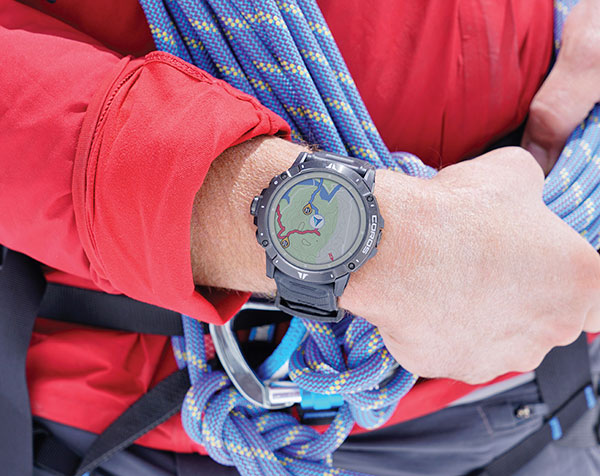
Smartwatch
Provides dual-frequency and topo maps
Photo: Coros
The Vertix 2 GPS “adventure watch” is equipped with a dual-frequency GNSS chipset for high accuracy. It communicates with all global navigation satellite systems simultaneously, and has a battery life of 140 hours while using GPS — otherwise, the battery extends to 60 days. Global offline maps include landscape, topography and hybrid views. The watch includes an Insta360 action camera and has 32 GB of internal storage.
AirFinder helps companies locate, monitor and manage business assets indoors and outdoors. The quickly deployable, massively scalable platform does not require an IT infrastructure or extra components or hardware. Rather than using an internal Wi-Fi system, AirFinder operates on Link Labs’ patented and secure Symphony Link network. Location data from each AirFinder device securely flows to the AirFinder web app or directly to customer databases via extensible APIs, which enable users to monitor assets in real time, analyze asset history, add rules and alerts, establish geofences and more.
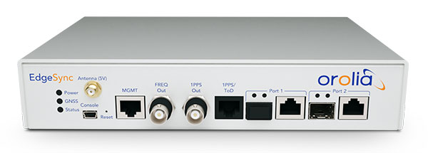
The EdgeSync network timing platform provides NTP and PTP grandmaster and boundary clock functionality for real-time edge applications. High performance, scalability, ease of use and manageability make EdgeSync suitable for data centers, finance, mobile edge computing, enterprise, smart grid, industrial IoT, process control and telecommunications. EdgeSync uses a multi-GNSS receiver (GPS, Galileo, GLONASS, BeiDou and QZSS), PTP and Synchronous Ethernet (SyncE) as input references and generates PTP, SyncE, NTP and timing signals (10 MHz, 1 PPS and time-of-day message) as outputs. It features dual 1-GbE ports for both copper RJ45 and optical network timing connections. EdgeSync also can provide IEEE 1588-2008 (PTP) grandmaster and boundary clock functionality.
CompassOne provides real-time military-grade location, orientation and direction sensing for deployed static and on-the-go assets. It receives all GNSS, ensuring uninterrupted operation. The device can be used both in counter UAV operations and general situations requiring satellite navigation. With a strong focus on durability and ruggedness, CompassOne is suitable for installation and operation in harsh environments. Military-grade connectors and high-end stainless-steel hardware ensure uninterrupted connection and protection from the elements, while the aluminum underside provides exceptional impact resistance and rigidity while keeping overall weight low. CompassOne can operate alone or be integrated with DroneShield’s DroneSentry system.
The Snapdragon 888+ 5G mobile platform is expected to power commercial smartphones from ASUS, Honor, Motorola, vivo and Xiaomi in the second half of this year. Satellite systems supported include all four constellations (GPS, BeiDou, Galileo, GLONASS) with dual-frequency GNSS. Additional systems supported include NavIC, QZSS and SBAS. Snapdragon 888+ provides AI-enhanced gameplay, streaming, photography and premium connectivity. Compared to its predecessor (the 888), Snapdragon 888+ provides an increased Qualcomm Kryo 680 CPU Prime core clock speed at up to 3.0 GHz and the sixth-generation Qualcomm AI engine with up to 32 TOPS AI performance, an improvement of more than 20%.
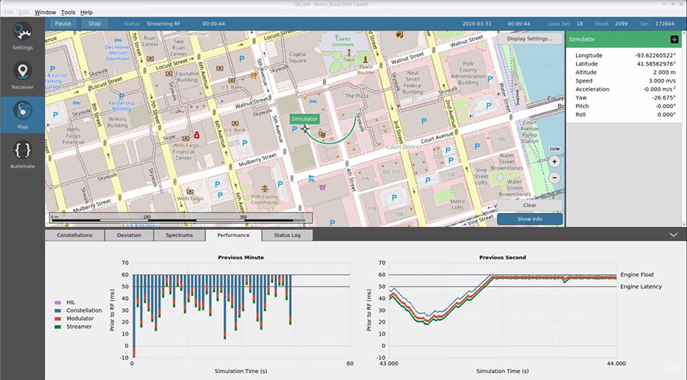
The Skydel Real-Time Performance graphs illustrate the software-defined engine’s low latency during a GNSS simulation. (Screenshot: Orolia)
A new real-time performance capability, now standard on all Skydel-powered GNSS simulators, achieves an ultra-low latency of 5 milliseconds. Skydel’s software-defined architecture is designed to meet the demanding GNSS simulation testing requirements in the automotive, military, space and other high-tech industries. Skydel also supports hardware-in-the-loop simulations without sacrificing ultra-low latency and high-end performance. A dashboard shows real-time performance graphs and enables users to grade the simulator’s performance, interpret data, diagnose inefficiencies, and optimize scenarios on the fly. As the system reaches its limits, it remains stable and fully operational, preserving the integrity of the simulation.
PointMan software is now integrated into the Vivax Metrotech vLoc3 with a GNSS real-time kinematic (RTK) receiver to create a utility-locate device. Using the RTK-Pro internal cellular module with 4G LTE capabilities, the operator can connect to the NTRIP RTK caster that provides RTCM 3 corrections. With the integration of PointMan with the vLoc3 RTK-Pro, critical buried infrastructure can be captured, recorded and displayed at survey-grade accuracy without additional external equipment or post-processing. The integration provides centimeter accuracy of the precise location of buried utilities in real time. Data collected includes the type of utility, the depth of cover and the utility’s precise location.
Geospatial and location intelligence for smart cities
Screenshot: Hexagon Geospatial
M.App Enterprise 2021 is a significant update to the platform for creating geospatial and location intelligence applications. The latest release features new browser-based 3D capabilities and enhanced visual effects, plus the ability to create and configure custom applications more easily. It allows users to access LuciadRIA’s 3D features with support for panoramic imagery, shading, ambient occlusion and other visualization effects to build browser-based solutions. It also features a new browser app configurator that makes it easier to create spatio-temporal dashboards, or Smart M.Apps. Feature Analyzer now allows users to add and manage multiple datasets on the fly and set up workflows.
Single-base RTK is an excellent choice for many uses but mixing different baseline lengths can yield inconsistent results
By Gavin Schrock, PLS
Gavin Schrock, PLS
The surveying lead for a construction firm started getting calls from his crews — suddenly they were not checking in to existing control with the accuracy required. This presented a conundrum and an immediate resolution was needed to stay on schedule. What had changed? A nearby permanent base, part of the regional real-time GNSS network (RTN), had suddenly gone dark, and when the crews switched to other bases, they got the inconsistent results. Time to call the RTN. (See a primer on RTN.)
I have been operating a regional cooperative RTN for 19 years, and I get these kinds of support calls regularly, but typically only from users of the single-base mountpoints. Most RTN provide, via NTRIP casters, both network RTK (NRTK) solutions — such as master-auxiliary, VRS and FKP — and single-base solutions for each base. The base they had been using was down while the roof of the city building on which it is mounted was undergoing some maintenance.
The construction firm, halfway through a multi-year transportation project, had used the base when they established project control, and for layout and as-built tasks. Using the base, which was slightly more than 4 km from the site, the crews were used to seeing check-in results of 0.3′ (9 mm) or better (horizontal). When they switched to different bases, 23 km and 25 km distant, the results were now inconsistent, and in many instances, double.
This was an easy fix. We met on site and checked results using the network solution; it closely matched the results they were seeing from the original base. Until the original base was restored, this would meet their needs.
It made a lot of sense to use the nearby base, as setting a temporary project base on the congested and sky-view challenged site was impractical. Furthermore, the baseline length of 4 km yields excellent results. Single-base RTK is a powerful tool, and a default for many construction projects, provided that:
the base has an unobstructed view of the sky
the base is free of nearby multi-path hazards
the base receiver and the antenna are of the same or better quality as the rovers
the base receiver and the antenna support the constellations and the signals desired.
In many ways, it is hard to beat single-base RTK. For instance, if you set up a base right on the site, say less than a kilometer away, this should yield the best results possible for RTK, and can be better than network RTK.
However, there are challenges. Single-base, typically “iono-free” solutions common in today’s rovers, degrades over the baseline length. The rule of thumb for many is that the degradation becomes noticeable when baseline lengths exceed 10 km. It is not uncommon for rovers to fix at much longer baseline lengths; 20 km, 30 km, 50 km or more — but results will likely vary from hour to hour or day to day. Changes in ionospheric and tropospheric conditions can bring inconsistencies, particularly over longer baseline lengths.
Network RTK may not beat single-base over very short baselines, but as it uses 5 to 15 bases (depending on the implementation) it can better model in the varied conditions. It can provide great consistency and repeatability, even if an individual base is unavailable, as was the case for this conduction site. There are strengths and weaknesses for both. NRTK brings consistency over a wide area, you do not have to set up (and guard) your own base, and the geodetic values are solved.
If you can have an on-site base, you can under certain conditions see a gain in results. This is especially important for certain applications, such as machine control and precision agriculture, for which tight year-to-year and row-to-row repeatability is key. However, if you may need to use another base at some point, you may be better off starting with NRTK, if it yields the results you seek.
Gavin Schrock is a practicing surveyor, technology writer, editor of xyHt Magazine and operator of a cooperative GNSS network.
Applanix, a Trimble Company, has introduced new term licenses with full maintenance and support for its desktop post-processing software — POSPac Mobile Mapping Suite (POSPac MMS) and POSPac Unmanned Aerial Vehicles (POSPac UAV).
In addition, a new subscription for POSPac PP-RTX for UAV is also available.
The new licensing options lower the upfront investments required and enable customers to always have the newest features with updates included as part of the bundled maintenance and support.
The announcement was made at Intergeo 2021, a conference on geodesy, geoinformatics and land management, which took place this week in Hannover, Germany.
“The new licensing options for POSPac MMS and POSPac UAV provide our customers with maximum flexibility for acquiring full access to our industry-leading post-processing solutions. The options offer lower upfront initial investments and provide customers with full access to future releases and 24/7 customer support, as part of the included maintenance in the license agreements,” said Joe Hutton, Applanix’s Director of Inertial Technology and Airborne Products.
The new POSPac PP-RTX for UAV subscription is available with varying term lengths to accommodate user requirements. POSPac PP-RTX enables quick and easy data processing without a base station. The correction data is available within minutes after mission completion and requires a single button click in POSPac to launch. Customers will be able to process up to 30 minutes of dynamic data from the UAV platform.
The new licensing options and subscriptions are available now through the Applanix global sales channels.
A roundup of recent products in the GNSS and inertial positioning industry from the September 2021 issue of GPS World magazine.
OEM
Network Expansion
Provides precision timing over fiber
Photo: Huber+Suhner
Direct GPS-over-Fiber is a copper-free GNSS remote antenna that eliminates the need for costly power infrastructure. It uses power-over-fiber technology to distribute both the timing signal and power for the remote device. It is designed for telecommunication and data-center customers in need of scalable timing infrastructure solutions for outdoor remote antenna applications. It is fast and easy to install, with flexible, space-saving configurations that eliminate the need for power infrastructure at the remote end. The product makes network expansion achievable with a compact design and integrated transmitters, eliminating the need for multiple GPS antennas and maximizing the available space. It also extends the signal range between the antenna and the receiver.
The cost-effective EdgeSync network timing platform provides NTP and PTP grandmaster and boundary clock functionality for real-time edge applications. High performance, scalability, ease of use and manageability make EdgeSync suitable for data centers, finance, mobile edge computing, enterprise, smart grid, industrial IoT, process control and telecommunications. EdgeSync uses a multi-GNSS receiver (GPS, Galileo, GLONASS, BeiDou and QZSS), PTP and Synchronous Ethernet as input references and generates PTP, SyncE, NTP and timing signals (10 MHz, 1 PPS and Time of Day message) as outputs. It also can provide IEEE 1588-2008 (PTP) grandmaster and boundary clock functionality and leverages unique PTP algorithms to deliver stringent timing for demanding, precise applications.
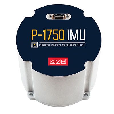
The P-1750 IMU and the P-1725 IMU complement the previously released P-1775 IMU to create a full line of IMUs with high-performance accelerometers and photonic integrated chip (PIC) technology. The P-series IMUs are offered in the same compact IMU housing design, and now offer more dynamic and accurate sensor performance, delivering improved navigation capability and more environmental robustness in vibration and shock capability for more challenging applications. PIC technology features an integrated planar optical chip that replaces individual fiber-optic components to simplify production and increase reliability. The accelerometers used in the P-series IMUs offer greater sensitivity and accuracy in their dynamic ranges. The IMUs are designed for challenging applications on land, sea and air, including autonomous trucks and people movers, drones, autonomous underwater vehicles and platform stabilization. Industries include transportation, military, agriculture, construction and mining.
The HC860 and HC860E active GNSS/Iridium antennas are designed for precise positioning, covering the GPS/QZSS-L1/L2, GLONASS-G1/G2, Galileo-E1 and BeiDou-B1 bands, including regional SBAS. The antennas also support active Iridium reception in the 1616.0-1626.5 MHz band. The HC860 housed and HC860E embedded helical antennas are designed for high-accuracy positioning. They are packaged in a light, compact form factor suitable for a variety of applications, including autonomous vehicle navigation (land, sea and air), handheld survey devices, automotive positioning, timing and other precise-positioning applications.
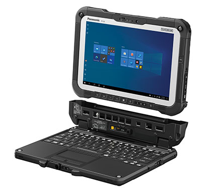
The Panasonic Toughbook G2 is a fully rugged 2-in-1 detachable tablet with optional keyboard that features an innovative modular design and user-removable expansion packs (xPAKs). With three modular expansion areas and up to 36 xPAK combinations, users can customize the Toughbook G2 to suit their needs with options including a 4G LTE-A multi-carrier with GPS or a dedicated U-blox NEO M8N receiver. The device is backward compatible with most Toughbook 20 and G1 docks. It has a 10.1-inch display, an Intel Core i5 and i7 vPro processor and runs on Windows 10 Pro. It has an 18.5-hour battery life. The 2-in-1 detachable design allows users to operate the device both in laptop and tablet modes.
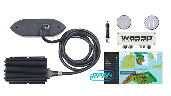
The WASSP S3r multibeam sounder combines data from a multibeam sounder transducer with 224 beams covering a 120° swath port to starboard along with position, heading and motion to create an accurate survey situations and environmental conditions. WASSP S3r is able to survey areas up to 10 times faster than a single-beam sounder. The S3r uses an SBG Ellipse-D Inertial Navigation System for its RTK + INS. The Ellipse-D allows the sounder to create accurately positioned 3D bathymetric representations of the seafloor, down to centimeter accuracy with minimal passes. WASSP has also incorporated the Ellipse-D into its S3Pr portable survey package. The SBG Ellipse-D was able to fit into a covered housing that allows quick setup on small vessels and interface with the WASSP DRX processing unit and CDX software. Ellipse-D integrates a dual-antenna, multi-band GNSS receiver, and is capable of delivering precise heading as well as centimeter-level position accuracy in challenging GNSS conditions.
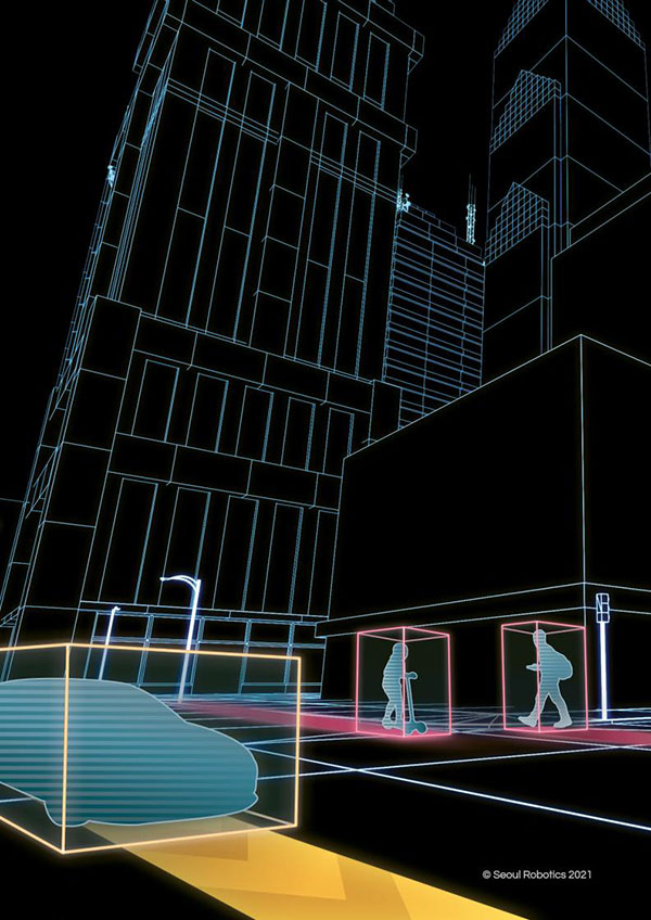
Voyage is a plug-and-play lidar perception system that delivers highly accurate object detection, tracking and classification capabilities. The deployment kit is equipped with SENSR2 software, lidar sensors and a lidar processing unit. Voyage provides volumetric profiling and motion-prediction capabilities, regardless of lighting conditions, and can collect and process data from up to four sensors for insights across the sensor coverage zones. Voyage does not capture, show or store any biometric and otherwise identifying data to maximize the protection of people’s privacy when installed as part of smart-city and security systems. The company’s sensor-agnostic perception software is available worldwide and is deployed by top-tier organizations such as BMW, Mercedes-Benz, the Chattanooga Department of Transportation and Emart, among others.
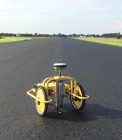
The TinySurveyor is a high-precision instrument for the surveying and infrastructure industries, able to execute large tasks up to 10 times faster than traditional methods. The machine pairs with a GNSS receiver to accomplish large-scale stake-outs, road pre-marking, as-built surveys and topographic surveys. Its ability to mark out existing data or collect new data at high speed and with high accuracy makes the TinySurveyor suitable for repetitive, time-consuming and labor-intensive tasks. With a GNSS receiver, repeatable results ensure accuracy of 1-2 cm. The TinySurveyor integrates with any GNSS receiver and has been tested with units from Topcon, Trimble and Leica.
Maptitude for Redistricting 2021 is a specialized tool for political redistricting that enables state legislatures, political and public interest groups, local governments and private citizens to create and advocate redistricting plans that meet their goals, adhere to legal requirements, and stand up to public scrutiny and legal challenges. Unlike a general-purpose GIS, Maptitude for Redistricting streamlines the plan creation process for all types of political boundary definitions and provides all of the calculations and reports needed. It is suitable for congressional redistricting as well as state legislative districts, city councils and local school board districts.
With the Luciad 2021 platform, defense, aviation, maritime and other organizations can develop effective and reliable web applications. LuciadFusion, an all-in-one server solution for geospatial data management, has two new types of data streaming, resulting in faster streaming of imagery and point cloud data. LuciadRIA supports Web Assembly to bring desktop-like calculations to the browser. Luciad 2021 also features enhancements to software development kits for desktop and on-board vehicle applications. LuciadLightspeed seamlessly integrates into JavaFX-based applications, making it easier to embed its map components into user interfaces, and now provides for high-resolution map printing. LuciadCPillar, an API for C++ and C# developers, was updated with labeling support and other new features.
The Ping200XR integrates the capability of the Ping200X TSO Certified Mode S ADS-B OUT transponder with the high-integrity truFYX TSO-certified GPS position source into a single enclosure. The integration simplifies installation and allows the customer to choose between the installed GPS antenna or one provided with the Ping200XR. The integrated GPS ensures maximum safety by providing Source Integrity Level (SIL) 3 RTCA DO-229D and TSO-C145e Class Beta 1 performance, a requirement for Mode S and ADS-B airspace access, and for reception and processing by certified avionics and traffic collision avoidance systems in other aircraft as well as air traffic control. SIL 3 performance is not available from non-aviation certified GPS receivers, which often are used as an autopilot navigation source.
The RTL-450 lidar sensor incorporates a lightweight MEMS mirror and a precision navigation system to generate accurate data for demanding aerial surveying missions. The high-resolution, three-dimensional point clouds it creates enables operators to conduct advanced analytics of geographic and manmade features. Made in the United States, the RTL-450 incorporates patented lidar sensor technology. It weighs just over 4 pounds and is designed to operate independently of a drone platform, providing great flexibility for drone integration. Its modular design facilitates quick, efficient integration onto user-selected platforms.
The RIEGL VUX-240 is a lightweight airborne laser scanner, especially designed for use on UAS/UAV/RPAS and small manned airplanes or helicopters. With its wide field of view of 75° and a data acquisition rate of up to 1.8 MHz, the instrument is suitable for high-point-density corridor mapping applications. The VUX-240 uses Riegl’s Waveform-Lidar technology, allowing echo digitization and online waveform processing. Multi-target resolution is the basis for penetrating even dense foliage. A continuously rotating polygon mirror wheel enables scan speeds of up to 400 lines per second, for efficiently covering large areas when operated from fast UAVs or aircrafts. The scanner stores 1 terabyte of data internally and is equipped with interfaces for an external IMU/GNSS system to control up to four external cameras.
The Carrier H6 Hybrid is a heavy-lift gas-electric hybrid drone powered by either the H2400 (Carrier H6 HE+) or H5000 (Carrier H6 HL) hybrid drone generator. The Carrier H6 Hybrid HE+ is equipped with the H2400 generator providing 2400W of continuous power. The recommended payload is 4 kg allowing for up to 2.5 hours of flight. The maximum payload of 6 kg allows up to 1.5 hours of flight. The Carrier H6 Hybrid HL has a maximum payload capacity of 15 kg and can be configured to carry more robust scientific-grade sensors, such as multispectral cameras, professional DSLRs for cinematography and lidar. The H6 Hybrid HL also can be used in heavy-lift applications involving asset transportation and delivery, agricultural spraying and search and rescue.
Harris Aerial, harrisaerial.com
Industrial drone system
Autonomous ops from a dock
Photo: PowerVision
The PowerVision True Unmanned Aerial System combines the PowerEgg X 8K drone, PowerEgg Dock and the PowerVision Cloud web-based software platform. The integration provides a turnkey solution for remote, autonomous data-collection missions. With the system, drones can be deployed at scale as data-acquisition infrastructure, instead of tools to be operated on individual missions. Powered by artificial intelligence, the system streamlines the drone’s takeoff, flight, dynamic mission and return to the charging dock autonomously. The system weighs 34.8 pounds (15.8 kg) in a 570 x 400 x 250-millimeter form factor, allowing it to be deployed by a single person without special tools or equipment. The solution can be used for powerline inspections, environmental compliance, asset inspection, facility security, GIS, surveying and mapping.
The StarCourse service provides real-time extended ephemeris data for GNSS chipsets in connected mobile devices, giving them a headstart in determining position accurately and quickly. For devices with limited connectivity, typical extended ephemeris solutions have provided a headstart with 7¬–14 days of ephemeris data. StarCourse provides a 50% reduction in RAM requirements, 90% reduction in CPU cycles, and high location accuracy. Full data customization is provided to StarCourse subscribers, allowing them to create optimal solutions for their needs. The service enables autonomous positioning on connected GNSS IoT devices including asset tracking, wearables, in-dash navigation and mobile devices. For situations where accuracy is paramount, StarCourse Premium provides ultra-precise predicted ephemeris for the first 24 hours.
Trailer management solution FleetLocate captures data at the trailer level and translates it into actionable business intelligence to increase trailer productivity while reducing waste and costs. Telematics devices deliver core trailer insights that help automate yard checks and maximize use. Advanced trailer technologies are available, such as solar power management, tethered/untethered configurations, IntelliScan cargo sensing, cargo image capture and retrieval, door sensors, liftgate battery monitoring and more.