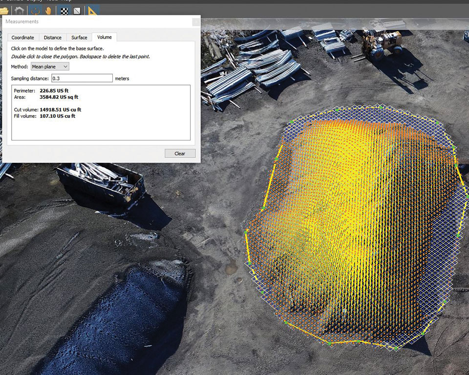
The West Virginia Department of Transportation (WVDOT) turned to UAVs to save time and money. Incorporating drones has saved WVDOT more than $340,000 in a single month.
In 2017, WVDOT began formally looking into launching a drone program. WVDOT concluded that drones could be ideal for stockpile surveys — using them had the potential to speed up the process, reduce risk, and increase accuracy.
Jesse Bennett, statewide survey unit leader at WVDOT, flew several test missions to validate the use case. He quickly realized drones had huge potential to transform this time-consuming and risky task.
The agency began with a team of nine Federal Aviation Administration-certified drone pilots and 12 drones. WVDOT also began using Skyward’s Drone Management Platform to manage their flights, pilots and equipment. Skyward offered a single, digital platform to coordinate complex missions and obtain airspace permissions.
“I saw the need for something like Skyward from the very beginning, when I was the first and only pilot,” Bennett said. “I was manually making entries in flight logs and maintenance logs, and I was using about seven or eight different apps and websites just to plan and fly a mission.”
Using Skyward as a single place to keep track of every aspect of the drone program enabled Bennett to quickly resolve an investigation after someone mistakenly assumed he didn’t have authorization to fly in an area and reported him to the FAA.The software helped him demonstrate that crews were obeying FAA regulations and WVDOT’s own rules.
Starting in spring 2019, WVDOT began deploying drone crews for stockpile inspections at scale. WVDOT has 177 sites across the state that contain stockpiled materials. Each year, the stockpiles must be physically surveyed to calculate the volume of material. From 42 surveyors laboring for 15 workdays, the same workload took seven UAS pilots only nine workdays to complete the project.
A roundup of recent products in the GNSS and inertial positioning industry from the April 2021 issue of GPS World magazine.
OEM
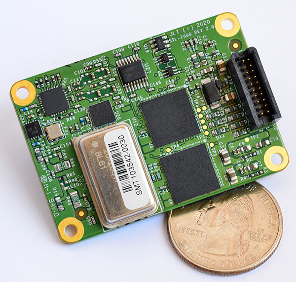
STL receiver
For Satellite Timing and Location service
Photo: JLT
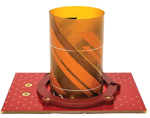
The STL-2600 Satellite Timing and Location (STL) commercial receiver was designed in partnership with Satelles Inc., the STL service provider. The STL-2600 provides a GNSS-independent, low-cost capability to generate UTC nanosecond timing and meters-accurate positioning anywhere in the world. The STL signal has 30-db (1,000 times) higher power compared to GPS signals, allowing the receiver to operate deep indoors independent of any GPS/GNSS signal. It is also useful in marine applications where GNSS signals are regularly denied or manipulated and for stationary high-accuracy timing applications such as 5G. It can be directly connected to JLT’s GPS Transcoder products for glueless retrofit capability of existing customer legacy GPS-only receiver systems to Galileo, GLONASS, BeiDou, QZSS and SBAS as well as adding the STL and optional atomic holdover capability to these legacy systems.
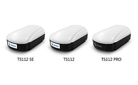
The TS112 family of smart antennas is designed for demanding applications such as agricultural machine autosteering systems that require high positioning accuracy. They offer scalable positioning solutions with increased GNSS availability, reliability and accuracy. Each of the three models embeds Harxon X-Survey four-in-one technology. The high-gain and wide beamwidth multi-constellation GNSS antennas integrate 4G, Bluetooth and Wi-Fi in a compact unit. They feature multi-point feeding technology, ensuring high phase-center stability and real-time kinematic (RTK) centimeter-level positioning accuracy. They integrate a high-precision GNSS module with multi-band GNSS receiver and Harxon’s four-in-one multifunctional GNSS antenna in a compact housing.
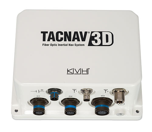
The TACNAV 3D tactical navigation system is now available with the P-1775 inertial measurement unit (IMU) featuring KVH’s new photonic integrated chip (PIC) technology. PIC technology features an integrated planar optical chip that replaces individual fiber-optic components to simplify production while maintaining or improving accuracy and performance. KVH’s IMUs with PIC technology are designed to deliver improved bias stability and greater accuracy. The fiber-optic gyro (FOG)-based TACNAV 3D tactical navigation system provides an assured positioning, navigation and timing (A-PNT) solution with an embedded GNSS and optional chip-scale atomic clock (CSAC).
IoTeX has selected Nordic Semiconductor’s nRF9160 low-power System-in-Package (SiP) with integrated LTE-M/NB-IoT modem and GPS receiver to provide the cellular internet of things (IoT) connectivity for its Pebble Tracker. The Pebble Tracker provides trusted location, environment and motion-tracking data for global asset tracking and industrial supply chain applications. Critical features strengthen security from hacking and data corruption, meeting the demand of applications that require strong data security and integrity protection throughout the supply chain. There are two versions of Pebble Tracker. The first targets blockchain and IoT developers, while a second commercial version is designed for the asset tracking and industrial supply chain markets. The product combines an environmental sensor, a motion sensor (gyroscope and accelerometer), and an ambient light sensor. It enables cellular network connectivity and integrated GPS support in a global version supporting precise, long-range tracking of asset data using established cellular infrastructure.
Enables transmission of corrections via the internet
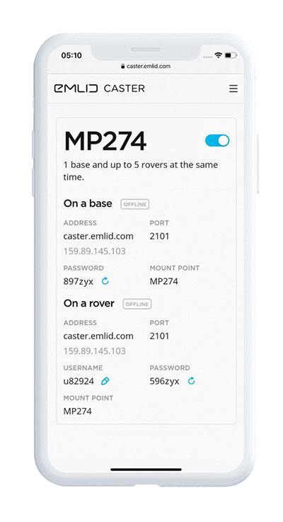
Emlid Caster is an easy way to transmit corrections between real-time kinematic (RTK)-capable devices via the internet. Emlid Caster has a simple interface. Users can create their personal mount point and connect one base and up to five rovers. It works not only with Emlid products but any other device supporting NTRIP. For example, users can pass RTK corrections to the DJI Phantom 4 RTK drone from the Reach RS2 receiver as a base station. Emlid Caster is free and available worldwide. Once signed up, personal NTRIP credentials are generated automatically for a base and a rover.
The Trimble Siteworks SE Starter Edition. (Screenshot: Trimble)
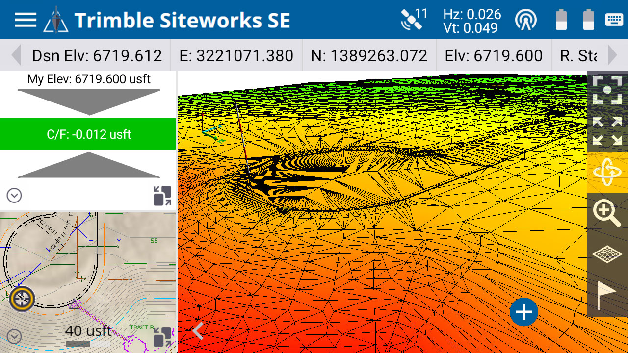
The Trimble Siteworks SE Starter Edition is an entry-level construction surveying software program. With the program and a construction GNSS receiver, a supervisor, foreman, grade checker or site engineer can easily check a grade, slope or alignment and navigate the project more accurately and in less time than with traditional survey methods. It also can give more personnel on the jobsite access to survey technology, enabling more productive and efficient field crews. Trimble Siteworks SE Software is a simplified version of Trimble Siteworks Software, intended for users who do not require a full feature set and are interested in a lower-cost version to connect to GNSS only. Contractors can easily upgrade to the full version.
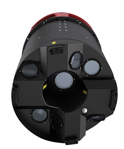
The Leica CityMapper-2L configuration is designed for airborne urban mapping projects at low altitude operation. Lower flying heights can be required by air traffic control (ATC) restrictions and in areas with low cloud cover. It features a 71-mm focal length at nadir, suitable for 5-cm ground sample distance (GSD) data acquisition at flying heights of 940-m above ground level. The new lenses offer similar coverage and productivity for a specific GSD as existing configurations for standard and high-flying heights, while significantly expanding the operation envelope. The CityMapper-2 hybrid airborne sensor combines oblique imaging and a lidar in one system. The sensor efficiently creates digital twins of cities. The system includes two 150 MP nadir cameras (RGB and NIR), four 150 MP oblique cameras and a 2-MHz linear-mode lidar sensor.
Full-waveform flash data for autonomous vehicle development
Photo: LeddarTech
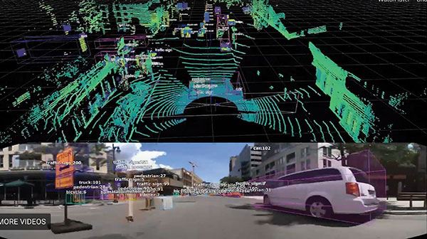
Leddar PixSet is a publicly available sensor dataset for advanced driver assistance and autonomous driving research and development. The dataset includes full-waveform data from LeddarTech’s Leddar Pixell, a 3D solid-state flash lidar sensor. LeddarTech is offering these datasets free of charge for academic and research purposes. It allows academic and engineering research teams specializing in advanced driver-assistance systems (ADAS) and autonomous driving technology to use existing sets of sensor data to test and develop advanced software and to run simulations without having to assemble new sensor suites and collect their own dataset. An instrumented vehicle was utilized in the development of the dataset. The various scenes were recorded in high-density urban and suburban environments as well as on the highway.
The mdLiDAR1000HR aaS drone lidar survey package is designed for professionals responsible for geospatial data collection, such as corridor mapping, mining (volume calculation), construction site monitoring, recording environmental changes over time, forestry, contour mapping, archaeology and cultural heritage, and more. The drone lidar system has a 90° field of view for both scanned points and imagery. It repeatedly provides a precision of 1.6 cm (.052 feet) when flown at 40 m (130 ft) at a speed of 8 m/s (18 mph). It integrates the Velodyne Puck Lite lidar sensor.
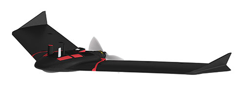
The fixed-wing eBee Ag drone can provide a complete assessment of a farm and crops faster than traditional field scouting. With its dual-purpose Duet M camera, eBee Ag captures accurate RGB and multispectral data that enable farmers to effectively assess crop health and help catch early indicators of pests, diseases and weed infestations that threaten crop yields. It features real-time kinematic (RTK) functionality for greater mapping precision. With its available RTK, the drone can achieve absolute accuracy down to 2.5 cm (1.0 inches) with RGB. Highly accurate index maps allow farmers to understand each acre while managing problematic areas field-wide.
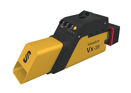
The Vx15-300 and Vx20-300 UAV lidar solutions are new additions to Yellowscan’s Vx product series. A new terrain software module allows users to automatically classify grounds from off-ground, as well as export various digital elevation models. Both integrate the Riegl Mini-VUX 3 airborne laser scanner (1.55 kg / 3.4 lbs), designed specifically for integration with UAVs. The scanner offers a selectable 100-kHz, 200-kHz and 300-kHz laser-pulse repetition rate (PRR). At 300-kHz PRR, the sensor provides up to 100,000 measurements per second at 120° field of view, and thus a dense point pattern on the ground for UAV-based applications that require the acquisition of small objects.
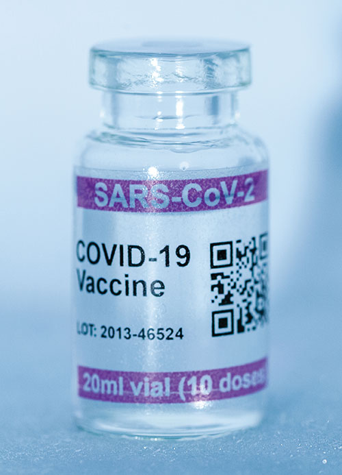
Cryo-Vacc containers use helium — a fraction of the weight of nitrogen — to provide safe transportation of vaccines at the required extremely low temperatures and for periods of up to 30 days, without the need for any power supply. Now in prototype, the containers work with both air and ground transportation. A temperature range of -150°C to 8°C, makes it versatile for a range of vaccines — including those for COVID-19 — that need to be transported for up to 25 days or longer in transit, where access to an external power source is not possible. Combined with cold-chain monitoring and asset tracking technology from Beyond Wireless (a World Health Organization-certified provider), Cryo-Vacc can provide accurate temperature readings of vaccines in transit, as well as GPS-based tracking to ensure the custody chain can be audited.
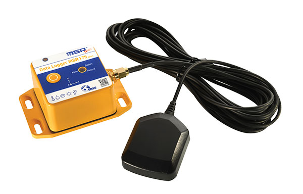
The tamper-proof MSR175plus GPS data logger records potentially damaging shock events as well as the associated ambient conditions with the exact geographic position via its GPS/GNSS receiver. It contains two 3-axis-acceleration sensors (±15 g/±200 g), a temperature sensor (-20 to +65° C), a humidity sensor (0 to 100% relative humidity), air pressure sensing (0 to 2000 mbar), and an ambient light sensor (0 to 65,000 lux). It helps ensure compliance with transport specifications and provides irrefutable data for identifying damage liability for help with insurance claims. An external connector is ready for a cable-connected antenna. The removable, rechargeable 2400 mAh LiPo-battery enables recording for up to 8 weeks (at least one year without GPS-based tracking).
The worlds of UAVs, lidar and surveying overlap, with UAV-based lidar able to shed light on places that are difficult or dangerous to access by other means.
Two questions come into play when deciding whether to use UAV-based lidar for a surveying project. First, do you use a UAV or a manned aircraft? The answer concerns cost, safety and efficiency.
Second, do you use only photogrammetry or photogrammetry plus lidar? This answer depends not only on cost, but payload weight — the single biggest constraint with UAVs. Lidar scanners weigh considerably more than comparable digital cameras.
Far from being mutually exclusive, photogrammetry and lidar are complementary, because digital images make it possible to colorize lidar point clouds, making them easier to interpret. However, the less a UAV’s payload weighs, the greater its flight time per battery charge.
“Most surveyors do not want to be UAV pilots. They want to do their job faster and easier,” said Jake McCay, director of business development at Lidar USA. His company manufactures laser systems — integrated with IMUs and software — for backpack systems, UAVs and helicopters. UAVs make surveyors much more productive and yield more accurate data because they enable them to collect many more points, he said.
UAV versus manned aircraft
Traditionally, data for corridor mapping — such as for power lines and railroads — has been captured with helicopters. However, cost and safety considerations have increasingly shifted the balance toward UAVs, especially hybrid systems that can take off vertically then transition to horizontal flight.
UAVs are also able to fly much lower than manned helicopters, thereby capturing data at much greater resolution.
Nevertheless, manned aircraft still have advantages. “Typically, the break-even is somewhere between 20 km and 40 km on a corridor mapping project if you consider a multi-rotor setup,” said Philipp Amon, business division manager, ULS, Riegl Laser Measurement Systems GmbH. “It takes a week of data acquisition using a UAV and two staff out in the field for what you can normally collect in half a day using a manned aircraft. The costs are almost the same.”
Beyond-visual-line-of-sight (BVLOS) flights are challenging for UAV pilots, because it makes them nervous to lose sight of their expensive platform. Successful BVLOS flights require a dependable and redundant data link. High-quality video transmissions that allow operators to monitor their UAV’s behavior in real time and with no significant latency are also very helpful. “If you do not have all these systems in place, I would not risk it either,” Amon said.
Whether mapping a corridor with a UAV or a manned helicopter, it is best to fly in one direction to the side of the corridor, then return on the other side, capturing data at an oblique angle rather than at nadir. This doubles the point density, enables the correction of any shadows created in a single flight, and — in the case of power lines — enhances safety.
Manned operations require a team of four and a helicopter, as well and a much greater focus on safety than UAVs, said John “JP” Cannon. Cannon is a UAV pilot for PrecisionHawk and team lead of the company’s lidar flight operations, totaling five pilots and more than 10 lidar sensors.
With a manned aerial survey, “You are a little more efficient, but you are burning a lot more logistics to get to that point,” he said. With a UAV, “if you have a properly calibrated sensor and a well-trained pilot, you can get even better data because you can fly lower and slower.” A manned helicopter would require multiple passes to get the same quality of data.
UAVs can collect data even in very remote locations, for later post-processing. (Photo: Lidar USA)
Lidar and photogrammetry
“We combine our lidar systems with all kinds of photogrammetry solutions, such as standard RGB cameras, in both nadir and oblique mounting options,” Amon said. “We also have multi-spectral cameras, hyperspectral cameras, and thermal-imaging sensors in our portfolio, and we offer fully integrated systems that combine all these sensors into one system.”
His customers prefer to use lidar sensors, especially to penetrate vegetation, Amon said. “That is often the most critical part of a survey, especially if you have dense vegetation and are looking for small objects, like in a powerline survey.” While a laser scanner’s multiple returns make it possible to extract surfaces even under vegetation, photogrammetry excels for spot detection.
“If you really want to nail down the error at a specific point, you will need to look at the photogrammetry data. If you want to do surface extraction, classification and remove vegetation, then you are looking for lidar.”
It is generally much faster to post-process lidar data because it does not require georeferencing and correcting thousands of images, but extracting and classifying features takes about the same amount of time.
Lidar “enables utility industry leaders to more effectively manage their networks,” said Cannon. It gives them “a visibility of their assets that photogrammetry just cannot provide, with more robust, precise and consistent data sets.”
Lidar data, he argued, is also less labor-intensive than photogrammetry, because the latter requires constantly tweaking camera features to deal with changes in the environment, such as the amount of light, whereas a well-calibrated lidar scanner “always performs.”
After having tried numerous lidar scanners over the years, PrecisionHawk chose the Riegl miniVUX-1DL, a downward-looking version that can shoot 23˚ off nadir, forward, center and rear. “We use it 20 times a day across multiple platforms.,” Cannon said. “Its data output is consistent and reliable.”
Dissenting voice
A dissenting voice is that of Wingtra, a manufacturer of vertical take-off and landing UAVs for mapping, survey and mining industry professionals, which has decided not to pursue UAV-based lidar for surveying. “We looked at different use cases, which sensor makes sense for each one, what is already there, and what can be done with manned aircraft and photogrammetry,” explained Andrea Nater, the company’s customer success manager.
“We found that the space for UAV-based lidar systems is very small. There are claims about very high accuracy, but we have not seen that. The point density we have seen so far is limited to 10-cm spacing, so you are really limited in an accurate and dense point cloud, whereas you can have a much higher resolution with photogrammetry.”
While the platform’s absolute position is independent of whether it carries a digital camera or a lidar sensor, “if you have fewer points on the ground, you also have less accuracy,” Nater said. For large areas, UAV-based lidar cannot compete with manned aircraft carrying expensive systems, she said.
“We have also compared manned aircraft with a UAV with low-cost lidar and an RX1 camera. For most use cases you are better off with a high-quality camera rather than a ‘low cost’ lidar. Despite the lidar being more expensive than the camera, the final outputs (point cloud or 3D mesh) generated by photogrammetry have a lower noise level and a higher point density.”
As a bonus, there are more tools for photogrammetry. “The workflows with the many photogrammetry companies are very simple to use, whereas for lidar it is still not as well established and easily adoptable by everyone as it claims to be,” Nater said.
Wingtra’s UAVs perform vertical take off and landing (VTOL), but fly horizontally. New European regulations easing restrictions on flight beyond visual line of sight (BVLOS) make this increasingly common. (Photo: Wingtra)
Positional accuracy
Achieving high positional accuracy with a UAV is challenging, due to the platform’s weight and size limitations for GNSS receivers and antennas. For dedicated UAV missions, Riegl uses the Applanix AV14 and AV18 antennas. The latter can acquire corrections directly from the satellites on L5 without needing a base station, achieving an accuracy of about 5–10 cm.
“We mainly couple our systems with Applanix APX-15 UAV or APX-20 UAV INS/GNSS components,” Amon said. “There are almost no cables needed for an overall system set-up besides power and GPS.” To achieve accuracies of a couple of centimeters, Riegl recommends that users post-process the data. Nearly all of them do, using a single base station in addition to the L-band corrections.
PrecisionHawk uses Riegl lidar equipped with the Trimble Applanix APX20 IMU for direct georeferencing of collected points. “It gives us an absolute and relative positional accuracy of about 2 cm to 5 cm horizontally, with a little bit less vertical accuracy, from 8 cm to 10 cm,” Cannon said. “We couple it with our NovAtel base-station data for PPK corrections. So, everything we do is post-processed, which enables us to focus on safety and efficiency in the field, rather than, say, pulling in RTK corrections and constantly stopping due to jammed signals.”
Lidar USA uses GNSS receivers from “pretty much every manufacturer,” McCay said. “What system we choose depends on the client’s specs. The performance varies greatly. You can buy a $5,000 GNSS-IMU or a $180,000 GNSS-IMU.” Likewise, Lidar USA is not married to a specific platform. “Our system is universal and can be put on several different platforms, as long as they have the payload capacity and have enough clearance for the system underneath.”
Lidar can reveal the intricate details of an infrastructure, such as this power plant. (Photo: PrecisionHawk)
Multisensory systems
The most common combination of sensors is lidar and RGB. Recently, however, demand for multisensory systems has increased Amon said, especially using hyperspectral integrations and multispectral cameras. “We are using well proven consumer-grade Sony cameras as well as thermal cameras such as the FLIR Tau 2.” The exact mix depends on the customer’s application.
While Riegl sells lidar sensors for customers to use in their own integrations, it also sells complete systems, especially lidar sensors coupled with Applanix INS/GNSS systems and complete turnkey solutions using the systems combined with a platform such as its RiCopter UAV platform.
“We also offer specialized integration kits for the most common UAV platforms, such as the DJI M600,” Amon said. The company also provides software libraries for self-integration, as well as its own data acquisition and postprocessing software.
PrecisionHawk couples its Riegl lidar scanners with Sony A6000 cameras for a dual RGB collection, enabling the company to generate colorized point clouds.
From Nat Geo to Bigfoot
“We have done all sorts of cool projects, from flying for National Geographic in Mexico to looking for Bigfoot in Oregon,” Cannon recalled.
A project for the largest utility provider in the South that has been ongoing for two years involves collecting hundreds of miles of distribution lines across an entire state, including a complete inventory of all the poles.
“These poles have been put up for 100 years. They get put and up and taken down every other day, due to storms and so forth, so who knows what is out there and how accurate it is? Some of the maps they have are from the 1980s.”
Besides accurately locating the poles, the project involves cataloging the assets on each one, such as AT&T equipment, as well as vegetation encroachment and sagging lines between poles. PrecisionHawk executes an average of 25 flights a day for the project, collecting more than one terabyte of lidar and RGB data each month. The data is analyzed using PrecisionAnalytics software.
Lidar USA recently scanned a remote open pit mine in Montana to assess elevation changes from gravel runoff. “There was no cellphone service, and the closest town was probably an hour away,” recalled McCay. “Even in that environment, it is amazing how well our system can perform. The most challenging aspect was that the mine was between two mountains and there were extremely high winds. At one point, the UAV went sideways. Fortunately, our pilot was very experienced, so he was able to correct for that.”
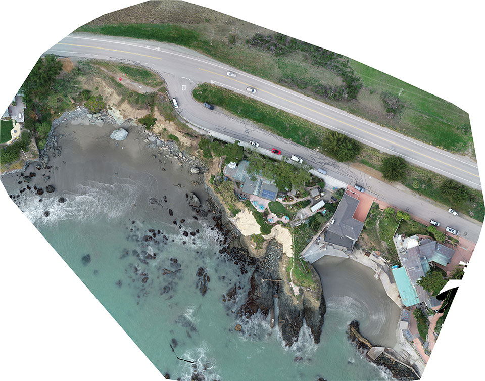
Cliff surveys are traditionally performed with fixed-wing aircraft that collect nadir photos. However, a photogrammetry company accurately triangulated oblique images and mapped them in 3D stereo, developing a new technique in the process.
The erosion survey — along Pacific Coast Highway 1 in Cayucos, California — required imaging the side of the cliff to produce a precise orthomosaic and topographic map of its structure and integrity. The project required a 0.5-inch orthomosaic, a 1.2-inch 3D topographic contour map and a vector-based digital terrain model accurate to 1.2 inches.
Surveyor Paul Reichardt and Robert Lafica, owner of Central Coast Aerial Mapping, placed ground control points around the property and beach, and then used a Trimble R8 GNSS receiver to measure their positions to within 0.04-foot accuracy. They also established four checkpoints for quality control in the photo triangulation process. The R8 and a Trimble 5600 total station were used to collect property corners and top-of-surface elevations to integrate into the 3D topographic map.
At an altitude of 131 feet, the UAS covered the site from both nadir and oblique camera angles in nine passes, collecting 158 photos at an average ground sample distance of 0.5 inches. To capture the cliff side, Lafica flew the UAS about 90 feet from its face and angled the camera at 40 degrees.
The photos and position data were loaded into Trimble’s Inpho UASMaster photogrammetric software to automatically triangulate the images. The software pinpointed 6,368 common features with multiple connections to match images to each other. After initial triangulation, precise coordinates were attached to each control point, a final triangulation was completed to create the maps, and a new technique for mapping cliff faces was born.
In September 2019, the Xinjiang Institute of Ecology and Geography conducted a nine-day project on the Heishan Mining Zone in Toksun County, Xinjiang Province, China.
The CHCNAVBB4 UAV was combined with the AlphaUni 900 lidar solution to capture data and produce a topographic map of the mining area at a scale of 1:500. The point-cloud data was collected for subsequent 3D modeling to facilitate asset management and inventory work.
In another project, CHCNAV provided training and equipment for a China Railway No. 10 Engineering Bureau project. For this project, CHCNAV’s BB4 UAV was combined with the AlphaUni 1300 lidar system and deployed to study the topography of the tunnel mouth in Liangshan, Sichuan province.
The BB4 is a high-end unmanned aerial system resulting from an alliance between the two companies in their respective segments. Its scientific design and highly integrated production technology come from CHCNAV — a global manufacturer specialized in efficient geospatial measurement technologies — and its fully automated flight control system from DJI, pioneer in the manufacture of commercial UAVs.
The AlphaUni 900 and AlphaUni 1300 are high-end multi-platform lidar systems, designed and improved by CHCNAV through many years of exploration and data-capture experience. Both are fully integrated systems with high-precision, long-range laser scanners that provide unique waveform lidar technology from Riegl and a high-accuracy inertial navigation system.
The AlphaUni systems can take on demanding surveying missions in the air and on the ground that require the highest quality of data.
Rokubun has launched JASON, a satellite navigation service for accurate geolocation. With JASON, users can achieve highly accurate geolocation without a base station, Rokubun said.
JASON works under a “freemium” pricing model, making it possible to use it for free or to subscribe to monthly professional or premium plans.
JASON is a post-processed kinematic (PPK) satellite positioning service in the cloud that allows users to achieve highly accurate geolocation by uploading GPS/GNSS campaign data. JASON will try to obtain the best possible positioning solution on a best-effort basis. It will use PPK with the nearest GNSS continuously operating reference station (CORS) in the service’s database or with he user’s own provided station if no close CORS are available, or precise point positioning. The data can be processed interactively by using the Rokubun website or automating the workflow via the Rokubun API.
JASON also features a free data-conversion service for GNSS raw measurements.The service is compatible with Argonaut, u-blox, Septentrio, Android GnssLogger and any receiver able to export industry standard RINEX v2 or v3 file formats.
According to Rokubun’s CEO Xavier Banqué-Casanovas, JASON cloud service allows users to get the best possible performance out of their GNSS equipment using an internet browser, without the need for special installation or updates requirements.
Oxford Technical Solutions has released the xNAV650, the latest in its line of inertial navigation systems (INS), suitable for use on drones.
INS provide surveyors with absolute position, timing and inertial measurements (heading and pitch/roll) that they can integrate into their survey projects. The measurements, when combined with data from other devices (such as lidar sensors and cameras), can greatly enhance the surveying process, leading to a greater return on investment, according to the company.
The xNAV650 is OxTS’ smallest, lightest and most affordable INS to date. It combines 20 years of navigation experience with the latest micro-electromechanical (MEMS) inertial measurement unit (IMU) technology and survey-grade GNSS receivers.
UAV Guidance
The xNAV650 provides highly accurate and reliable measurements – even when payload size and weight are imperative to consider, including for use with unmanned aerial vehicles (UAVs). It measures 77 x 63 x 24 mm and weighs 130 grams.
The xNAV650 INS is suitable for a wide range of UAV data-collection applications, including surveys of bridges, buildings, forests and rail; coastal monitoring; map creation and pipeline exploration.
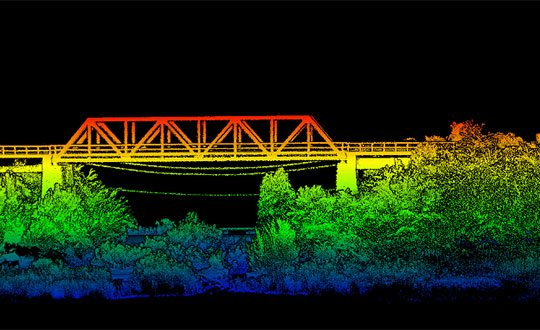
OxTS’ partner Dronezone used the xNAV650 INS and a Velodyne VLP-16 lidar on a drone to conduct a scan of an aging bridge to look for structural and potential hazards from overgrown foliage.
By fusing the timing, position and inertial data from the INS with the raw data of the Velodyne VLP-16 (using OxTS’ lidar georeferencing software OxTS Georeferencer), the surveyor was able to produce a highly accurate 3D point cloud of the bridge. Fusing the position and inertial data from the xNAV650 INS with the Velodyne VLP-16 lidar data provides a high level of clarit, which can be seen in the foliage, electricity lines and side of the bridge.
The resulting point cloud has enabled the engineers to easily and accurately pinpoint areas of the bridge that need closer attention.
Side view point cloud of bridge. Data collected using and OxTS xNAV650 INS and Velodyne VLP-16 lidar. Data processed using OxTS Georeferencer. (Image: OxTS)
NAVsuite Software
Data from OxTS INS can be fused with the data from almost any lidar sensor. Using OxTS Georeferencer software, point clouds can be georeferences from lidar units specifically from Velodyne, Hesai and Ouster sensors. Work is underway to integrate new lidar sensors from an even wider range of manufacturers into OxTS Georeferencer – allowing OxTS INS users to build a full navigation solution where much of the integration work is already taken care of.
OxTS NAVsuite software is included with all OxTS INS. The full range of software tools allows users of OxTS’ devices to configure and post-process data with ease.
Other optional software features are also available, including Precision Time Protocol (PTP) and GX/IX tight-coupling technology. PTP allows for a much simpler lidar survey set-up over ethernet while simultaneously stamping out time-drift by utilizing the high-quality INS clock source – GNSS. GX/IX tight-coupling technology, OxTS’ own proprietary navigation engine, ensures that users of OxTS Inertial Navigation Systems receive the most accurate measurements possible even in tough GNSS conditions.
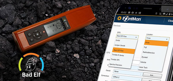
Mapping company ProStar Holdings Inc. and survey device company Bad Elf have partnered to produce a solution designed to gather the precise location of surface and subsurface utility data.
PointMan combined with Bad Elf is designed to quickly and precisely, locate, identify and display critical surface and subsurface utility data.
Bad Elf’s survey-grade GPS/GNSS receiver combined with ProStar’s flagship mobile-mapping solution, PointMan, now provides a powerful and user friendly solution for any industry requiring precision mapping including subsurface utility engineering (SUE) and utility locating professionals.
“The Bad Elf Flex was quickly configured by ProStar and performed flawlessly with the PointMan app. We found that consistent high accuracy was easy to maintain while collecting data,” said Larry Fox, vice president of marketing and business development at Bad Elf. “The depth of collection tools and export facilities exceeded our expectations. Given the seamless integration with Bad Elf Flex, PointMan demonstrated it’s a top-tier app for utility management, and expands our ability to provide best in class solutions to our users worldwide.”
“Equipment manufacturers like Bad Elf and their distribution networks are an important component of our sales and marketing strategy,” said Page Tucker, CEO and founder of ProStar. “Our goal is to continue to work with leading equipment manufacturers around the world to provide the most comprehensive, modern, and low-cost data collection solutions.”
ProStar’s flagship product, PointMan, is natively cloud and mobile, offered as a Software as a Solution (SaaS). ProStar’s solutions are being adopted by some of the largest entities in North America, including Fortune 500 construction firms, the largest subsurface utilities engineering (SUE) firms, and government agencies.
ProStar’s strategic partnerships are with geospatial technology and data-collection equipment manufactures and their dealer networks, including Trimble, Juniper Systems, Vivax-Metrotech, Radiodetection, Bad Elf and Subsite Electronics.
With the program and a construction GNSS receiver, a supervisor, foreman, grade checker or site engineer can easily check a grade, slope or alignment and navigate the project more accurately and in less time than with traditional survey methods. It can also give more personnel on the jobsite access to survey technology, enabling more productive and efficient field crews.
Trimble Siteworks SE Software is a simplified version of Trimble Siteworks Software, intended for users who do not require a full feature set and are interested in a lower-cost version to connect to GNSS only. The same colorful graphics, natural interactions and gestures, and self-discovery features found in Trimble Siteworks make the software easy to learn, so both experienced and new users can get up-to-speed quickly, Trimble said.
Using the same data folder structure, file formats and workflows, Trimble Siteworks SE Software is fully compatible with Trimble Siteworks Software. Contractors can easily upgrade to the full version, making Siteworks SE an ideal entry point into construction technology for surveying.
For contractors, Trimble Siteworks SE Software enables contractors to determine the location on a project, see cut/fill values to a design surface or alignment, or visualize constructible models in 3D. Users can measure feature (non-surface) points, lines and areas, or navigate to points, lines and alignments, and create PDF reports.
In vehicle mode, users can capture high-accuracy measurements on steep slopes from a moving vehicle. Trimble Siteworks SE is compatible with a wide range of GNSS hardware configurations.
Trimble Siteworks SE can share up-to-date information wirelessly between the field and the office to increase operational efficiency and reduce downtime.
The Frontier Precision 2021 TechXpo User Conference takes virtual its popular and informative in-person user conferences, sponsored by Frontier Precision for the past two decades. The conference will take place March 30-April 1, 11 a.m. to 5.pm. Central Daylight Time.
During the 2021 TechXpo, participants can engage in more than 70 webinars, live question-and-answer sessions, daily prizes and a virtual trade show with more than 15 industry vendors such as Trimble, DJI, Yellowscan and more.
Participants will learn new ways to measure, with a wealth of knowledge to be learned and shared, the company said.
“We’ve continued to take our core values of customer service and training, and be the first to bring new technology to the customer as a basic part of our DNA as a company,” said Dennis Kemmesat, Frontier Precision president and CEO.
The virtual conference is highly interactive, making information and technology accessible from a desktop whether in another city, another state, or somewhere on the other side of the world.
The three-day conference will explore the best technology from the engineering, land survey, geospatial information systems (GIS), construction and unmanned aerial system (UAS) industries.
The $49 registration includes 30-day access to recordings.
About Frontier Precision. Frontier Precision is an employee-owned company with 33 years of experience serving survey, mapping, engineering, construction, GIS, forensics, law enforcement, forestry, water resources, mosquito and vector control, and natural resources professionals.
As one of the top Geospatial Trimble dealers in the world, Frontier Precision has been at the forefront of technology. The company provides business solutions in the areas of UAS/drones, laser-based scanning, 3D visualization and virtual reality.
The company is headquartered in Bismarck, North Dakota, with locations in South Dakota, Minnesota, Colorado, Montana, Idaho, Oregon, Washington, Alaska and Hawaii.
A roundup of recent products in the GNSS and inertial positioning industry from the March 2021 issue of GPS World magazine.
OEM
GNSS Receiver
1-cm accurate multi-band receiver
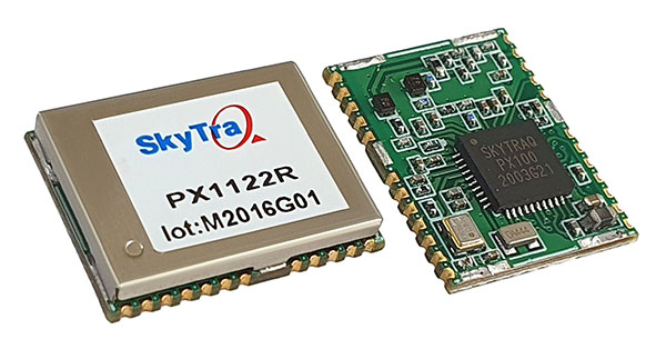
Photo: SkyTraq
The PX1122R is a 12 x 16 millimeter multi-band real-time kinematic (RTK) receiver for centimeter-level-accuracy positioning applications. It uses GPS L1/L2C, Galileo E1/E5b, GLONASS L1/L2 and BeiDou B1I/B2I signals concurrently to maximize positioning availability even in difficult urban environments. A single-chip system-on-chip, the PX1122R is designed to deliver reliable positioning for autonomous unmanned ground or aerial vehicles, the internet of things, and traditional land surveying and precision farming applications. It has an RTK initialization time under 10 seconds and a maximum update rate of 10 Hz. Its update rate provides in-time positioning with a fast response time and improved guidance for fast-moving applications. Moving-base RTK for GNSS precise heading is also supported.
SkyTraq, www.skytraq.com.tw/homesite/
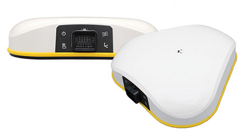
Iridium antennas
Available housed or embedded
Photo: Tallysman
The housed HC610 and embedded HC610E active Iridium antennas operate in receive-only mode and enable Iridium terminals to be installed tens of meters away from the antenna. The lightweight and compact helical antennas are designed to receive the Iridium Satellite Time and Location (STL) signals. Both antennas are light and compact and feature a precision-tuned helical element that provides an excellent axial ratio and operates without a ground plane. They feature a low-current, low-noise amplifier (LNA) and pre-filter to prevent harmonic interference from high-amplitude signals, such as 700-MHz band LTE and other nearby in-band cellular signals. The housed HC610 weighs 23 grams, is 33 x 54.2 mm, and features an IP67 robust, military-grade plastic enclosure, with a base-mounted male SMA connector and two screw holes for surface attachment. At 10 grams, the embedded HC610E is 27.5 x 38.7 mm and can be installed in a custom enclosure. It provides a base-mounted female MCX connector. An optional embedded helical mounting ring is available to attach the antenna to a flat surface.
Tallysman Wireless, tallysman.com
Receiver front end
Designed for portable receivers
Photo: STMicroelectronics
The BPF8089-01SC6 GNSS receiver front end integrates the impedance-matching and electrostatic discharge protection circuitry typically implemented using discrete components. It provides a 50-ohm matched interface between the receiver’s antenna and LNA, and is ready for plug-and-play with the company’s STA8089 and STA8090 LNAs. It is suitable for use in portable receivers for the GPS, Galileo, GLONASS, BeiDou and QZSS constellations, which can be used in applications such as consumer satellite navigation, radio base stations, drones and tracking of assets or livestock.
STMicroelectronics, st.com
GNSS/INS board
Enhanced with an inertial measurement unit
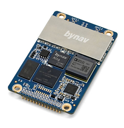
Photo: Bynav
The Bynav A1 is a compact GNSS OEM board with a highly integrated tactical-grade inertial measurement unit (IMU) on board. With Bynav’s new-generation RTK algorithm engine and deeply coupled GNSS/INS algorithm engine, the A1 can provide continuous, reliable high-precision positioning, 3D attitude and velocity to applications such as autonomous driving, robotics, UAVs and mobile mapping. Weighing 25 g and measuring 46 x 71 millimeters, the credit-card-sized A1 is easy to integrate into any system while providing enhanced connection options including serial, Ethernet and CAN.
Bynav Technology, bynav.com
SURVEYING & MAPPING
GNSS/IMU receiver
With tilt compensation
Photo: ComNav
The N5 IMU RTK receiver is user-friendly, with up to 60° tilt compensation ensuring quick measurement and precise position acquisition. A combination of high-end inertial measurement unit (IMU) and advanced GNSS real-time kinematic (RTK) technology, along with ComNav’s core algorithm, ensures high accuracy of less than 2.5 cm, making surveying and mapping in difficult environments easier. The N5 receives all current and future GNSS signals: GPS, GLONASS, BeiDou, Galileo and SBAS. The high-quality OLED display with sunlight readability provides clear viewing and allows users to handle all surveying operations on the screen. A 6800mAh Li-battery allows more than 15 hours of continuous work.
ComNav Technology, www.comnavtech.com
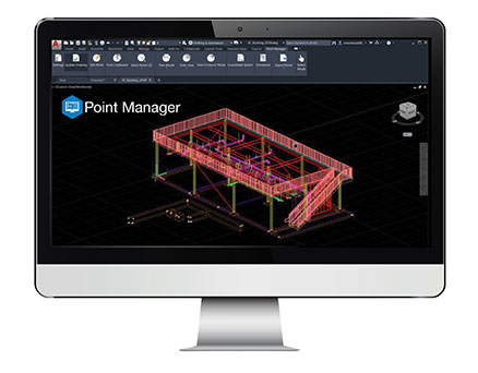
Point creation software
Imports/exports layout files
Photo: Topcon
Topcon Point Manager software is available as a plug-in for Autodesk AutoCAD and Autodesk Revit users in the United States and Canada. It automates point creation and imports and exports layout files to and from a robotic total station. Users will be able to access the solution as a plug-in component to their design package, creating multiple points on building information modeling (BIM) objects and 2D/3D drawings from within the Autodesk environments. Quality assurance and control efforts are improved with point and deviation reports, a likely reduction in on-site personnel, and avoidance of costly errors. Topcon MAGNET users can wirelessly send points to the field for layout, and completed layout files can be sent back to the office to update the model to match as-built conditions.
Topcon, topcon.com
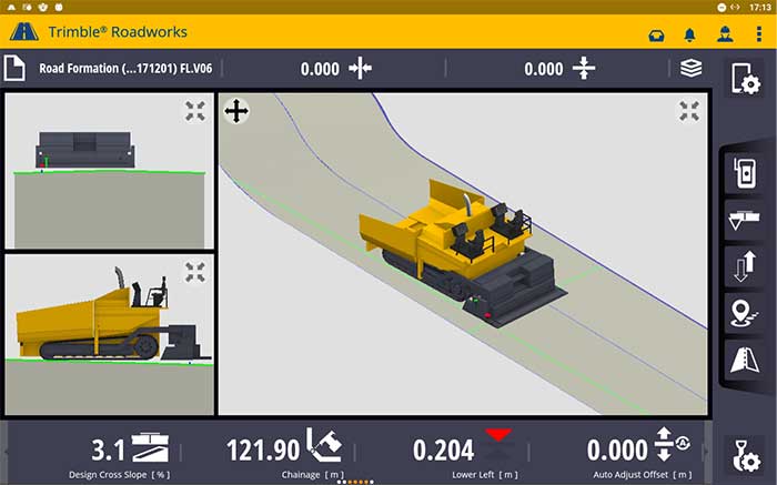
Paving control platform
Directly references design
Screenshot: Trimble
The Trimble Roadworks 3D Paving Control Platform is an accurate, automatic 3D screen control system. It can improve paving productivity and rideability by directly referencing the design rather than a surface or stringline to minimize asphalt usage, reduce waste and overruns, enabling users to finish projects on time and under budget. The Android-based application runs on the 10-inch touchscreen Trimble TD520 display. Operators can personalize the interface to match their workflows, and configurable views make it easier to see the right perspective. The software uses components from Trimble Earthworks, and users can download third-party applications.
Trimble, trimble.com
RTK Receiver
Out-of-the-box features
Photo: Emlid
The Reach RS2 is a full-featured multi-band RTK receiver. All of its features are available out of the box, along with a survey app for iOS and Android. The Reach RS2 tracks L1/L2 bands on GPS, GLONASS and BeiDou, and L1/L5 on Galileo, and acquires a fixed solution in seconds. It achieves centimeter-level precision for surveying, mapping and navigation, and maintains robust performance even in challenging conditions. Centimeter accuracy can be achieved on distances up to 60 km in RTK and 100 km in PPK mode. It provides up to 22 hours of autonomous work when logging data and up to 16 hours as a 3G rover, even in cold weather.
Emlid, emlid.com
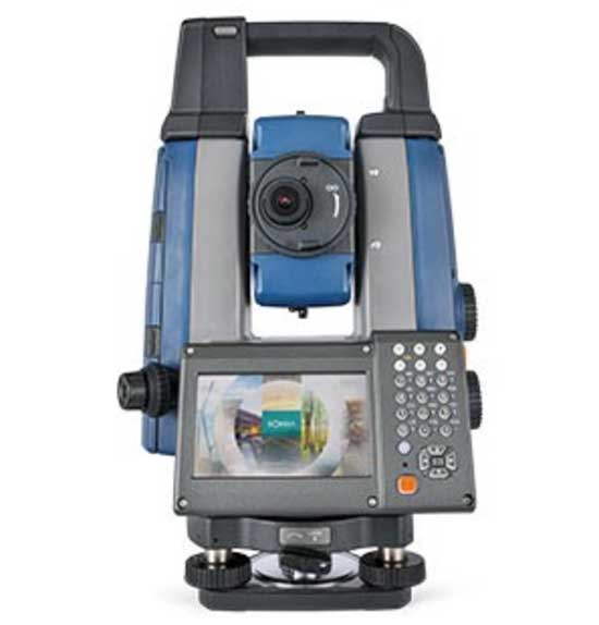
Total stations
Integrate with GNSS
Photo: Sokkia
The iX-1200 and iX-600 robotic total stations are designed to be a part of a workflow solution for survey and layout in construction and infrastructure. They’re engineered for integration with field controllers, software and GNSS receivers. Users can switch to total station measurement integrated with GNSS through an optional upgrade. The stations also can be seamlessly integrated into BIM workflows.
Sokkia, sokkia.com
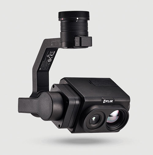
UAV
Thermal Payload
High-resolution gimbaled dual-thermal zoom
Photo: FLIR
The FLIR Vue TZ20 plug-and-play payload is fully integrated with the DJI V2 Matrice 200 and 300 series airframes. With 20X zoom capabilities, the FLIR Vue TZ20 provides drone pilots from the public safety and industrial inspection sectors with improved image detail and magnification to assess situations and make critical decisions. The 2x to 20x zoom provides a wide 95-degree field of view for maximum situational awareness, covering large areas in a single flight, or a narrow 18-degree field of view to put more pixels on target when needed. Factory calibrated, the dual 640 × 512 Boson thermal cameras are equipped with expandable infrared video streaming at 30 Hz.
FLIR, flir.com
Fixed-wing UAV
For surveyors, GIS professionals
Photo: SenseFly
The eBee Geo represents the first extension into a new eBee X series of fixed-wing UAVs and is positioned as a cost-effective option for surveyors and GIS professionals who may be unfamiliar with fixed-wing UAV mapping and data collection. With a maximum 45-minute flight time, the eBee Geo can achieve single-flight coverage of 160 ha at 122 m (395 A at 400 ft), suitable for smaller surveying firms and project-based drone service providers. Construction, urban planning and land management users can also benefit from the RGB imaging capabilities of the supplied senseFly S.O.D.A. camera fixed payload, while achieving greater efficiency and absolute accuracy down to 2.5 cm from the eBee Geo’s real-time kinematic (RTK) function. The eBee X is a premium version that offers users the high-precision of on-demand RTK/PPK for achieving absolute accuracy of down to 1.5 cm (0.6 in) without ground control points. Customers also have access to senseFly’s intuitive eMotion flight planning software.
SenseFly, sensefly.com
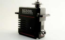
Actuator
With CAN and UAVCAN connectivity
Photo: Hitec Commercial Solutions
The SG50BL actuator includes CAN 2.0 A/B or UAVCAN control options. It is designed with robust steel gears and a high-performance brushless motor. It is capable of operating at 18 to 32 volts. The actuator features a programmable digital circuit with a MOSFET amplifier; a BLDC motor; a magnetic encoder position sensor; five hardened steel gears with low gear backlash (less than .5°); a four ball-bearing supported output shaft; and nine needle bearing supported idlers. It has a rugged anodized aluminum alloy case and an IP68 waterproof rating. The SG50BL also is capable of 360° proportional rotation and has T4131012051-000 TE connectivity. Custom connector options are available.
Hitec Commercial Solutions, hitecnology.com
Smart antennas
Designed for tough environments
Photo: Trimble
The AX940 and AX940i high-precision GNSS smart antennas are designed for a range of high-precision applications, including UAVs. With multi-frequency, multi-constellation support for GPS, Galileo, GLONASS, BeiDou, QZSS and NavIC, the smart antennas can deliver reliable centimeter-level accuracy in a variety of environments. In addition, the Trimble AX940 and AX940i provide reliable, high-accuracy positioning without the constraints of a local base station or cell modem by using Trimble RTX correction services. Built-in inertial sensors on the AX940i allow a tight integration with GNSS observations in the RTK/RTX positioning and orientation engine, providing continuous high-rate low-latency output to guidance and control systems. The Trimble AX940 and AX940i provide flexible interfaces with high-speed data transfer and configuration; simplified integrations reduce development times; and an intuitive 3D graphical web page allows easy input of the lever arm for easier set up.
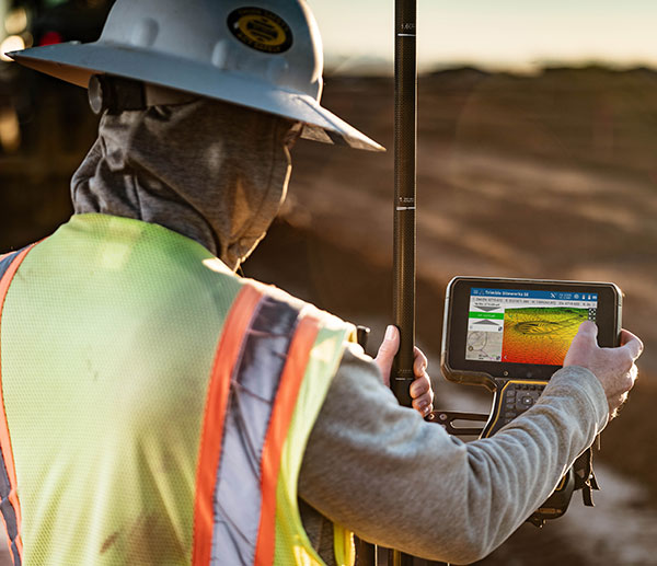
The Trimble TSC5 Controller boasts a 5-inch screen, keypad keypad and all-day battery. (Photo: Trimble)
Trimble has released the TSC5 Controller, a rugged, lightweight field data controller for land construction and surveying.
According to Trimble, the TSC5 Controller, built for practical, everyday tasks, combines high performance and dependability so professionals can complete tasks efficiently and accurately.
“Surveyors expect to encounter challenging environments and must rely on their equipment to perform as expected in harsh conditions,” said Ron Bisio, senior vice president, Trimble Geospatial. “The TSC5 controller is a high-value, reliable solution that land surveyors can leverage for field data collection tasks performed all day, every day.”
The controller has a 5-inch screen, keypad keypad and all-day battery for reliable field data collection. It also is resistant to shock, dust and water, and features an anti-glare screen and backlit alphanumeric keypad.
The Trimble TSC5 Controller uses an Android 10 operating system and is fully integrated with Trimble’s land and construction surveying instruments and software packages, including Trimble Access 2021 Field Software, Trimble Siteworks Software. It’s also compatible with the Trimble EMPOWER Module system, which includes the ability to add the EM100 (GNSS), EM11X family (RFID/Barcode) and EM120 (long-range radio) modules.
“Civil construction surveyors trust Trimble to provide rugged, reliable hardware that connects them to the Trimble Connected Construction ecosystem,” said Scott Crozier, vice president, Trimble Civil Construction. “The TSC5 is a great addition to our family of connected controllers, giving contractors the ability to choose the solution that best fits their needs and budget.”
The Trimble TSC5 Controller running the Trimble Access field software is now available through Trimble’s geospatial distribution partners.
The Trimble TSC5 Controller with the Siteworks SE Starter Edition. (Photo: Trimble)