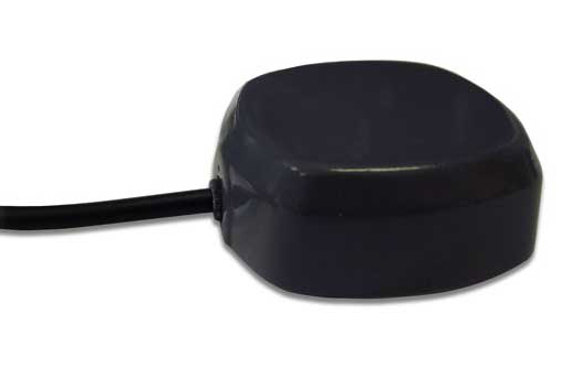
Two dual-feed GPS/GLONASS antennas from Tallysman’s GNSS antenna range are now available in Australia and New Zealand through M2M Connectivity. Tallysman is a Canada-based developer of high-performance GNSS antennas focused on the requirements for precision and multi-constellation GNSS receivers.
Featuring a dual-feed wide-band patch element, Tallysman’s TW2410 and TW4421 antennas cover the GPS L1, GLONASS G1 and SBAS (WAAS, EGNOS and MSAS) frequency band (1574 to 1606 MHz). The dual-feed patch provides excellent circular polarized signal reception, multipath rejection and out-of-band signal rejection, according to Tallysman.
Offering tight phase center variation (PCV), the antennas are suitable for high-accuracy applications and for use in precise point positioning (PPP) systems that require only a single frequency such as single-frequency RTK solutions, GNSS compasses and machine control.
Suitable for precision industrial, agricultural and military applications, the dual-feed GPS/GLONASS antennas feature Tallysman’s Accutenna technology that provides superior or multipath signal rejection and precision. The TW2410 and TW4421 antennas are housed in IP67 industrial-grade weather-proof, magnet mount enclosures and come with a wide range of connector options and cable lengths.
Tallysman is a manufacturer of high-performance, high-quality products for a wide range of GNSS applications.
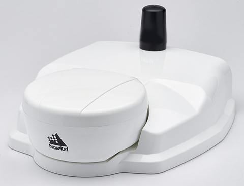
NovAtel’s SMART6-L attaches to the Relay RTK radio module to create a single unit for easy system integration.
NovAtel Inc. has launched the Relay RTK radio module, a docking station that provides radio connectivity for its SMART6-L L-band capable GNSS receiver.
The Relay RTK module combined with NovAtel’s SMART6-L receiver creates a compact, easy to integrate positioning solution, NovAtel said. It is available in four radio versions: 400 MHz UHF licensed band; 900 MHz UHF unlicensed band; HSPA (3G) cellular; and CDMA (1xRTT/EV-DO) cellular. The CDMA version is approved for use on the Verizon cellular network.
The 400 MHz and 900 MHz versions support both base and rover configurations. The base station is configured via the integrated web-server/Wi-Fi access point using the web browser on any compatible personal computer, tablet or smartphone. The cellular radio versions support the reception of NTRIP and RTK corrections over the cellular network.
SMART6-L customers can connect to the Relay using their existing SMART6-L interface cables. Relay has support for both screw and magnetic mounting; optional mounting plates are available for roof and pole mounting. NovAtel’s SMART6-L with Relay provides the same level of performance as a standalone SMART6-L unit with the added convenience of radio connectivity to support RTK and NTRIP corrections.
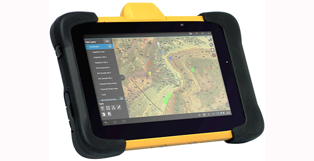
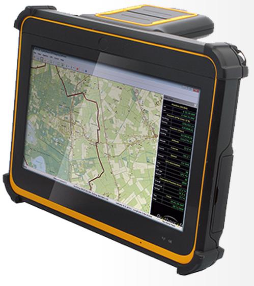
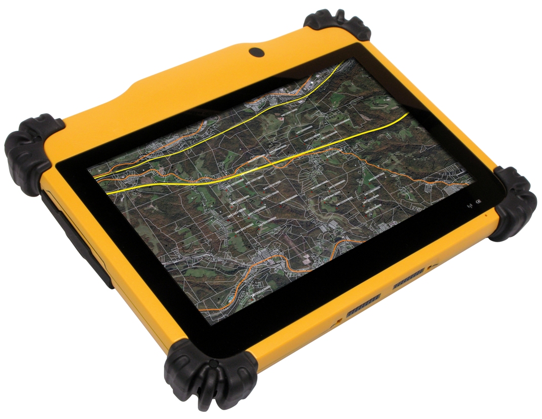
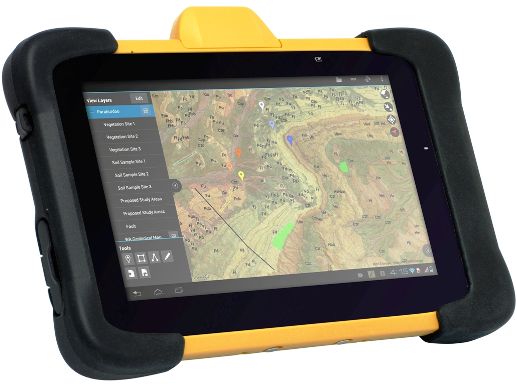
DT Research Inc. has launched a new line of rugged tablets with the GNSS modules for surveying and mapping applications. The DT391GS, DT395GS and DT307GS rugged tablets feature integrated high-accuracy GNSS receiver modules with built-in antenna for seamless data capture, the company said.
Built to travel and provide reliable operations in the real world, the tablets are designed for field work in mapping, geographic information systems (GIS), and accurate synchronization, tracking and networking.
The DT391GS combines a 9-inch sunlight-readable, capacitive touch display with an energy-efficient Intel dual-core processor in a compact, durable package. With the high-accuracy GNSS module options (Hemisphere or Trimble), the foldable antenna, and Windows or Android operating system. The DT391GS also offers protection in demanding environments with IP65 and MIL-STD-810G ratings for dust and water, and shock and vibration resistance.
The DT395GS tablet.
The DT395GS offers a 9-inch sunlight-readable capacitive touch screen, an energy efficient Intel dual-core processor, and a choice of Windows or Android operating systems. The GNSS positioning module has u-blox GNSS module. The IP65 rating, and military-standard MILSTD-810G and MIL-STD-461F ratings, as well as wide temperature range, make the DT395GS reliable even in harsh, mission-critical environments.
The DT307GS GNSS tablet features a brilliant 7-inch capacitive touch screen and a quad-core, energy efficient processor with a built-in, high-accuracy u-blox GNSS module. The size and weight of the DT307GS make this tablet portable for long-term handling in the field, DT Research said.
The DT307GS tablet
All of the DT Research Rugged GS Tablets offer hot-swappable batteries for continuous operation, enabling real-time project efficiency between staff in the field and in the office. With wireless support for Bluetooth, 802.11, WCDMA and HSPA+ connectivity and optional GSM networking, the tablets keep staff connected from any location.
The DT391GS and DT395GS have Trusted Processing Module (TPM) encryption for security support, and a choice of Microsoft Windows Embedded Standard 7 or 7 Professional, or Android operating system making these tablets flexible to integrate with existing applications.
An optional 5-megapixel camera offers another data capture tool to record visual information, and an optional 3G cellular data module provides data connectivity for navigation and real-time data transfer, DT Research said.
The DT391GS, DT395GS, and DT307GS are available now, form more information, contact DT Research at [email protected].
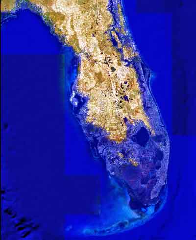
Image showing projected Florida flooding, from flood.firetree.net, using Google Earth with NASA data. Image from flood.firetree.net, using Google Earth.
Surveyors, prepare to get your feet wet. Global warming is about to hit you in the job list. By 2050, a majority of U.S. coastal areas are likely to be threatened by 30 or more days of flooding each year. This according to a December report in Earth’s Future, a journal of the American Geophysical Union.
[Parenthetically, the next issue of Survey Scene, in May, will be written by an actual geodesist. Until then, you have to put up with GPS World’s editor in chief — by no means a surveyor. Patience.]
The study used data from National Oceanic and Atmospheric Administration (NOAA) tide gauges to show the annual rate of coastal floods has accelerated in recent years. These are now five to 10 times more likely today than 50 years ago — and getting worse.
Mitigation decisions could range from retreating further inland to coastal fortification or to a combination of “green” infrastructure using both natural resources such as dunes and wetland, along with “gray” man-made infrastructure such as sea walls and redesigned storm water systems. And that’s not even mentioning such basics as redrawing property lines. Any way you look at it, surveyors are going to be involved.
“As communities across the country become increasingly vulnerable to water inundation and flooding, effective risk management is going to become more heavily reliant on environmental data and analysis,” said Holly Bamford, NOAA acting assistant secretary for conservation and management.
The recent U.S. Hydro 2015 conference in National Harbor, Maryland — an area particularly called out for vulnerability to the oncoming floods — naturally found a lot to talk about in this and related areas of interest for surveyors, with session tracks including: Effects of Climate Change on our Oceans and Waterways; Coastal and Ocean Mapping Initiatives; Advances in Unmanned System Technology, and several more.
Some of the papers presented that GPS World found of interest, and hopes to present or encapsulate in some form in the near future, include:
Resolving Systematic GPS Interference from Aeronautical Distance Measuring Equipment during Mission-Critical Shallow Water Multibeam Surveys
GPS Water-Level Buoy for Hydropgraphic Survey Operations
Examining the Uncertainty Associated with the Establishmenbt of an Ellipsoid to Chart Datum Separation Surface Using GNSS Buoys
Comparison of Horizontal and Vertical Resolvable Resolution between Repetitive Multibeam Surveys Using Different Kinematic GNSS Methods.
And those just came from the poster sessions. In the technical sessions, Jack Riley from the NOAA Coast Survey’s Hydrographic Systems and Technology Program presented a GPS Buoy Water Level Uncertainty Case Study.
Data from on High
Since you can’t get at a coastline from all angles — with any degree of stability, that is — data from overhead, sometimes far overhead, proves invaluable. Such as that provided by aerial digital imagery, LiDAR, and increasingly, satellites.
Because digital aerial images are already in electronic form, they can quickly be processed and made available to users. Most of the special cameras in use nowadays provide direct georeferencing capability, which allows camera position and orientation to be determined automatically using GPS and inertial measurement equipment. An entire mini-industry has grown up around integrating aerial data with that taken from ground surveys.
Light detection and ranging (LiDAR), a remote sensing system, became available for commercial topographic mapping in 1993. An airborne laser scanning system paired with a kinematic GPS receiver and an inertial navigation system can calculate and produce a highly accurate spot elevation. It is possible to obtain point densities that would likely take months to collect using traditional ground survey methods. The National Geodetic Survey (NGS) is currently implementing LiDAR into their shoreline mapping production process.
Our Record So Far
Coverage of these salty issues has been sparse in GPS World and associated newsletters, but not entirely absent. In 2006, the May issue featured “GPS Buoys Nautical Measurement.”
In 2008, Richard Langley edited an Innovation column on “Tsunami Detection by GPS,” featuring work for which co-author Attila Komjathy eventually won a GPS World Leadership Award in 2013. And in 2010, Langley brought forth an Innovation column on “Monitoring Water Level with GNSS.”
And way, way back in 2005, we published “Abreast of the Waves: Open-Sea Sensor to Measure Height and Direction.” This was prior to our digital era, so until we can scan a paper copy into here, we’ll simply give the abstract: “Accurate and timely information on open-sea wave conditions can help in preventing large-scale maritime disasters. This article describes a new, low-cost Global Positioning System (GPS)-based sensor that measures wave height with an accuracy of several centimeters and direction with an accuracy of 5 degrees. The receiver is mounted on a buoy, and a high-pass filter is used to extract the movement of the buoy and thus minimize GPS positioning errors. The data provided by the sensor is intended to improve wave prediction models. In addition, since this GPS-based sensor transmits only analyzed ocean wave data, it reduces the volume of data and leads to lower operating and acquisition costs. The article describes the concept of the GPS-based wave sensor, algorithms that are used for filtering and extracting wave data, as well as the results of open-sea trials.”
So there’s more to come. Watch this space. In the meantime, we leave you with Bob Dylan’s prophetic words, circa 1967.
Well, it’s sugar for sugar And salt for salt If you go down in the flood It’s gonna be your own fault.
2015 GNSS Market Report: European GNSS Agency Provides a Fresh Look at Worldwide Growth
The fourth edition of the European GNSS Agency’s (GSA’s) GNSS Market Report provides a comprehensive source of knowledge on this dynamic global market. The report has become a key reference for organizations building their GNSS market strategies. The new edition provides:
Comprehensive updates on previous analyses;
New statistics of the GNSS receiver capabilities of the 31 top global manufacturers, offering in total more than 300 models;
Insights on the GNSS industry and regional shares of the GNSS market
A more granular segmentation of the global GNSS market, namely: European Union (EU28); North America (including the United States, Canada, Mexico); Asia-Pacific (including China, Japan, Australia, India, Republic of Korea); Non-EU28 Europe (Norway, Switzerland, Russia, Ukraine); Middle East and Africa (Turkey, Israel, South Africa, UAE, Saudi Arabia); South America and Caribbean (including Brazil, Argentina, Colombia, Guatemala)
Information on a new market segment: Timing and Synchronization
Plus additional applications within existing segments, such as recreational navigation, fishing vessels, personal locator beacons, emergency locator transmitters and digital tachograph.
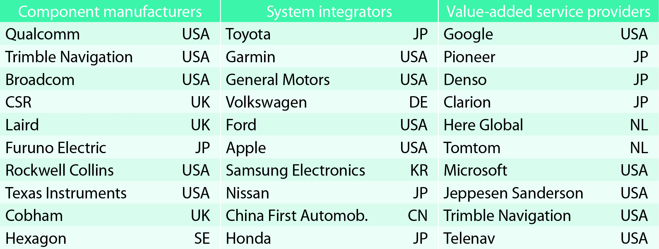
TABLE 1. Top 10 companies in each group based on 2012 revenue.
Key Findings
Top-line insights from the fourth GSA GNSS Market Report:
The global GNSS downstream market is forecast to increase by 8.3 percent annually from 2013– 2019, then slow down to 4.6 annually around 2023, growing on average faster (7 percent) than the forecast global GDP in this period (6.6 percent).
The installed base in the mature regions of EU28 and North America will grow steadily (8 percent per year) to 2023. The primary region of growth will be Asia-Pacific, which is forecast to grow 11 percent per year from 1.7 billion in 2014 to 4.2 billion devices in 2023 — more than the EU and North America together. The Middle East and Africa will grow at the fastest rate (19 percent per year), but starting from a lower base.
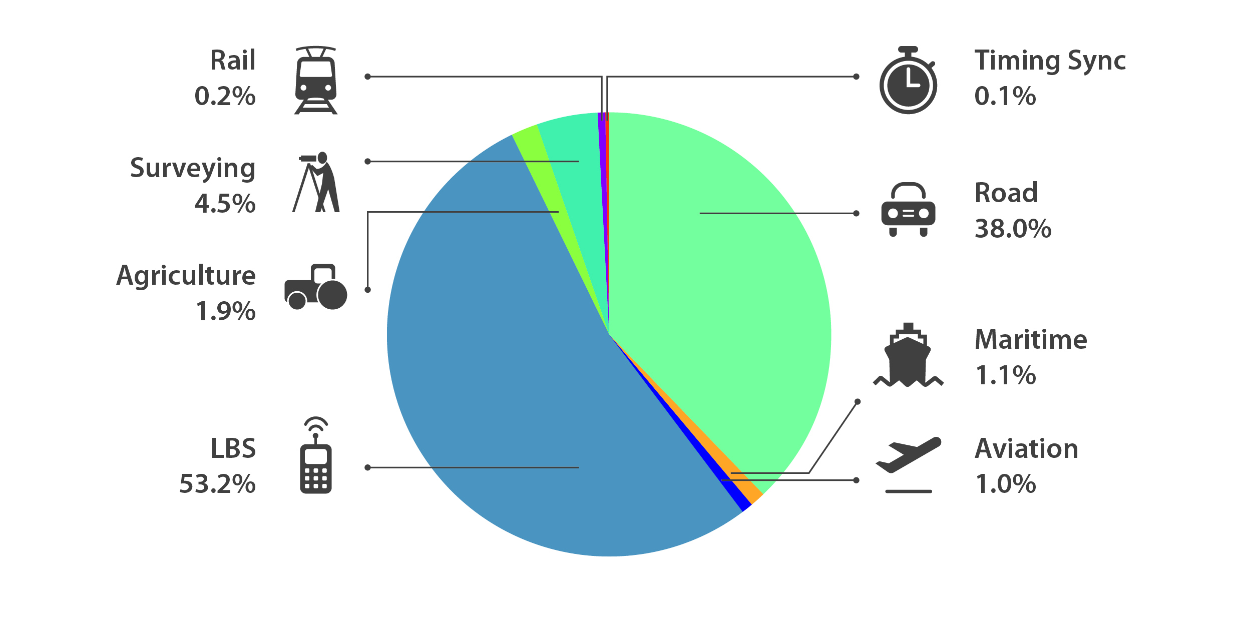
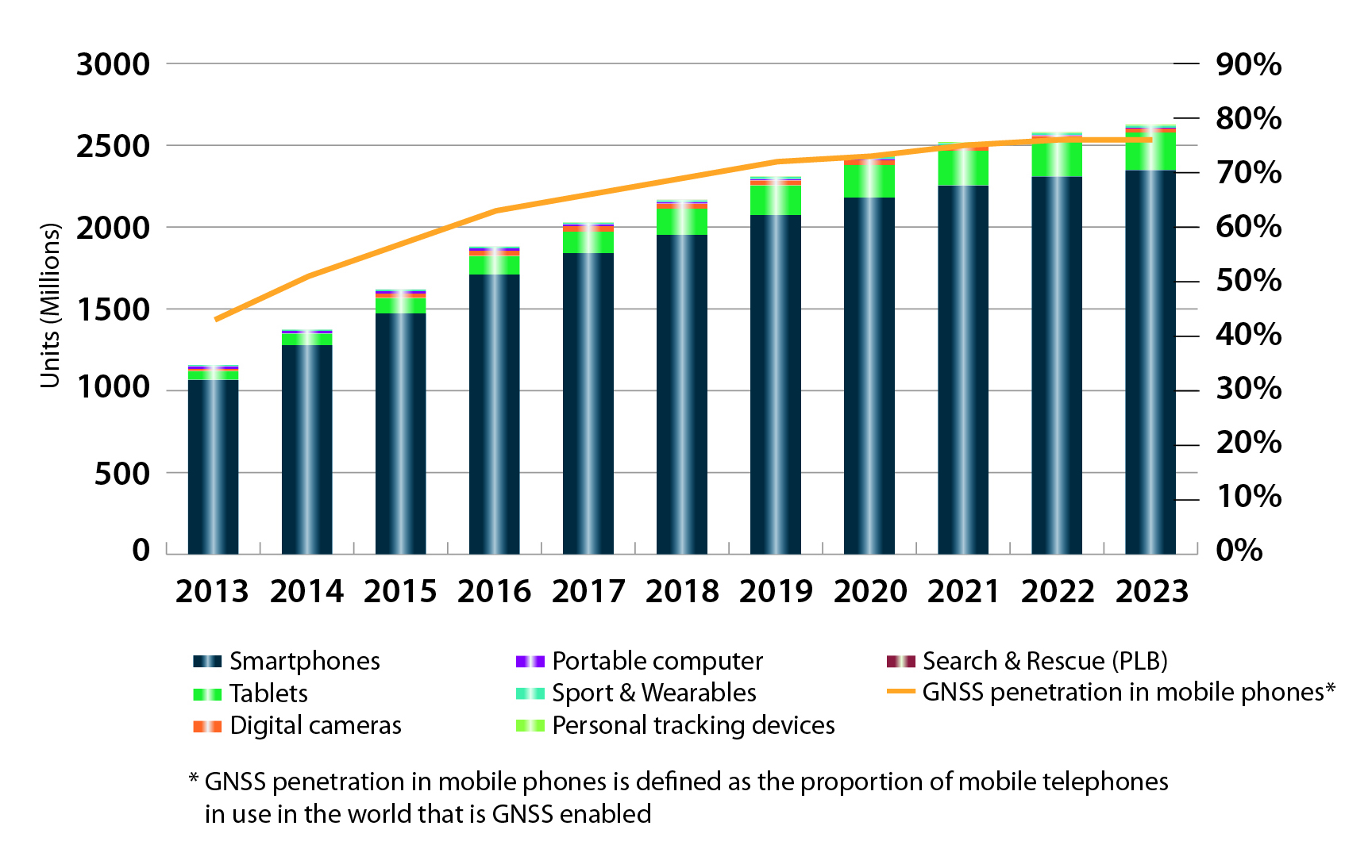
Location-Based Services (LBS) and Road dominate cumulative GNSS revenues, driven by booming sales of smartphones and in-vehicle devices, location-aware applications and data services.
With emerging economies catching up in terms of GNSS devices per capita, the Digital Divide will narrow, driven by the take-up of smartphones. The growing dominance of smartphones (3.08 billion in 2014) is foreseen as the most popular platform to access LBS.
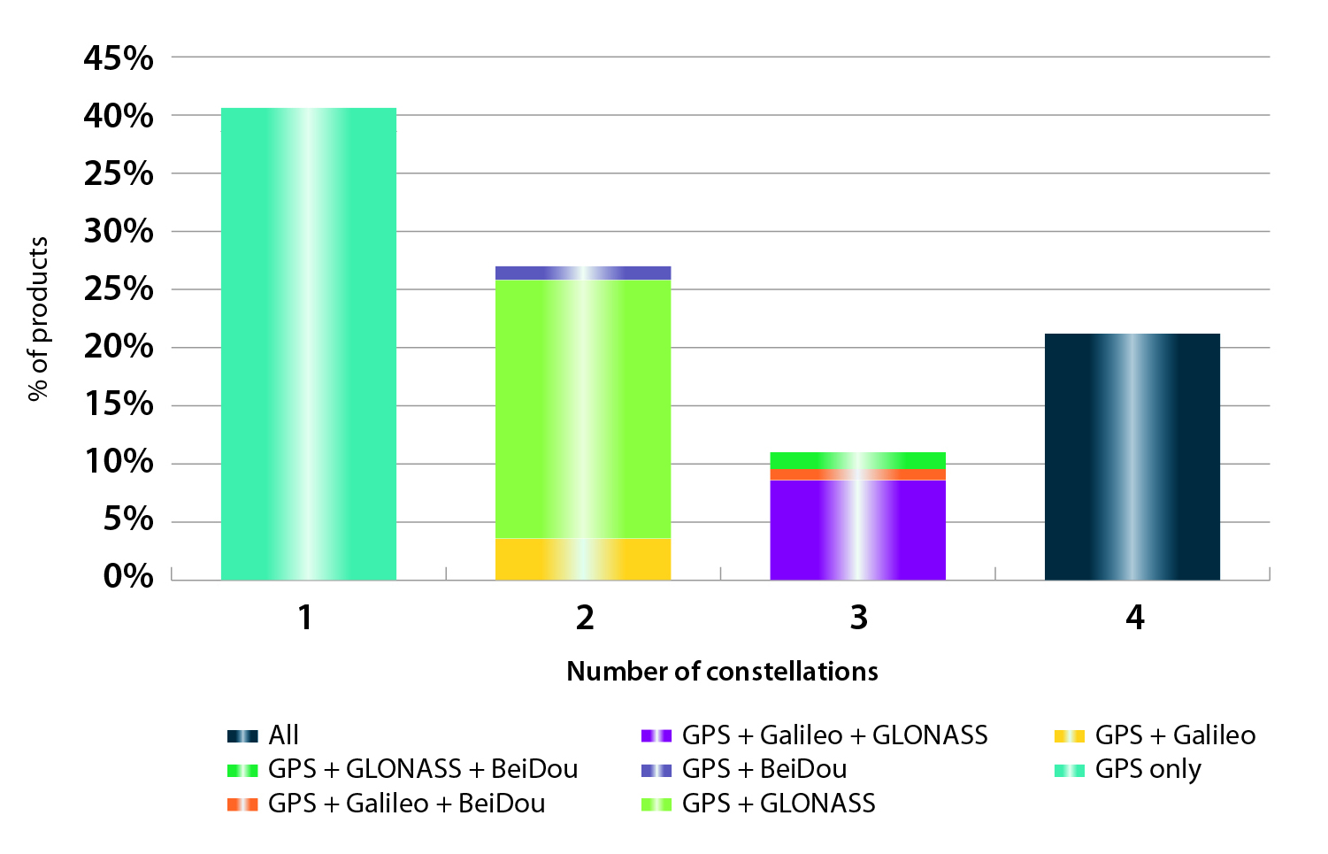
In the analysis of the capabilities of GNSS receivers and chipsets, it is reported that more than 60 percent of currently available receivers and chipsets support a minimum of two constellations with more than 20 percent supporting all four of them.
FIGURE 2. SUPPORTED CONSTELLATION BY RECEIVERS Chart shows the percentage of available receivers capable of tracking signals from one GNSS (such as GPS only), two GNSS (GPS + Galileo, GPS + GLONASS, GPS + BeiDou), three GNSS (GPS + Galileo + GLONASS, GPS + Galileo + BeiDou, GPS + GLONASS + BeiDou) or tracking signals from all constellations at the same time. The percentages add up to 100 percent. We can conclude that almost 60 percent of all available receivers, chipsets and modules are supporting a minimum of two constellations, showing that multi-constellation is becoming a standard feature across all market segments.
New Charts
The report includes new infographics presenting:
Global GNSS downstream market size, core and enabled (2013 to 2023)
GNSS industry share by region (2012)
The global shares of companies among components manufacturers, systems integrators and value-added service providers (2012)
Capability of GNSS receivers and chipsets, all segments (2015)
Supported constellation by receivers and chipsets , all segments (2015)
Detailed analysis of key GNSS segments: LBS, Road, Aviation, Rail, Maritime, Agriculture, Surveying, Timing and Synchronization, quantified in terms of:
Shipments of GNSS devices by application and region (2013 to 2023)
Installed base of GNSS devices by application and region (2013 to 2023)
Core revenues from GNSS device sales by application and region (2013 to 2023)
Capability of GNSS receivers and chipsets (2015)
Supported constellation by receivers and chipsets (2015).
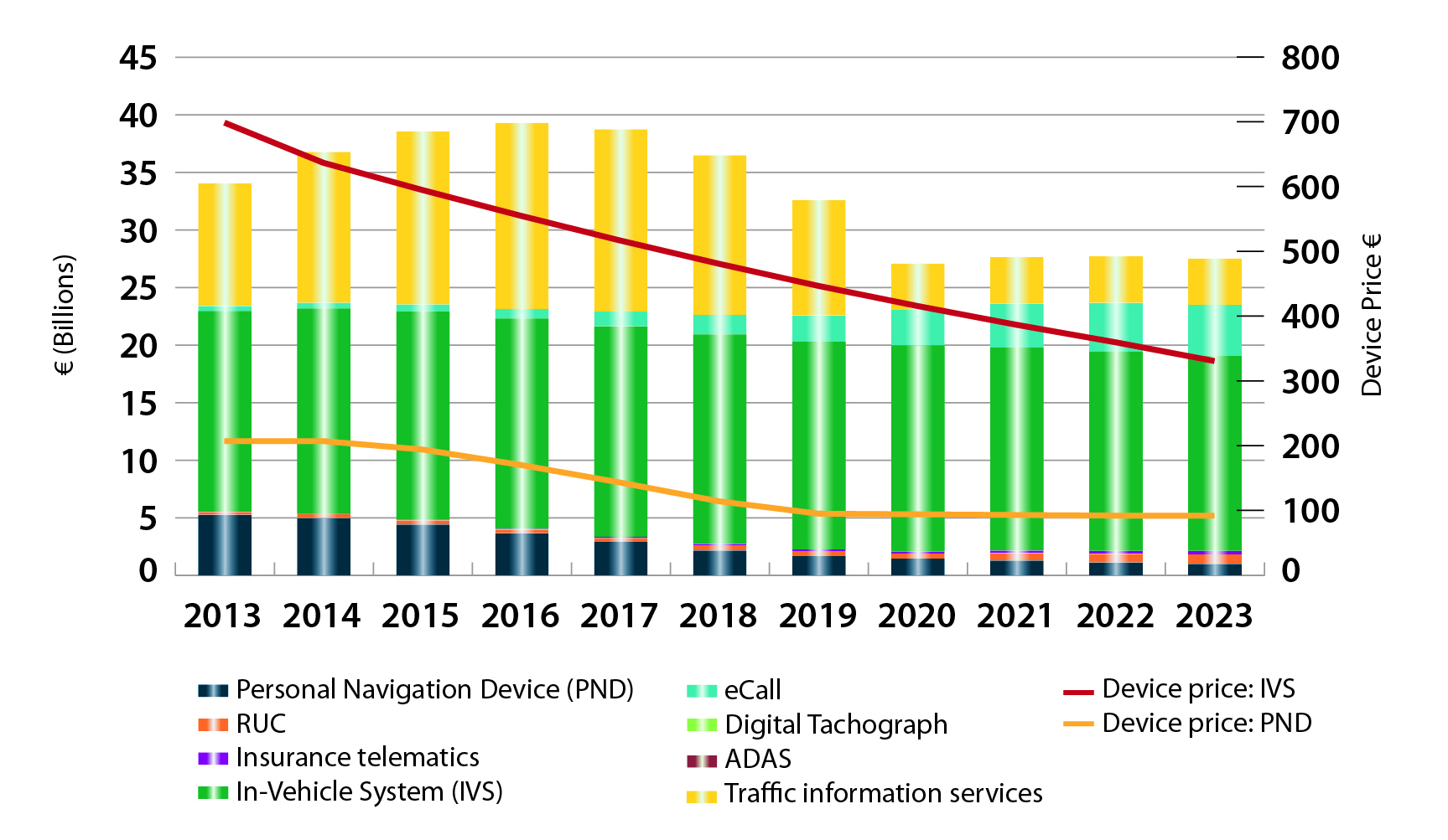
FIGURE 3. LOCATION-BASED SERVICES SECTOR GNSS shipments by type; GNSS penetration in mobile phones is defined as the proportion of mobile telephones in use in the world that is GNSS enabled.FIGURE 4. ROAD SECTOR Core revenue from GNSS device sales and services by application.
Methodology
The “GSA GNSS Market Report” is compiled by the GSA and the European Commission and was produced using the GSA’s systematic Marketing Monitoring and Forecasting Process.
The underlying market model uses advanced forecasting techniques applied to a wide range of input data, assumptions, and scenarios to forecast the size of the GNSS market in terms of shipments, revenue and installed base of receivers.
Historical values are anchored to actual data in order to ensure a high level of accuracy. Assumptions are provided by expert opinions and model results are cross-checked against the most recent market research reports from independent sources, before being validated through an iterative consultation process with sector experts and stakeholders.
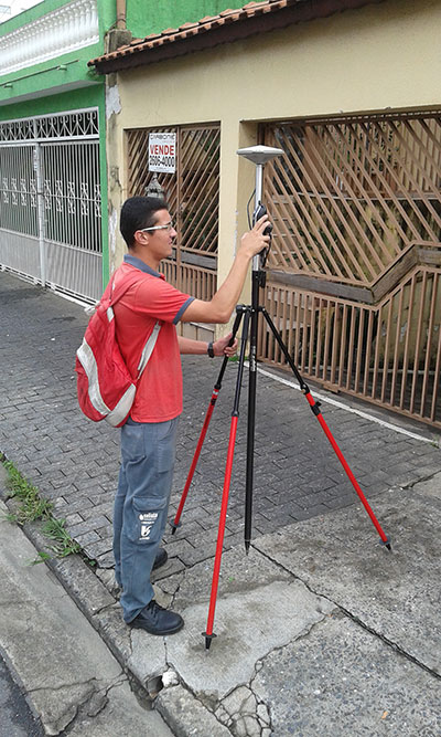
Saneamento Basico do Estado de São Paulo (SABESP), a Brazilian water and sewage collection utility owned by São Paulo state and Latin America’s largest water company by market capitalization, has selected Spectra Precision ProMark 120 and 220 GNSS receivers to assist in gathering the geographic location of all SABESP network assets and the location of all customers.
SABESP provides water to more than 28.7 million customers, or 67 percent of the population of São Paulo state. Water loss due to leakage in the SABESP network is a significant problem. The biggest reason behind water loss is leaks in the network; additional factors include sub-metering, caused by low water pressure; unauthorized consumption; and fraud.
Improving water management, recovering lost revenue and improving the quality of the customer experience is a priority for SABESP, Spectra Precision said. To help improve revenue generation and reduce water loss, SABESP developed two projects: LigGeo, to geo-reference the water meter location of approximately 4.8 million SABESP customers; and CadGeo, to geo-reference and register the location of the SABESP water and sewage network infrastructure.
According to Marcos Almir, sanitation systems analyst for the metropolitan department of development and management of SABESP, the twin projects of LigGeo and CadGeo were motivated by SABESP’s desire to improve productivity and competitiveness. “We created an innovative GIS effort to geo-reference and register SABESP distribution networks and buried assets. Tests showed the technical feasibility of using ProMark GNSS receivers and collectors with NTRIP technology to efficiently and effectively register all SABESP equipment in real time with geo-referenced attributes connected to the technical and commercial enterprise systems to optimize processes and reduce costs.”
To implement the LigGeo and CadGeo projects, SABESP purchased 50 ProMark 120 and 220 GNSS receivers from Hezolinem Equipamentos Topograficos, Spectra Precision’s Brazil dealer. Both SABESP technicians and outsourced service providers will use the receivers.
ProMark 120/220 GNSS receivers were chosen for their multiple advantages: They could be purchased as rovers only; they could run LigGeo and CadGeo proprietary software; they are compatible with local third-party networks, including CEGAT, Brazil’s largest private RTK geodetic base network, that delivers RTK network corrections enabling real-time accuracy of less that 20 cm; and they offered direct two-way 3G communication of information with the SABESP central cartographic base raster files.
Following its debut in 2014, GEO Business returns to The Business Design Centre in London on May 27-28.
GEO Business 2015 combines a central trade exhibition with a conference program with 50 presentations and 140 live commercial workshops.
The presentations and workshops, which provide first-hand demonstrations, have grown in number by 34 percent over the first year. Also larger this year is the exhibit space, by 64 percent, organizers said. The exhibit features more than 200 exhibitors showcasing the latest geospatial technology and services.
The show’s unifying vision is to promote closer collaboration across the geospatial community and to provide a platform that effectively showcases both the professionalism of this industry and the role that it will play in future economic growth. It was born out of consultation with industry and as a result is organized in collaboration with the Chartered Institution of Civil Engineering Surveyors (ICES), the Royal Institution of Chartered Surveyors (RICS), The Survey Association (TSA), the Association for Geographic Information (AGI) and more recently the Institution of Civil Engineers (ICE).
In 2014, more than 1,600 attendees from 39 countries took part. Learn more at the conference website.
Fugro has introduced its high-accuracy G2+ service, designed to benefit offshore operators around the globe who require positioning and measurement accuracy at centimeter level.
G2+ is an enhancement of Fugro’s G2 service (based on GPS and GLONASS). The service uses highly advanced GNSS augmentation algorithms developed in house. The code and carrier-phase signals transmitted by GPS and GLONASS satellites are monitored globally by Fugro’s worldwide network of reference stations.
These observations are processed centrally in real-time using the company’s proprietary algorithms to generate precise corrections which are used to augment the standard signals broadcast by GPS and GLONASS satellites.
Customers receive corrections via seven high-powered communications satellites, providing at least two independent G2+ data sources. The new satellite positioning service will be particularly beneficial when seeking to measure latitude, longitude, elevation and speed with high accuracy in real-time, Fugro said.
Applications include offshore construction, survey services, vessel monitoring and structural monitoring. The ultra-high accuracy enables the real-time correction of tidal changes — which impact the accuracy of seabed mapping — as well as the real-time monitoring of the motion of floating and fixed structures.
The 3D accuracies of the system approach those of GNSS RTK (real-time kinematic) systems while avoiding the need for an RTK base station or local transmission link, overcoming the logistical challenges and range limitations associated with coastal RTK systems, Fugro said.
The launch of G2+ follows the recent launch of Fugro’s G4 satellite correction service, which takes advantage of all four global navigation satellite systems: GPS, GLONASS, BeiDou and Galileo.
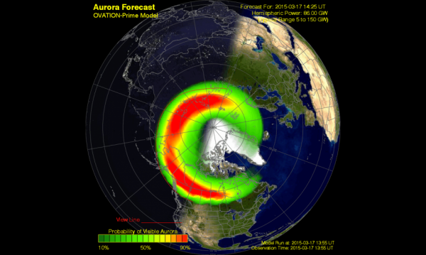
A G4 (Severe) geomagnetic storm was observed today at 07/1358 UTC (09:58 a.m. EDT). This is the response to a pair of CMEs observed leaving the Sun on March 15. Shown here is a model depiction of where the aurora is likely visible. Storm conditions are forecast to persist for the next several hours before beginning to wane down towards the end of the UT day. (Courtesy of NOAA)
A G4 (severe) geomagnetic storm is now taking place, the most powerful solar storm of the current solar cycle, reports Discovery.com.
Initially triggered by the impact of a coronal mass ejection (CME) hitting our planet’s magnetosphere, a relatively mild geomagnetic storm erupted at around 04:30 UT (12:30 a.m. EDT), but it has since become a severe G4-class geomagnetic storm. Bright auroras were sighted over several northern-tier U.S. states including Minnesota, Wisconsin, Montana, the Dakotas and Washington. The storm could continue for many hours as Earth passes through the turbulent wake of the CME.
Storm conditions are forecast to persist for the next several hours before beginning to wane down towards the end of the UT day.
Not all types of solar activity (sun spots, solar flares, solar burst, and solar radiation) affect GPS receiver operations. Geomagnetic storms, however, can cause problems for GPS receivers if the storms are powerful enough.
The solar cycle is about 11 years long, during which the sun waxes and wanes in magnetic activity.
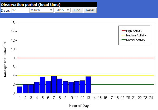
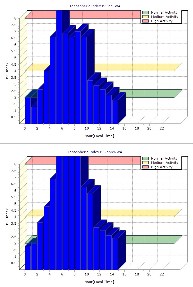
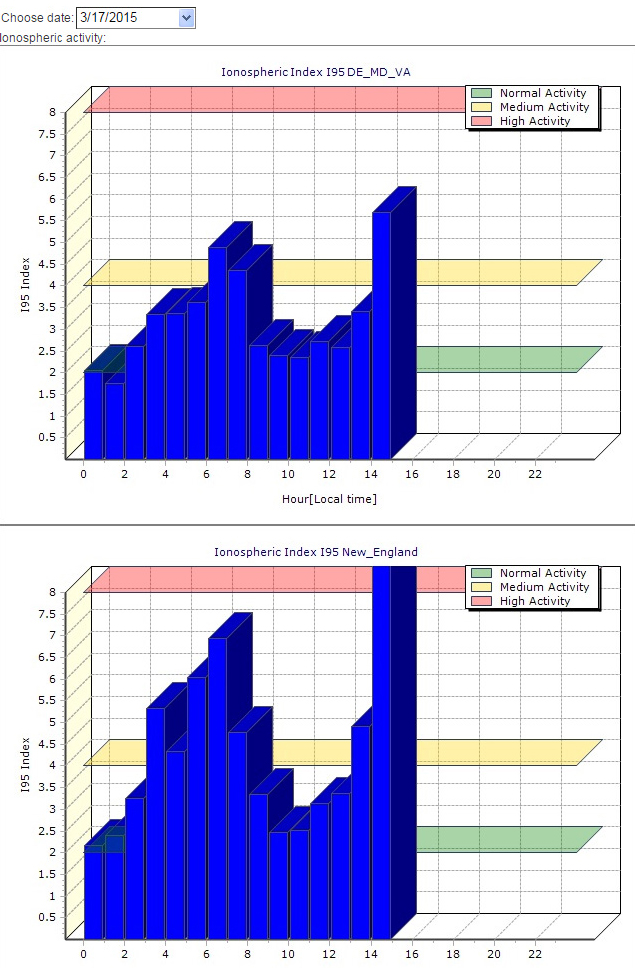
Below are ionospheric charts from Missouri, Washington State and New England.
Missouri ionosphere chart during the March 17 geomagnetic storm.Washington ionosphere chart during the March 17 geomagnetic storm.New England ionosphere chart during the March 17 geomagnetic storm.
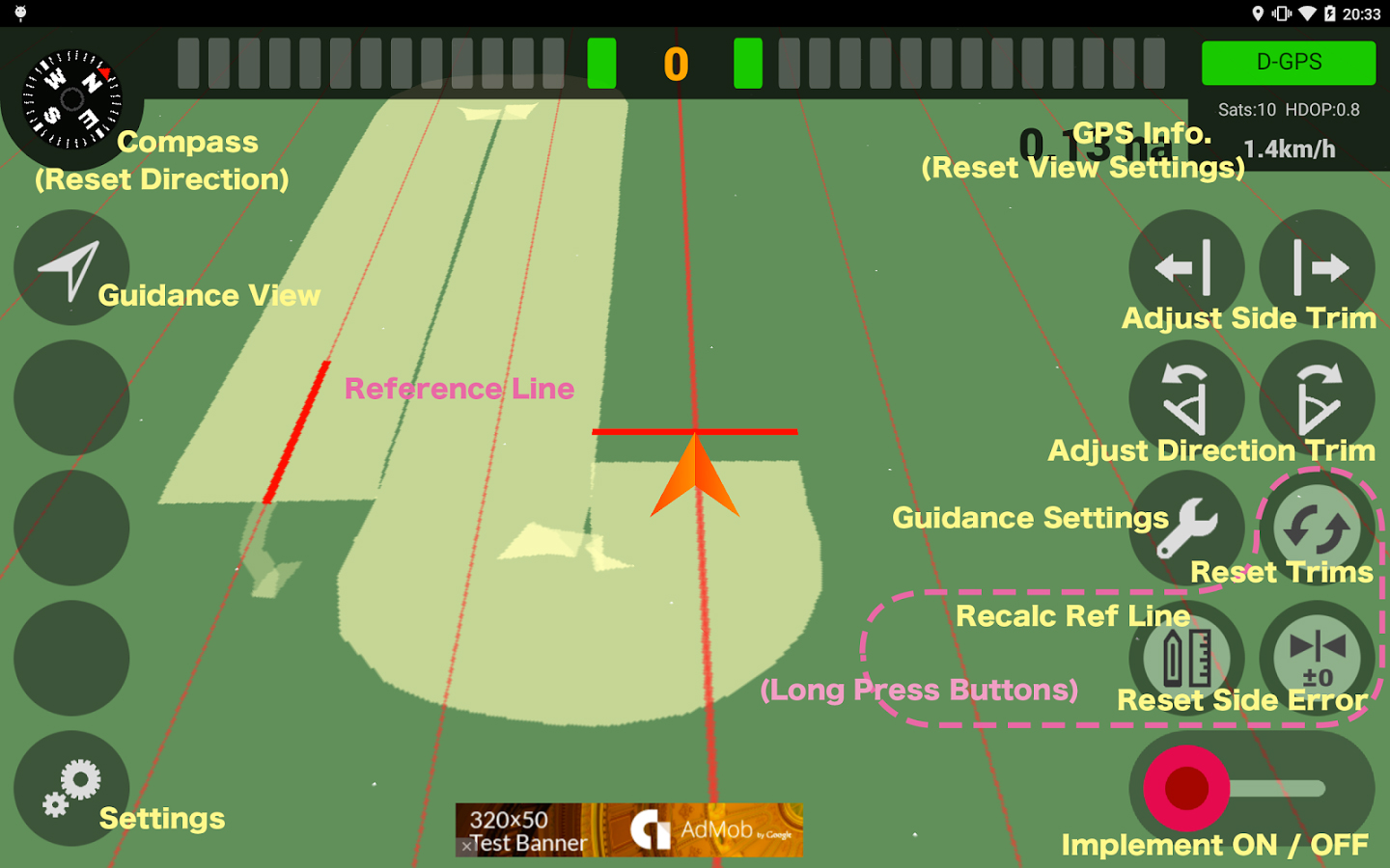
A new app available on the Google Play store enables farmers to use their smartphone in the field.
AgriBus-NAVI is a GPS guidance system to mount on agricultural machinery such as tractors, combines and self-propelled sprayers to help with straight-line tasks in the field. Checking the display while driving will enable the creation of straight and evenly spaced lines in large fields.
The app, which is compatible with Android 4.0 and above smartphones and tablets, doesn’t offer the automatic steering functionality that dedicated precision agriculture GPS devices usually do.
The app, by Agri Info Design, is based on the software “Agricultural Vehicle Navigation Software for Field Operation” and a patent “JP-4572417-B2” developed by National Agricultural Research Organization (NARO).
In the report, the analysts have identified and deciphered the market dynamics in important GNSS industry segments, highlighting the areas offering promising possibilities for companies to boost their growth, according to Research and Markets. The report studies the market by sectors including location-based services (LBS), transportation (further divided into road navigation, rail navigation, air navigation and marine navigation), surveying and agriculture. The GNSS application market is further studied by region: North America, Europe, Asia-Pacific, and Rest of World.
The report provides a complete overview of the GNSS market globally. All the current trends and drivers, coupled with potential growth areas of the GNSS industry, have been evaluated in the report. Furthermore, the report provides information on opportunities in the industry for different companies in the chapter titled Opportunity Assessment.
Additionally, to provide an exhaustive knowledge of the prospects for GNSS players on the geographical front, the report provides comprehensive knowledge of the 10 most worthwhile GNSS markets around the world (U.S., Canada, UK, France, Germany, Russia, Japan, China, South Korea and India). It includes information about the present state and future outlook of the LBS and telematics markets in these countries along with information about their personal navigation systems such as GPS, BeiDou,Galileo, GLONASS, QZSS and IRNSS.
The report also looks into the competitive landscape covering business overviews, key financials, product analyses, recent developments and strengths and weaknesses of each of the players.
Key trends considered in the report include:
Driverless Car: New GNSS Technology Use
Indoor GNSS Positioning Poised for Growth
People, Pets and Thing Finder: The Next Attraction
GNSS Based Products: A Burgeoning Market Opportunity
Trimble announced today a new version of its CenterPoint RTX correction service that delivers convergence to 4-centimeter horizontal accuracy in less than 5 minutes. The service is designed for a variety of precision agriculture operations in Central and Western Europe, and is available for use with the Trimble CFX-750 display.
Trimble CenterPoint RTX delivers highly accurate GNSS corrections via satellite without the need for traditional reference station RTK infrastructure, mobile data plans or additional on-machine hardware. The GNSS-enabled correction service delivers repeatable, real-time high-accuracy positions for land preparation, planting, harvesting and other high-precision farming applications.
Enabled by the new version of RTX technology, RTX version 5.0, the fast convergence time is the result of a new region-specific atmospheric model and a dense ground reference station network. Growers will realize an approximate 80 percent improvement in RTX convergence time as compared to the RTX-standard service that typically provides 30-minute convergence time, Trimble said.
Delivered via a new satellite broadcast covering western and central Europe, the new service will be available in Austria, Belgium, Czech Republic, France,Ireland, Germany, Luxembourg, the Netherlands, Western Poland, Southern Sweden and the United Kingdom.
“We are continually advancing our Trimble RTX technology to improve productivity in the field,” said Patricia Boothe, general manager of Trimble Positioning Services. “Faster initialization times allow growers to start working more quickly, freeing up time to focus on other farm operations. No other satellite-delivered correction service today can offer better than 4 centimeter accuracy in less than 5 minutes.”