NovAtel has announced significant performance improvements to its precise point positioning (PPP) solution. NovAtel CORRECT with PPP will now offer the new TerraStar-C correction service as its exclusive source for satellite-delivered PPP correction data.
TerraStar-C contains an enhanced correction data set that enables up to 4-centimeter accuracy and instant re-convergence when combined with the receiver error models and positioning algorithms offered by NovAtel CORRECT. This new level of PPP performance is available on NovAtel’s OEM6 receivers with firmware version 6.600.
NovAtel CORRECT is the positioning algorithm on NovAtel’s GNSS receivers that handles corrections from a variety of sources, including real-time kinematic (RTK), PPP, spaced-based augmentation systems (SBAS) and differential GPS (DGPS). NovAtel CORRECT with PPP combines GNSS satellite clock and orbit correction data from TerraStar’s global reference station network with NovAtel’s receiver algorithms to yield robust sub-decimeter positioning without the need for nearby base stations.
Correction data provided by TerraStar is delivered to the end user via Inmarsat satellites. With satellites visible globally, PPP is an ideal solution for precision applications where communications infrastructure is either unreliable or not available. In addition, applications where signal interruptions are common will benefit from a more robust positioning solution with the ability to quickly regain full accuracy following a temporary loss of GNSS signals, NovAtel said.
NovAtel customers with current TerraStar-D subscriptions have the option to upgrade to the new TerraStar-C service level free of charge. The new NovAtel PPP performance level is available immediately.
Veripos, a supplier of high-precision GNSS positioning facilities to offshore and associated industries, has upgraded its Apex and Apex² precise point positioning (PPP) services.
The services now typically provide users with a horizontal position accuracy of better than 5 cm and 12 cm in the vertical at the two sigma (95 percent) confidence level.
The enhanced levels of performance, now available to all current users of Apex and Apex² without any need to upgrade, have been calculated from static data obtained in Aberdeen, Scotland, where Veripos is headquartered, as well as Houston, Texas, and Singapore. Veripos said that accuracies may vary with observing conditions, however.
The improved accuracy follows a major upgrade of the entire Veripos global reference station network for tracking all GNSS signals, together with introduction of new receivers and geodetic antennas for delivery of better measurement quality resulting from refinements to algorithms and software used to derive necessary GNSS orbit and clock corrections.
Designed to meet all offshore positioning and navigation applications, the dual-beam Apex and Apex² PPP services are relayed via seven geostationary communications satellites to ensure continuous availability and service redundancy while providing access to both GPS and GLONASS constellations. Positional accuracy is maintained regardless of user location, Veripos said.
Editor’s Note: Alan Cameron is editor-in-chief and publisher of GPS World magazine. He also writes the monthly GNSS Design & Test newsletter. The views expressed are his own.
“It’s tough to make predictions, especially about the future.” This insight comes from the 20th-century American sage Yogi Berra. Yet predictions — hedged guesses, if you will — form the basis of nearly all new business ventures and decisions in ongoing business activities.
For surveyors in the year 2015, one of the key predictions — or guesses — to make concerns the next GNSS to come predictably and reliably online, to augment GPS where GPS alone does not fully function: under canopy, in dense urban environments, and so on. More satellites visible at more varied angles in the sky can help surmount these obstructions.
Staking the future of one’s business, in the form of new equipment acquisition, in such an environment is a bit like betting on a long-distance horse race. First one steed surges to the head of the pack, then it falls back as another charges forward. We have seen this pattern repeatedly in the growth of GLONASS, Galileo and BeiDou.
Some may say that GLONASS, the Russian system, has already won the race (the first heat, at least) and currently fills the role of GPS partner in precision surveying. It does, to some extent, but its future viability is cloudy — and its past record is patchy, to say the least. It rose to full operational capability around the turn of the century, then fell very, very low in numbers as short-lived satellites expired and were not replaced at sufficient rate. Recently, GLONASS has mounted a resurgence, but that has been marred by repeated launch failures and a disturbing anomaly. It cannot be counted or confirmed a winner, yet.
I spoke yesterday with an expert and veteran professional land surveyor who expressed the opinion that the manner in which surveying is conducted will change more in the next five years than it has in the last 25. Keep in mind that the last 25 years saw enormous changes themselves, as GPS significantly transformed, upgraded and made vastly more efficient most surveying activities.
Betting on a horse race in such a rapidly changing environment becomes even more chancy.
Here’s a tip from a racetrack tout: don’t count Galileo out.
GLONASS we recounted briefly above. BeiDou recently achieved a regional operations status over Eastern Asia, but further developments there have been puzzlingly quiet for some time.
The European system has come on with agonizing slowness since the year 2000, suffering many delays and most recently what could have been a debilitating failed dual launch. But the combined strength of the European Union continues to push determinedly forward, and the program has an ambitious schedule with an eye firmly fixed on operability. And some recent research results tend — perhaps — to substantiate the claim, long pooh-poohed by those in the United States, at least, that Galileo will eventually prove “better” than GPS. Details further on.
What might a prudent yet pragmatic, forward-looking surveying firm do in this uncertain environment, where the only certainty is change, and likely to be rapid change at that? Here’s another racetrack tip: don’t make any big bets just yet, but study the field closely and continuously. In particular, watch Galileo’s performance.
A further item to be checked in Galileo’s favor: its system operators have long been in close talks with the U.S. government on many matters involving co-operation and interoperability. As recounted in a recent story concerning the Federal Communications Commission’s surprising role in this matter, the Europeans are filling out the proper forms for full accreditation within the United States. This could turn out to be important in business operations.
Back to studying the field closely: also study leading manufacturers’ offerings in this regard. They also are making bets on the future; quite possibly they have better information, and/or have done more extensive analysis of what information is available, paired with in-depth, highly technical research and development of signal characteristics and how signals from disparate GNSS can be most productively combined.
A quick scan of GPS World’s2015 GNSS Receiver Survey shows the following key manufacturers (among others) have GPS receivers now commercially available that are Galileo-ready: Altus Positioning Systems, Ashtech, Geneq, iFEN, JAVAD GNSS, Leica Geosystems, NovAtel, NVS Technologies, Septentrio, Sprecta Precision, Spectrum, Topcon, and Trimble.
Better than GPS???
Supporters of Galileo have long raised hackles west of the Atlantic with claims that Galileo would provide better accuracy than GPS. Not! cried the faithful, and especially not when the modernized and improved, strengthened, more accurate GPS III signals are coming along just as fast if not faster than Galileo. Recently the pace of GPS III has come into question; can the Gold Standard and clear leader for 25+ years really be falling back into the pack?
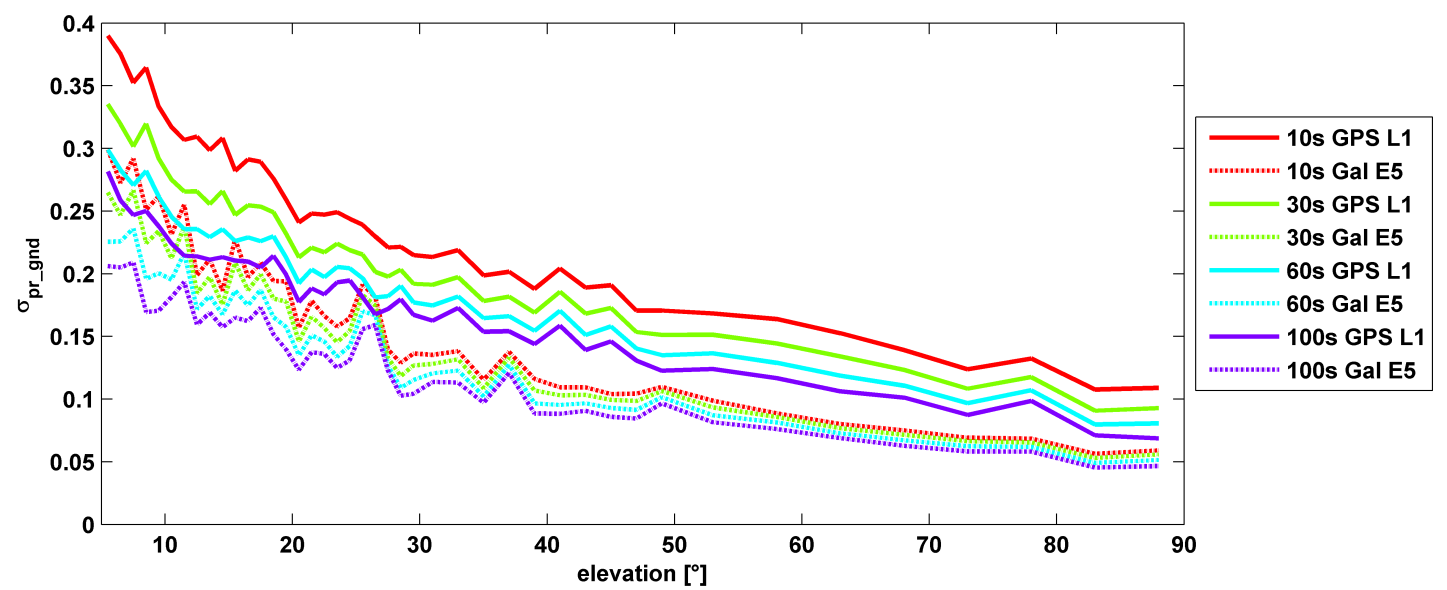
σ(pr_gnd) versus elevation for Galileo E1 (dotted lines) and GPS L1 (solid lines for different smoothing constants: red (10s), green (30s), cyan (60s), purple (100s).
Let’s disregard that question for the time being, and look at some recent research, to be reported in full in the cover story of GPS World magazine’s April issue, out soon. In it, the authors (two German and one American researcher) report:
“Analysis of new Galileo signals at an experimental ground-based augmentation system (GBAS) compares noise and multipath in their performance to GPS L1 and L5. Raw noise and multipath level of the Galileo signals is shown to be smaller than those of GPS. Even after smoothing, Galileo signals perform somewhat better than GPS and are less sensitive to the smoothing time constant.”
This is all pretty arcane and a bit removed from current field of operations, as far as surveyors are concerned. But it does signal something, and it provides food for thought.
The researchers obtained their results using four JAVAD Delta receivers, all connected to Leica AR 25 choke ring antennas.
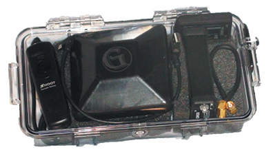
Geomatics USA from Gainesville, Fla., has designed a precision surveying and mapping system that can be easily stowed in an overhead compartment for airline travel. Surveyors can fit everything needed for important mapping and surveying jobs into a baseball-style bag, including tripods. The compact, light-weight system offers differential sub-foot accuracy.
Components easily pack into a baseball-style case.
The G1-m1 receiver system has many advantages over conventional GNSS receivers, Geomatics said. The system is designed for precision surveying jobs that require travel to remote areas of the world, and for traveling to job sites by commercial airline. The complete base and rover kit, including the tripods, rods, and batteries, fits into a single baseball style bag and weigh less than 10 kg, making it easy to stow as carry-on luggage.
The Geomatics USA G1 system is scalable from a simple single-frequency semi-mobile receiver — ideal for control networks and some semi-kinematic mapping applications — to a dual-frequency network RTK solution. All of the Geomatics USA G1 solutions perform precision-quality tasks at a fraction of the cost of major-brand equipment.
The G1-m1 system comes with a free processing software license for the first 50 systems that supports carrier-phase relative positioning and CA-code differential correction. The software is designed with a simple user interface for easy selection of base and rover data or automatic data download of the closest Continuously Operating Reference Station (CORS) from the U.S. National Geodetic Survey database. It is compatible with other RINEX based post-process systems around the world.
Complete survey set including GNSS receiver, antenna, battery and cables, fits in a small handheld plastic case.
According to Geomatics USA Chief Technology Officer Ahmed Mohamed, “The G1 product line fills the gap between survey applications, where cm-level precision is an absolute necessity, and mapping applications, where meter-level precision is acceptable. In fact, the G1-m1 product offers sub-foot precision in most cases and cm-level precision in ideal situations. Geomatics USA uses readily available components and open-source code to develop its end user product solutions. The objective is to make sure the software performs correctly with a very short learning curve for the user.”
For a limited time, Geomatics is offering a specially priced configuration for the first 50 systems through NavtechGPS, its worldwide distributor.
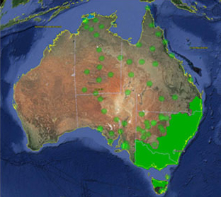
Trimble VRS Now coverage in Australia. Photo: Trimble
Trimble, together with its distribution partner Ultimate Positioning Group, announced the availability of Trimble VRS Now correction service in Queensland, New South Wales, South Australia, Tasmania and Victoria.
Trimble is also now offering the Trimble VRS Now correction service in Oregon’s Willamette Valley.
The commercial subscription service provides surveyors, civil engineers, geospatial professionals and other industry specialists in these areas with instant access to real-time kinematic (RTK) GNSS corrections without the need for a base station.
Using both GPS and GLONASS constellations, the Trimble service delivers centimeter-level RTK corrections customized for each GNSS receiver’s location anywhere in the network via cellular communications. The Trimble VRS Now service supplies accurate, reliable and easy-to-use GNSS positioning for a variety of applications including surveying, urban planning, urban and rural construction, environmental monitoring, resource and territory management, disaster prevention and relief and scientific research, Trimble said.
“The addition of VRS Now to Trimble’s current portfolio of corrections technologies and services in Australia highlights our ability to meet any accuracy, delivery, availability and financial consideration across a variety of applications and markets,” said John Sprivulis, business area director of Trimble’s Positioning Services Division in the Asia Pacific. “Trimble is effectively creating a national positioning infrastructure to meet Australia’s future needs.”
Trimble VRS Now in Australia is a continuation of Trimble’s focus on providing solutions that enable customers to increase productivity by simplifying access to high-precision accuracy around the world. Similar VRS Now services are operating in parts of the U.S. and Europe.
In addition, the Australian VRS Now service supports the Trimble Pivot Field Mobile App, which provides up-to-the-minute information on the VRS Now system status for users in the region.
Because OmniSTAR CORS service in the area is being phased out, existing Australian users will be automatically transitioned to the Trimble VRS Now service, which provides easy access to high accuracy and reliable positioning within the network coverage area.
Service in Australia and Oregon is a continuation of Trimble’s focus on providing solutions that enable customers to increase productivity by simplifying access to high-precision positioning around the world. Similar VRS Now services are operating in Illinois, Indiana, Iowa, Nebraska, Colorado, Florida, Alabama, Mississippi, Texas, and parts of Europe.
Components easily pack into a baseball-style case. Photo: Nicholas DiGruttolo
By Nicholas DiGruttolo
When asked to do a small survey job overseas, we were concerned about shipping bulky and expensive survey equipment. Shipping costs are not trivial. Add to that the real possibility that your survey equipment may be confiscated by the local authorities, as ours was in Djibouti, and the cost of shipping equipment becomes a substantial part of the overall job. There should be alternatives, especially if accuracy requirements are not stringent.
Faced with this problem for a second time, we considered a new receiver system that has many advantages over conventional survey-grade GNSS receivers: It is small, lightweight and low-cost without sacrificing performance, making it ideal for precision surveying in remote areas of the world and for traveling to the job site by commercial airline. All the components, including the tripods, rods and batteries, are constructed from commercial off-the-shelf (COTS) components. A complete base and rover kit fits in a baseball bag and weighs less than 10 kilograms. The kit is sized and approved as carry-on luggage.
The system is scalable from a simple single-frequency semi-mobile receiver for control networks and some semi-kinematic mapping applications, to a dual-frequency network RTK solution.
The system comes with free processing software that supports carrier-phase relative positioning in real time and post mission, as well as precise-point positioning (PPP) and CA-code differential correction. The software is designed with a simple user interface for easy selection of base and rover data or automatic data download of the closest Continuously Operating Reference Station (CORS) from the U.S. National Geodetic Survey database.
Complete survey set including GNSS receiver, antenna, battery and cables, fits in a small handheld plastic case. Photo: Nicholas DiGruttolo
The system fills a gap between survey applications, where centimeter-level precision is an absolute necessity, and mapping applications, where meter-level is tolerable. The product offers sub-foot precision in most cases and centimeter precision in ideal situations.
Our team recently performed topographic mapping of an oil refinery site in Saudi Arabia and surveyed a precise-elevation network in Sarasota, Fla., to research the effects of sea-level rise. The small size of the COTS components simplified transport to Saudi Arabia, eliminating additional airline baggage fees and easing import through customs. Researchers performing the sea-level study reduced field time by increasing the number of receivers needed to observe a robust vertical control network.
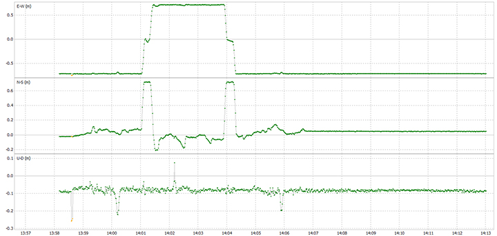
Oil Refinery. The oil refinery project entailed mounting a GNSS antenna on the roof of an off-road vehicle and driving multiple transects around the 18-kilometer perimeter of the site to record the elevation of the terrain. Kinematic data was recorded at 1 Hz using a GPS-only version of the single-frequency receiver. Baseline length to the local reference station varied from less than 1 kilometer to about 10 kilometers. The site was open desert with no overhead obstructions or sources of multipath other than the roof of the vehicle on which the antenna was mounted. Post-processing and comparison to simultaneously collected data from a high-precision survey-grade receiver revealed positional accuracy of about 5 centimeters horizontal and 10 centimeters vertical, when the system’s trajectory was compared to the truth trajectory provided by the survey-grade receiver. Figure 1 shows the difference between the two trajectories. The system’s antenna was 2 feet away from the survey-grade antenna along the driving direction of the vehicle; the trajectory was mostly in the north-south direction and hence the 0.6-m offset in the plot!
Figure 1. Antenna location difference in the sub-decimeter range between the survey-grade system and the compact low-cost system. Note: A 0.6-m offset is to be removed from the difference, as the two antennas were mounted 0.6 m apart in the vehicle driving direction.
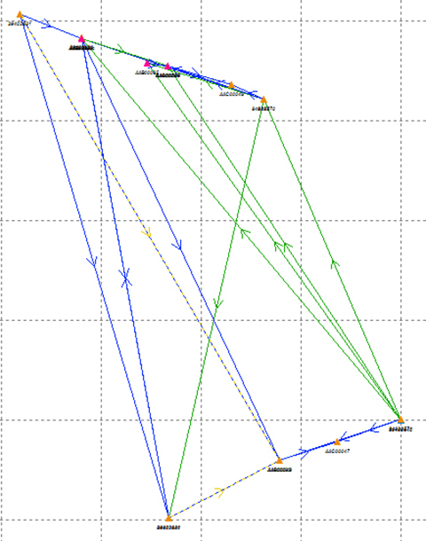
Sea Level. The sea-level-rise study required a high-accuracy vertical control network to cover a 2,500 hectare area. The purpose of the network is to determine the shortest term effects of sea-level rise with a rate of 1.8 millimeter/year in the affected area. Ten benchmarks were established throughout the area of interest, and a robust network of static observations was performed with a combination of two dual-frequency and two single-frequency receivers. The single-frequency receivers were GPS-only units where two standard 4-inch patch antennas were mounted on rods adjusted to a 0.9-meter height. The addition of two receivers provided greater redundancy and a stronger network solution in much less time than would have been possible with only one pair of survey-grade receivers. Figure 2 shows the addition of several loop ties to the network as a result of adding the two roving, lightweight receivers.
Figure 2. Sea-level rise monitoring network showing increased tie points and redundancy as a result of adding the extra lightweight precision receivers to the survey-grade receivers.
Nicholas DiGruttolo works as a field surveying manager for JBrown Professional Group Inc., Northrop Grumman Corporation, and has recently become vice president of surveying.
SPAR International is a platform-neutral conference and exhibition focused on end-to-end business and technology for 3D measurement and imaging for industrial facilities; engineering, architecture and construction; and civil infrastructure. The exhibition will showcase solutions from leading 3D hardware manufacturers, software suppliers and service providers.
The conference and trade show will be held March 30-April 2 in Houston, Texas.
Watch a video about the conference:
At SPAR International, current and emerging 3D technology and lifecycle asset-management solutions will be highlighted. More than 90 experts in 3D data, point-cloud processing, and data delivery will explain how to improve processes, mitigate risk, get the necessary output, and save time and money.
This year SPAR features a dedicated UAV pavilion, where attendees can learn about the market and discuss solutions with major manufacturers. It also features a hologram room — a taste of the future that puts you inside a 3D scan.
On the exhibit floor, developers and manufacturers will showcase the latest solutions developed to solve pressing and complex problems in a range of industries. 3D scanners, low-cost handheld devices, mobile mapping solutions, advanced data processing workflows, and more will be featured.
Learning levels for 2015 include:
Business Consideration: Critical topics for asset owners and business leads.
3D Technologies and Applications: In-depth content for 3D pros.
Introduction to 3D Tools: Basics for beginners and those new to 3D.
Other topics covered include:
Building Information Modeling (BIM)
3D for asset and facilities management
3D data capture for as-built conditions
Point-cloud processing
Managing and sharing large data sets
3D/intelligent modeling
Augmented reality and visualization tools
UAVs/UAS
Numerous networking events provide opportunities to gain valuable information from other precision-measurement and imaging professionals across disciplinary lines. Attendees can discuss best practices, share project experience, and benefit from the experiences of their peers.
Fugro has launched the G4 service, designed to provide GNSS augmentation for offshore positioning applications. The new satellite correction service takes advantage of all four GNSS: GPS, GLONASS, BeiDou and Galileo.
By using all available GNSS satellites, Fugro’s G4 service is designed to improve availability and reliability of offshore positioning and thus enhance the safety and productivity of a wide range of survey and other activities offshore. G4 represents a significant advancement compared to augmentation systems which are based on GPS-only or GPS + GLONASS, the company said.
The BeiDou system operated by China currently provides coverage in the Asia-Pacific region. Fugro’s G4 service already utilises the first BeiDou satellites and is ready to start using the Galileo satellites as soon the EU announces Initial Operational Capability (IOC) status for this system. Galileo and future BeiDou satellites will be automatically included as they come online, steadily increasing availability and robustness of the integrated augmentation service.
The new G4 service will be particularly beneficial when the line-of-sight to certain satellites is obstructed by offshore structures – a key consideration during critical positioning operations. The G4 augmentation signals, transmitted via seven high–powered communication satellites to provide at least two independent broadcast channels anywhere in the world, will offer Fugro’s customers unrivalled coverage and availability.
Trimble has introduced the R1 GNSS receiver, a pocket-sized, rugged, standalone receiver that works with iOS, Android or Window mobile handhelds, smartphones and tablets using Bluetoothconnectivity. When paired with a smart device, the receiver adds professional-grade GNSS geo-location capabilities to transform consumer devices into high-accuracy mobile data collection systems.
With the evolution of smartphones and tablets, more field workers now have access to positioning technologies for geospatial data collection. The Trimble R1 GNSS receiver is designed to collect data and inspect or manage assets using smart devices without an integrated high-accuracy GNSS receiver. Adding the optional Trimble ViewPoint RTX correction service to the R1 receiver enables users to achieve reliable sub-meter accuracy, Trimble said.
The Trimble R1 receiver is compact and portable, weighing 6.5 ounces (187 grams). With an all-day battery life, the receiver can be carried in a vest pocket, attached to a belt using the optional belt pouch, or pole mounted. The receiver also integrates with Trimble TerraFlex, Trimble TerraSync and Trimble Positions mapping and Geographic Information System (GIS) field software.
“The addition of the R1 GNSS receiver expands our portfolio to address the needs of organizations that have adopted a workplace Bring Your Own Device (BYOD) strategy for their businesses. We are providing an innovative solution to enable next generation capabilities for a much broader base of field workers to collect high-accuracy geospatial data,” said Alain Samaha, business area director of GIS and Software for Trimble’s Geospatial Division. “Our focus is to provide customers with a variety of options and flexibility when it comes to mobile device deployment and authoritative data collection to increase productivity and improve operations.”
The Trimble R1 GNSS is a multi-constellation receiver that supports GPS, GLONASS, Galileo, BeiDou and QZSS satellite signals. The Trimble ViewPoint RTX corrections are delivered via cellular data network coverage or over satellite in remote locations — without the need for a traditional base station or VRS network — when using Trimble’s Mapping & GIS software or API. In addition, the R1 receiver can leverage SBAS and VRS correction sources to achieve sub-meter accuracy.
Trimble TerraFlex is a scalable cloud-based solution for geospatial data collection. TerraFlex addresses a wide variety of field requirements including attribute-rich GIS data collection on professional and consumer devices.
DigPilot, a Norwegian supplier of surveying equipment and instruments for building and construction, has developed a flexible 3D machine guidance system based on Septentrio’sAsteRx2eH OEM GNSS receivers.
AsteRx2eH is a single-board dual-frequency dual-antenna 272-channel GPS/GLONASS OEM heading receiver, which provides 20-Hz data output of position, heading and pitch/roll data to the machine guidance system. As a member of Septentrio’s AsteRx family of compact OEM boards, the AsteRx2eH receiver is built around the same advanced GNSS chipset and shares the family’s all-in-view GPS and GLONASS tracking and advanced signal processing algorithms for robust tracking and high-precision positioning, even in challenging environments.
The DigPilot machine guidance system uses wireless technology for all of the installed sensors, instead of being hard-wired into the machine. All the components come packed in a hardened plastic case for transportation from one machine to another. The sensors can be clipped into brackets on the excavator arm and cab and calibrated to the machine and bucket in a matter of minutes, Septentrio said. The operator uses an intuitive graphics display on a rugged touchscreen console to control the arm and shovel following a preloaded grade plan.
The DigPilot machine guidance systems have been documented to improve on-the-job safety, productivity and quality of work while reducing costs dramatically. With the DigPilot system, companies can move the 3D guidance system around the fleet of construction equipment as needed, at a fraction of the cost of installing hard-wired systems on multiple machines, Septentrio said.
DigPilot customers are also using APS-3 GNSS RTK receivers from Altus Positioning Systems, a Septentrio company, in conjunction with the on-board machine guidance system for high-precision site surveys and as-builts.
“With the Septentrio OEM receivers we know we can count on the highest levels of accuracy, reliability, ruggedness and performance,” said Jan Floberg, CEO and founder of DigPilot. “We tested all other available GNSS products on the market before deciding on Septentrio. The AsteRx2eH outperforms the other brands in its ability to obtain and hold fix and heading in the rugged terrain of western Norway. We have deployed over 1,000 systems to date.”
Altus and Septentrio products will be on display at World of Concrete in Outdoor Booth 032025 at the Las Vegas Convention Center, Feb. 3-6.
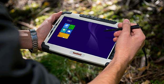
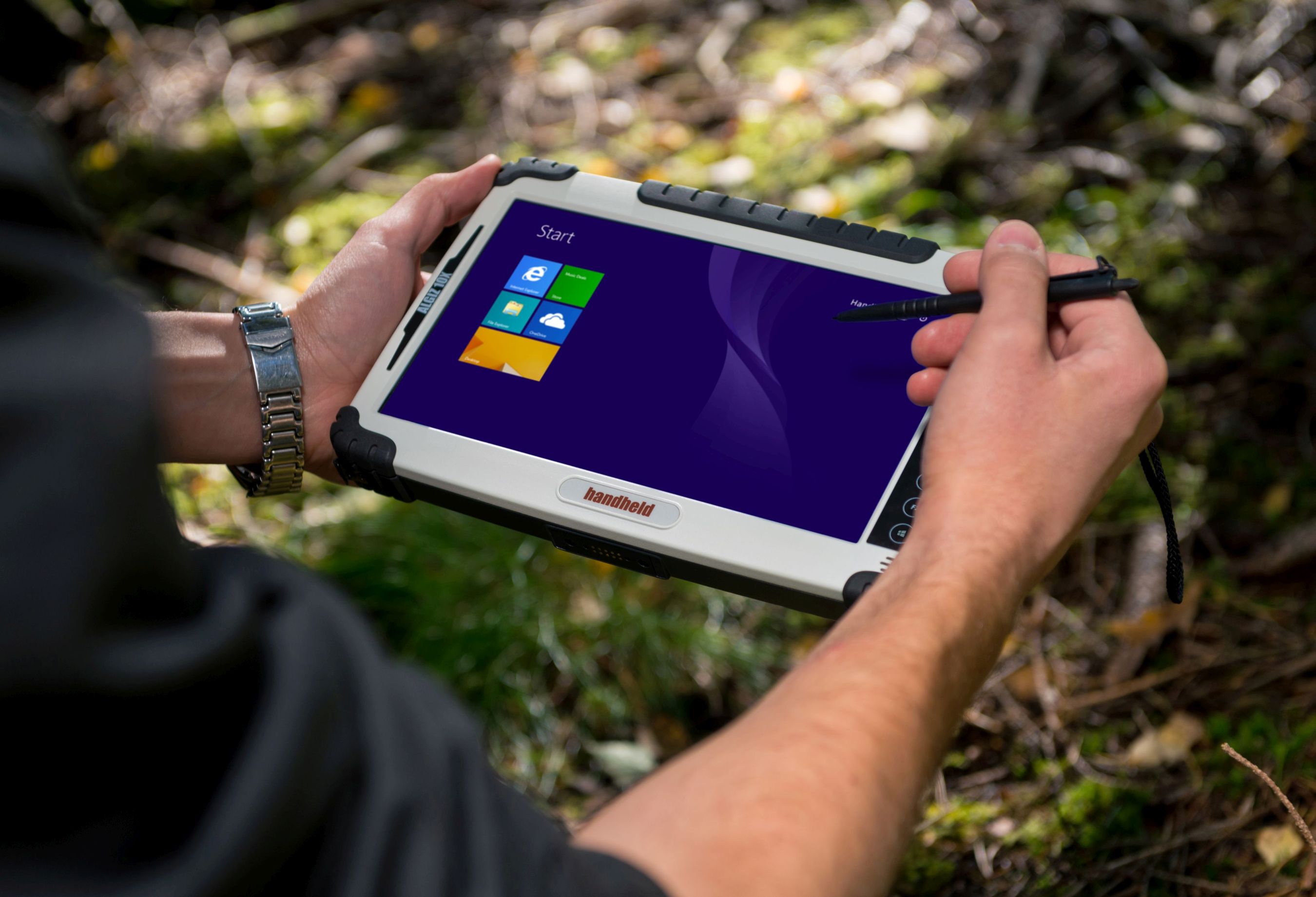
Handheld’s Algiz 10X rugged tablet now has Windows 8, a faster processor.
Handheld Group is upgrading its Algiz 10X tablet. With the upgrade, the rugged tablet for field professionals now features the Windows 8.1 Pro operating system, which is downgradable to Windows 7. Windows 8.1 Pro offers enhanced features to help users connect to company networks, access one PC from another, encrypt data and more.
The upgraded Algiz 10X also has a more powerful processor that speeds startup and operation, increases software compatibility and doubles processor performance. Its has an integrated u-blox GPS receiver with WAAS/EGNOS/MSAS capability.
Like all of Handheld’s rugged PDAs, smartphones and mobile computers, the Algiz 10X is specifically developed for field workers in industries such as geomatics, logistics, forestry, public transportation, utilities, construction, maintenance, mining, military and security. It is IP65-rated and meets stringent MIL-STD-810G military standards — protected against dust, water, vibrations, drops and extreme temperatures. It has a 10.1-inch touchscreen, weighs 1.3 kilograms (2.9 pounds) and is 32 millimeters (1.2 inches) thick.
“By using the very latest operating system available from Microsoft, customers can now enjoy quicker startup and operation, increased software compatibility and improved support for touchscreen-based tablets, among other benefits,” said Johan Hed, Handheld’s director of product management.
The new Algiz 10X also has the powerful Intel quad-core N2930 1.83 GHz processor with 2.16 GHz boost. This processor allows for both higher performance and cooler running temperatures. Compared to the Algiz 10X’s previous processor, the N2930 more than doubles performance benchmarking, RAM support, number of cores and performance per watt.
“We have dramatically increased performance levels without sacrificing operating time or mechanical design,” Hed concludes. “We have also improved our wireless communication support. Besides 802.11 b/g/n on 2.4 GHz, we now support both 802.11ac and 802.11a on 5 GHz. The upgraded Algiz 10X also supports LTE, which provides substantially faster data speeds, both up- and downstream, and increased overall network coverage.”
Key features of the Algiz 10X version 2:
Powerful Intel quad-core N2930 1.83 GHz processor
128 GB SSD, expandable via microSD
4 GB of DDR3 RAM
Windows 8.1 Industry Pro (downgradeable to Windows 7)
10.1-inch touchscreen with high-brightness MaxView screen technology
IP65 rating and conformity to stringent MIL-STD-810G test standards
LTE capability with a fully integrated modem and antennas
Integrated u-blox GPS receiver and WAAS/EGNOS/MSAS capability
Antenna pass-through connectors for both GSM and GPS
Several connectivity options, including WLAN and BT, USB 2.0 and USB 3.0, VGA and RS232 ports
The upgraded Algiz 10X is available now and orders can be placed immediately.
You may have heard about “NMEA data” with respect to GPS.
NMEA is an acronym for the National Marine Electronics Association. NMEA existed well before GPS was invented. According to the NMEA website, the association was formed in 1957 by a group of electronic dealers to create better communications with manufacturers. Today in the world of GPS, NMEA is a standard data format supported by all GPS manufacturers, much like ASCII is the standard for digital computer characters in the computer world.
The purpose of NMEA is to give equipment users the ability to mix and match hardware and software. NMEA-formatted GPS data also makes life easier for software developers to write software for a wide variety of GPS receivers instead of having to write a custom interface for each GPS receiver. For example, VisualGPS software (free), accepts NMEA-formatted data from any GPS receiver and graphically displays it. Without a standard such as NMEA, it would be time-consuming and expensive to write and maintain such software.
What makes NMEA a bit confusing is that there are quite a few “NMEA” messages, not just one. So, just like there are all kinds of GPS receivers with different capabilities, there are many different types of NMEA messages with different capabilities. Furthermore, NMEA data can be transmitted via different types of communications interfaces such as RS-232, USB, Bluetooth, Wi-Fi, UHF and many others.
NMEA Message Structure
To understand the NMEA message structure, let’s examine the popular $GPGGA message. This particular message was output from an RTK GPS receiver:
13 denotes number of satellites used in the coordinate
1.0 denotes the HDOP (horizontal dilution of precision)
495.144 denotes altitude of the antenna
M denotes units of altitude (eg. meters or feet)
29.200 denotes the geoidal separation (subtract this from the altitude of the antenna to arrive at the Height Above Ellipsoid (HAE).
M denotes the units used by the geoidal separation
1.0 denotes the age of the correction (if any)
0000 denotes the correction station ID (if any)
*40 denotes the checksum
The $GPGGA is a basic GPS NMEA message. There are alternative and companion NMEA messages that provide similar or additional information.
Here are a couple of popular NMEA messages similar to the $GPGGA message with GPS coordinates in them (these can possibly be used as an alternative to the $GPGGA message):
In addition to NMEA messages that contain a GPS coordinate, several companion NMEA messages offer additional information besides the GPS coordinate. Following are some of the common ones:
$GPGSA – Detailed GPS DOP and detailed satellite tracking information (eg. individual satellite numbers). $GNGSA for GNSS receivers.
$GPGSV – Detailed GPS satellite information such as azimuth and elevation of each satellite being tracked. $GNGSV for GNSS receivers.
$GPGST – Estimated horizontal and vertical precision. $GNGST for GNSS receivers.
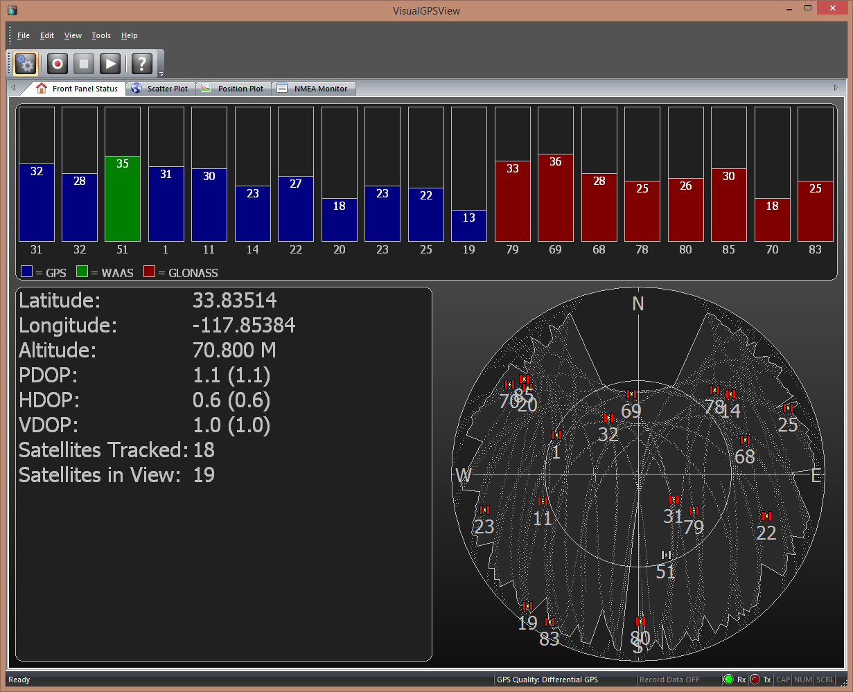
Rarely does the $GPGGA message have enough information by itself. For example, the following screen requires: $GPGGA, $GPGSA, $GPGSV.
VisualGPSView screenshot. (Photo: VisualGPC LLC)
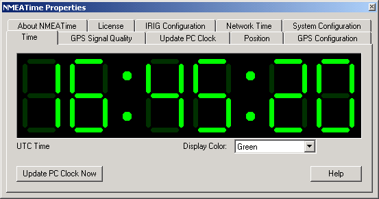
The following screen, focused on the time capabilities of GPS, requires a slightly different set of NMEA messages: $GPGGA or $GPRMC or $GPZDA, $GPGSA, $GPGSV.
NMEATime. (Photo: VisualGPC LLC)
The above screenshot examples are useful for the general GPS user. The $GPGST message is particularly useful for high-precision GPS mapping and surveying. In fact, I would say it’s a requirement for high-precision users. The reason is that GPS metadata is very important for the high-precision user as a method of assisting in determining the quality of a particular GPS coordinate. Typical GPS real-time metadata used in understanding the quality of the GPS coordinate include: PDOP, number of satellites tracked, correction method and horizontal/vertical standard deviation values. If a GPS receiver user has the ability to see this information in the field during data collection, they have a level of confidence in the precision of the GPS data they are collecting. If you’ve used RTK before, you probably recall the familiar horizontal RMS (HRMS) and vertical RMS (VRMS) values displayed on your data collection device. The $GPGST message generates those values.
DD.MMMMMMM, DDMM.MMMMM, or DDMMSS.SSSSS
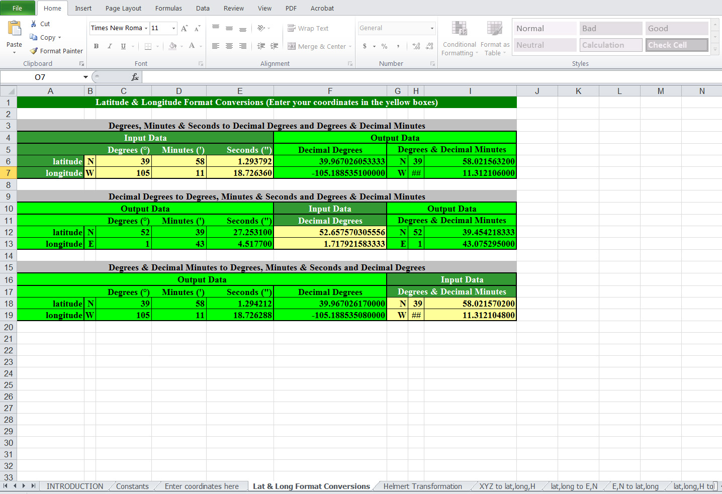
One of the challenges in dealing with raw NMEA data (data not using a software like VisualGPS to decode it for you) is the format of the GPS coordinate. It’s not user-friendly. It’s expressed in DDMM.MMMMM; degrees, minutes and decimal minutes. To display the coordinate in a different format, there’s a useful Excel spreadsheet published by the UK Ordnance Survey.
UK Ordnance Survey Coordinate Calculator
To use the spreadsheet, simply enter the GPS coordinate in the format you have, and the spreadsheet will calculate and display the GPS coordinate in the other two formats.
Click here to download the UK Ordnance Survey Excel spreadsheet coordinate calculator.