Category: Survey

  • Satlab Launches SL600 on-the-Pole Survey Receiver

    Satlab Launches SL600 on-the-Pole Survey Receiver

    The SatLab SL600 GNSS survey receiver.
    The SatLab SL600 GNSS survey receiver. Photo: SatLab Geosolutions AB

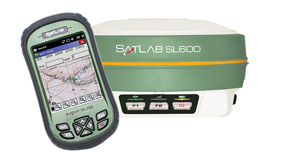
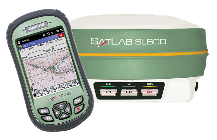
    SatLab Geosolutions AB is now shipping its new SL600 on-the-pole GNSS survey receiver.

    SatLab announced the unit earlier this year as the replacement of its SL500 on-the-pole surveying receiver. After a summer of testing and a premiere showing at InterGeo 2014, held in Berlin in October, SatLab is ready to ship the SL600 to its dealer network and customers.

    The new receiver is designed to meet the evolving needs of the surveying market, and is designed for general land, marine and construction applications. At the heart of the rugged unit is a 6G GNSS receiver capable of using all six GNSS satellite networks (GPS, GLONASS, BeiDou, Galileo, QZSS and SBAS), providing reliable operation in demanding conditions, SatLab said.

    The SL600 is lightweight at 1.2 kg. Its Xenoy housing holds up well to real-world use, according to test results by SatLab, resistant to 3-meter drops and 2 meters of water submersion. The dual hot swappable batteries provide 18-24 hours of continuous field use, depending on the mode of operation.

    The SL600 receiver has a new onboard computer running the LINUX operating system, which ensures easy implementation of new functionalities, often a result of customer-specific requirements. Over time, over-the-air firmware updates will be automatically available, adding new features at no additional charge. Users will be notified by the unit to accept the new firmware updates, or refuse them if they wish to keep their units as is.

    The SL600 system is available with various communication capabilities. Cellular 3G and Bluetooth as well USB and RS232 connectivity are standard, and an optional internal 2W Pacific Crest XDL radio is also available. Voice notifications notify the user of issues without the need to watch the status LEDs.

    The SL600 system kit includes a compact hard carrying case with the SL55 field controller, which can handle large data files with its high-speed processor and expandable memory. Furthermore, the SL55 has an onboard GPS/GLONASS L1 receiver as well as a GSM modem, which makes the unit a good and rugged companion to use in GIS data collection applications.

    As part of the close cooperation between Carlson Software and SatLab Geosolutions AB, the SL600 comes with Carlson SurvCE pre-installed and activated. This ensures an “out of the box” experience for the end customer, SatLab said.


  • Trimble RTX Correction Services Now on Geo 7X Handhelds

    Trimble RTX Correction Services Now on Geo 7X Handhelds

    The Trimble Geo 7 series of rugged, high-accuracy GNSS handhelds will have RTK correction.
    The Trimble Geo 7 series of rugged, high-accuracy GNSS handhelds will have RTX correction. Photo: Trimble

    Trimble’s RTX technology-based correction services — Trimble CenterPoint RTX, Trimble RangePoint RTX, and the new Trimble ViewPoint RTX — will be available for Trimble Geo 7X handhelds. Trimble made the announcement at Trimble Dimensions.

    Trimble RTX technology provides compatible GNSS receivers with correction services that significantly improve accuracy and reliability in obtaining positions worldwide. Geospatial professionals now have more flexibility to achieve the accuracy required by their highly mobile workflows in real-time, without being tied to a base station or local VRS network, Trimble said.

    Available worldwide through an IP connection where cellular communication is available, Trimble RTX offers geospatial professionals flexibility in where and when they are able to work. Operational efficiency and productivity in the field is improved by delivering real-time DGNSS corrections directly to the Trimble Geo 7X handheld. Field challenges, such as obstructed satellites and inaccessible locations, are also minimized with Trimble Floodlight and Trimble Flightwave technology options for the Trimble Geo 7X.

    The handheld solution is designed for a variety of industries — such as utility companies, municipalities, and environmental management agencies — in which workers are highly mobile and require a reliable, flexible data-collection and asset management solution.

    “We have eliminated the complexities of managing multiple correction sources across a large geographically dispersed project or organization,” said Alain Samaha, business area director of GIS and Software for Trimble’s Geospatial Division. “By offering RTX-based correction services, we simplify their work and deliver the accuracy that our customers require.”

    A choice of RTX correction services ranging from 4 centimeters to submeter-level horizontal accuracies is available. Customers can choose the appropriate Geo 7X handheld configuration with the RTX-based correction service that meets the accuracy level and capability required for their job.

  • Stonex Showcases S10 GNSS Receiver at InterGeo

    Mauro Colombi, vice president of operations for Stonex, discusses the new S10 GNSS Receiver while at InterGeo 2014, held October 7-9 in Berlin. The S10 features a new generation of smart and open GPS, where a user can install custom applications directly on the receiver.

  • South Surveying Launches New Dual-Frequency GNSS Receiver at InterGeo

    Hyman Huang of South Surveying & Mapping Instrument Co. talks with GPS World about the company’s new dual-frequency GNSS Receiver and its tablet counterpart while at InterGeo 2014, held October 7-9 in Berlin.

    View our YouTube playlist for more InterGeo videos.

  • Carlson Software Debuts BRx5 GNSS Receiver, Surveyor2 at InterGeo

    Bruce Carlson, president of Carlson Software, and William “Butch” Herter talk about the company’s new BRx5 GNSS Receiver and Surveyor2 data collector, among others, while at InterGeo 2014, held October 7-9 in Berlin.

    View our YouTube playlist for more InterGeo videos.

  • InterGeo Interviews Eric Gakstatter

    Eric Gakstatter discusses positioning technology, mapping, UAVs and the industry during an interview with InterGeo TV. Eric is GPS World contributing editor for survey, editor of Survey Scene, and editor of Geospatial Solutions.

    For more InterGeo videos, see our playlist.

  • Topcon Demonstrates New 3D Positioning System LN-100W at InterGeo

    Topcon Positioning Group demonstrates its LN-100W, an update to its line of 3D positioning systems designed for one-operator layout, while at InterGeo, held October 7-9 in Berlin. The latest model includes Bluetooth functionality.

    See more InterGeo videos at GPS World’s YouTube Channel.

  • Spectra Precision ProMark Helps Find Mines in Bosnia-Herzegovina

    Spectra Precision ProMark Helps Find Mines in Bosnia-Herzegovina

    Post and GNSS Photo: Spectra Precisions
    Photo: Spectra Precisions

    Bosnia and Herzegovina is burdened with one of the world’s most severe land mine problems as a result of the four years of hostilities from 1992 to 1995 that left an estimated two million unexploded landmines and munitions scattered in 28,699 locations throughout the country. In one district in the northeast of the country, Posavina Without Mines (PWM), a humanitarian, non-profit NGO, is under contract with the government of the District of Brčko to warn residents of mined areas by permanently marking suspected contaminated areas, removing the lethal objects, and helping mine-affected victims.

    The task of marking suspected areas to warn residents begins when Posavina Without Mines (PWM) receives mapping information from the Bosnia and Herzegovina Mine Action Center (BH MAC), the nation’s central landmine research and coordinating authority. BH MAC gathers information by researching records of where minefields were laid, a task made difficult because many landmines were not documented during construction, the records have been lost, hidden or destroyed, or the people who recorded the locations were killed or left the country.

    Posavina Without Mines uploads the data it receives from BH MAC into its Spectra Precision ProMark 800 recently purchased through a grant it received to acquire a GNSS capability. Each warning sign is positioned with the aid of the ProMark 800 and assigned a unique serial number. A list of the serial numbers, coordinates and photos of each site comprises a permanent record and database that is submitted to BH MAC.

    Post and GNSS 2 Photo: Spectra Precisions
    Photo: Spectra Precisions

    Posavina Without Mines had been using an older model handheld GIS GPS for the job. However, according to Ivan Markovic, a Posavina Without Mines spokesperson, “It was producing errors up to two meters necessitating follow up surveys and the involvement of supervisors to rectify the errors.” After reviewing alternative solutions to solve the problem, Posavina Without Mines contacted Gauss Geoinformation Systems.

    The ProMark 800 rover and base station system was chosen for its ease-of-operation, excellent accuracy and light weight, an important feature because it is often used in difficult and virtually inaccessible terrain. “On our limited budget, we are very pleased with the accuracy and simplicity of the ProMark 800, and the high-quality training provided by Gauss,” Markovic said.

    Spectra Precision has recently replaced its ProMark 800 with a new SP80 GNSS receiver, which offers superior accuracy and reliability, enhanced connectivity capabilities, including Wi-Fi, e-mailing or text messaging, and advanced anti-theft protection.

  • Riegl Launches RiCopter UAV at InterGeo

    At InterGeo 2014, James Van Rens, chief executive officer of Riegl, explains the launch of the RiCopter UAV with LiDAR integration, and its designer gives a live demonstration of the UAV in flight. The show was held October 7-9 in Berlin.

    The unmanned aerial vehicle is a survey-grade unmanned scanning platform for a variety of demanding applications, such as corridor, power line, or railway mapping.

    The high-performance UAV can be equipped with the Riegl VUX-1 survey-grade LiDAR sensor to offer a fully integrated turnkey solution. The RiCopter platform design includes a fully integrated Riegl VUX LiDAR sensor, IMU/ GNSS unit with antenna, control unit, and up to four optional cameras providing measuring characteristics of a 330-degree field of view, 500,000 measurements per second, and 10-millimeter accuracy.

    The class 1 unmanned aircraft system can be flown at a maximum operating altitude of 550 meters with a maximum take-off mass of up to 25 kg and a maximum payload of 16 kg, providing a long flight endurance of 30 minutes.

    RiCopter flight characteristics are smooth and stable in hovering positions, as well as on demanding flight maneuvers under challenging conditions.

    See more InterGeo videos at GPS World’s YouTube Channel.

    Another video of the RiCopter in action comes from Riegl:

  • Tallysman Wireless Discusses GNSS Antennas, New Product at InterGeo

    Allen Crawford of Tallysman Wireless Inc. details the company’s GNSS antennas at InterGeo 2014, including a new product Tallysman Wireless plans to launch in the first quarter of 2015.

    See more InterGeo videos at GPS World’s YouTube Channel.

  • Supergeo Technologies Showcases its SuperGIS Server, GIS solutions at InterGeo

    Eric Gakstatter, contributing editor of GPS World and Geospatial Solutions, talks with Sarah Liu of Supergeo Technologies, Inc., about the company’s GIS solutions for worldwide users while at InterGeo, held October 7-9 in Berlin.

    See more InterGeo videos at GPS World’s YouTube Channel.

  • Javad Ashjaee, Alan Cameron Discuss Design of TRIUMPH-F1 at InterGeo

    Javad Ashjaee, president and CEO of JAVAD GNSS, and GPS World Editor-in-Chief Alan Cameron discuss the design of the TRIUMPH-F1 while at InterGeo 2014, held October 7-9 in Berlin.

    See more InterGeo videos at GPS World’s YouTube Channel.