GeoLearn is offering seven new GNSS courses taught by Bill Henning, a professional land surveyor who was instrumental in developing RTK guidelines for surveyors at the National Geodetic Survey (NGS). With GeoLearn, he expands on the basics of positioning with RTK and adds a special three-course series on heighting with GNSS.
Henning’s four courses on RTK dissect how GNSS works, covering the physics and surveying implications of what affects the signals from space, benefits and costs of single base versus real-time networks, and best field methods to maximize a surveyor’s effectiveness with RTK. His heighting series (three courses) covers the interrelationships between gravity and heights, use of the NGS hybrid geoid model and height modernization procedures, and use of the NGS 58 and 59 guidelines and real-time precision.
Instructor Bill Henning
“I’ve tried to incorporate the very latest in the science and practical knowledge that many have developed at NGS in collaboration with public and private partners on the subject of effective RTK use and heighting with GNSS,” Henning said.
“We were so pleased when Bill agreed to teach this series of courses,” said Joe Paiva, CEO of GeoLearn. “Bill is a national treasure to surveyors and we are pleased to be able to extend his legacy to the public beyond his tenure with NGS.”
The Federal Aviation Administration (FAA) today granted five regulatory exemptions for unmanned aircraft systems (UAS) operations to four companies representing several industries that promise to benefit from UAS technology, including Trimble Navigation Ltd.
The four companies that received exemptions want to fly UAS to perform operations for aerial surveying, construction site monitoring and oil rig flare stack inspections.
“Unmanned aircraft offer a tremendous opportunity to spur innovation and economic activity by enabling many businesses to develop better products and services for their customers and the American public,” Transportation Secretary Anthony Foxx said. “We want to foster commercial uses of this exciting technology while taking a responsible approach to the safety of America’s airspace.”
The commercial entities that received exemptions today are Trimble Navigation, VDOS Global, Clayco, and Woolpert (two exemptions). The FAA earlier granted exemptions to seven film and video production companies. This is the first exemption granted to a leading GNSS firm.
Secretary Foxx found that the UAS in the proposed operations do not need an FAA-issued certificate of airworthiness because they do not pose a threat to national airspace users or national security. Those findings are permitted under Section 333 of the FAA Modernization and Reform Act of 2012.
The firms also asked the FAA to grant exemptions from regulations that address general flight rules, pilot certificate requirements, manuals, maintenance and equipment mandates. In their petitions, the firms said they will operate UAS weighing less than 55 pounds and keep the UAS within line of sight at all times.
The exemption will allow Trimble to conduct commercial operation of its UX5 Aerial Imaging Solution. The UX5 is an unmanned fixed-wing aircraft targeted at the surveying, agriculture, oil and gas, mining, construction, environmental industries. The system autonomously captures a series of high-resolution images during flight, which is typically up to 50 minutes covering as much as 2.3 square kilometers (approximately 1 square mile) when flying 120 meters (approximately 400 feet) above the ground. Using Trimble Business Center Aerial Photogrammetry software, images are used to easily generate 2D and 3D deliverables such as orthomosaic images, three-dimensional point clouds and contour maps. The Trimble UX5 enables the collection of large amounts of data, often faster than traditional surveying or mapping technologies.
The Trimble UX5 surveys a construction site. Photo: Trimble
“We are pleased to be among the first companies to receive an exemption from the FAA authorizing commercial operation of UAS,” said Erik Arvesen, vice president of Trimble’s Geospatial Division. “This decision reflects Trimble’s efforts to responsibly operate its UAS business in the U.S. while the FAA addresses air safety issues in opening the NAS for commercial UAS operations on a broader scale. Trimble will continue its efforts to support the FAA’s decision-making process and to provide opportunities for our customers to safely use the UX5 to capture accurate geospatial data for a wide range of applications such as surveying, oil and gas, mining, construction and many more.”
“In the agriculture market, the FAA exemption moves Trimble one step further with the opportunity to provide a solution for safe and legal UAS operations that can benefit growers, ranchers, water management contractors, agronomists and other ag service providers,” said Joe Denniston, vice president of Trimble’s Agriculture Division. “High-speed aerial imaging is a powerful tool that can quickly and easily capture aerial images for scouting and monitoring crop health, locating cattle and their available forage over large areas, measuring crop height, and generating topographic maps and models for land leveling and drainage applications. As a result, the system can be a powerful data collection tool that can aid with recommendations to improve farming operations.”
In granting the exemptions, the FAA considered the operating environments and required certain conditions and limitations to assure the safe operation of these UAS in the National Airspace System. The agency also will issue Certificates of Waiver or Authorization (COAs) that mandate flight rules and timely reports of any accident or incidents..
“The FAA’s first priority is the safety of our nation’s aviation system,” said FAA Administrator Michael Huerta. “Today’s exemptions are a step toward integrating UAS operations safely.”
As of today, the agency has received 167 requests for exemptions from commercial entities.
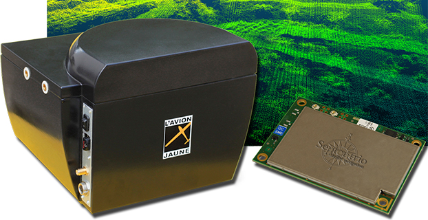
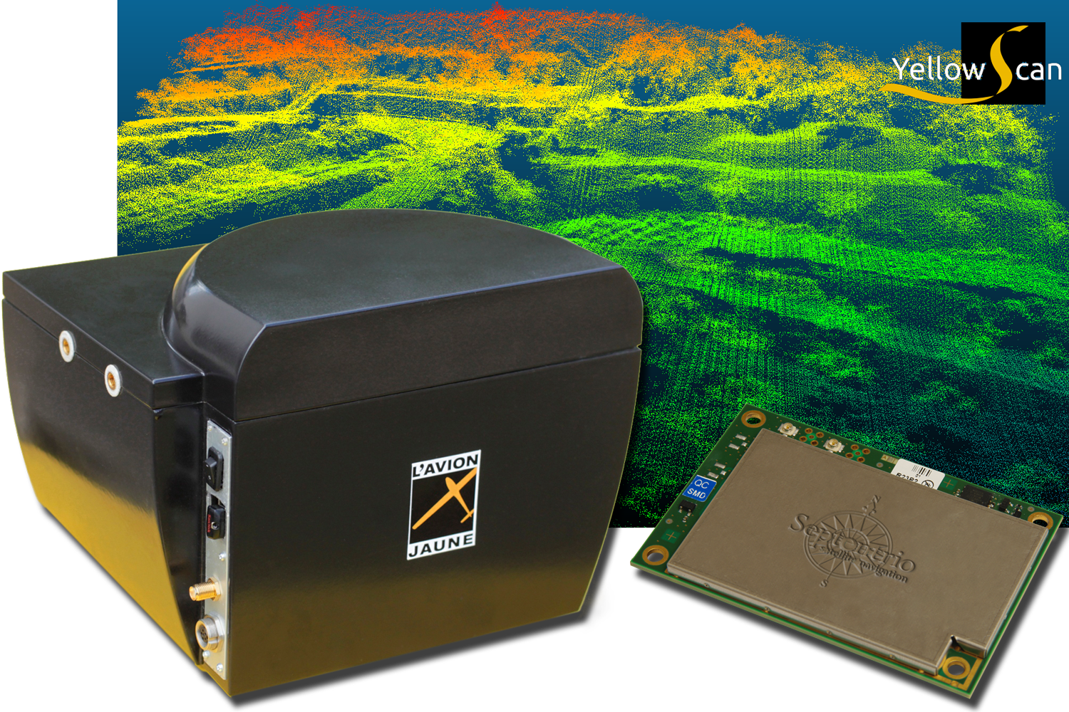
L’Avion Jaune, a service provider and airborne sensors integrator in the field of aerial surveys, has selected the Septentrio AsteRx-m to equip its YellowScan unmanned aerial system. L’Avion Jaune chose the AsteRx-m for its robustness and low-power consumption, Septentrio said.
YellowScan is the a lightweight all-in-one solution designed to deliver quality aerial surveys carried out using a LiDAR sensor aboard UAVs. The self-contained system integrates into a small package all the necessary equipment for conducting airborne surveys: a 3D laser scanner, an AHRS, a controller, an autonomous power supply module and the AsteRx-m, a high-performance precision GNSS receiver.
The AsteRx-m provides a compact and low-power solution for precise positioning in difficult environments where the tracking of both GLONASS and GPS satellites allows the receiver to improve the availability and robustness of a positioning solution. Septentrio’s newest RTK models optimally adapt to situations where GNSS signals can be distorted by reflective surfaces and feature unique countermeasures to disturbances, maintaining accurate and stable measurements wherever and whenever centimeter-level accuracy is needed, the company said.
“The easy-to-integrate AsteRx-m has proven to deliver the most reliable and stable RTK performance of all, in a compact and exceptionally low-power consumption module,” said Michel Assenbaum, CEO of L’Avion Jaune. “The AsteRx-m allows us to extend the operational range and capabilities of the YellowScan, a fully autonomous surveying solution dedicated to UAVs. We have tested the solution in various environments across the world and have never seen it falter.”
“We are delighted that L’Avion Jaune, a respected expert in designing unmanned-aerial remote sensing solutions, has validated the excellent performance of our ultra-compact GNSS receiver,” said Jan Van Hees, head of business development at Septentrio. “We are impressed to see how much interest YellowScan has drawn since its introduction and we are very proud to be contributing to the success of a best of breed solution in this highly competitive market.”
Leica Geosystems has extended its Spider product family with the new GNSS Unlimited for the Leica GR10 and GR25 GNSS receiver series, allowing receivers to be upgraded to the latest technology standards at any time. Both receivers are designed for Continuously Operating Reference Stations (CORS) infrastructure and monitoring applications, supporting GPS, GLONASS, Galileo, BeiDou and QZSS.
Also, the classic Leica GRX1200+GNSS has been enhanced to support the Chinese BeiDou navigation system.
The Leica GR10 and GR25 Unlimited are scalable reference receiver and server solutions designed for permanent and semi-permanent GNSS network installations and monitoring applications such as RTK and static networks, single base stations, field campaigns, structural monitoring, atmospheric and seismic studies and offshore positioning.
One customer, the Michigan Department of Transportation (MDOT), took advantage of the future proof concept to provide cost-efficient and reliable data products for all its CORS users. MDOT has been working with Leica Geosystems since the beginning of 2000.
“Leica Geosystems’ customer commitment and promise of future proof hardware guarantee has always ensured our investment remains current,” said Shawn Roy, statewide survey equipment development manager at MDOT. “Their promise has allowed MDOT to upgrade, modernize, and expand our network from the early GRX1200’s (GPS-only) in 2005 to the latest GRX1200+GNSS. The company’s continuous development for hardware and software on our GRX1200 family of devices has helped MDOT over the past 10 years to provide cost-efficient and reliable data products for all the users of the Michigan Spatial Reference Network and other affiliated partners, such as NGS and its data products.”
GNSS Unlimited. High-precision GNSS users are faced with an ever-changing GNSS space segment, due to its modernization. According to Leica, the GR10 and GR25 receivers provide a safe and long-term investment for CORS operators and fully support the Chinese BeiDou and Japanese QZSS systems, as well as GPS, GLONASS, and Galileo. The GNSS Unlimited series includes an upgrade to more than 500 channels that will serve the users’ needs well beyond 2020.
Both receivers allow an upgrade of all key hardware parts, such as tracking, memory, power and communications. This enables customers to always keep up with the latest technology advances at minimum cost and only when really needed. The GNSS reference receivers act just like a data center server that satisfies all needs for a reliable operation, such as backup power supplies, redundant data communications, secured access and an easy way to monitor all the servers’ activities.
GRX1200+GNSS. First introduced a decade ago, the GRX1200 series is an example of Leica’s future-proof design with a newly released option to track the signals of the Chines BeiDou navigation system. Since 2004, customers have relied on the sensor’s innovation, allowing them to maintain and increase the value of their initial investment, Leica said.
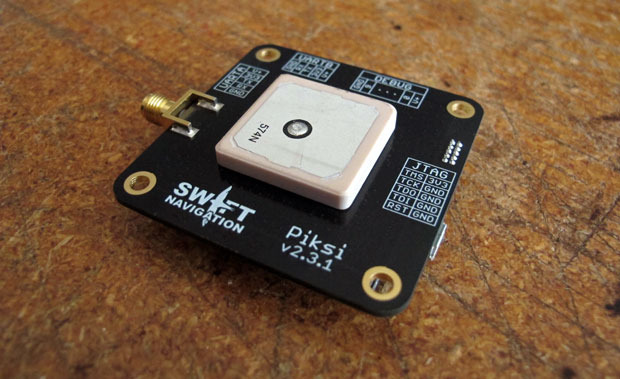
A little more than a year ago, Swift Navigation started a Kickstarter campaign for a $995 RTK GNSS receiver named Piksi. The goal was to raise $14,000 for the project. By the time the Kickstarter campaign was ended, Swift raised $166,097 from 303 backers.
I wrote an article about the Swift’s Kickstarter campaign in September 2013, a few days before the fundraising period ended. Following is a two-minute Kickstarter promotional video describing Piksi.
At the time, the $995 price for the Piksi raised a lot of eyebrows and generated conversations in the high-precision GNSS user community about inexpensive RTK technology.
This week, I took the opportunity to catch up with Swift to see how the project is going and where the company is headed.
I spoke with Tim Harris, CEO of Swift, and Fergus Noble, chief technology officer. Tim said they delivered most systems to their backers in April (2014) as well as issuing “very few” refunds, which is not unusual for Kickstarter projects. As of today, Tim said there are about 1,000 units in the field among 350+ users. He said they still consider the Piksi to be in beta testing phase and expect production units to start shipping next year.
“We are in RTK reliability mode now” — Fergus Noble
Fergus said that the hardware design is stable and hasn’t changed since they shipped Piksi last spring. He said the focus has been on refining the RTK firmware to make it robust and reliable for professional use. He admits that “covering all corners” has been a challenge and, according to Swift’s blog, “The RTK software has been a tougher nut to crack than we originally anticipated.” This is especially ambitious, since Swift said they developed the RTK firmware based on published academic technical papers, combined with their own techniques (preparing patent applications) to run on a low-power hardware platform. Basically, they started from scratch, and without any RTK veterans on their team. You gotta love their guts.
Apparently, the venture capital world liked what they saw. A few months ago, Swift, based in San Francisco, secured $2.6m in seed funding from Fall Line Capital, Felicis Ventures, Kal Vepuri, Lemnos Labs, Qualcomm Ventures and VegasTechFund. With the additional funding, Swift has increased its headcount from 4 to 9.5.
The Devil Is in the Details
Swift Navigation Lodestar. Photo: Swift Navigation
Start-ups like these are a cool story, but at some point the rubber has to hit the road. Piksi is a long way from being an RTK product that you and I use for GIS and surveying, and Tim/Fergus are humble enough to admit this. The founders see the Unmanned Aerial Systems (UAS) market as their key customer base due to Piksi’s micro-size and low cost. They say this is reflected in their current customer base, which is comprised largely of UAS users, then surveying and agriculture, with the remaining 20 percent being a variety of apps like augmented reality. I agree that UAS is the right segment for them to focus on. At this point, the limitations for general surveying and GIS use are too great:
Must use a Piksi RTK base due to the proprietary protocol. In other words, not compatible with existing RTK base stations or networks.
Baseline length (distance between the RTK base and rover) must be very short. They haven’t done much testing even with a one-mile baseline.
RTK initialization is spec’d at 15 minutes, although Fergus said it’s typically 7-10 minutes.
Since Piksi is only a single-frequency receiver (L1), it has the same limitations as other L1 RTK systems we’ve seen marketed over the past few years — short baselines and long initialization times compared to dual-frequency receivers. While these limitations are significant for surveying and GIS users, they aren’t as significant for UAS users, since UAS users require line of sight to the aircraft at all times and UAS are operated in a clear-sky environment.
Communications
If you’ve used RTK, you are aware of the importance of data communications between the base and rover. As part of its kit, Swift supplies license-free, 915MHz frequency-hopping radios to facilitate communications between the base and rover for testing. However, the founderse make it clear that they aren’t in the data radio business. They expect that most Piksi users will incorporate their own communications technology. Swift is discussing incorporating GSM (mobile phone) modem capabilities in the future.
Future
In 2015, Swift plans to roll out the Piksi in production quantities, so Fergus said their focus is on creating a robust and professional RTK system. Of course, the burning question is if/when Swift will incorporate a second GPS frequency into its receiver to take advantage of the faster RTK initialization and longer baseline distances that a dual-frequency receiver offers. Swift isn’t willing to talk about that right now. Said Tim, “We’re holding our plans close to our chest.”
The Geomatics Group, a Spectra Precision distributor and GIS software developer in Turkey, is achieving excellent success marketing the Spectra Precision MobileMapper 120 handheld GIS mapping device running Mobile GIS software developed by the Geomatics Group, according to Spectra Precision.
MobileMapper 120 uses a Windows open platform enabling it to run any Windows mobile application, including Spectra Precision applications for GIS or Survey, as well as third-party solutions that may better meet local regulations or specific customer requirements. The Geomatics Group has taken advantage of the Windows open platform to develop a specific application and integrated it with the MobileMapper 120 to provide a solution for its Turkish customers.
A Geomatics Group spokesperson says that sales of the MobileMapper 120 are particularly strong in three sectors in Turkey: mapping electrical infrastructure, orthophoto survey, and mapping public land and assets. Recently, 150 units of the MobileMapper 120 with the Geomatics Mobile GIS software were sold to the Turkey General Directorate of National Property to assist in public property management. According to the spokesperson, the sub-meter accuracy of the Spectra Precision MobileMapper 120 and the Mobile GIS software’s fast and easy menu access, hierarchical database and easily modified attribute library were important features in tests conducted by the customer. In another MobileMapper 120 sale earlier this year, 48 units were sold to the Provincial Directorates of Urban Environment for use in 48 different cities.
The spokesperson underscored the accuracy of the MobileMapper 120 that has impressed customers by reporting that one electrical grid customer who compared their ProMark 500 GNSS receiver to a MobileMapper 120, into which the Geomatics Group had installed a flying RTK option and using TUSAGA-Aktip (CORS-TR), found only a five-centimeter difference between the two receivers.
The National Geodetic Survey is seeking applicants for a geodesist (real-time kinematic network) with the Spatial Reference System Division. Applications are being accepted through December 4.
The individual selected for this position will:
Serve as subject matter expert and liaison to the Real-Time Kinematic Network (RTN) community.
Assist in defining policy and guidance related to RTN for geodetic products and services.
Serve as customer service representative responding to inquiries from various users regarding the geodetic products and services related to OPUS and RTN’s.
Perform software maintenance, development, testing, debugging, and refining NGS software to improve NGS Online Positioning User Service (OPUS) Products and Services for use in validating RTN base stations.
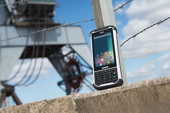
Jerker Hellström, founder and CEO of Handheld Group.
Jerker Hellström, founder and CEO of Handheld Group, has identified three key trends in mobile computing in 2015. Handheld is a maker of rugged computers for professionals.
His predictions:
1.Larger displays even for rugged mobile computers.
“Rugged laptops, tablets, PDAs and smartphones continue to be the fastest growing market mobile computer segment, and just like the screen size of smartphones for the mass market has increased, so will the displays of rugged computers. Screen size is the “$64,000 question” in the rugged computer segment — it is a major consideration for all users, but it is also linked to the application and how data and information are presented, both in terms of how it is captured and how it is communicated to the end user. I foresee a stronger demand for maximum screen real-estate in the smallest, lightest possible form factor. (One real-life example would be the recently launched Nautiz X8 by Handheld with a huge 4.7-inch display for an IP67-rated rugged device).”
2.Higher IP ratings.
“Mobile computers across all market segments are increasingly being manufactured, and marketed, as more durable, more rugged and with higher IP ratings (ingress protection against water and dust).This a function of computers, tablets and smartphones being with us all the time, everywhere. The consumers demand durable devices that can be knocked around a bit! But it has also become a marketing gimmick. Some devices are now advertized as having the previously unattainable IP68 rating. But do the customers actually understand it? It actually means nothing unless the manufacturer informs us of the submerged time and depth. I expect a continued upwards ‘IP rating creep’ but also an invigorating discussion about the definition and value of IP ratings and the tests carried out on mobile computers.”
3.Increasing interest for Android.
“Microsoft Windows Mobile or Windows Embedded has for a long time been the operative system of choice for rugged mobile devices, albeit with increasingly stronger competition from Android. 2015 will be the year when he industry truly embraces Android. The rapid growing of Android consumer phones has standardized the Android user behavior and generated a spillover effect to the industrial sector. There is an increase of industrial software being developed for Android, boosted by the first generation industrial Android devices. Also, Android can take advantage of powerful multicore CPUs in a way Windows Embedded Handheld has not been able to.“
The Nautix X8 rugged Android handheld.
Jerker Hellström is the founder and CEO of Handheld, a manufacturer of rugged mobile computers, PDAs and smartphones.Heis a pioneer and industry veteran in the mobile rugged computer industry. In both entrepreneurial and managerial positions, he has more than 25 years of experience from developing, designing, manufacturing and marketing rugged computers globally. Jerker´s educational background is in engineering and computer science.
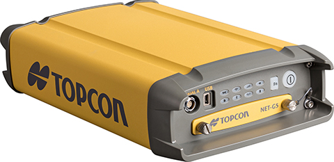
Topcon Positioning Group said that its latest GNSS reference receiver, the NET-G5, is capable of tracking a new signal from the GLONASS constellation.
The GLONASS-M 55 satellite was launched in June 2014 and is equipped with the experimental payload capable of transmitting signals in the L3 frequency band. Engineers successfully tracked the signal with the NET-G5 receiver during a series of recent tests at the Topcon Technology Center in Moscow. The use of signals in L3 band alongside L1 and L2 bands is expected to further enhance the competitiveness of the GLONASS system.
“Topcon is committed to continually investing in research and development to offer end-users and the industry the most up-to-date solutions,” said Ivan Di Federico, chief strategy officer for Topcon Positioning Systems. “Our premier engineers, scientists and designers bring world’s first products and technologies to market, and the ability of the NET-G5 to track the latest signal — a first for the industry — is an excellent example of that dedication.”
Using Vanguard and Universal Tracking technologies, the NET-G5 receiver incorporates 452-channels capable of tracking the full GNSS signal spectrum, including modernized GPS, GLONASS, Galileo, BeiDou, QZSS and SBAS signals.
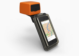
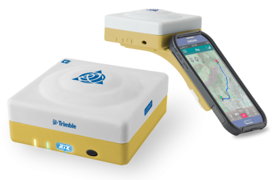
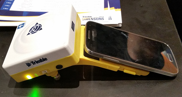
The Trimble Leap, also shown with a smartphone. Photo: Trimble
Trimble is making available the Trimble Leap, a Trimble RTX compatible GNSS Bluetooth device. When enabled with the ViewPoint RTX correction service, Leap delivers submeter accuracy directly to the Terrain Navigator Pro (TNP) Mobile app for iOS and Android devices. The TNP Mobile app allows users to collect markers, tracks and geo-stamped photos in the field, and then sync all the GNSS data into the Terrain Navigator Pro office software.
The TNP Mobile app enables users to:
Display and navigate routes created in TNP desktop.
Collect field data such as markers, tracks, photos, videos and audio clips.
Near real-time sync between phone and TNP map software via WiFi or cellular data connection.
View data on topo, aerial, and street maps downloaded to phone for offline use. Terrain Navigator Pro offers 1-meter aerial photos for the 48 contiguous United States. The seamless USGS topo graphic maps are based off 1:24K, 1:100K, 1:250K map scales. Alaska is 1:63K and 1:250K.
Access a compass and other geo-information such as lat/long, elevation, and direction on phone.
Collect data offline. The TNP mobile app uses the GPS built into the smartphones, so users can collect field data in areas without a cellular or data signal.
Trimble Leap is compact and portable, weighing 9.5 ounces. It snaps to a smartphone or tablet to use as a handheld, can be mounted on a monopole or tripod, or can be magnet mounted to a vehicle. Leap has 16 hours of battery life and uses Bluetooth communication to connect to smart devices for ease of use and flexibility. An onboard micro SD card stores the GNSS observables data for use in the field or the office.
A micro USB port can provide power to Trimble Leap for continuous fixed-mount applications, or it can be used with battery-booster products to extend field work. Trimble Leap is charged by a standard cell phone vehicle accessory charger, a USB connection to a PC, or from a USB AC adapter.
Based on Trimble RTX (Real Time eXtended) technology, ViewPoint RTX delivers better than 1 meter horizontal accuracy 95 percent of the time without the use of a traditional RTK base station or virtual reference station network. ViewPoint RTX is delivered into the TNP Mobile app via cellular data network and is available nearly anywhere in the world.
“Trimble Leap enhances the Terrain Navigator Pro solution by adding a simple way to collect submeter accurate geolocation data with standard Android or iOS devices. Adding accuracy to TNP’s robust field-to-office data collection solution provides a value-add where low-resolution collection is not sufficient. Trimble Leap with TNP Mobile is configured and operational in minutes with little training,” said Larry Fox, business area manager for Terrain Navigator Pro.
Terrain Navigator Pro integrates powerful desktop mapping software, a cloud connected mobile data collection platform (compatible with GPS-enabled iOS and Android devices) and a robust Web portal. TNP users can plan projects in the office, collect data in the field and access projects from the Web—simultaneously. Geo-referenced data such as tracks, waypoints, photographs and video can be shared, updated in near real-time and displayed on the included topographic, aerial/satellite or street base maps.
The 2014 Trimble Dimensions User Conference is being held in Las Vegas this week. Photo: Trimble
With more than 4,000 attendees, this year’s Trimble Dimensions User Conference was the largest ever and, I must say, a well-organized event chock full of technical content — enough to squelch the most intense geospatial hunger pangs you might have.
One could write a book on all the technology and market segments that Trimble is pursuing and offering solutions for. In addition to a wide range of GNSS, geospatial, construction, control, and data management systems previously offered, Trimble boasted a USB stick full of press releases with new product and service announced at Dimensions. So, the challenge is deciding what to write about without writing a little bit about everything.
After my first day at Dimensions, it became clear to me what I needed to do. Among the many product and service announcements was a new GNSS correction service named Viewpoint RTX. While I’ve tried to stay up to speed on Trimble’s various GNSS real-time correction services, this one was the straw that broke the camel’s back for me. I decided I needed to get a solid grip on the range of real-time GNSS correction services that Trimble offers because the picture was getting fuzzier, at least to me, with each new real-time correction service introduced. It used to be pretty simple to decipher; not so much any longer. So I had a conversation with Patty Boothe, general manager of Positioning Services at Trimble. Patty, a 15-year Trimble veteran, was appointed GM of the newly formed group three years ago. Here’s the low-down on the services.
Remember, Trimble acquired the land portion of OmniSTAR’s business a few years ago. For years, OmniSTAR has been one of the two dominant commercial satellite-based, real-time GNSS correction services (the other being John Deere’s Starfire service, as well as new entrant Terrastar). The OmniSTAR acquisition was Trimble’s entry into the satellite-based, real-time GNSS correction services business. Since then, Trimble has introduced the RTX (not to be confused with RTK) range of GNSS correction services. You might say that OmniSTAR and RTX are competitive services within Trimble. They are, to a certain extent, and I’ll attempt to clarify that below.
Following is a list of Trimble’s real-time GNSS correction services, starting with the OmniSTAR services:
OmniSTAR VBS: Satellite-based, real-time submeter service. The VBS service has been made obsolete largely by free public satellite-based augmentation systems (SBAS) such as WAAS/EGNOS/MSAS/GAGAN/SDCM. It is still used in geographic regions where free public SBAS don’t exist, primarily South America, Central and Southern Africa, and Australia. GPS-only service. Requires single-frequency receiver (L1).
OmniSTAR XP: Satellite-based, real-time 15-cm service based on Jet Propulsion Lab (JPL) technology and delivered to users on the ground via OmniSTAR’s geosynchronous satellite network. GPS-only service. Requires dual frequency (L1 and L2).
OmniSTAR HP: Satellite-based, real-time 10-cm service based on OmniSTAR’s reference station network and delivered to users on the ground via OmniSTAR’s geosynchronous satellite network. GPS-only service. Requires dual frequency (L1 and L2).
OmniSTAR G2: Satellite-based, real-time 10-cm service based on Jet Propulsion Lab (JPL) technology and delivered to users on the ground via OmniSTAR’s geosynchronous satellite network. GPS+GLONASS service. Requires dual frequency, dual constellation (L1 and L2).
To use OmniSTAR services, one must have an OmniSTAR-enabled GNSS receiver. There are a several receiver manufacturers that support OmniSTAR GNSS correction services, such as NovAtel and Hemisphere GNSS, in addition to Trimble.
After, or at nearly the same time, Trimble acquired OmniSTAR, the company launched its RTX GNSS correction service. RTX’s infrastructure consists of ~110 GNSS reference stations around the world working to create high-precision corrections on a near global scale. The first significant differentiator is that Trimble RTX services are only offered on Trimble GNSS receivers, so you’ve got to be “all in” with Trimble to utilize RTX.
Viewpoint RTX: Internet-based (notice I didn’t write satellite-based), real-time submeter service. This is a new service introduced this week at Dimensions for the new Leap GNSS receiver and the Geo7 GNSS handheld. GPS+GLONASS service. Requires single-frequency receiver (L1).
The above are the three RTX services. There are some options for the above, but let’s talk about satellite-based GNSS correction services for a minute.
The advantage of satellite correction services is that, because GNSS corrections are delivered via satellite, your receiver doesn’t need to be connected to the Internet or have any other sort of terrestrial radio communications to receive data from the GNSS reference station(s). Because delivery is by satellite, you could be in the middle of a desert with no mobile phone coverage within 100 km, and you could still use OmniSTAR or RTX services. The only requirement is that your receiver needs to have direct, continuous line-of-sight to the OmniSTAR/RTX geosynchronous satellite (both services use the same geosynchronous satellites to broadcast the corrections).
The primary disadvantage of OmniStar and RTX services is the “convergence” time required to achieve the stated accuracy service levels. With the exception of OmniSTAR VBS (sub-meter), Viewpoint RTX (sub-meter) and Rangepoint RTX (50-cm) services, the OmniSTAR and RTX centimeter and decimeter services require tens of minutes of initialization time to converge to the stated accuracy. For example, if you want to use the 4-cm Centerpoint RTX service, you may have wait up to 30 minutes for it to converge to 4-cm accuracy.
Now, there are a couple of ways to reduce the convergence time:
Start on a known point. For example, if you’re using Centerpoint RTX on a tractor for planting and you shut down for the evening, you can start it up the next morning (assuming you didn’t move the tractor), and it will converge nearly immediately.
Trimble offers a fast convergence option ($) in some geographic areas where it augments RTX with local RTK reference stations. Currently, Trimble offers this service in five U.S. “corn belt” states.
For OmniStar XP, HP and G2 services, the only way to reduce convergence time is number one above, start on a known point.
It’s important to note that all of the centimeter and decimenter satellite-based services described above are based on real-time Precise Point Positioning (PPP) technology, which is different than RTK technology. The fundamental difference is that real-time PPP technology relies on a global, distributed network of reference stations. For example, Trimble has ~110 reference stations to cover the globe (mostly) with its RTX service. On the other hand, RTK requires a much more dense network of GNSS reference stations. For example, in Washington State there are ~100 GNSS reference stations that comprise the state-wide RTK network.
Lastly, Trimble offers a hybird RTK/RTX service called XFill. The idea is that for RTK users who lose communications to their RTK base or RTK network can use the Centerpoint RTX as a “seamless” back-up, maintaining RTK-level accuracy (1-2cm) for the first five minutes of RTX service, and then degrading to Centerpoint RTX accuracy after 20 minutes. Trimble reports there is no convergence time when transitioning from RTK to RTX, like you would if you were starting RTX right away. Standard XFill is included with certain Trimble RTK receivers and allows up to five minutes of RTX satellite time. Last month at the INTERGEO conference, Trimble introduced Expanded XFill which is a subscription service for those users who want more than five minutes of RTX time. For those users, Patty said that users can buy blocks of RTX time starting at 10 hours.
So, you might ask how Trimble handles the horizontal datum differences between RTK and RTX since they are likely not referenced to the same horizontal datum. For example, in the US, Trimble VRS RTK infrastructure is typically referenced to NAD83/2011 while Trimble RTX is referenced to ITRF08. There’s about 1 meter difference between the two. After finding the correct Trimble person, he said that Trimble does a 3-parameter local shift (dX, dY, dZ) on the fly when in RTK mode so that when there’s a transition from RTK to RTX, the horizontal datum difference is already resolved.
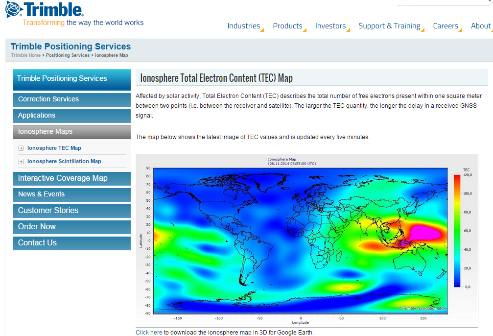
A by-product of Trimble’s ~110 global GNSS reference station network is a real-time, world-wide TEC (Total Electron Content) map. Since real-time PPP GNSS correction services (and public SBAS like WAAS/EGNOS/MSAS/GAGAN) rely on accurate models of the TEC in the ionosphere to account for the GNSS measurement delay, real-time TEC maps give users an indication of how the ionosphere’s TEC is behaving. This sort of map is particularly useful in attempting to predict the understand single frequency receivers using services such as public SBAS, OmniStar VBS, and Viewpoint RTX. The next time you here about an impending solar storm, take a look a the map using this link and see the TEC hotspots around the globe. Notice the more intense activity near the geomagnetic equator.
TEC map from Trimble’s ~110 global GNSS receivers. Photo: Trimble
Shifting gears slightly, at the conference, Trimble also introduced a new mobile phone GNSS add-in product called Leap, which uses the Viewpoint RTX service.
Trimble Leap GNSS Receiver with a Samsung Galaxy Phone. Photo: Trimble
Trimble has introduced the latest version of its smart water infrastructure mapping and work management cloud software — Trimble Connect for Water version 1.9.
The latest release of the geographic information system (GIS) centric software-as-a-service (SaaS) adds real-time, high-accuracy centimeter-level horizontal and vertical GNSS accuracy for capturing 3D asset positions. The new release includes a suite of applications that allow water, wastewater and stormwater utilities to accurately locate, inventory and visualize their infrastructure assets and increase operations and maintenance efficiency.
Trimble Connect for Water cloud software leverages Trimble’s GNSS rugged mobile devices and Esri’s GIS technologies to accurately map, locate and assess the condition of critical infrastructure assets, allowing utilities to keep their field infrastructure data up-to-date and accurate.
The new release now supports Trimble’s Geo 7 Centimeter Edition rugged handheld, integrating 3D mapping into utility field workflows and enabling mobile workers to precisely locate and map the horizontal position and elevation of buried infrastructure.
Trimble Connect for Water version 1.9 can be configured and deployed quickly on a variety of Trimble and non-Trimble mobile devices, laptops, tablets and smartphones, including Apple iPads, iPhones, Android, Windows and Windows Mobile devices to automate fieldwork and eliminate paper-based maps.
Trimble Connect uses the latest Esri ArcGIS for Server, Mobile and ArcGIS Online basemap services. The software is designed to automate a variety of specific water, wastewater and stormwater industry workflows through individual pre-configured “apps” offered within the product and as part of a subscription.
The new version provides standard core apps including Map Book, Manhole Inspector, Leak Repair, Hydrant Inspector, Valve Inspector, Meter Changeout, Incident Repair, Water Mapper, Wastewater Mapper and Stormwater Mapper. In addition, an optional partner app developed for American Flow Control (AFC) hydrant and valve data collection, “AFC Mapper,” can be purchased from AFC and their distributors for use with Trimble rugged handhelds.
Trimble Connect for Water version 1.9:
Offers centimeter-level real-time GNSS accuracy to improve the quality and accuracy of the utility’s GIS data to precisely locate hard to find assets.
Allows capturing accurate vertical elevations in real-time. Combined with horizontal precision, the solution provides high-accuracy GIS data that can be used to measure pipeline slopes, perform flow analysis and generate 3D and hydraulic models.
Supports the Trimble Geo 7 Centimeter edition with an integrated laser rangefinder.
Offers pre-configured Water, Wastewater and Stormwater mapping apps, allowing utilities to quickly start mapping network infrastructure and updating their asset data.
Provides the capability to export data in a variety of formats including Esri File Geodatabase, Shapefiles and MS Excel, which allows users to update the utility’s enterprise GIS or visualize and analyze the collected data using third-party systems.
Trimble Connect for Water version 1.9 is expected to be available in December 2014 from Trimble’s Water Division and its authorized distribution partners.