On Nov. 18, the European Space Agency (ESA) announced a Navigation Innovation and Support Programme (NAVISP) partnership with Italy’s Grimaldi Group, as the need for accurate maritime navigation increases. With the Grimaldi Group, NAVISP has taken on the Grimaldi Satellite-Assisted Berthing (GSAB) project, which aims to develop a satellite-based guidance system for docking maneuvers of large vessels.
NAVISP’s GSAB project will use satellite-based multi-sensor technology to improve the efficiency of maneuvers in ports to increase safety while also reducing CO2 emissions. Maritime navigation is too complex for GPS and Galileo alone, so, by fusing those two systems with PNT sensors, the project can achieve its intended outcome.
The project is divided into two phases. In the first phase, NAVISP is working on design, development activities, installation of the sensors in a roll-on, roll-off vessel, and running a test readiness campaign. The second phase includes field tests with the equipped ship in the Grimaldi facilities in the Port of Antwerp-Bruges, Europe’s second largest seaport.
Shipping transport is responsible for more than 80% of goods traded globally, and the Grimaldi Group is one of the largest shipping companies globally with more than 130 ships. As the need for efficient and safe ship transport in and out of ports grows, NAVISP continues to support innovation to improve satellite navigation and positioning systems in the maritime sector, according to ESA.
One of several derivative branches from unmanned air vehicles and their technologies is electric aircraft and air taxis. Referred to as eVTOL (electric Vertical Take-Off and Landing), a class of manned and unmanned aircraft is being developed and certified for short-hop passenger transit from down-town ‘Verti-Ports’ to classic airports, aimed at improving the economics and reducing the noise footprint of current helicopter services. Urban air transport is undergoing significant change as organizations such as United Airlines, Delta, American Airlines and others plow money into electric aircraft and the development of manned and unmanned air axis.
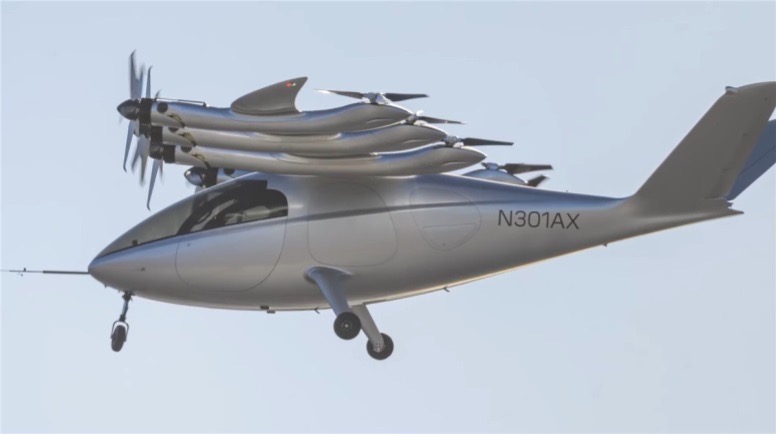
Archer Aviation is developing two such aircraft, with ‘Maker’ being the first cut flying test-bed, and ‘Midnight’ its so called ‘first production version.’ The vehicle design is similar in that they both have wings and are powered by six lift propellers and six tilting props that rotate vertically to lift for take-off and landing, then transition to horizontal for forward flight.
Image: Maker in forward flight/ArcherImage: Midnight/Archer
In the past, Archer has been somewhat secretive about its air-taxi program, but with the introduction of Midnight on Nov. 17, and with Maker achieving transition from hover to forward flight on Nov. 20, they released some useful information. Lift to forward transition is a big step for eVTOL, with the potential for a major set-back, almost like an irrecoverable stall for a fixed wing aircraft.
There are six battery ‘packs’ mounted in the wing near the engines – batteries, engines and FAA certification are key focal areas in their program, with fault tolerance and endurance being key considerations. An existing lithium battery has been selected following extensive testing, with a design objective of 10,000 average 20 mile trips, each trip with a 10 minute recharge cycle. Two similar electric motor types are used, with 95% commonality, and flight can allegedly be maintained through one complete engine or propeller failure. Each engine has redundant elements allowing one side to fail while still maintaining full operation. All these redundancies support the Archer plan for FAA certification which has now progressed through ‘Certification Basis’ and ‘Conceptual Design’ to ‘Preliminary Design’. There are many steps still to complete, with certification not anticipated until at least the second half of 2024.
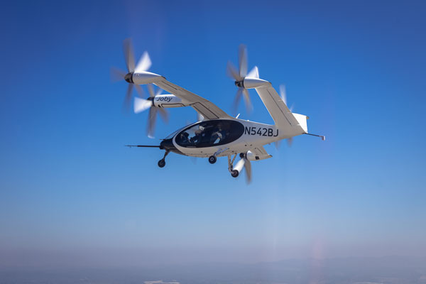
Meanwhile, Joby Aviation has been making significant progress with its flying prototype and pre-production aircraft, with the objective of developing a flying rideshare platform. With space for four passengers and a pilot, the Joby aircraft is smaller than the Archer vehicle, however smaller size means less weight and complexity and requires fewer lift props. The Joby vehicle has six large props that all transition from vertical for take-off and landing to horizontal for full forward flight.
Image: Courtesy of Joby Aviation. (c) Joby Aero, Inc.
Joby developed its own lithium-iron batteries and dual redundant electric motors and while developing flying prototype and pre-production aircraft, has also focused on teaming with key industrial partners who are assisted in key areas:
NASA has undertaken a study with Joby on 5 potential route configurations at Dallas/Fort-Worth airport for eVTOL traffic.
The US Department of Defence has provided flight range and facilities to enable airborne testing of the Joby prototypes. This contract has just been modified so that US Marine Corps personnel may flight test Joby’s eVTOL to evaluate DoD use-cases for the aircraft.
The company ‘Uber Elevate’ was purchased by Joby and is now integrated as the future provider of trip access for customers.
Toyota has not only invested in Joby, but is providing essential production facility knowledge and guidance as Joby begins its initial build out of volume manufacturing.
Delta has invested an initial $60 million, which could increase to $200 million provided progress towards certification and service entry meets certain milestones
Other eVTOL notable companies entering this market include Jaunt Air Mobility in Dallas, Texas; Velocopter in Bruschal, Germany; Lilium in Munich, Germany; Kittyhawk in California; Wisk in California and New Zealand; Airbus in Toulouse, France; Ehang in Guangzhow, China; Vertical Aerospace in Bristol, England; Urban Aeronautics in Tel Aviv, Israel; and Eve Mobility in Melbourne Florida.
So, just a small taste of two of many eVTOL hopefuls – but two with the backing of mainline commercial airlines – who knows who will actually make it through the arduous and expensive aviation certification process before the cash runs out? However, there are many significant investors who are currently standing by their selected hopefuls and others continue to jump in – let’s hope that by 2025 we’ll begin to see home-airport air-taxi services underway.
Bikes have been used for centuries for transportation, exercise, and recreation. Now, thanks to developments in battery technology and growing environmental concerns, sales of e-bikes are exploding.
The Roundup has estimated that 300 million e-bikes will be used around the globe by next year, with annual sales reaching 10 million by 2024 and 17 million by 2030.
Mapbox, a platform that provides maps and location data for developers and works with such notable companies as Strava, General Motors, and Instacart, offers micro mobility solutions to help e-bike companies develop advanced navigation systems. E-bike maker Cowboy, and shared micro-mobility operator TIER Mobility, use Mapbox for their customizable navigation technology that provides turn-by-turn navigation with voice guidance, route optimization, traffic history and more.
Mapbox co-founder and principal evangelist Will White understands the capabilities and limitations of e-bikes that need to be considered when designing navigation technology for them. He pointed to two main obstacles to the adoption of e-bikes: rider safety and security from theft.
With these obstacles in mind, Mapbox is developing improvements in the ability to track the precise location of e-bikes by using their navigation platform. Additionally, White predicts that most e-bike companies will start to include radar devices to detect obstacles ahead and vehicles approaching from behind, as well as cameras, artificial intelligence and more to improve rider safety.
White is optimistic that e-bikes will be adopted as a mainstream form of transportation and is excited for Mapbox to be on the forefront of that innovative navigation technology.
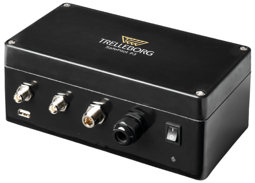
On Dec. 15, Trelleborg Marine and Infrastructure released SafePilot P3, a navigation system that meets Panama Canal Advisory (ACP) standards, which go into effect late next year for Neopanamax vessels. The navigation system provides real-time data on vessel positioning and movement in tight waterways.
SafePilot P3 operates on motion sensors and two GNSS antennas to measure the position and heading of vessels in three dimensions, minimizing time and difficulty associated with piloting procedures. SafePilot P3 has a backup battery to maintain functionality in the event of a power outage.
Image: Trelleborg SafePilot P3
This navigation system improves situational awareness while navigating waterways and ports globally, as it integrates with the ACP-approved Trelleborg SafeCaptain App. It also enhances communication between the captain, pilot, tug operators and canal personnel while vessels are transiting the canal and approaching the port.
SafePilot P3 is an addition to Trelleborg’s SafePilot portable navigation systems, which provide ports with real-time navigation information while giving pilots greater control and accuracy when approaching ports and performing intricate maneuvers.
San Francisco local officials are questioning the safety of autonomous vehicles (AV), also known as self-driving cars, due to frequent reports of traffic violations, delaying public transportation and emergency vehicles, causing traffic congestion as well as driving onto public sidewalks.
California officials granted the first AV deployment permits this year, allowing companies to release self-driving cars onto city streets and to provide passenger service as robotaxis. Since granting permits to AV companies such as Waymo and Cruise, self-driving vehicles have been creating a multitude of issues with public safety, including a recent incident of a Cruise AV stopping a bus on its route for over seven minutes.
As state governments have the legal power to grant permits to AV companies to conduct testing and ride hail services, city officials are left powerless to control self-driving car incidents that affect residents and public safety. City officials also struggle to obtain information regarding AV-induced road blockages and even a comprehensive list of all companies have deployed self-driving vehicles onto their roads.
Europe’s regional satellite-based augmentation system (SBAS), EGNOS, has received upgrades to advance the reliability of GNSS positioning information, according to EUSPA.
Historically, EGNOS has provided safe, uninterrupted satellite navigation services to aviators, and some maritime, railroad, and land-based users in Europe. This system upgrade includes extending its service area, adding advanced functionalities, and reinforcing dual-frequency and multi-constellation services.
The EGNOS V242B system upgrade will expand services outside of its service area and enhance availability to users. Additionally, the upgrade ensures aviator access to lifesaving services such as Localizer Performance with Vertical Guidance (LPV)-200. The upgrade also includes more advanced data processing functions to cater to increased issues with peak solar activity and ionospheric phenomena that interfere with EGNOS signals and services.
Dual-frequency and multi-constellation services were also improved in the EGNOS upgrade. The improvements revamped EGNOS Version 2, and reinforced EGNOS services before launching EGNOS Version 3 (V3).
EGNOS delivers two frequencies and has amplified Galileo signals, hence creating a multi-constellation capability. When EGNOS V3 is launched, it will offer additional services and enhance protection against cyberattacks, further advancing EGNOS’ safety-critical applications across Europe.
Mapbox, a maps and location platform, has created new productsand platform updates to aid developers in making more accurate, data-driven decisions and improving overall user experience with advancement in location technology.
Navigation SDK v2.9 was introduced to provide pre-built navigation applications, compatible with Android and IOS, which will provide all the primary navigation components across a workflow using lines of code instead of starting from square one. The Drop-in UI is customizable to create applications that reflect a developer’s brand, rather than needing to manually develop a full end-to-end application.
Image: Mapbox
Navigation SDK Copilot, a backend analytics tool for CX on navigation applications, was launched and designed by Mapbox to collect trace files of navigation sessions and search analytics data from users. Developers can use this data to gather feedback and collective user data to create touch points with users and improve application experience based on their data-drawn conclusions.
Mapbox’s platform updates and product innovation also include improvements to its Matrix API, which can now support scheduled departure times and provide optimal driving routes creating a more accurate ETA. This innovative location technology is also designed to enhance fuel efficiency and decrease emissions.
Image: Mapbox
As map boundaries are constantly changing, Mapbox has expanded its visualization of map lines to update as frequently as the lines change. The expanded visualization makes updates quicker and improves the ability of Mapbox’s platform to give users the most up-to-date information.
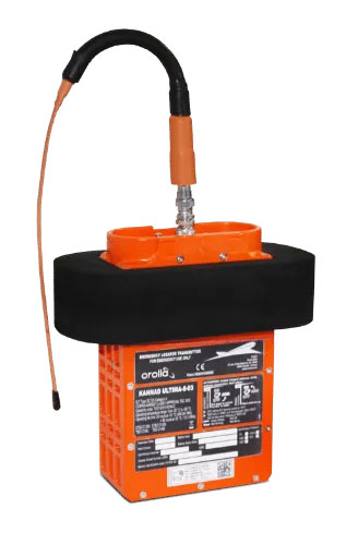
New-generation aircraft ELT meets new European Union Aviation Safety Agency (EASA) and U.S. Federal Aviation Administration (FAA) requirements
Photo: Orolia
Orolia has received certifications for yet another survival emergency locator transmitter (ELT), the Ultima-S.
The news follows Orolia’s announcement that it had received certification for the Ultima-DT model, as well as a personal locator now shipping to the U.S. Army.
The Ultima-S is a new generation ELT installed in either the cabins or liferafts of aircraft. It relays accurate aircraft location information to search-and-rescue teams.
Once activated, a 406-MHz distress signal is transmitted and includes the ELT’s location thanks to the Ultima-S internal GNSS receiver. This built-in GNSS capability increases both probability and speed of detection of the distress signal.
“With these key certifications for the Ultima-S, Orolia brings a long-awaited solution to the industry,” said Jérôme Ramé, Orolia’s Aviation & Military Product Line Director. “We have developed strong partnerships with several of the leading aircraft manufacturers that will enable operators worldwide to benefit from the Ultima-S for both their linefit and retrofit needs, allowing fleet standardization.”
The Ultima-S provides free, global coverage service through the dedicated Cospas-Sarsat infrastructure while meeting the highest aviation safety standards. Orolia offers non-rechargeable lithium batteries compliant with the latest FAA and EASA special conditions standards, also known under TSO-C142b/DO227A. The Ultima-S also meets the most recent ELT performance and environmental standards through TSO-C126c.
“What makes the Ultima-S unique is a new feature called the Return Link Service (RLS),” said Ramé. “Through this capability, the user is automatically notified when the distress signal is detected and located by the Cospas-Sarsat ground infrastructure. The Ultima-S links directly to the European Galileo GNSS satellite constellation, providing the most reliable and timely information for reaching aircraft crew members in distress.”
In addition to being available on a linefit basis on major aircraft programs, Orolia has launched an exchange program to make retrofit activities easier for airlines, especially those upgrading to safer battery technology.
GNSS receivers are now routinely integrated into every kind of vehicle, vessel and aircraft, often in conjunction with other technologies that can be used for positioning and navigation, such as inertial navigation, radar, lidar, sonar and computer vision. This month’s cover story highlights case studies from Hexagon, Orolia, Trimble, CHC Navigation and XenomatiX that increase safety, improve service, lower costs and reduce emissions.
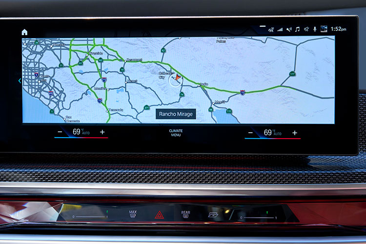
The BMW 7 Series rolls out SAE Level 2+ at a speed of 130 km/h in the United States and Canada. HERE also provides the BMW 7 Series with Predictive Routing and Real-Time Traffic information.
BMW Group is using the HERE Technologies HD Live Map to enable hands-free driving in the United States and Canada, starting with its 7 Series.
Following a long-standing collaboration between BMW and HERE on next-generation mapping capabilities, HERE now provides high-definition maps for Level 2+ automated driving capabilities in series production vehicles.
The BMW 7 Series is the automaker’s first production vehicle to launch with SAE Level 2+ automated functionalities at a maximum speed of 80 mph (130 km/h). The function enables hands-free driving on interstates and highways, provided drivers remain focused and ready to take control.
Photo: HERE Technologies
The HERE HD Live Map will be integrated into additional BMW models as automated driving capabilities increase across vehicles, roadways and regions.
The HERE HD Live Map consists of rich, highly accurate and fresh layers of data to support the vehicle in knowing exactly where it is on the road, and what road features lie ahead.
HERE HD Live Map helps a vehicle to proactively adjust its behavior to upcoming road characteristics.The lane-level data serves as a redundant source of information to the onboard sensors, providing additional safety assurances for the system.
Photo: BMW
The BMW 7 Series is also the first vehicle to deploy HERE Predictive Routing, a cloud-based routing functionality that learns individual driving patterns to propose more personalized journeys.
In addition, the BMW 7 Series uses HERE Real-Time Traffic across 70 countries. The service delivers drivers detailed information on traffic congestion with lane-level precision and potential road hazards ahead, with auto re-routing capabilities, helping drivers stay safe and save time.
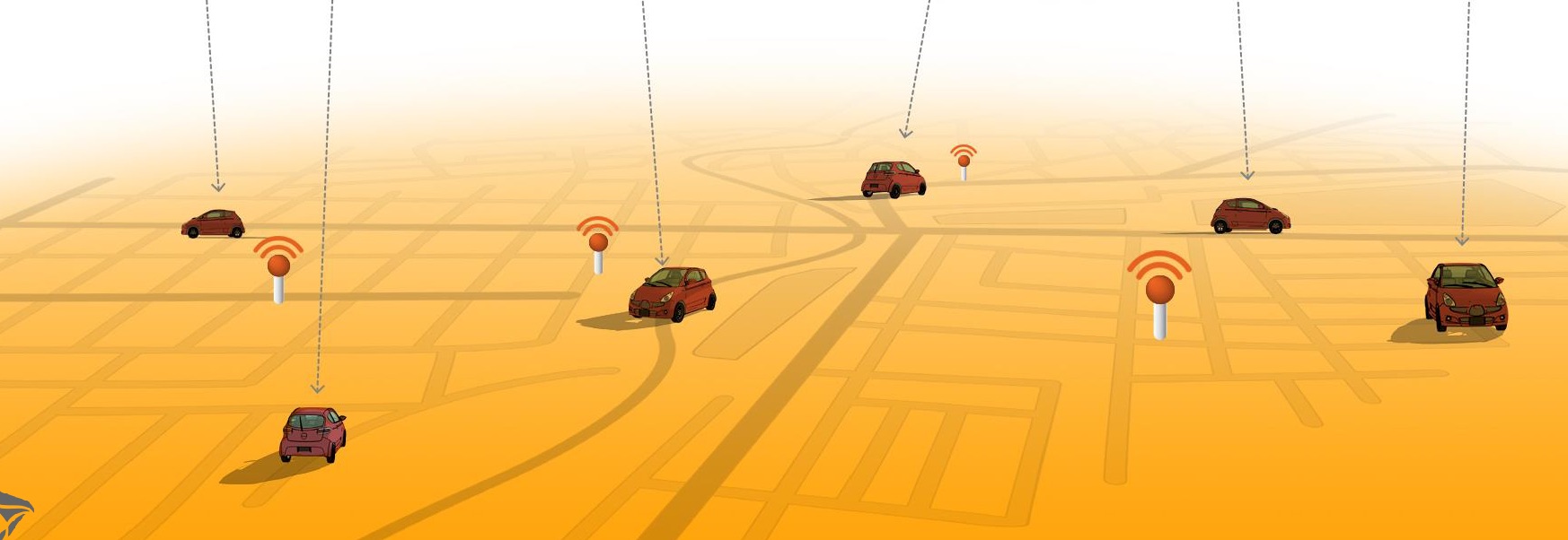
Swift Navigation has expanded the capabilities of its Skylark precise positioning service to several product tiers. With new services providing real-time kinematic (RTK) and differential GNSS (DGNSS) options, Swift meets the broadening needs of its growing customer base.
In addition, new BeiDou signal support and regional coverage has been added.
Skylark is Swift’s cloud-based GNSS corrections service designed to deliver affordability, high accuracy and fast convergence, eliminating the complexity of deploying and maintaining GNSS networks. The expansion of Skylark’s capabilities makes it possible for customers across industries to benefit from seamless corrections to applications across the globe, the company said.
Skylark RTK delivers Swift’s highest tier of performance to third-party GNSS receivers. Compatible with leading RTK receivers on the market, Skylark RTK delivers corrections for applications that require sub-2 cm accuracy, including agriculture, machine control, drones and robotics in the United States, Europe and select Asian countries.
Skylark DGNSS is suitable for mobile applications, delivering real-time, high-reliability differential GNSS corrections to mobile handsets, positioning engine modules and mass-market applications. Skylark DGNSS enables lane-level location accuracy, in turn enabling new consumer location experiences and improving location-based services to increase efficiency on a global basis.
With BeiDou coverage already available across the United States, Japan and Korea, Swift has now added BeiDou signal support for the European Union, supplementing existing support for Galileo and GPS by providing corrections for GPS L1/L2/L5, Galileo E1/E5b/E5a and BeiDou B1/B2a. In addition, support for BeiDou B1C has been added to all regions.
These additions help support newer mass-market RTK-enabled receivers to achieve high-accuracy performance in difficult GNSS environments and continue to push the envelope for positioning accuracy.
“Swift was founded on the notion of improving GNSS positioning performance for mass-market applications,” said Holger Ippach, executive vice president of product, Swift Navigation . “We are pleased to expand the functionality of Skylark to improve the positioning functionality for many more customers across the globe.”
The suite of Skylark products was built from the ground up for scale, resilience and ease of integration. Skylark delivers seamless corrections to continents and countries across the globe including the United States, Europe, South Korea, Japan, Taiwan and Australia.
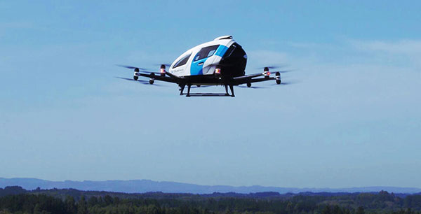
EHang deployed its EH216 eVTOL for flight trials in Europe including the recent Air Mobility Urban-Large Experimental Demonstration. (Photo: EHang)
EHang will deploy its EH216 autonomous aerial vehicle in a European Union-funded project that is assessing how the European Geostationary Navigation Overlay Service (EGNOS) could be used for electric vertical-takeoff-and-landing (eVTOL) aircraft operations.
The fully autonomous, all-electric vehicle will be used for flight trials at Lleida-Alguaire Airport in Spain as part of the Satellite Based Augmentation System Adoption in Multicopter VTOL Aircraft (SAMVA) program.
As part of an initiative of the European Union Agency for the Space Programme (EUSPA), the SAMVA project is tasked with establishing how EGNOS could support planned air mobility services, including eVTOL air taxi flights. It is also intended to prepare for uncrewed vehicles to use the new U-Space concept for managing autonomous or remotely piloted aircraft.
Aeroports de Catalunya will help China-based EHang to establish an operational center at its Lleida-Alguaire facility in the Catalonian region of northeast Spain. The EH216 will use the EGNOS technology to conduct unmanned traffic management (UTM) tasks and to demonstrate how eVTOL aircraft could operate in urban environments, including to and from airports.
EHang is working to achieve Chinese certification for the two-seat EH216, which it intends to deploy with partners and customers for services such as air taxi and sightseeing flights. It also aims to get approval for its aircraft to operate in Europe and has been active in other air mobility partnerships in Europe, where it has provisional customers in places like Norway.
In October, EHang completed its participation in the European Union’s Air Mobility Urban-Large Experimental Demonstration (AMU-LED) with a series of flight tests in Spain. The company — one of 16 consortium members in the AMU-LED program — demonstrated the EH216 at the Rozas Airborne Research Center, which is part of Spain’s National Institute of Aerospace Technology.
“The SAMVA project will unleash EGNOS capabilities aboard EHang’s EH216 AAV to provide precise and integral navigation guidance and support U-Space airspace integration,” said Victoria Jing Xiang, the company’s chief operating officer for Europe and Latin America. “Our participation in this project reflects the meaningful progress we’ve made overseas with our strong technologies as our global footprint expands.”