Category: Transportation

  • Siemens integrates u-blox module into V2X test fleet

    The ZED-F9K turnkey solution minimizes the effort required to achieve decimeter-level positioning accuracy in automotive applications.

    Siemens has integrated the u-blox ZED-F9K high-precision dead-reckoning module into its Toyota Prius V2X (vehicle-to-everything) test fleet. Siemens carried out live demonstrations of the technology at ITS European Congress 2019 in Eindhoven, the Netherlands.

    As the only available source of absolute position, GNSS-based positioning plays a crucial role in advanced driver automation systems and driverless vehicles. The same is true in V2X communication, in which vehicles continuously share their location and other information with other traffic participants — cars and pedestrians — as well as surrounding infrastructure, improving road safety and reducing traffic congestion.

    V2X test vehicles typically determine their position using high-end GNSS  receivers. By opting to use the ZED-F9K, Siemens was able to align the performance of their test fleet with real-world conditions while also reducing the cost and the engineering effort required to develop their vehicles.

    Siemens conducted V2X tests using the u-blox ZED-F9K during ITS European Congress 2019. (Photo: u-blox)
    Siemens conducted V2X tests using the u-blox ZED-F9K during ITS European Congress 2019. (Photo: u-blox)

    “We’ve had a very positive experience with u-blox’s ZED-F9K high precision dead reckoning solution. The product delivered strongly from the initial design-in to the data and performance in our first tests,” said Igor Passchier, engineering fellow, Connected and Automated Driving at Siemens PLM Software.

    “Our collaboration with Siemens shows the extent to which the ZED-F9K turnkey solution saves OEMs time, cost, and engineering effort while providing decimeter-level positioning performance,” said Alex Ngi, Product Strategy for Dead Reckoning, Product Center Positioning, u-blox. “For us, it has also been a welcome opportunity to contribute to solving the challenges in the autonomous driving ecosystem.”

  • SoftBank goes hard on autonomous positioning in Japan

    SoftBank plans to introduce a centimeter-accurate, real-time satnav-based positioning service, specifically using Japan’s Quasi-Zenith Satellite System (QZSS), to guide autonomous vehicles across a range of industries in Japan. The company said it will install more than 3,300 control points at base stations across Japan to deliver centimeter-level accuracy over its mobile network coverage area to provide real-time kinematic (RTK) positioning.

    Testing begins in July with a scheduled launch of commercial service by the end of November. Test partners include Yanmar Agribusiness Co., Ltd., a provider of autonomous assisted driving for agricultural machinery, Kajima Corporation, which performs construction site management with automatically controlled drones for aerial photography and monitoring, and SB Drive Corp., a provider of autonomous and assisted driving technology for buses.

    SoftBank is developing proprietary low-cost GNSS receivers so that “new services and market expansion can be realized.” A Positioning Core System provided by ALES Corp. will generate correctional data based on signals received and transmitted by SoftBank’s own control points over SoftBank’s mobile communications network to agricultural and construction machinery, self-driving cars, drones and other equipment carrying GNSS receivers. The company expects that centimeter-level positioning can thus be done in real time.

    In addition to control points at its own base stations, SoftBank will use the Geospatial Information Authority of Japan’s approximately 1,300 GPS-based control stations.

    SoftBank is also developing services to enablec loud-based RTK positioning for devices without GNSS receivers. Cloud-based RTK will provide centimeter-level, location-based services for equipment that needs to be miniature and energy-efficient, such as infrastructure surveillance sensors and wearable devices.

    SoftBank Group Corp. is a Japanese multinational conglomerate holding company headquartered in Tokyo. It owns operations in broadband, fixed-line telecommunications, e-commerce, internet, technology services, finance, semiconductor design and more. It is the 36th largest public company in the world, and the 2nd largest in Japan.

    ALES is a joint venture established by SoftBank and Enabler in July 2018. Enabler employs GNSS and related technologies to produce such products/services as a synchronization solution for mobile base stations for subway stations and a patented indoor positioning/time synchronization infrastructure platform in Japan.


    Featured image: Softbank

  • Autotalks and Marben join on live V2X demo

    Graphic: Autotalks
    Graphic: Autotalks

    Autotalks, a vehicle-to-everything (V2X) communications company, has teamed up with Marben for a live V2X demo based on Marben V2X software running on Autotalks’ chipset.

    The first live end-to-end global V2X demo will take place at the Autotalks booth (C198) at TU-Automotive Detroit, being held June 5-6 in Novi, Michigan.

    The joint demonstration will show V2V applications running using both DSRC and C-V2X standards and leverages the ability of the Autotalks’ chipset to support both.

    Autotalks has been cooperating for several years with Marben, a global leader in embedded software solutions for the telecommunication and automotive industries. The joint effort led to the successful integration of Marben’s stack and software application on Autotalks chipset using the C-V2X standard.

    The Autotalks solution minimizes development, testing and certification efforts for a V2X system to be deployed anywhere, using a software toggle between V2X technologies. This translates into a huge advantage for OEMs and Tier 1 automakers who benefit from the shortest time to market for a global V2X platform.

    The chipset isolates V2X from the non-safety domains, thus providing domain separation and security, scalability and ability to optimize the cost structure of telematic control units (TCUs). The isolation of V2X combined with Autotalks’ recognized cyber security technology enables a secure platform.

    “Our agility in maturing the C-V2X solution simultaneously with leveraging our V2X ecosystem partners for this purpose has yielded fast results and offers a clear deployment path for OEMs and Tier 1s alike. We appreciate Marben’s long-standing cooperation and are pleased to demonstrate the first end-to-end dual-mode V2X demo with them,” said Yaniv Sulkes, Autotalks’ VP of business development and marketing in North America and Europe.

    Global software communications company Marben has developed a complete ready-to-use V2X software solution including security and several applications that are deployed worldwide. The company’s solution significantly increases road safety, optimizes traffic and contributes to greener mobility.

    “We are glad to partner with Autotalks, and showcase this first of a kind demonstration, after our straightforward and quick C-V2X integration,” said Devang Naik, director of software engineering.

    The live demo can be seen at the Autotalks booth C198 at TU-Automotive Detroit.

  • Toyota teams with Carmera on HD maps for autonomous cars

    Toyota Research Institute-Advanced Development Inc. (TRI-AD) and Carmera Inc. have joined forces to conduct a proof of concept about developing camera-based automation of high-definition (HD) maps for urban and surface roads.

    This is the first step towards realizing TRI-AD’s open software platform concept known as automated mapping platform (AMP) to support the scalability of highly automated driving, by combining data gathered from vehicles of participating companies to generate HD maps.

    Automated driving requires highly reliable road information based on HD map data. While the creation of highway HD maps is underway, this coverage represents less than 1% of the worldwide road network.

    The next challenge is to create and maintain maps for urban areas and local roads that go beyond the highway road network.

    TRI-AD / CARMERA mapmaking from vehicle cameras in downtown Tokyo. (Image: Toyota/Carmera)
    TRI-AD/Carmera mapmaking from vehicle cameras in downtown Tokyo. (Image: Toyota/Carmera)

    In this proof of concept, the two companies will place cameras in Toyota test vehicles to collect data over several months from areas of downtown Tokyo. The cameras installed in the test vehicles use Toyota Safety Sense components that Toyota installs on its vehicles globally.

    Images and other data gathered from TSS will be processed on Carmera’s real-time platform to automatically generate HD map data.

    In addition, by placing commercially available dashcam drive recorders in Toyota test vehicles, the project will demonstrate automated map generation from a broader range of sources that do not have TSS.

    This draws upon Carmera’s millions of miles of driving video collected, structured and enriched through safety monitoring partnerships with professional fleets in other complex environments like New York City.

    Carmera feature detection image in downtown Tokyo. (Image: Toyota/Carmera)
    Carmera feature detection image in downtown Tokyo.
    (Image: Toyota/Carmera)

    By combining maps automatically generated via the techniques employed in this project with digital maps available today, it will be possible to provide even more reliable road information to automated vehicles in the future. And by generating HD maps based on data acquired from commercially available vehicles around the world, automated driving can be enabled on all roads.

    “Currently automated driving map development relies on highly expensive specialized mapping vehicles deployed in limited numbers, and a lengthy manual process for reliable HD map creation,” said Mandali Khalesi, vice president of automated driving at TRI-AD. “We’re excited to partner with Carmera to automate HD map generation and help enable automated driving mobility for all.”

    “Carmera was founded to deploy next-generation street intelligence at low cost, high speed and automotive-grade reliability, in order to democratize autonomous mobility at global scale,” Ro Gupta, CEO at Carmera, said. “We’re excited to collaborate with TRI-AD in putting the flexibility and modularity of our platform to work to build HD maps, beginning with one of the largest and most dynamic urban environments in the world.”

  • FAA provides more access to airspace to fly drones

    More than 100 control towers and airports have been added to the hundreds of Federal Aviation Administration (FAA) air traffic facilities and airports that currently use the Low Altitude Authorization and Capability (LAANC) system.

    LAANC is a collaboration between the FAA and industry that directly supports the safe integration of unmanned aircraft systems (UAS) into the nation’s airspace.

    LAANC expedites the time it takes for a drone pilot to receive authorization to fly under 400 feet in controlled airspace. By adding contract towers to the number of LAANC-enabled facilities, drone pilots will have access to more than 400 towers covering nearly 600 airports.

    In less than two years, LAANC has provided fast access to controlled airspace for more than 100,000 flights, according to Matt Fanelli, director of strategy at Skyward.

    Image: Skyward
    Image: Skyward

    “People have been asking the FAA to add more airports and today, 109 contract towers have now been added to LAANC.” Skyward has updated its 2019 LAANC Facilities Guide so that UAV pilots can easily reference airports near them that will be adding this service.

    Contract towers are air traffic control towers that are staffed by employees of private companies rather than by FAA employees. LAANC provides air traffic professionals with visibility into where and when authorized drones are flying near airports and helps ensure that everyone can safely operate within the airspace.

    The expansion to more than 100 contract towers means the FAA has further increased drone pilots’ access to controlled airspace safely and efficiently.

    LAANC is used by commercial pilots who operate under the FAA’s small drone rule (PDF) (Part 107). The FAA is upgrading LAANC to allow recreational flyers to use the system and in the future, recreational flyers will be able to obtain authorization from the FAA to fly in controlled airspace.

    For now, recreational flyers who want to operate in controlled airspace may only do so at fixed sites.


    Featured image: iStock.com/valio 84sl, via FAA

  • Seen & Heard: Measuring Everest, GPS Rollover boo-boos

    Seen & Heard: Measuring Everest, GPS Rollover boo-boos

    Seen & Heard is a monthly feature of GPS World magazine, traveling the world to capture interesting and unusual news stories involving the GPS/GNSS industry.

    Photo: Mount Everest/Daniel Prudek/Shutterstock.com
    Photo: Mount Everest/Daniel Prudek/Shutterstock.com

    Surveying the highest height

    The precise height of Mount Everest — now listed as 29,029 feet, or 8,848 meters — has been contested since the first survey by British officers in 1849.

    On January 2020, Nepal plans to end the controversy and declare both snow and rock height of the world’s tallest mountain. This spring a two-member Nepali survey team will summit the mountain with a Trimble R10 GNSS receiver, gifted by New Zealand.

    Besides a GNSS survey at the summit, teams will conduct precise leveling, trigonometric leveling and gravity surveys. The GNSS survey will cover 285 points with 12 different observation stations, nine of which are in hills of Sankhuwasava, Bhojpur and Solukhumbu districts.

    Photo: e-Golf cars/Volkswagen
    Photo: e-Golf cars/Volkswagen

    Takin’ it to the (Hamburg) streets

    Five electric Volkswagen Golfs are now on the streets of Hamburg, Germany, being tested with Level 4 automation.

    The cars are designed to handle complex urban traffic patterns without help from drivers, although they must be ready to intervene.

    Level 5, the highest category, requires the vehicle to perform all tasks, turning every rider into a passenger.

    The cars are driving 1.9 miles (3 km) of urban roads where new signals and traffic management systems have been installed for autonomous driving.

    Boeing 787 Dreamliner Hainan airlines/aapsky/Shutterstock.com
    Boeing 787 Dreamliner Hainan airlines/aapsky/Shutterstock.com

    GPS Rollover gone wrong

    The April 6 GPS Week Number Rollover was supposed to pass without a hitch, with plenty of notice that updates might be required for legacy receivers. Instead, several systems crashed.

    In China, as many as 15 Boeing 777s and 787s were grounded pending a GPS update (the receivers gave the date as August 22, 1999.)

    In New York City, part of the wireless grid faulted, cutting information feeds to the NYPD (license plate cameras) and remote worksite communications.

    In Australia, weather balloons were grounded. In the United States, NOAA autonomous monitoring stations went offline. Fixes for all these systems are underway.

  • Quectel launches security solution for intelligent driving

    Quectel Wireless Solutions has launched its Proactive Security Solution for Intelligent Driving to enhance driving safety.

    The solution supports advanced driver assistance systems (ADAS) and driver monitoring systems (DMS).

    The Proactive Security Solution integrates Quectel multi-mode LTE Cat 6 smart modules SC600Y/SC600T and AI algorithm from a third party to realize ADAS and DMS capabilities including monitoring irregular driving behaviors, conducting precise detection of vehicles and traffic signs, sending warnings of potential risks and more.

    For ADAS, it can precisely identify and locate vehicles, pedestrians, lanes and traffic signs on the road and will send alerts to drivers if an imminent collision or an unintended lane departure is detected.

    Drivers will receive four types of warnings including lane departure warnings (LDW), forward collision warnings (FCW), headway monitoring and warning (HMW) and forward start warning (FSW).

    The DMS supports facial recognition and detection, and is able to monitor driver attentiveness and measure eye blinks as well as head movements. Drivers will receive warnings on any distraction such as making or receiving a call, smoking, yawning or looking around. For buses, taxi-hailing services or long-distance passenger vehicles, this solution also allows administrators to know more about their drivers’ states and improve management accordingly.

    The driver monitoring system supports facial recognition and detection. (Image: Quectel)
    The driver monitoring system supports facial recognition and detection. (Image: Quectel)

    Quectel Proactive Security Solution for Intelligent Driving features a rich set of interfaces and multiple hardware development platforms, designed to cut design-in time and facilitate integration for customers and OEMs.

    SC600T/SC600Y is Quectel’s new generation of multi-mode Smart LTE Cat 6 module with built-in Android 9.0 OS. Based on a Qualcomm octa-core and 64-bit high-performance processors with built-in Adreno 506 GPU, SC600T/SC600Y are designed to support high performance, various multimedia features and Quick Charge 3.0 technology. They are designed for both industrial and consumer applications with high data-rate and multimedia functions. Features include:

    • LTE Cat 6 modem supporting 2x20MHz carrier aggregation, with maximum download speed up to 300 Mbps
    • Worldwide LTE, UMTS/HSPA+ and GSM/GPRS/EDGE coverage
    • Dual-band Wi-Fi and Bluetooth
    • Dual LCDs and dual touch panels for independent display and operation: 1920×1200 @60fps for primary display and 1920×1080 @60fps for secondary display, Wi-Fi display
    • Support up to four cameras, with two of them working simultaneously
    • Multi-constellation GNSS receiver available for applications requiring fast and accurate fixes in any environment
    • Support recording and playback of 4k videos at 30fps@SC600T/ 1080P videos at 60fps@SC600Y
    • Android 9 support
    • Global regulatory and carrier certifications
  • Rhode Island kicks off autonomous vehicle project using KVH

    Rhode Island kicks off autonomous vehicle project using KVH

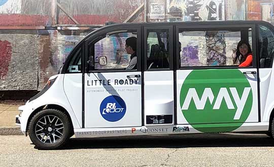
    Little Roady Shuttle to aid research on autonomous vehicle technology

    Rhode Island officials have kicked off the Little Roady autonomous vehicle pilot project in Providence. The research project, which aims to evaluate autonomous mobility technology, begins service May 15.

    The free service will be the focus of a research project to help the Rhode Island Department of Transportation (RIDOT) better understand the opportunities and challenges that come with integrating this new technology into its transportation planning. The research will help improve transit and provide information for communities, the workforce and policymakers.

    The shuttles use a suite of sensors — including some from Middletown-based KVH Industries — and intelligent software to help the vehicle understand its environment and how to safely navigate through it.

    The entire fleet has undergone 500 hours of testing both at Quonset Point this winter and in Providence this spring, which included detail mapping so the machines know every inch of its route and how to operate in a variety of traffic and weather conditions.

    The Little Roady shuttles are provided by May Mobility Inc., which entered into a public-private partnership with RIDOT in the fall of 2018, following a competitive request-for-proposals (RFP) process.

    “It’s always exciting when Rhode Island has an opportunity to lead the way in cutting-edge green technology,” said Governor Gina Raimondo. “This project will provide valuable data for states across the country as we move beyond conventional transit services to provide better, cleaner, and more accessible transportation for all.”

    The experimental service will operate seven days a week, from 6:30 a.m. to 6:30 p.m., with 12 stops between Olneyville Square and Providence Station. The Little Roady shuttles will run on a continuous, 5.3-mile loop on low-speed roads with an average wait time of about 10 minutes. Trip time will be about 20-25 minutes each way from Providence Station to Olneyville Square.

    “The kickoff of this service and research project is another achievement for the new DOT,” RIDOT Director Peter Alviti, Jr., said. “Our transportation agency has literally been rebuilt to effectively deliver safer roads and bridges while simultaneously studying and piloting new technologies. In doing so, we’ll keep Rhode Island well ahead of the curve for the transportation solutions of tomorrow.”

    “By partnering with RIDOT, May Mobility is showing how our self-driving shuttles can be part of a sustainable future for communities,” said Edwin Olson, CEO and founder of May Mobility. “Our environmentally-friendly shuttles aren’t just fun-to-ride, they can increase access and convenience for a large number of people.”

    The cost of the project, including the research component, is $1.2 million. This includes funding for an $800,000 public-private partnership with May Mobility, a $500,000 grant awarded by the R.I. Attorney General’s Office as part of a settlement with Volkswagen, federal research funds through the Federal Highway Administration, and matching state funds. RIDOT’s contract with May Mobility includes options to extend the service for an additional two years.

    The debut of the autonomous vehicles is the latest step in a multi-agency effort called the Rhode Island Transportation Innovation Partnership (TRIP), which RIDOT launched in 2017. TRIP also includes a research component, with the goal of studying autonomous mobility solutions, ridership, workforce impacts, environmental impacts, and technology adoption, among others.

    TRIP includes many partner agencies and governmental entities, including the City of Providence, the Rhode Island Public Transit Authority (RIPTA), the Rhode Island Division of Motor Vehicles and the Quonset Development Corporation. The research team is made up of representatives from Brown University, 3×3 Design, Stae, and Bits and Atoms.

    May Mobility, a Michigan-based startup, is developing self-driving shuttles for college campuses, corporate clients, and central business districts. It launched a private corporate service in Detroit in June 2018 and a public service in Columbus, Ohio, in December 2018. It has also entered into an agreement for public service in Grand Rapids, Michigan. The company has hired fleet attendants and managers from Rhode Island and has set up a local operations office in Providence.


    Featured photo: Rhode Island Department of Transportation (RIDOT).

  • Orolia SecureSync to synchronize FAA’s enroute radar systems

    Orolia SecureSync to synchronize FAA’s enroute radar systems

    Orolia, a provider of resilient positioning, navigation and timing (PNT) solutions, announced that its SecureSync time and synchronization servers have been selected to support enroute radar systems across the U.S.

    The selection comes as part of the Federal Aviation Administration’s (FAA) move towards a Next Generation Air Transportation System (NextGen). NextGen is about halfway through a multi-year investment and implementation plan.

    The FAA plans to keep rolling out NextGen technologies, procedures and policies through 2025/2030 and beyond.

    While NextGen will rely heavily upon GNSS to increase capacity, efficiency, and safety in the National Air Space (NAS), many technologies including legacies such as radar will be integrated into the system for maximum robustness to error and disruption.

    The FAA employs a variety of radar types for short-, medium- and long-range air traffic control requirements. These diverse radars require different types of timing signals and outputs to suit their operations.

    SecureSync. Orolia’s SecureSync provides the necessary timing outputs and signals to meet these requirements. The time server’s ability to provide resilient, accurate and reliable timestamps for the data that it receives from radars is used to quickly organize the data for the aircraft control user interface.

    The only time and synchronization device approved by the Defense Information Systems Agency (DISA) for use in U.S. Government networks, Orolia’s SecureSync provides reliability, security and flexibility to synchronize critical aviation operations. SecureSync combines multi-GPS/GNSS signal synchronization, options for alternative signals and BroadShield GPS anti-jamming/spoofing protection for transportation systems. SecureSync combines Orolia’s precision master clock technology and secure network-centric approach with a compact modular hardware design.

    The FAA selected Orolia for the competitive program based on its proven timing and synchronization technology and its ability to offer multiple output options as commercial off-the-shelf (COTS) products that do not require additional research and development time or investment.

    “Consistently accurate timestamps and the synchronization of thousands of real-time flight data points are essential for safe and efficient enroute air traffic operations,” said Jean-Yves Courtois, CEO of Orolia. “Orolia is proud to support the FAA’s radar data and aircraft control user interface requirements to improve air travel services nationwide.”

    More About the SecureSync COTS Product. Built-in time and frequency functions are extended with up to 6 input/output modules. Included with the base unit is a 1PPS timing signal aligned to a 10 MHz frequency signal without any 10 MHz phase discontinuity.

    A variety of internal oscillators are available, depending on requirements for holdover and phase noise. On-board clocks synchronize to a variety of external references as standard, factory-installed or upgradable options.

    Users may add alternate signals of opportunity to GPS or GNSS input references to improve resilience, or use them for indoor applications and choose from a variety of option cards to add to configuration of timing signals, including additional 1PPS, 10 MHz, time code (IRIG, ASCII, HaveQuick), other frequencies (5 MHz, 2.048 MHz, 1.544 MHz), telecom T1/E1 data rates, multi-network NTP and PTP. Modules can be customized for exact requirements.

    To support network time synchronization, SecureSync supports the latest features of network time protocol (NTP) and precision time protocol (PTP, IEEE-1588v2). An optional multi-port NTP configuration allows for operation across 4 isolated LAN segments. Up to 6 PTP ports can be added to operate in various PTP deployments.

    SecureSync is a security-hardened network appliance designed to meet rigorous network security standards and best practices. It ensures accurate timing through multiple references, tamper-proof management and extensive logging. Robust network protocols are used to allow for easy but secure configuration.

    Features can be enabled or disabled based on network policies. Installation is aided by DHCP (IPv4), AUTOCONF (IPv6), and a front-panel keypad and display. The 1 RU chassis supports multi-GNSS (GPS/ Galileo/GLONASS/BeiDou/QZSS) input.

    Options include SAASM, supporting L1/ L2, available for authorized users and required for the US DoD, and BroadShield GPS jamming and spoofing detection. The unit is powered by AC on an IEC60320 connector. DC as back-up, or primary, is available.


    Featured photo: Orolia

  • New u-blox module aimed at lane accuracy in urban areas

    New u-blox module aimed at lane accuracy in urban areas

    The ZED-F9K module is designed to keep cars in their lanes. (Photo: u-blox)
    The ZED-F9K module is designed to keep cars in their lanes. (Photo: u-blox)

    The new u‑blox ZED-F9K GNSS and dead-reckoning module is designed to bring continuous lane accurate positioning to challenging urban environments.

    The module offers both high-precision multi-band GNSS and inertial sensors. It combines the latest generation of GNSS receiver technology, signal processing algorithms and correction services to deliver down to decimeter-level accuracy within seconds, addressing the evolving needs of advanced driver-assistance systems (ADAS) and automated driving markets.

    The ZED-F9K builds on the u‑blox F9 technology platform. Compatibility with GNSS correction services further improves positioning accuracy by compensating ionospheric and other errors.

    The real-time kinematic (RTK) receiver module receives GNSS signals from all orbiting GNSS constellations. The greater number of visible satellites improves positioning performance in partially obstructed conditions, while increased satellite signals delivers faster convergence times when signals are interrupted.

    Inertial sensors integrated into the module constantly monitor changes in the moving vehicle’s trajectory and continue to deliver lane accurate positioning when satellite signals are partially or completely obstructed, as is the case when the vehicle is in parking garages, tunnels, urban canyons or forested areas.

    When satellite signals become available again, the module combines inertial sensor data with GNSS signals to deliver fast convergence times and high availability of the decimeter-level solution.

    The result of this combination of the latest developments in GNSS technology, correction services and inertial sensing is a tenfold increase in positioning performance over standard precision solutions, according to u-blox.

    By robustly providing lane accurate position information, the ZED‑F9K meets the needs of ADAS and autonomous driving applications, as well as head units and advanced navigation systems. The module’s accuracy and low latency also makes it suitable for automotive OEMs and Tier 1 automakers developing V2X (vehicle-to-everything) communication systems. By continuously sharing their location with other traffic participants, V2X systems contribute to increasing overall road safety and reducing traffic congestion.

    “We designed the ZED-F9K to be a turnkey high-precision GNSS solution that caters to the needs of today’s and tomorrow’s connected cars,” said Alex Ngi, product manager, product strategy for dead reckoning, u‑blox. “The ZED-F9K is unique in that it integrates a multitude of technologies, from the GNSS receiver to the inertial measurement unit and relevant dead reckoning algorithms into a single device for which we can ensure performance throughout the customer product development cycle.”

    Samples will be available upon request by July.

  • Trimble RTX Auto enables precision positioning for vehicles

    After 2020, Super Cruise will will be available on all General Motors brands (Photo: GM)
    After 2020, Super Cruise will will be available on all General Motors brands (Photo: GM)

    Trimble has announced the availability of Trimble RTX Auto, a GNSS software library written for use in safety critical automotive applications.

    The RTX Auto library can be integrated with any GNSS device and enables the decoding of Trimble’s RTX correction stream for centimeter-level absolute positioning accuracy, the company said.

    RTX Auto works with other on-vehicle sensors to deliver a positioning solution that satisfies advanced driver assistance systems (ADAS) and autonomous driving requirements.

    RTX Auto is both Automotive Safety Integrity Level (ASIL) and Automotive Software Process Improvement and Capability Determination (ASPICE) certified. These certifications validate that Trimble RTX Auto meets functional safety requirements for ADAS and autonomous applications in the auto industry.

    “For over 35 years, Trimble has been at the forefront of positioning innovation, accelerating productivity for our users,” said Patricia Boothe, vice president of Trimble’s Advanced Positioning Division. “RTX Auto takes our technology leadership into functional safety applications and allows the automotive industry to leverage Trimble’s leading RTX correction technology. Trimble RTX technology is helping to safely accelerate vehicle autonomy, transforming how the world drives.”

    While other correction service providers are validating their ADAS positioning products and services in test environments only, Trimble is on the road today providing RTX-based absolute positioning within General Motors’ Super Cruise, a hands-free driving system for the freeway.

  • CHC Navigation launches P2 GNSS sensor series

    CHC Navigation launches P2 GNSS sensor series

    Designed for demanding positioning and heading applications

    The P2 Elite GNSS sensor. (Photo: CHC Navigation)
    The P2 Elite GNSS sensor. (Photo: CHC Navigation)

    CHC Navigation has released the P2 GNSS sensor series, which the company says provides high-accuracy positioning and heading in a compact, rugged enclosure.

    The P2 GNSS sensor series is suitable for a wide variety of applications such as reference station, marine systems, unmanned navigation, industrial automation, robotics and machine control.

    Integration. The P2 GNSS series is designed to significantly reduce system integration efforts by combining numerous connectivity interfaces including RS232, low-latency PPS output, Ethernet, CAN bus protocol and a comprehensive web interface for configuration set-up.

    The series integrates the latest GNSS technology in an extremely rugged IP67 and lightweight enclosure. It delivers reliable, uninterrupted, high-accuracy, real-time positioning and heading measurements.

    Scalable with 3 models. The P2 GNSS series is available in three different models to match various application requirements.

    • The P2 GNSS sensor offers cost-effective and powerful real-time kinematic (RTK) positioning.
    • The P2 Pro GNSS adds a dual-antenna input for precise heading data.
    • The P2 Elite integrates additional 4G and UHF modems to provide a powerful, all-in-one, GNSS sensor.

    “The P2 GNSS sensor series is leveraging our expertise in providing high-performance and reliable GNSS solutions,” said George Zhao, CEO of CHC Navigation. “Back-up by CHCNAV’s professional integration support, the P2 GNSS sensor series offers exceptional feature set to system integrators and machine manufacturer partners.”