Completion of the transaction was subject to regulatory approvals, including a filing to the Committee on Foreign Investment in the United States (CFIUS), which have now been obtained.
AutonomouStuff will be a fully owned subsidiary of Hexagon and operate within Hexagon’s Positioning Intelligence division.
“Combined with Hexagon PI’s leadership in high accuracy, functionally-safe and high-integrity positioning technology, the addition of AutonomouStuff and their offerings is helping our customers to accelerate the development of more comprehensive Autonomous X solutions,” said Michael Ritter, president and CEO of Hexagon PI. “Our expanded capabilities will allow Hexagon PI to meet the industry’s ever growing demand for more robust autonomy solutions.”
Hexagon PI has been an important technology provider to AutonomouStuff for several years, and the two organizations have worked closely together to serve common customers and collaborate on important industry events. As the division grows, AutonomouStuff will continue to function as an independent brand within Hexagon PI.
Founded in 2010, U.S.-based AutonomouStuff is pioneering solutions and platforms for autonomous vehicle development, robotics and data intelligence innovation. Its platforms, which use an expansive portfolio of technologies, are deployed in pilot programs worldwide — representing thousands of customers in the automotive and technology sectors across the globe, AutonomouStuff said.
“The combined entities now provide the fuel and support for exponential growth while affording us the ability to make continued advances in the mobility space,” said Bobby Hambrick, founder and CEO, AutonomouStuff. “I’m very excited for our shared future.”
In 2017, AutonomouStuff generated sales of 45 MUSD, with good profitability, Hexagon said. The AutonomouStuff transaction purchase price will not be publicly disclosed because it is considered insignificant relative to Hexagon’s market capitalization.
The income statement during the third quarter of 2018 will be impacted by -25 MEUR, related to impairment of overlapping technologies, transaction costs and a reduction in workforce. During the third quarter 2018 Hexagon also divested its shares in Bimobject which resulted in a capital gain of 22 MEUR.
Overall, the net impact of one-off items on the income statement in the third quarter 2018 will be approximately -3 MEUR, Hexagon said.
VBOX indoor positioning beacon atop a car. (Photo: Racelogic)
Racelogic demonstrated a new VBOX solution for accurate position and velocity in the absence of any GNSS signals, such as indoors, at the ION GNSS+ exhibition.
VBOX data acquisition systems are used for measuring the speed and position of a moving vehicle. Based on a range of high-performance GPS receivers, VBOX dataloggers can record high-accuracy GPS speed measurements, distance, acceleration, braking distance, heading, slip angle, lap times, position, cornering forces and more.
VBOX indoor positioning beacon in a bracket. (Photo: Racelogic)
The new VBOX Indoor Positioning System consists of a network of fixed beacons communicating with a small receiver mounted on the roof of the vehicle, which is connected to an existing VBOX. The receiver computes its position 100 times a second to around 5 centimeters real-mean-squared (RMS) accuracy. The system can be used on its own or with an internal inertial measurement unit (IMU) to improve the velocity accuracy.
Racelogic engineers worked closely with its VBOX customers to develop a solution that allows the same test equipment and software that has traditionally been limited to outdoor use to be used anywhere that satellites coverage is limited or completely unavailable, such as in a parking garage.
Beacon placement. (Image: Racelogic)
The VBOX seamlessly switches between outdoors and indoors, allowing testing to continue whatever the environment and VBOX users to make use of their original hardware and software applications.
Racelogic will demonstrate the system at the ION GNSS+ exhibition at the Hyatt Regency in Miami, Sept. 26-27. Racelogic will also be showcasing its new, upgraded version of SatGen simulation software for the Labsat 3 Wideband simulator.
A new GPS + IRNSS module is being developed by Indian firm Ramakrishna Electro Component (REC) in partnership with STMicroelectronics and Shanghai Mobiletek, according to press reports.
The module will rely heavily on the Indian navigation satellite constellation IRNSS (also known as NaVIC), REC Managing Director Shivang Luthra told reporters at an event in New Delhi.
“There have been dependency of imported GPS module which use the U.S., European or Russian satellites,” Luthra said. “We have developed a GPS module, Utraq, that will mainly use the Indian satellites for GPS navigation.”
The module will be produced at a Shanghai Mobiletek factory in China, and the chips will be made by STMicroelectronics. REC owns the Utraq module and will roll it out in October for use in automotive end products. REC says the low cost of the chip compared to imports will make trackers more affordable in India.
The Indian government has mandated use of vehicle location tracking devices and one or more emergency buttons in public transportation vehicles; the mandate took effect April 1.
Utraq will be offered in two models: the L110 GNSS is a compact NavIC module, while the L100 GNSS module is a smaller-sized (patch on top) IRNSS module. Both modules can be used for tasks other than tracking, such as ranging, command, control and timing, and fo marine, aerial and terrestrial navigation.
This announced version of Qualcomm Technologies’ precise positioning framework supports single-frequency GNSS utilizing real-time kinematic (RTK) technology based on the GNSS receiver built into Qualcomm Snapdragon LTE modems and Qianxun SI’s precise positioning technology — all integrated in an automotive-grade LTE module provided by Quectel.
Using Qualcomm 3D dead-reckoning technology, the precise-positioning framework will enable automakers with a comprehensive 3D navigation solution combining multi-constellation GNSS precise positioning, inertial measurement units and other sensors to support next-generation vehicle capabilities, the companies said.
Capabilities include high-performance connected navigation as well as LTE-V2X vehicle-to-everything communications (also referred to as C-V2X PC5 across the globe) for enhanced road safety, improved traffic efficiency and autonomous driving.
Qualcomm Technologies’ precise positioning framework is designed to facilitate open-sky positioning performance from up to 3 meters to less than 1 meter, supporting lane-level positioning and potentially achieving accurate locations from a centimeter to a few decimeters when combined with select third-party GNSS correction services.
This framework is also designed to support a safer and convenient automated driving experiences (level 2 and above), as well as LTE-V2X applications based on positioning, velocity and heading information. Integrated into telematics modules based on the Snapdragon LTE modems, the precise positioning framework supports a cost-effective solution for automakers already including cellular connectivity into their vehicles.
“The efforts with Qualcomm Technologies and Quectel not only assists automakers in addressing the cost and complexities of integrated precision positioning services, but it also aids in creating hardware and service standards for the industry to promote this capability as a public service in the field of connected cars,” said Jinpei Chen, CEO of Qianxun SI. “We look forward to working with Qualcomm Technologies and Quectel to help deliver a solution for higher accuracy and positioning, particularly in dense environments such as in China.”
“In efforts to meet the positioning service requirements of mainstream automakers and Tier 1 suppliers, we felt that working with technology leaders like Qualcomm Technologies and Qianxun SI would be the best to deliver an intelligent, cost-effective and high-quality telematics module,” said Penghe Qian, CEO of Quectel. “The AG35 is our newest generation of automotive-grade modules that enables 4G connectivity and lane level positioning simultaneously, allowing the adoption of LTE-V2X and HD Map technologies on a broad scale.”
“The automotive industry is becoming increasingly dependent on high performance positioning technologies to support connected navigation, safety services and vehicle autonomy,” said Nakul Duggal, vice president of product management, Qualcomm Technologies, Inc. “At Qualcomm Technologies, our proven positioning and system integration capabilities, along with Quectel and Qianxun SI’s solutions, can provide customers with cost-effective precise positioning solutions. We are pleased to be working with China’s leading technology companies like Quectel and Qianxun SI to advance next-generation automotive capabilities that will drive the automotive industry forward.”
PCTEL Inc. will demonstrate its next generation of multi-band, multi-network 4G LTE antennas at InnoTrans 2018 for the transit and rail industries, which takes place Sept. 18-21 in Berlin.
PCTEL’s new Trooper II and Coach II dual-carrier antenna platforms are designed to meet the requirements of increasingly complex RF communication systems in transportation applications.
The Trooper II antenna. (Photo: PCTEL)
Both Trooper II and Coach II antennas feature four 4G LTE antenna elements, and four 802.11ac Wi-Fi MIMO elements compatible with the world’s leading multi-network cellular routers.
The antennas support carrier aggregation for high-speed data transmissions in dense RF environments, such as transit depots and rail stations.
They also incorporate PCTEL’s proprietary high-rejection multi-GNSS technology for high precision tracking and asset management. Both platforms are housed in attractive low-profile housings and can be easily installed on all types of mass transit vehicles, or even fixed surfaces, the company said.
“PCTEL has a strong portfolio of products for rail and mass transit applications,” said Rishi Bharadwaj, PCTEL’s COO. “Our products have been qualified and deployed by major railroad equipment manufacturers and operators for over a decade. We are excited to showcase our industry-leading technology and capabilities at InnoTrans.
“High-performance antennas play a crucial role in the implementation of wireless technologies to improve safety and operational efficiency,” Bharadwaj said. “PCTEL’s innovative MIMO antenna technology also enables transit operators to deliver a better passenger experience through more reliable high-speed internet access.”
By Sam Pullen, Stanford University; Jim Kilfeather, Jim Goddard, Tom Nowitzky, Brinda Shah, Wen Doong, David Kagan, and Kerry Greer, Globalstar. To be presented at ION-GNSS+ 2018.
Globalstar is developing a connected car program for continuous, worldwide service to vehicles via satellite and terrestrial communications links.
This combines PPP corrections provided globally by the second-generation Globalstar low-Earth orbit (LEO) constellation with local-area corrections via LTE cellular signals in urban areas for connectivity anytime, anywhere. Both signals are broadcast at 2.4 GHz and include pilot channels used for ranging, augmenting GNSS ranging and providing robustness against jamming and spoofing.
The program provides enhanced navigation via continuous augmentation of GNSS with data derived from ground-based reference networks for sub-meter accuracy and integrity bounds on navigation errors to probabilities as low as 10-9 per operation. When this is combined with other on-board sensors and data such as lidar, radar, optics and IMUs, it will be possible to operate autonomously under almost all conditions with a very high degree of safety.
The key is combined use of PPP corrections globally and local-area CDGNSS/RTK corrections in high-density urban regions where it is economically beneficial. Both sets of augmentations are made available to vehicles. The global approach on the left side of the figure is primary, given its near-worldwide coverage based on the LEO satellite network broadcasting corrections within its licensed communications spectrum at 2.4 GHz. The P/N-modulated pilot component of the Globalstar satellite signals will be used for ranging to augment GNSS and provide additional robustness to RF interference or spoofing at GNSS frequencies.
A roundup of recent products in the GNSS and inertial positioning industry from the September 2018 issue of GPS World magazine.
OEM
Reference receiver
For real-time networks (RTN)
Photo: Trimble
The Trimble Alloy GNSS reference receiver is designed for continuously operating reference stations (CORS). It offers 672 channels and constellation tracking of GPS, GLONASS, BeiDou, Galileo, QZSS, IRNSS and SBAS for robust and reliable reference data. With an IP68 rating for protection against dust and moisture, the Alloy performs in rugged environments to meet the demands of professionals in earth science, surveying, construction, mapping and agriculture. The Alloy allows RTN owners and operators to track and log all current and planned GNSS and deliver absolute position monitoring, as well as centimeter-level accuracy in real time with Trimble RTX precise point positioning technology. Featuring a four-line OLED screen, the receiver displays key information without the need to scroll through multiple menus. Other features include dual hot-swappable batteries, multiple power inputs and serial ports, Wi-Fi connectivity and remote access options.
The TW7875 magnetic-mount GNSS antenna is designed for precision dual-frequency positioning. It is capable of receiving GPS L1/L5, GLONASS G1, BeiDou B1, Galileo E1/E5a and NavIC L5. It employs Tallysman’s Accutenna technology, which provides superior multipath signal rejection due to its low axial ratio across the full bandwidth. It also provides a linear phase response and tight phase-center variation. It is designed for precision agriculture, autonomous vehicles and other precision applications. The TW7875 is housed in a magnetic-mount IP67-rated housing, but can also be mounted with screws or adhesive tape. The embedded version, Model TW3875, has a wide selection of connectors and custom cable lengths, and can be custom tuned by Tallysman to ensure optimum performance within the customer’s enclosure.
The SPAN CPT7 provides tightly coupled GNSS+INS navigation technology in a rugged, compact unit. Commercially exportable and designed for integration into a wide variety of applications, it delivers assured positioning anywhere. SPAN technology tightly couples GNSS and inertial navigation system (INS) measurements. The system enables continuous, robust positioning and fast reacquisition in challenging navigation environments where GNSS signals may be unreliable or unavailable for short periods. Dual antennas deliver instant alignment. NovAtel’s OEM7 Interference Toolkit (ITK) provides interference detection and mitigation, with the spectrum analysis function allowing integrators to identify interference within the GNSS frequency bands and implement digital filters to eliminate the problem.
The commercial-off-the-shelf (COTS) LN-200C is a compact and lightweight six-degrees-of-freedom inertial measurement unit (IMU) that can be used for instrument stabilization, motion compensation and navigation in commercial, aerospace and industrial applications. Based on fiber-optic gyro (FOG) technology, the LN-200C IMU’s hermetic seal and lack of moving parts help to ensure low noise and extended operational life. The LN-200C can serve as a drop-in replacement for applications that don’t require the full operational range of the original LN-200 and that can benefit from the expedited licensing and global ease of use offered by the LN-200C.
Global Certification Forum (GCF) protocol conformance tests available
Photo: Rohde & Schwarz
The Rohde & Schwarz CMW500 wideband radio communication tester and SMBV100A GNSS simulator have been expanded to support Global Certification Forum (GCF) protocol conformance tests for C-V2X device certification. Utilizing the Qualcomm 9150 C-V2X chipset from Qualcomm Technologies, the R&S CMW500 acting as an LTE network simulator allows automakers to test C-V2X direct communications (PC5) according to GCF Work Item 281. The new R&S CMW-KK550 test package includes the 3GPP Protocol Conformance tests from LTE-V2V GCF Work Item 281 and LTE-V2X GCF Work Item 282. The R&S CMW-KU514 C-V2X software package on the R&S CMW500 is used to verify data transmission and reception over the PC5 interface in ideal, faded and congested channel conditions. Together, both packages enable Rohde & Schwarz to support C-V2X device testing through all protocol layers.
The Multimax FV family is available in a range of configurations, supporting multi-constellation GNSS. The antennas also support up to dual MIMO LTE (including Band 14 for the FirstNet public safety network), 3×3 MIMO Wi-Fi or 2×2 MIMO Wi-Fi. With a small footprint and a strong, bolt-mount aluminum base, the Multimax FV family provides protection against natural hazards threatening vehicles, including vibration, ice, salt, car washes and tree sweeps. The high-gain antennas deliver a large cellular footprint alongside high-rejection GNSS technology (GPS, GLONASS, Galileo and BeiDou).
For Beyond Visual Line-of-Sight (BVLOS) flight operations
Arctic UAV has adopted Kongsberg Geospatial’s IRIS UAS Airspace Awareness application for BVLOS operations within Canada’s Arctic. IRIS provides simultaneous monitoring of multiple drones. It offers real-time calculation of aircraft separation and communications line-of-sight, real-time visualization of track and weather data.
M.A.D.S detects and identifies commercial drones within a 5+ kilometer range, providing GPS positioning of both drone and pilot together with the drone’s speed and heading. Once a drone threat is established, the system enables a 500-meter electronic exclusion zone to be created around the yacht. Should the drone approach this exclusion zone, its control/video signal is blocked, initiating a fail-safe mode and forcing a landing or return to operator.
Operates on the Wave Relay mobile ad hoc network (MANET)
The Auto-Tracking Antenna System is a portable ground-to-air antenna for tracking aircraft, including drones. Defense customers can use it for better airborne communications relay and full-motion video camera/sensor data transmission. It can be assembled and deployed in less than 15 minutes.
Version 6 of Virtual Surveyor drone surveying software offers a faster, more efficient workflow and better user experience in a more stable platform than previous versions. Along with new capabilities is an improved licensing system and an extended free application. The software generates an interactive onscreen environment through orthophotos and digital surface models generated from a UAV, where the surveyor selects survey points and breaklines to define the topography. It enables land surveyors to complement traditional fieldwork with UAV imagery to generate highly accurate topographic products.
Foresights is a risk management and geospatial analytics platform designed to help clients manage forestry assets quickly, effectively and accurately. Foresights identifies areas of new or potential risk, and delivers operations tracking and forest damage management services. It combines satellite imagery, topography maps, soil maps, meteorological data and near real-time ground input from operational teams to deliver optimized insights. It can detect damage as small as 0.1 hectare (0.25 acre) from pests, disease and drought.
EOS Platform provides a powerful toolset for geospatial analysts — offering search, analysis, storing and visualization of large amounts of geospatial data. Image data obtained from LandViewer or uploaded from a user’s computer is stored in cloud-based EOS Storage and is instantly available for remote-sensing analysis or image processing. EOS Processing offers 16 workflows that run online, including raster tools, remote sensing analytics, photogrammetry and proprietary feature extraction algorithms designed by EOS engineers and data scientists to address the main challenges of agriculture, forestry, oil, gas, retail, city planning, defense and other industries.
The Esri book GIS for Surface Water: Using the National Hydrography Dataset by Jeff Simley details how to use geographic information system (GIS) technology to visualize and analyze data sets. Simley is an award-winning cartographer and the former lead of the hydrography program at the United States Geological Survey (USGS). The book examines the complexities of surface water systems and shows readers how to use the Esri ArcGIS software with government water data sets to better study and manage the United States’ vast water system.
EOMAP has opened a commercial online store for global shallow-water bathymetry derived from satellite data. At the store, EOStore Bathymetry, customers can search for and request high-quality data. Satellite-derived bathymetry (SDB) is a valuable tool for the surveying, planning and management of coastal and offshore sites. SDB can provide shallow-water bathymetric data worldwide without the need for a physical presence in the area of interest. EOMAP developed the bathymetry store in response to industry feedback. EOStore Bathymetry offers different horizontal spatial resolutions of the bathymetric grid of 2 to 15 meters, making the data suitable for surveying as well as planning and modeling purposes.
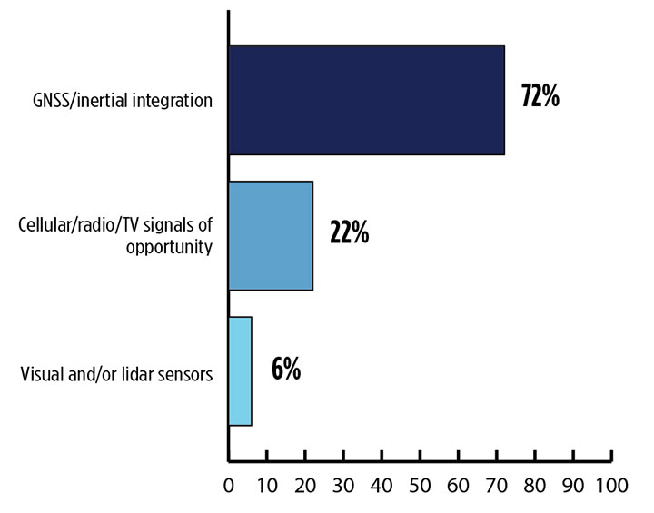
Signals other than GNSS are the key to positioning for both the transportation and machine control markets. While many solutions are being developed, inertial navigation systems (INS) are emerging as the primary GNSS co-star.
In our survey, nearly three quarters (72%) of respondents in this sector said positioning could best rely on tight integration between GNSS and INS. For comparison, inertial technology wasn’t even mentioned in the 2017 State of the GNSS Industry Report. This year for the first time, GPS World offered an Inertial Buyers Guide for our readers (see our May issue).
What is the best additional solution for positioning in GPS/GNSS-challenged environments? (Source: GPS World 2018 State of the GNSS Industry survey)
Practical autonomous navigation — the current ambition of automakers (and Google) — hits a roadblock when it comes to uninterrupted positioning. We all know GNSS reception has its limits, notably in many places that vehicles travel such as tunnels, beside tall buildings and in parking garages. Inertial positioning fills that gap, making it especially advantageous for meeting the challenges of autonomous navigation.
Inertial measurement units are generally based on multi-axis combinations of precision gyroscopes, accelerometers and magnetometers using algorithms to determine location, direction and position. Gyroscopes measure the angular velocity; accelerometers measure overall acceleration; and magnetometers provide the direction of the magnetic field.
Micro-electro-mechanical (MEMS) techniques have reduced the size, power consumption and costs of INS systems considerably, enabling their use in ever more applications, including unmanned aerial vehicles.
As a result, products that combine GNSS + INS are being introduced at an increasing rate, with more than a dozen major announcements in the past year. According to one study, the INS market is projected to grow from US$11.89 billion in 2017 to US$19.67 billion by 2023, a compound annual growth rate of 8.76%.
For more results from the 2018 State of the GNSS Industry, see this page.
Conducted online in July 2018, the GPS World State of the GNSS Industry survey compiled detailed answers to 30 key questions from 273 respondents, spread across six continents.
Prominent insights gained, and outlined in these pages: the PNT sector is booming, as opportunities outnumber obstacles; well-trained engineers are at a premium; and the Internet of Things is the newest market driver, perhaps the most powerful yet.
If you’ve taken a flight in Europe recently, then the chances are growing that you’ve been a pioneer EGNOS user. Satellites in orbit would have guided your airliner’s descent, rather than signals beamed from the ground. You wouldn’t have felt any difference — except for possibly a smoother ride.
Cockpit of a new EGNOS-equipped Airbus 350 XWB, on show during the inaugural EGNOS Day at Toulouse-Blagnac Airport on May 7, 2015. (Photo: ESA)
More than 180 European airports have now been certified to make use of the ESA-designed European Geostationary Navigation Overlay Service — EGNOS — for approaches to given runways. This includes approaches at major hubs such as Paris Charles de Gaulle, Frankfurt and Amsterdam Schiphol. Thanks to EGNOS, safe landings would still be possible even if an airport were shut down entirely.
Sharpening the precision of GPS satnav signals over most European territory, EGNOS was designed to make satnav reliable enough for safety-critical aviation employment, but has found a wide range of other uses, from agriculture to road, rail and maritime transport.
An EGNOS app is available from the Apple and Google Play stores, offering easy access to all EGNOS-related information, including the different EGNOS services, official documentation, historical and current performance data, support material and contact with the 24/7 EGNOS helpdesk.
An EGNOS V3 Ranging and Integrity Monitoring Station (RAIMS) being tested at the Santiago de Compostella site in Spain, designed and manufactured by Thales Alenia Space in Italy. (Photo: ESA)
EGNOS is based on a network of monitoring stations across Europe that perform independent measurements of GPS signals, so that corrections can be calculated to boost satnav positioning performance. These results are passed to users immediately via a trio of geostationary satellites.
The service is allowed just a one in 10 million chance of error. If this tolerance is exceeded, EGNOS users are informed within six seconds. The result is that EGNOS-augmented signals meet the extremely high performance standards set out by the International Civil Aviation Authority, adapted for Europe by Eurocontrol, the European Organisation for the Safety of Air Navigation.
EGNOS operations are the responsibility of the European Global Navigation Satellite System Agency (GSA) of the European Commission and run by the ESSP, European Satellite Services Provider.
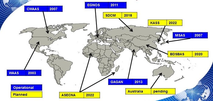
EGNOS is the European equivalent of the U.S. Wide Area Augmentation System (WAAS), which was the world’s first satellite-based augmentation system. The U.S. and European systems have been carefully designed to work together seamlessly.
Additional equivalent regional systems, fully interoperable with the existing ones are either in operation (Japan, India, Canada) or in definition or development (Russia, China, South Korea, West Africa and Australia).
Satellite-based augmentation systems worldwide. (Image: ESA)
Through the LPV-200 procedure, short for “localizer performance with vertical guidance 200 feet,” signals from space guide pilots through any weather down to within just 60 meters (200 feet) of the runway, at which point they make visual contact with the ground for a final go/no go landing decision.
EGNOS offers all-weather access to all certified runway approaches — each side of a runway requiring its own, separate, certification — without the need for expensive ground Instrument Landing System infrastructure. Satellite-based landing approaches can also be tailored to be smoother and more fuel-efficient.
Smaller airports unable to afford ground instrumentation draw the greatest benefit. Employing EGNOS means they get to operate in all weather conditions.
ESA retains the lead role in the future development of EGNOS, working with Thales Alenia Space and Airbus Defence and Space and their subcontractors to design, develop, deploy, and validate and test the new design elements.
While the current system is solely reliant on GPS, the next-generation EGNOS V3 will combine the use of GPS with Europe’s own Galileo satnav system to boost EGNOS accuracy and reliability still further. It is planned to enter service around 2025.
The Korea Research Institute of Ships and Oceans Engineering (KRISO) has awarded UrsaNav a contract to supply an eLoran Transmitter Test Bed System in the Republic of Korea.
UrsaNav, the exclusive, worldwide distributor of Nautel’s NL Series transmitters, will provide eLoran transmitter technology, as well as timing and control equipment.
A meeting to kick off the eLoran work. (Photo: UrsaNav)
The contract, awarded through UrsaNav’s agent Dong Kang M-Tech, represents the first phase in a broader program to upgrade Korea’s Loran-C stations to be the foundation of a sovereign Enhanced Loran (eLoran) positioning, navigation and timing (PNT) service.
The Republic of Korea recognizes the challenges associated with relying solely on space-based signals, the relative ease with which those signals can be jammed or spoofed, and the necessity to provide trusted time and position to its citizens and critical national infrastructure, UrsaNav said in a press release.
The press release also included the following description of the importance of eLoran.
Accurate time and position are necessary components upon which many critical infrastructure sectors rely, including maritime, aviation, electrical distribution, telecommunications, finance/banking, and digital broadcast. A complementary PNT (CPNT) service provides continuity of operations through alternative and diverse timing and positioning information. CPNT is a vital element in ensuring national security and assuring Trusted Time and Trusted Position.
eLoran is the latest in the longstanding series of low-frequency (LF), LOng-RAnge Navigation (LORAN) systems. It meets the accuracy, availability, integrity, and continuity performance requirements for maritime harbor entrance and approach maneuvers, aviation En Route and Non-Precision Approaches, land-mobile vehicle navigation, and location-based services. It provides bearing (azimuth) information, even when the user is not moving, and has built-in integrity. Users within the coverage area can simultaneously synchronize their timing to absolute (not relative) UTC. Of equal importance is that the eLoran signal includes one or more Loran Data Channels that are available to provide one-way, low data rate, “Short Message Service” information.
eLoran is completely independent of GPS/GNSS, operates in the internationally protected 90 to 110 kHz spectrum, is built on internationally standardized Loran-C, and provides a high-power PNT service for use by all timing and navigation users. SAE International expects to release eLoran standards this year. The RTCM also has maritime-related eLoran standards underway.
eLoran is a key vertex of a Resilience Triad that would typically include space-based, terrestrial, and at least one other PNT source. It is a very-wide area (i.e., country-wide or “continental”) source of PNT that continues providing a resilient solution even when GNSS may be unavailable or untrustworthy. eLoran delivers information comparable to that of GNSS, but with completely different phenomenology. It is a very high-power, LF, pulsed transmission, whereas GNSS are low-power, UHF, multiple modulation scheme transmissions. eLoran is literally at the other end of the spectrum from GNSS, and has completely dissimilar failure modes. That is, an issue that disrupts GNSS is unlikely to disrupt eLoran. The unique characteristics of eLoran enable its use in environments where GNSS does not work very well, or at all (e.g., indoors, underwater, underground, and in mountain or urban canyons).
eLoran is exceptionally difficult to spoof or jam, and it is nearly impossible to do so at a distance. Just as equipment required to spoof and jam GNSS must mimic relatively low powered GNSS transmissions, spoofing and jamming eLoran requires very high powered transmissions. Equipment needs alone to disrupt eLoran over a significant area would be almost prohibitive for any actor other than a nation state engaged in open conflict. This is the reason that an independent assessment by researchers at Stanford University described eLoran as “for all practical purposes, unjammable” across any significant area. A MITRE paper concluded: “The analysis shows a very low probability of successfully producing operationally significant interference.”
The Federal Railroad Administration (FRA) awarded $203,698,298 in grant funding for 28 projects in 15 states to assist with the deployment of positive train control (PTC) systems.
The $203 million in grants is part of the total $250 million specifically appropriated under the Consolidated Appropriations Act of 2018 for the implementation of PTC systems, via the Consolidated Rail Infrastructure and Safety Improvements (CRISI) program.
“These $200 million in grants will help the railroads continue to implement positive train control, a technology that could help reduce accidents and save lives,” said U.S. Transportation Secretary Elaine Chao.
The awards fund many aspects of PTC system implementation for intercity passenger or commuter rail and freight rail transportation, including back office PTC systems; wayside, communications, and onboard PTC system equipment; personnel training; PTC system testing; and interoperability.
Second-quarter PTC data
In addition, FRA released its second-quarter update on railroads’ self-reported progress toward implementing PCT systems. As of June 30, 15 railroads have installed 100 percent of the PCT system hardware that must be installed for implementation, based on a review of the railroads’ PTC Implementation Plans and quarterly progress reports for the second quarter of 2018. Twelve other ailroads have installed between 95 and 99 percent of the PTC system hardware identified in their PTC Implementation Plans.
According to FRA, this marks improvement from December 2016, where freight railroads had PTC active on just 16 percent of required tracks, while passenger railroads were at 24 percent.
In addition, second quarter data shows a 25 percent drop in the number of “at risk” railroads from 12 to nine. FRA considers any railroad that installed less than 90 percent of its PTC system hardware as of June 30 to be at risk.
“The railroads have achieved some significant improvements over the past year implementing this safety technology,” said FRA Administrator Ronald Batory. “While we are seeing progress among a majority of railroads, we want to see everyone meet their requirements.”
Awards Granted
When choosing the recipients of the grants, the FRA considered a number of factors, including supporting economic vitality; leveraging federal funding; using innovative approaches to improve safety and expedite project delivery; and holding grant recipients accountable for achieving specific, measurable outcomes.
Under the CRISI Program, at least 25 percent of funds are available for rural projects, the FRA said. In addition, federal funds awarded for CRISI grants must not exceed 80 percent of the total cost of a project, and the required 20 percent non-federal share may be composed of public sector (state or local) or private-sector funding, or both.
Agencies that received grants are:
Alaska Railroad Corporation
California Department of Transportation
Peninsula Corridor Joint Powers Board
Sonoma-Marin Area Rail Transit
Southern California Regional Rail Authority
Florida Department of Transportation
Iowa Interstate Railroad
Iowa Northern Railway Company
Belt Railway Company of Chicago
Chicago Rail Link
Commuter Rail Division of the Regional Transportation Authority
Chicago South Shore & South Bend Railroad
Northern Indiana Commuter Transportation District
Massachusetts Bay Transportation Authority
Springfield Terminal Railway Company (ST)/Pan Am Railways