The U.S. Air Force finally made it official and confirmed the rumor mill: Lockheed Martin has beat out rival satellite contractor Boeing for the contract to build the first eight GPS III satellites.
Secretary of the Air Force Michael Wynne and the Global Positioning Systems Wing, Space and Missile Systems Center, Los Angeles Air Force Base, Calif. made the announcement regarding the GPS III development and production contract late Thursday, May 15. In retrospect it was not exactly a well-kept secret; rumors had swirled for at least a month if not longer that Lockheed would get the nod, and two days earlier on May 13 the Wall Street Journal reported as fact that Lockheed had won, citing unnamed sources.
Under the $1.4 billion contract, the team of Lockheed Martin Space Systems Co., ITT Corp., and General Dynamics will produce eight GPS IIIA satellites, with the first launch projected for 2014, Lockheed said. The development contract will result in approximately 500 new jobs for Lockheed Martin.
Eight GPS IIIB and 16 GPS IIIC satellites are planned for later increments, with each increment including additional capabilities based on technical maturity. Taken as a whole, all of the GPS III contracts could be worth more than approximately $3.5 billion. When fully deployed, the GPS III constellation will feature a cross-linked command and control architecture, allowing the entire GPS constellation to be updated simultaneously from a single ground station, according to Lockheed. Additionally, a new spot beam capability for enhanced military (M-Code) coverage and increased resistance to hostile jamming, as well as new civilian signals, will be incorporated.
Lockheed Martin of course isn’t new to the GPS program; it designed and built 21 GPS IIR satellites for the Air Force and subsequently modernized eight of those spacecraft, designated GPS IIR-M. For GPS III, Lockheed Martin’s program management and spacecraft development effort will occur at its facilities in Newtown, Penn., with final assembly, integration and test located in Denver, according to the company. Its Sunnyvale, Calif., operations will provide various spacecraft components and a launch support team will be based at Cape Canaveral, Fla. Lockheed Martin’s flight-proven A2100 bus will serve as the GPS III spacecraft platform.
ITT, based in Clifton, N.J. will provide the navigation payload, and General Dynamics Advanced Information Systems, Gilbert, Ariz., will provide the Network Communications Element (NCE) which includes the UHF Crosslink and Tracking Telemetry & Command (TT&C) subsystems.
Oxford Technical Solutions (OxTS) has rolled out its Inertial+, an inertial navigation system that can be used with an existing GPS receiver to improve position measurements, according to the company.
The Inertial+ includes inertial sensors, processing engine, and algorithms. It is built around a 6-axis inertial measurement unit — including three angular rate sensors (gyros) and three servo-grade accelerometers — to measure position and velocity even when GPS is not available, OxTS said.
Designed for surveying in an urban environment, the Inertial+ is able to ignore or correct jumps in the GPS measurements. In addition to position data when combined with a GPS receiver, the device will also produce measurements like roll, pitch, and heading. Data is read and output in NMEA format, and other formats are supported. By combining an Inertial+ with a high-accuracy real-time kinematic (RTK) GPS receiver, users can achieve 1 centimeter precision, 0.03 degrees roll/pitch accuracy, and low drift rates when GPS is not available, according to the company.
Raytheon Co. has won a $61 million U.S. Air Force contract from the GPS Wing to complete the development and certification of next-generation GPS receivers.
Under the Modernized User Equipment (MUE) program, circuit card technology will connect military users with new GPS navigation signals used in forthcoming enhanced GPS satellites. The receivers, which will be able to read the new M-code military signal, also will work effectively with legacy signal systems, Raytheon said.
“The MUE program is raising the capability of military GPS equipment while lowering the cost for the warfighter,” said Phil Kelton, MUE program manager for Raytheon’s GPS and navigation systems business. “Raytheon’s approach to MUE takes advantage of breakthroughs in microelectronics technology, coupled with advanced security solutions to enable higher performance and greater integrity at less cost than today’s systems.”
Kelton sees potential to achieve “true force-enhancing status” for military GPS capability though the proliferation of low-cost GPS modernized user equipment, according to the company. Raytheon is teamed on the program with General Dynamics and Trimble Navigation Systems.
“The award of this second phase of the systems design and development contract allows us to complete the custom building-blocks being developed for the next-generation M-code GPS receivers,” said Michael Crisp, director of Raytheon GPS and navigation systems. It is developing two different form factors for receiver cards; this will allow modular upgrades of Raytheon’s avionics, weapons and integrated sensor systems ahead of the full deployment of the GPS III satellite constellation, Crisp said.
In December of last year the U.S. Air Force also exercised a $50.7 million contract option with another contractor, Rockwell Collins, to complete part of the next phase of the MUE program. That work consists of receiver card development for ground and airborne applications, including test and security certification for next-generation GPS technology.
The Air Force awarded the initial MUE contract of $27.9 million to Rockwell Collins in 2006 to develop and demonstrate user segment receiver cards, establishing the first proof of design for the future GPS architecture. That contract, executed through October 2007, supported preliminary design of the modernized receiver cards.
ITT Corporation has been awarded a contract for the next-generation GPS Command and Control Systems designated OCX by the U.S. Air Force. ITT is part of a team, led by Raytheon Company, that will develop a system design and prototype of the OCX system. A system design review and prototype demonstration is scheduled for early 2009.
“This is a significant achievement for ITT,” said Chris Young, president of ITT Space Systems Division. “OCX represents our first, strong push into the GPS control segment.”
OCX is intended to improve command and control of the GPS constellation, improve mission capabilities, and provide a more user-oriented environment. Once implemented, Air Force Space Command can improve operational services for civil and military customers worldwide. The first phase of the contract will focus on defining the long-range architecture, technical requirements, concepts of operations, and fielding capabilities incrementally. Issues related to the introduction of future GPS III satellite blocks into the constellation also will be part of the OCX’s first contract phase.
“The cornerstone of our solution is a versatile, service oriented architecture,” said Young. “Our design will enable the government to implement low-cost, targeted software upgrades that won’t ripple undesirably throughout the system.”
In a statement late Tuesday, the White House said that President Bush has agreed with the U.S. Department of Defense recommendation to permanently do away with Selective Availability, the intentional degradation of the civil GPS signal.
Specifically, the statement said that the U.S. would no longer require that the ability to introduce timing errors in the GPS signal reserved for civilian use be built into future generations of GPS satellites; it specifically cited Block III spacecraft.
The White House acknowledged that this was following on the decision in 2000 to turn Selective Availability off. “Although the United States stopped the intentional degradation of GPS satellite signals in May 2000, this new action will result in the removal of SA capabilities, thereby eliminating a source of uncertainty in GPS performance that has been of concern to civil GPS users worldwide,” the statement said.
In simple terms, GPS satellites currently issue two different sets of signals used for determining location: one for the U.S. military and its allies, dubbed the Precise Positioning Service, or PPS, and one for civilian use, dubbed Standard Positioning Service, or SPS. PPS actually comprises two signals and is encrypted, whereas SPS only uses one and is unencrypted; it was designed from the start to be less accurate than PPS. When GPS came about, the military — the GPS satellite fleet is maintained through the U.S. Air Force — didn’t want its own technology being used against it in a conflict, so it intended to make the civilian signal less accurate.
Early on, however, SPS proved more accurate than was comfortable for the military, so it introduced Selective Availability (SA). SA degraded the accuracy of the civilian signal on a global basis by introducing intentional timing errors into the civilian signal.
Back in 2000, the U.S. government decided to turn off SA indefinitely, which is one of the factors in the growing adoption of GPS technology in consumer electronics today. This latest pronouncement from Washington D.C. effectively makes the policy change with regard to SA a permanent one.
The U.S. military says SA is no longer necessary, as it has a range of capabilities and technology to implement regional denial of service of civilian GPS signals when needed in the area of conflict — which is why it originally recommended doing away with SA back in 2000. Furthermore, since the advent of GPS, a range of technologies including supplemental satellite and ground-based navigation systems (such as DGPS, WAAS and EGNOS) have grown up to improve the accuracy of civilian GPS, essentially rendering SA moot.
Furthermore, the U.S. Air Force has acknowledged that a recent upgrade to the GPS ground control system will in the future provide a new “security architecture” for supporting troops in combat.
The U.S. Air Force Space and Missile Systems Center (SMC) announced in late August that the long-planned upgrade of the GPS command and control system will occur during the second week of September, fulfilling a major program commitment for 2007.
Dubbed the Architecture Evolution Plan (AEP), the upgrade will replace the entire GPS master control station, including both software and hardware, some of which dates back to GPS’s inception in the 1970s. The upgrade will, among other things, begin preparing the master control station to work with the latest generation of Block IIF satellites when they go into orbit; further work with the next-generation OCX, however, will be necessary for managing M-code and the new L5.
“The delivery of SMC’s new GPS ground segment to the 50th Space Wing [will enable] transition of satellite operations from a 1970s-era GPS mainframe computer to a new server-based AEP ground segment,” said Lt. Gen. Michael Hamel, SMC Commander. “I am very proud of the team that has thoroughly tested the new system to ensure no change to the GPS signal during the changeover to the new system. The best analogy I could make is that this is like changing the engine on a car while traveling 50 miles an hour down the road.”
Col. David Madden, GPS Wing Commander, added “The replacement of the legacy system to AEP is a benefit to both the warfighter and the civil community. AEP is designed to improve operations, increase efficiency, and provide a foundation for new capabilities as they become available. The replacement from the legacy mainframe system to a distributed architecture provides the capability to command and control the next generation of GPS satellites and lays the foundation for a new security architecture to support the warfighter in the field.”
The AEP transition will take place over a period of four to six days; the total cost of the new ground control system amounts to approximately $800 million. The Air Force will not announce the exact date and time of transition, but will inform users 48 hours after completion.
The upgrade features a new satellite control foundation that replaces the legacy system and adds new digital communications. This means installing and activating a new master control station at Schriever Air Force Base which includes new hardware and software to generate navigation messages, a new system for controlling satellites, and new capability to command satellites through the Air Force Satellite Control Network (AFSCN). Adding the AFSCN will increase the number of available antennas for contacting satellites. The upgrade also involves installing and activating the alternate Master Control Station at Vandenberg AFB in California, and upgrading the current GPS ground antennas.
Ground control at Schriever AFB will phase in a few satellites in the GPS constellation at a time; the process will be completely reversible if it encounters any problems. Before it begins, both old and new ground control systems will be synchronized in terms of positioning data, namely their reception of satellites’ timing and navigation signals, down to the millimeter level. GPS users should not notice the transition, according to the Air Force.
The AEP will retain all of the legacy monitoring stations around the world currently utilized by the U.S. Air Force, as well as the National Geospatial-Intelligence Agency (NGA) monitoring stations around the globe originally added as part of the Legacy Accuracy Improvement Initiative. Additional NGA monitoring station sites are in the process of being brought online for future inclusion within the AEP.
Galileo Tests; Rescue Role
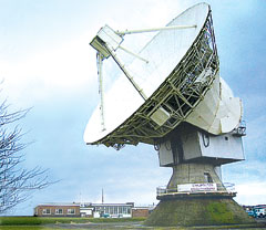
The antenna dish at Chilbolton Observatory.
The test campaign using the large antenna at Chilbolton Observatory to analyze the navigation signals transmitted by GIOVE-A, the first Galileo satellite, has been successfully completed, the European Space Agency (ESA) announced in mid-August.
Analysis of the satellite’s signals since January 2006, to verify their conformance with the Galileo system specification, has involved the Navigation Laboratory at ESA’s European Space Research and Technology Centre (ESTEC) in the Netherlands, the ESA ground station at Redu, Belgium, and the Rutherford Appleton Laboratory (RAL) Chilbolton Observatory in the United Kingdom.
Following signal analysis, operators have made some adjustments, re-programming the spacecraft’s navigation signal generation unit to compensate for changes to the signals introduced by the amplifier that boosts them for transmission to Earth and by a filter that protects adjacent frequency bands from interference.
To achieve the correct solution, the calibrated Chilbolton station was used to receive the signals from GIOVE-A. ESA’s Navigation Laboratory processed the resulting data. The signal generator manufacturer, TAS (France), calculated the new settings for the unit. Finally, the satellite manufacturer, Surrey Space Technology Limited (SSTL), uploaded the new values to the payload using their ground station at Guildford, in the United Kingdom.
According to ESA, “GIOVE-A is now transmitting optimized signals. Research and testing continues, and manufacturers are using the signals as they develop the receivers that users will need when Galileo enters operational service.”
Global Search and Rescue. Once operational sometime after 2012, Galileo will improve the detection of emergency beacons, according to program representatives whoattended the annual Joint Committee Meeting of COSPAS-SARSAT, the international program for satellite-aided search and rescue. Galileo satellites will carry transponders to relay distress signals to search and rescue organizations. Galileo partners have committed to developing a search and rescue component as an integral part of Medium Earth Orbit Search And Rescue (MEOSAR), the future worldwide search and rescue satellite system.
COSPAS-SARSAT already has systems operating in low-Earth orbit and geostationary orbit. The low-Earth orbit satellites can determine the location of emergency beacons using the Doppler effect as they pass overhead. However, there is a delay in relaying the distress signal because the satellites can only “see” a part of the Earth’s surface at any given time and a beacon is only detected when the satellite passes nearly overhead. Also, the satellites must store the location of the emergency and transmit it to a ground station once one comes into range, creating further delay.
Search and rescue transponders on geostationary satellites can constantly view a large, fixed area of the Earth, eliminating the time delay in detecting distress signals. However, they cannot automatically determine the location of the distress beacon as the low-Earth orbit system does, but must rely on the beacon to use a navigation system to find its position and include it in the distress call.
Emergency beacons require a direct line-of-sight to the geostationary satellites. There are some situations where this is impossible, such as near the Earth’s poles, where the satellites are too low in the sky, or when an accident occurs where surrounding terrain obscures the satellite.
Future Improvements. To improve performance of the overall COSPAS-SARSAT system, plans are now being made to fly search and rescue payloads on future navigation satellites. The various navigation satellite constellations will each have about 20 to 30 satellites in medium-Earth orbit, providing global coverage, including at the Earth’s poles, and with multiple viewing angles to the satellites, eliminating terrain blocking.
The Galileo search and rescue component will provide two services. The Forward Link Alert Service, backward-compatible with current COSPAS-SARSAT components and interoperable with all other planned MEOSAR elements, detects activated distress beacons and notifies the appropriate rescue body. A new Return Link Service will send a return message to the emergency beacon, notifying the emergency victims that their distress signal has been received and help is on its way.
The Galileo In-Orbit Validation Programme, which will have four satellites fitted with search and rescue transponders, will demonstrate the Galileo MEOSAR services — although its flight timetable has yet to be finalized or announced.
DOT Weighs NDGPS Future, Asks Public Input
The U.S. Department of Transportation’s (DOT) Research and Innovative Technology Administration (RITA) is preparing an assessment on the inland component of the Nationwide Differential Global Positioning System (NDGPS) that will determine its future.
As part of that assessment, it is seeking public input from users of the system.
The current expansion of the NDGPS has been placed on hold pending congressional review of the system’s funding; RITA’s assessment is part of that review. Differential GPS uses the fixed location of a reference station on the ground to improve the positioning resolution provided by civilian GPS satellite signals down to 1–3 meters. NDGPS facilities also monitor GPS satellites for anomalous behavior and issue integrity warnings when necessary.
The NDGPS program is operated jointly with the DOT’s Federal Highway Administration, Federal Railroad Administration, and Office of the Secretary of Transportation; the Department of Homeland Security’s U.S. Coast Guard; the Departmentof Commerce’s National Geodetic Survey and Forecast Systems Laboratory; and the Department of Defense’s Air Force and Army Corps of Engineers. Begun in 1997, to date there are 37 operational NDGPS sites. Two additional sites are ready for construction and could be operational in a matter of months, according to the Coast Guard.
As part of the assessment, RITA published a notice in the Federal Register addressing the current user requirements for the inland or terrestrial component of the NDGPS. This assessment is in preparation for making a recommendation to the National Space-Based Positioning, Navigation and Timing (PNT) Executive Committee, which oversees the entire GPS, on the need to continue to operate inland NDGPS and to make a decision on its future funding.
If no transportation requirements or other federal user requirements are identified as a result of the needs assessment, and if there are no other federal or other funding sources willing to sponsor or partner in sponsoring NDGPS, the DOT will develop a decommissioning plan for NDGPS, according to RITA.
The deadline for public comment is October 1, 2007. Comments may be submitted via the Internet at the Department of Transportation Web site. Instructions for other methods of submitting comments, including via postal service and fax, can also be found there in the docket management portion of the site.
The Robots of DARPA
The U.S. Defense Advanced Research Projects Agency (DARPA) has named 36 teams as semifinalists for its Urban Challenge to take place later this year.
The DARPA Urban Challenge will feature autonomous ground vehicles executing simulated military supply missions in a mock urban area. It will take place November 3at an urban military training facility located on the former George Air Force Base in Victorville, California.
The 36 semifinalists will compete in the Urban Challenge National Qualification Event (NQE), October 26–31. The top 20 teams from the NQE will move on to the Urban Challenge final event on November 3, and compete for cash prizes worth $2 million for first, $1 million for second, and $500,000 for third place.
At the NQE and the final event, the robots must operate entirely autonomously, without human intervention, and obey California traffic laws while performing maneuvers such as merging into moving traffic, navigating traffic circles, and avoiding moving obstacles. DARPA conducted competitive site visits across the United States to select the semi-finalists.
“The depth and quality of this year’s field of competitors is a testimony to how far the technology has advanced since the first Grand Challenge in 2004,” said DARPAdirector Tony Tether.
Stanford University’s winning robot vehicle from the last DARPA Challenge in 2005, which ran across the Mojave Desert, consisted of a stock Volkswagen Touareg R5 thatincorporatesd measurements from GPS, a 6DOF inertial measurement unit, and wheel speed for pose estimation.
Spirent Federal Systems Inc. said today that Rockwell Collins has selected Spirent Federal to supply multiple GPS simulators to support the Modernized User Equipment (MUE) Receiver Card Development contract it has with the GPS Wing.
The GPS modernization effort is a system-wide program that includes upgrades to the space, control and user segments.
The award includes Spirent Federal’s GSS7700 Series GPS Simulator, fully approved classified package, interface/jamming and Advanced Encryption Standard (AES) M-Code and Simulator Data Sets (SDS) M-Code capability. Spirent Federal has already received the Global Positioning Systems Wing security approval for its SDS Upgrade Package for the GSS7700 GPS Simulator last month; it is the first company to obtain security approval for a simulator that meets all the requirements for MUE, including the new SDS M-Code capabilities, the company says.
Spirent manufactures an extensive range of GPS test equipment, from simple production test units for the commercial market to the GSS7700 series for more technically demanding applications. Configurations include GPS L1 only, dual-frequency L1/L2 (including L2C), L5, a fully approved classified package, Satellite Based Augmentation Systems (SBAS), interface/jamming simulation, inertial interfaces, Hardware in the Loop (HIL) test capability, high dynamic capability, and M-Code. Spirent Federal also offers Russian GLONASS simulation and European Galileo simulation.
I recently attended the 23rd National Space Symposium in Colorado Springs, Colorado. As I walked around the exhibit halls one morning, I couldn’t help but think that of all the 140 exhibitors, there were only a handful, less than five actually, whose livelihood was not inextricably linked to GPS.
To think that all these billion-dollar companies, and the start-ups as well, depended to such a great degree on a ubiquitous global utility that only became available on a global basis because of a seemingly insignificant, but in the end. deadly navigation error. Add to this the naked aggression and paranoia of the former Soviet Union and the benevolence and caring of a legendary U.S. President, and you have the beginnings of a tale that has changed our world forever, and whose final chapter may never be written.
You can go directly to each topic by clicking on the respective link above, or read the whole column by simply starting with the first one.
The past
It was almost 24 years ago that a commercial (passenger) Korean airliner inadvertently strayed into Soviet airspace because of a navigation error that probably occurred while the aircraft was still parked on the tarmac in Alaska. Investigators now believe that the flight crew accidentally entered the wrong parking spot coordinates into their inertial navigation system) and therefore were off-course from the moment they departed. This original, seemingly insignificant error of only a few feet was magnified on their long over-water flight with no other enroute navigational aids to ameliorate their error. At that point in time the best INS was only good to about 1 nautical mile per hour for cross-track navigation accuracy and without updates could easily be ten nautical miles off after ten hours of flight time. The original position error resulted in an initial erroneous heading of 245 degrees and a prevailing westerly wind all conspired to place them over Soviet Territory without their knowledge.
But wait, you say, the GPS constellation was in orbit and transmitting in 1983. Surely this would have automatically corrected the INS error; indeed it may have helped, if GPS had been available to commercial airliners at the time. But on this infamous date in 1983 GPS was restricted to government and military use. Originally designated the NAVSTAR (Navigation System with Timing And Ranging) Global Positioning System, GPS was developed by the U.S. Department of Defense, with the Air Force as the lead, to provide all-weather round-the-clock navigation capabilities for military ground, sea, and air forces.
Only a handful of civilians were receiving the signals from space and then only for use in research and development programs. The general public knew almost nothing about the system, and certainly no commercial airlines were using it as an approved navigation aid. At the time of this incident, only eight GPS satellites were in orbit around the Earth. There should have been nine satellites, but the one and only GPS launch failure occurred in 1981. A full constellation is officially considered to be 24 satellites (four satellites in six planes). The United States current GPS constellation consists of 31 operating satellites of various ages and capabilities.
Dr. Bradford Parkinson (Col, USAF Ret and Professor Emeritus of Physics at Stanford University) and I have discussed many times the fact that the United States and thus the world came very close to not having a GPS of any description. Among others, Brad was a visionary and was also the first USAF GPS JPO Director and as such was responsible for getting the first GPS satellites in orbit. In truth Brad had the responsibility for putting the whole GPS plan and strategic vision together and selling it to the government, and it almost didn’t happen. But that is a story for another time; suffice it to say we all owe Dr. Bradford Parkinson a great deal of gratitude for his dedication, professionalism, and, I suspect, persistence.
So on September 1, 1983, Korean Air Flight 007, a Boeing 747, was on its own, navigating without GPS, and depending upon a perfectly good INS that had been programmed incorrectly and consequently informed the flight crew they were on-course and definitely not in Soviet airspace. Unfortunately, they were in Soviet airspace and had been for some time. Relations between the Soviet Union and Korea were not all that friendly in 1983. A few years before another Korean airliner had been shot down and crash-landed in the Soviet Union. Even though the Soviet interceptor pilots clearly saw the intended target carried the markings of a civilian airliner, (it’s hard for any pilot to mis-identify a 747), they followed orders (how many times have you heard that cliché) and blew the airliner out of the sky, just west of Sakhalin Island. KAL 007 carried 269 passengers and crew, including U.S. Congressman Lawrence McDonald. There were no survivors. An initial minor navigation error of a few feet, and 269 innocent civilians lost their lives, and as a consequence unknowingly ushered in the GPS Age for the rest of the world.
Shortly after this tragic event, President Ronald Reagan went on national and international television to decry this barbaric act by the Soviet Union and to offer the world a solution: an absolutely free and no-strings-attached solution that should prevent such a tragedy from ever occurring again, at least from a navigation error. That solution was GPS, and it was a far cry from the GPS we know today — but that again is also a story for another time. It is enough to say that in this event and in many others throughout time, history has conspired to bring out the worst and the best of mankind, and consequently the world will never be the same.
The Future
So much for the history lesson. Lest I digress, there I was in Colorado Springs and about to see a navigation solution come to fruition that may have world-changing effects of its own. I first heard about Dr. James Spilkers’ new navigation idea about three years ago when we were sitting at breakfast together just before a GPS Independent Review Team meeting at IDA (Institute for Defense Analyses) in Arlington, Virginia.
Dr. Jim Spilker (the father of the GPS signal as we know it today and the founder of Stanford Telecom), Dr. Brad Parkinson (former CEO of Trimble and former Chairman of the Board of Aerospace Corporation), Dr. Edwin Stear (former Senior VP and Chief Scientist at Boeing), Dr. Alison Brown (CEO of NAVSYS), John Darrah (former Chief Scientist of Air Force Space Command) and I were discussing Dr. Spilkers’ newest idea for navigation in areas where GPS provides a compromised solution, such as urban canyon situations, indoors etc.
Jim’s idea was to use existing, unmodified television signals as an enhancement to GPS navigation. His thinking at the time was that since the location of television transmission towers is surveyed down to the centimeter, and the signal strength is strong, especially when compared to a GPS signal, then he should be able to determine lines of position, especially if he knew the time of transmission, and then use those LOPs to determine a position and/or to enhance GPS. At the time I remember that while we were all intrigued, we also came up with about twenty reasons why this would be difficult to accomplish, and besides — we had GPS, what more could we want? Even the brilliant among us are at times just a bit naive.
Fast-forward three years and Dr. Spilker, having overcome our paltry suggested technical and bureaucratic impediments, and more hurdles than I care to think about, is announcing the first navigation augmentation/enhancement product from his new company, Rosum: a chip-sized device that can be added to an existing GPS receiver, and uses existing unmodified television signals to determine a position.
But from where do television signals originate today? Certainly from terrestrial sources, and then many are transmitted through cable systems, and at first glance that seems unhelpful, unless you consider where the majority of cable systems get their feeds (downlinks). From geosynchronous satellites of course, just like those of us that forgo the middle man, somewhat, and get our signals direct to the dish on the side or roof of our home or office. Over-the-air television transmitters are located on large earthbound transmission towers that typically put out a lot of wattage and hence signal strength over a 50- to 100-mile radius. Sounds a lot like a super-sized pseudolite to me. Now Jim’s idea starts to sound a little more plausible, doesn’t it?
It is really intriguing how Jim and his cohorts managed to make this happen, and I will write more about it in the future. Hopefully, when I am in LA in a couple weeks time, I can get Jim to relate a little more about how it all came about and the hurdles that had to be overcome plus of course more about the capabilities of the system and Rosums’ future plans and products. Right now you can read more about it in a separate news item in this newsletter. You may also notice that Jim enlisted the help of those around the breakfast table that morning, and they are now either partners, supporters, or cheerleaders in this new navigation venture.
Which of course brings us to our newest augmentation for the PHGPST (Perfect Handheld GPS Transceiver). You guessed it, unmodified existing television signals using the new Rosum chip to allow navigation in what are typically GPS challenged areas of reception and/or during times of jamming or interference.
Many of you have written wanting to know just what all the components of the PHGPST are and indeed they are getting too numerous to mention in every column so we are in the process of establishing a separate place on the web page where these innovations, augmentations and additions will be listed and updated every month.
The Further-Out Future
In my list of notables at breakfast three years past, you will notice that I mentioned Dr. Alison Brown, the founder and CEO of NAYSYS, a twenty-year plus, growing boutique GPS think-tank and production facility located in the foothills of the Rocky Mountains in Monument, Colorado. Alison and I have been friends for more than 17 years and have served on many studies and boards in the past, but lately have been slightly out of touch until I caught up with her at the Joint Navigation Conference in Orlando, Florida last month. Over dinner we discussed her support of Rosum and other GPS matters, but the one that intrigued me most and currently makes the biggest difference to our war fighters and allies is Talon NAMATH.
This critical GPS enhancement allows our warfighters to better use the Air Force’s smaller and newest precision weapon, the GBU-39 small-diameter bomb. Talon NAMATH significantly boosts the bomb’s accuracy and reduces collateral damage to non-combatants. But again this program almost did not happen. With all the budget-cutting and bill-paying due to the war in Iraq and Afghanistan, this critical project was cut from the funding line and it was only through Dr. Brown’s persistence, and warfighter support, which included lots of letter writing and physically walking the halls of Congress, to promote an idea she really believed in, that Talon NAMATH managed to get out of the idea stage and into the field.
Other supporters of numerous key innovative Talon programs like Talon NAMATH are the seven Air Force Battle Labs, which are now being shut down because of budget constraints. Six of the seven Battle Labs were established in July 2007 by directive of then-Air Force Chief of Staff General Ronald Fogleman, who wanted the Air Force to capitalize on innovation and have the ability to fast track programs crucial to our war fighters.
Without exaggeration, I know I could write columns for the next ten years about Talon programs that have saved lives and innovations that have changed the face of warfare for our military members, not just in the Air Force, but across the DoD and for our Allies as well. I feel strongly that this is a monumental mistake and the Air Force will soon regret this decision. Shutting down an innovative and proven successful fast-tracking acquisition program while this country is at war is a disservice to our war fighters and one I predict the Air Force will re-energize either as reconstituted Battle Labs; or if that proves to be too embarrassing then under a different name, but with the same stated purpose.
I am running out of time and room, but I do want to thank all those who continue to write and I want to remind you that I always answer my mail.
A Boeing-led team is working on a so-called Robust Surface Navigation (RSN) concept for the U.S. Defense Advanced Research Projects Agency (DARPA). The objective of the RSN program is to develop navigation technology that can be exploited in the event GPS signals are jammed, blocked or otherwise unavailable.
In theory an RSN system would utilize various “signals of opportunity” — signals emanating from satellites, but also those emanating from cell phone towers and television transmission towers, for example — to provide precise location and navigation information to users on the ground.
“The challenge is to develop an integrated system that can use all available signals — not just GPS — to provide accurate navigation information through one small receiver, thereby eliminating the need for an expensive, fixed infrastructure,” Bart Ferrell, Boeing Phantom Works program manager for Precision Navigation Programs, said in a statement.
The Boeing-led RSN team is beginning its 15-month Phase 1 concept development contract. The team includes Rosum of Mountain View, Calif.; Shared Spectrum, of Vienna, Va.; and veteran GPS navigation company Navsys.
Rosum has used broadcast television signals to locate mobile assets and has combined television and GPS signals in location-based applications. Shared Spectrum supplies cognitive radio technologies for government and commercial customers with challenging radio communications and networking needs. Its expertise includes defense communications in extremely challenging RF conditions and commercial communications involving novel approaches to sharing and managing spectrum access.
The Boeing Co. announced concepts for combining the GPS network with the Iridium low-earth orbit telecommunication network to improve accuracy, and signal acquisition in urban environments. Boeing executives delivered the briefing at the National Space Symposium for Pentagon and industry officials. There is no firm plan to turn it into a fielded system, however.
“In any event, this would not obviate the need for GPS upgrades in any way,” said retired Maj. Gen. Craig Cooning, vice president and deputy general manager of space and intelligence systems at Boeing. “What it does represent is an elegant solution for augmentation of GPS.”
According to the company, GPS signals could be acquired more quickly through amplification and rebroadcasting in a low-earth-orbit system.
Iridium is a constellation of LEO communication satellites originally developed by Motorola Inc. in the late 1990s. When the system proved uneconomical, it was almost de-orbited early in the decade, until the Defense Department and private investors put in new money to keep the systems in orbit. The Iridium constellation would have to be replenished in order to support the IGPS concept, according to Boeing, but an upgrade of the system would be necessary in any event by 2014.
The Defense Advanced Research Projects Agency (DARPA) will award $2 million, $1 million, and $500,000 awards to the top three robotic finishers who complete its new Urban Challenge course in November 2007.
Under Secretary of Defense for Acquisition, Technology and Logistics Kenneth J. Krieg approved the cash prizes, evidencing the Department’s interest in making one-third of all combat vehicles — principally supply vehicles — driver-less by 2015.
DARPA has staged two desert Grand Challenges, in 2004 and 2005 in the Mojave, with significant difficulties posed by geography and terrain. The 2007 Urban Challenge will feature fully autonomous ground vehicles conducting simulated military supply missions in a mock urban area. The race will take place on November 3, 2007, at a location to be announced later, in the western United States.
Robotic vehicles will attempt to complete a 60-mile course through traffic in less than six hours, operating under their own computer-based control. Vehicles must obey traffic laws while merging into moving traffic, navigating traffic circles, negotiating busy intersections, and avoiding obstacles.
Learning Curve. Participants in past Grand Challenges have truly risen to the occasion, learning and innovating as they go. The number of sensors and software applications integrated into most of the experimental vehicles increased dramatically between the first and second races. Inertial sensors proliferated, with cost, size, and power consumption going down, while performance went up. Inertial systems, along with various camera/vision apparati, function as the workhorses covering the ground in most of the vehicles. GPS generally teams with a central processing unit (CPU) to act as the brain guiding the process.
William “Red” Whittaker of Carnegie Mellon University’s Robotics Institute and Louis Nastro of Applanix Corporation co-authored a detailed technical article in September 2006 GPS World on their experience with the students of Carnegie Mellon’s Red Team Racing effort, designing and outfitting two vehicles that competed and placed in the 2005 race.
To qualify for the race or simply watch, see the Grand Challenge website for additional information and rules for the Urban Challenge.
This week, TerraGo Technologies announced that it has entered into a strategic agreement with In-Q-Tel – an independent venture capital fund tasked with identifying new technologies for the Central Intelligence Agency (CIA) and the larger intelligence community (IC) – to spark the development of new mapping solutions needed by such IC leaders as the National Geospatial-Intelligence Agency (NGA).
For several years now, many government agencies (including the US Army Corps of Engineers, USACE), have relied on TerraGo’s innovative GeoPDF proprietary data-sharing format to exchange geospatial data between users of varying skills levels – from engineers on the scene of natural disasters like Hurricane Katrina to soldiers in the field who can use Adobe Reader to manipulate maps. The agreement between TerraGo and In-Q-Tel is expected to advance the development of GeoPDF and related technologies to meet the operational demands of these organizations, as they continue tackling such challenges as the Global War on Terror and emergency response for major natural and manmade disasters.
Since its first MAP2PDF for Adobe Acrobat product was introduced seven years ago, TerraGo has evolved the technology that allows for the creation and sharing of digital map display files in a user-friendly format. Today’s GeoPDF format allows users to convert raster and proprietary CAD and GIS mapping and database information to text-searchable, georeferenced PDF files. It also allows for the creation of both georegistered and GIS database-embedded PDF files – hence the term GeoPDF.
With GeoPDF, users can send complex, georegistered maps as PDF files with layers and embedded feature attributes. A GeoPDF can be distributed and used in connected or disconnected modes with the free Adobe Reader and GeoPDF Toolbar software. Users can view finished digital maps, turn layers on and off, query attributes, display coordinates, measure distances, and track locations via GPS . . . all without the need for specialized geospatial knowledge or training.
For an example of how USACE is using the GeoPDF file format, we can look to the corps’ Topographic Engineering Center (TEC). Currently, TEC is creating unclassified/for official use only digital map displays for regions of the world where the Global War on Terror is being fought. TEC has created DVDs for five countries in support of the war, and it has distributed these DVDs to the military. The project has included taking all of the NGA standard map sheets of Korea, having them scanned and converted to GeoPDFs, and packaging them with an index sheet. By the end of the year, TEC anticipates having created 30-plus country DVDs that consist of all NGA standard products in raster GeoPDF format. The center is also awaiting NGA’s delivery of vector-based GeoPDFs for inclusion in the country DVDs.
It’s abundantly evident that TEC and NGA have bought into the GeoPDF concept in a big way. Whether TerraGo will be the only GeoPDF name in town remains to be seen, but I think it’s inevitable that the technology itself is here to stay, in both the private and the public sector. In the intelligence community, GeoPDF is clearly a smart way to share geospatial information quickly and easily, especially when the nation’s welfare – and American lives – might be on the line.
Editor’s Note: Eric Gakstatter, a GPS/GIS consultant with Discovery Management Group LLC, and Ray Caputo, a geographer with the US Army Corps of Engineers Topographic Engineering Center, contributed to this editorial.
 Robotic vehicles will attempt to complete a 60-mile course through traffic in less than six hours, operating under their own computer-based control. Vehicles must obey traffic laws while merging into moving traffic, navigating traffic circles, negotiating busy intersections, and avoiding obstacles.