Category: Defense

  • North Korea Jamming Incident; LightSquared Issue

    My mailbox is currently overflowing with comments and questions concerning rampant rumors that in the March 2011 time frame a U.S. military reconnaissance aircraft was forced to land during an annual major east Asian military exercise, known as Key Resolve, due to GPS jamming. The jamming reportedly took place along the northern portion of the 684-mile long Korean peninsula, with the jamming supposedly originating with the North Koreans. The jamming scenario should come as no surprise, but it is the emergency or forced landing due to loss of a GPS signal among other supposed “facts” with which I take issue.

    The Rest of the Story

    As a former USAF (United States Air Force) aviator, who spent literally thousands of hours in the cockpits and mission compartments of various and highly sophisticated reconnaissance aircraft, allow me to set the record straight on several important issues. First the reports that the plane was forced down or made an emergency landing due to loss of GPS are certainly inaccurate, an exaggeration, and a devious way to generate headlines. The journalist who initially reported the incident was simply seeking media attention and was unfortunately successful. The reconnaissance aircraft was not forced down by jamming or enemy interference but rather the aircraft commander took the most prudent action, both from a military and political vantage point, and it may well have saved lives.

    Sordid Aviation and Military History

    Lest we forget, historically civilian airliners have been harassed, intercepted and even shot down in this area of the world. Consider North Korea’s extreme and high-profile actions of late concerning the U.S and South Korean military as well as the civilian populace of South Korea are solely for the purpose of provoking a military response. Both the U.S. and South Korean military have shown remarkable restraint. This latest jamming incident is merely another in a long series of provocations by North Korea. Remember the North Koreans reportedly sank a South Korean military vessel recently, with all lives lost, because it was supposedly in North Korean waters. Authorities do not know, or have not said, for certain if the South Korean vessel experienced GPS jamming, but GPS readouts and coordinates have now become the defacto standard for proving or disproving the legitimacy of reported border incursions, whether by land, sea, or air.

    To reiterate, the U.S. reconnaissance pilot took the prudent action once the GPS signal was reportedly jammed even though I can assure you the pilot (and crew if there were any) had numerous other means of navigation at their disposal. None of our reconnaissance aircraft depend solely on GPS for PNT information.

    Unlike so many of the critical, uninformed responses I have read concerning this incident, I applaud the reconnaissance pilot for making the right decision. And since this was a reconnaissance aircraft, it is very possible the military gained all the necessary data before deciding to terminate the mission. Suffice it to say our SIGINT (SIGnals INTelligence) tools are extremely sophisticated.

    Are We Too Dependent on GPS?

    This incident reminds me that the 19th USAF Chief of Staff, General Norton A. Schwartz, provoked quite a furor just 20 months ago when he spoke of a troubling operational dependency on GPS that must be tempered by other technologies and capabilites lest we become too dependent on one technology that could be denied our warfighters at critical times. It was reported at the time, by yours truly in GPS World and others, that General Schwartz’s call for alternative or augmenting technologies was “driven by serious threats to GPS… Officials familiar with the issue would not discuss current threats; however, they confirmed the GPS has been jammed or interfered with recently.”

    Course of Action

    The correct course of action is not to limit GPS — just the opposite. Refine GPS; increase the overall signal strength and accuracy for all users by integrating GPS with other embedded PNT (Position, Navigation and Timing) and communications systems through the use of intelligent software-defined receivers capable of utilizing all PNT signals available.

    The dynamic Perfect Handheld or embedded GPS Transceiver (PHGPST) that I originally wrote about in March 2007 has evolved. The PHGPST must now be capable of receiving PNT signals from GPS, GLONASS, Galileo, Compass, among others. It must be capable of receiving all the wide area and local area augmentation systems available globally, such as DGPS (Differential GPS), WAAS (Wide Area Augmentation System), and EGNOS (European Geostationary Navigation Overlay Service), just to name a few. Such a system would also utilize a chip-scale atomic clock (CSAC) and ingenious commercial systems such as Skyhook Wireless, which uses Wi-Fi and GPS carrier signals for immediate (under four seconds) PNT results, even indoors.

    Of course, to provide any future PNT capabilities GPS and all other satellite-borne PNT systems must exist within the protected satellite navigation spectrum currently threatened by LightSquared and an apparently clueless FCC (Federal Communications Commission).

    eLORAN

    The current LightSquared debacle and the North Korean jamming incident certainly underscore the reasons for General Schwartz’s concerns. The fact that the U.S. military has recently decommissioned one of the primary and historically viable backups and augmentations for GPS, that was essentially too powerful to be easily jammed — and I am speaking of course of eLORAN — is another matter for another column. In my opinion, and it is an opinion shared by many in the know, decommissioning eLORAN was a major operational blunder induced by minor budget concerns that both the current administration and the Coast Guard need to remedy. I would very much appreciate your comments, pro and con, on the eLORAN debate. This is far from a dead issue. Drop me a line at [email protected]. I digress.

    Historical Viewpoint: Lessons Learned

    The entire incident with the North Korean’s supposedly jamming GPS and General Schwartz’s comments regarding our dependency on GPS brings to light navigation concerns, actions, and lessons we should have learned from another well-known general officer who served as the fifth chief of staff of the USAF and as the commander of Strategic Air Command (SAC). I am speaking of the famous General Curtis “Bombs Away” LeMay who had a well-known aberration for navigation devices that were not passive in nature or integral to the aircraft being navigated. And even though he was primarily a command pilot, General LeMay understood navigation; in 1940 he served as the navigator on the prototype Boeing XB-15 heavy bomber that when it first flew, in 1938, was the most massive and most voluminous aircraft ever built in the United States. Late
    r in his career as USAF CSAF (Chief of Staff) General LeMay strongly advocated the introduction of satellite technology for navigation and pushed for the development of the latest electronic warfare techniques. However, for General “Iron Pants” (the XB-15 could fly unrefueled for over 20 hours) LeMay new technology was never allowed to overshadow or jeopardize the primary mission.

    General LeMay was a big believer in the basics, especially celestial navigation, and I can testify from personal experience that just a few years past, long after the advent of GPS and LORAN (LOng RAnge Navigation), SAC navigators and crews routinely flew vast distances across oceans and continents with nothing but a sextant and a very busy and nervous navigator. General LeMay was also concerned about SIGINT and required SAC aircraft to routinely practice radio and signals silence, no signal emissions. Entire missions were frequently flown from takeoff to landing without a single radio call or signal being transmitted. There were totally radio silent air refuelings by SAC tankers and bombers. Consider that celestial, inertial, eLORAN, and GPS fall into the silent and SIGINT free category. The inveterate cigar chomping and garrulous General LeMay would undoubtedly have approved and championed these new technologies. But he would never have allowed the loss of one capability to compromise the overall mission, and thankfully that same attitude is still prevalent in our Air Force today. Hence the timely comments by General Schwartz.

    Today SAC’s assets (SAC was disestablished as a USAF Major Command — MAJCOM — in June 1992 after the end of the Cold War) are divided among Air Combat Command (ACC), Air Mobility Command (AMC), and Air Force Global Strike Command (AFGSC). To my knowledge none of these MAJCOMs today require crews to carry sextants onboard their aircraft, and indeed many of the newer aircraft do not have sextant ports. Apparently manual aviation celestial navigation skills are no longer taught at the joint military navigation courses except to Navy and Coast Guard shipboard navigators/personnel. Perhaps a back-to-basics approach is needed in training as well as in operations.

    LightSquared Debacle

    While we should not be surprised that GPS jamming takes place, we should be surprised and indignant that the current FCC commissioner has initially authorized legal GPS jamming by LightSquared. I originally penned three articles about the FCC and the ridiculous chain of events that led to the LightSquared debacle, and then circumstances precluded me writing any further articles on the topic. What I can say now is the LightSquared terrestrial transmitters and receivers, if approved by the FCC, amount to FCC-sanctioned jamming that will cause mayhem among GPS users worldwide. This is no longer an issue confined to the CONUS (Continental United States). There are billions of dollars in economic and containment costs at stake as well as lost income and revenue, not to mention the potential loss of life, detailed in a recent FAA report. Approval of the LightSquared terrestrial plan would be a global catastrophe and I am incredulous that the administration and the FCC are still unsure of what action to take.

    Way Ahead

    It is really rather simple: LightSquared originally signed on to provide broadband communication capabilities via satellite to everyone in the U.S. They propose broadcasting in the spectrum allocated to satellite transmissions, and as long as they fulfill that mission at the nominal satellite power levels from orbit there is not an issue. In this originally approved LightSquared scenario, all users would have the capability to receive broadband signals everywhere they can now receive a GPS signal. As we all know, with ever more sensitive receivers you can now routinely receive GPS signals almost everywhere, even indoors. The proposed broadband satellite coverage area provides a huge customer base for LightSquared but apparently it is not enough. It becomes a matter of market dominance versus market share. The FCC needs to wake up and take immediate actions to curtail plans for all high-powered terrestrial transmissions in the protected satellite spectrum or face the disastrous consequences. The North Korean jamming headlines are bad enough; none of us want to read a headline that says “FCC GPS Actions Cause Huge Loss of Life as Airliners Collide.” This is far from over; write your Congressman.

    Until next time, happy navigating.

  • Microtechnology Comes of Age

    By Andrei M. Shkel, Defense Advanced Research Projects Agency (DARPA)

    The aggregated DARPA Microtechnology for Positioning, Navigation, and Timing (micro-PNT) program is pursuing a new wave of innovation focused on bringing to life revolutionary ideas and fabrication technologies on micro/nano/pico/femto/atto scales, packaging, ultra-low-power electronics, innovative algorithms, never-before-explored architectures, and exploitation of new integration paradigms.

    After about two decades of harmonic investment in developments, potential users of so-called small technology for positioning, navigation, and timing (PNT) applications increasingly ask, “Are we there yet?” Clearly, some significant advances have been made, and we see a footprint of the technology in an ever-growing consumer electronics market full of interactive products enabled by inertial and timing microtechnologies. These products include accelerometers for gaming applications, gyros for auto safety, resonators for clocks, and more.

    The question remains, however: Is the technology really on the level of what we consider to be precision navigation and timing, that is, is it capable of achieving an accuracy level of at least 10 meters in position and 1 nanosecond in time throughout the entire duration of missions that may range from minutes to hours to days? In reality, small technology remains several orders of magnitude short with respect to long-term stability, dynamic range, and accuracy compared to conventional technology, which is already known to perform adequately for many military applications.

    Why does making inertial instruments and clocks small necessarily lead to degradation in performance?

    We don’t yet have a complete answer to this question, and we are still working hard to disprove the contention that high-performance inertial micro-instrument is a contradiction in terms. We can make things small, but we cannot yet make them sufficiently precise and uniform; the accuracy of lithography-based manufacturing is on the order of 10–2–10–3 (the ratio of the average defect to the smallest feature size), while the accuracy of conventional manufacturing utilizing precision machining is two to three orders of magnitude higher, on the order of 10–5. We know we can deposit materials layer-by-layer with high precision, but we cannot make micro-devices truly 3D, as is readily achievable using conventional machining. We consistently have an excellent case for low-cost and bulk fabrication, but we cannot seriously challenge so-called boutique processes when it comes to achieving precision, structural complexity, and long-term stability.

    We need new knowledge regarding the dimensional stability of materials. We also need a better understanding of material scaling, surface effects, energy-loss mechanisms, and the consequences of fabrication imperfections on the performance of micro-instruments.

    PNT applications demand both unusual new fabrication technologies and new materials with special properties. To achieve the required phenomenal accuracy for precision navigation and timing, we need a new wave of innovation in design and refinement of many existing transducers. Future breakthroughs in microtechnology for PNT will likely rely on yet-to-be-exploited physics, new materials, highly specialized fabrication technologies and batch assembly techniques, selective wafer-level trimming and polishing, a combination of passive and active calibration techniques strategically implemented right on-chip, and introduction of innovative test technologies.

    Need for Advanced Capabilities

    PNT technology usage has doubled every five years since 1960, mostly due to GPS and the miniaturization of electromechanical components. Future PNT usage is expected to double every two years as a result of telecommunication, automobile navigation, robotics, and other commercial markets inserting micro-electromechanical systems (MEMS) technologies. The modern PNT paradigm is based on the assumption that space-based GPS is accessible most of the time to provide position, velocity, and timing information, enabling every user to operate on the same reference system and timing standard.

    Today’s military systems increasingly rely on GPS, creating a potential vulnerability for U.S. and allied war-fighters should GPS be degraded or denied. When GPS is inaccessible, critical information with respect to position, orientation, and timing can only be gathered through self-contained onboard instruments: a local clock and two triads of inertial sensors (three accelerometers for position and three gyroscopes for orientation). The ideal solution would be a self-sufficient instrument not relying on any external information. Precision microscale clocks and inertial sensors are required to address the paradigm of self-contained PNT.

    Clocks. Position and time have a relationship important to a broad spectrum of military applications, including communication systems that feature efficient spectrum utilization, resistance to jamming, high-speed signal acquisition, and an increase in the period of autonomous operation. Other important applications include surveillance, navigation, missile guidance, secure communications, identification friend-or-foe, and electronic warfare.

    The emerging applications require new compact time-distribution systems technologies capable of achieving signal phase (time) common synchronization of better than 10–9 seconds relative to the Coordinated Universal Time (UTC) standard; intersystem synchronization of less than 10–8 seconds relative to battle group; and less than 10–9 seconds for interoperability, surveillance, and high-speed communications. Solid-state and atomic oscillators are the key components enabling time and frequency distribution for communication, navigation, and command and control systems.

    To support emerging applications, we are interested in clocks with

    • signal phase (time) communication synchronization less (better) than 28 nanoseconds (ns) within 5 minutes (real time), UTC;
    • intersystem synchronization less (better) than 28 ns relative to other system nodes within 5 minutes (real time); and
    • local navigation/communication systems capable of time transfer less (better) than 28 ns, UTC.

    The operational frequency mismatch (δf=f), where f is a nominal frequency and δf is a frequency deviation from the nominal, is a measure of oscillator quality and subsequently the quality of the frequency distribution system. Different applications can tolerate different levels of frequency mismatches. For example, for low-accuracy aircraft/land mobile platforms, the requirement for frequency mismatch is 10–12, while for intermediate land reference sites the requirement is an order of magnitude smaller, 10–13. For large time-division multiple-access (TDMA) systems, the tolerable frequency mismatch is on the order of 10–11.

    Small size, weight, and power (SWaP) are critical metrics for portable time and frequency distribution systems. The target performance characteristic for low-power clocks and oscillators is long-term stability (aging), which need to be less than 10–11/month, with less than 1 W power consumption. It is desirable that the oscillators have small SWaP and preserve the level of long-term stability while surviving an inertial environment with accelerations on the level 10,000 g, where g is the gravity constant.

    For comparison, the one-way satellite transmission from a GPS satellite in common view at two sites allows one to do accurate time transfer to within 10 ns, with a potential to achieve accurate time transfer of the order of 1 ns. Achieving an accuracy of time transfer on the level of 1 ns is loosely defined as precision timing.

    Inertial Navigation Systems. The navigation-grade performance provided by inertial sensors is defined as an INS that accumulates an uncertainty in location not greater than one nautical mile (nmi), or 1.852 km, after one hour of navigation. The error in position is historically defined by the circular error probable (CEP) of 50 percent. The ability to achieve a CEP of 1 nmi in one hour (or 1 nmi/hour) does not translate to a unique performance requirement for a gyroscope and/or an accelerometer. Rather, it presents a trade-off in the overall inertial measurement unit (IMU) error budget. The trades can be generated within a family of gyroscope errors, such as gyro angle random walk (ARW) versus bias drift, or similarly within a family of accelerometer errors. For example, an IMU with gyroscope bias drift of 0.01º/hour combined with an accelerometer bias drift of 25 μg would guarantee a CEP of less than 1 nmi/hour, if no other errors are present. To generate the trade-off space for component performance, one efficient approach is to first generate the parameter space at the linear error covariance level, taking into account the bias drift of components, and subsequently perform  more extensive modeling in a bounded trade-off space by a nonlinear Monte Carlo simulation.

    The ability to navigate and keep precise timing has been an important factor in defining the military and economic power of nations for at least a millennium. For almost a century, the development of high-performance inertial instruments has been an extensive area of research. It is anticipated that the following level of performance will soon be achieved, significantly reducing navigation errors and enhancing military capabilities, within the next 5 to 10 years:

    • < 0.1 nmi/hour CEP for aircraft, vehicle, or spacecraft for attitude, guidance, and control;
    • < 1.0 nmi in 30 hours for ships;
    • < 0.4 nmi/hour CEP for missiles.

    It is critical that future-generation INS systems be capable of operating through shock levels greater than 1,000 g.

    Similar to clocks, the reduction of SWaP and cost (SWaP+C), while not compromising in performance, are the critical metrics for future development of IMUs. The current performance of state-of-the-art MEMS-based IMUs is on the level of tactical grade, with CEP approaching 100 nmi/hour. There is a great potential for achieving performance improvements that will subsequently enable platforms for personal navigation, precision navigation of small unmanned aerial vehicles (UAVs), unmanned underwater vehicles (UUVs), and GPS-free navigators for missiles. It is expected that the performance levels of chip-scale inertial instruments and clocks, shown in Table 1, could be achieved within the next 5 to 10 years, thus significantly enhancing military capabilities. The conservative estimations are projected by the Department of Defense’s Science and Technology List for Positioning Navigation and Timing. The aggressive estimates presume successful completion of the micro-PNT program described here.

    The military has access to a currently specified accuracy of 21 meters (95 percent probability) from the GPS Precise Positioning Service (PPS). Accuracy can be improved after calibration for some of the GPS errors, for example, by utilizing optimal estimation techniques correlating GPS and INS signals. A CEP of less than 10 meters has been routinely achieved, with a potential to achieve accurate positioning on the order of 1 meter CEP.

    Navigation, guidance, and automatic control are not the only military applications that could benefit from improvements in inertial sensors. Azimuth or north-pointing determination systems include celestial devices, magnetic compasses, and inertial sensors. Utilization of gyroscopes to precisely determine orientation has a number of benefits attributed to their immunity to magnetic fields, speed of acquisition, and potentially small SWaP+C. For this purpose, a variety of inertial equipment is being explored, including IMUs, attitude-heading reference systems (AHRS), and gyro-compasses. Providing an azimuth or north-pointing accuracy of less (better) than 0.5 arc minute multiplied by secant latitude has the potential to significantly enhance military capabilities for many targeting applications, especially for anticipated mobile platforms.

    Current Research

    This section provides an overview of the ongoing efforts funded by DARPA (Defense Advanced Research Projects Agency) under the micro-PNT program.

    Clocks. The potential payoff of the precision-clock technology developed by the program will enable ultra-miniaturized and ultra-low power absolute time and frequency references for applications such as nano/pico satellite systems, UUVs, UAVs, wristwatch-size high-security UHF communicators, and jam-resistant GPS receivers.

    There are currently two efforts within the micro-PNT program involving the development of clocks: Chip-Scale Atomic Clock (CSAC) and Integrated Micro Primary Atomic Clock Technology (IMPACT).

    The goal of the CSAC effort is to create ultra-miniaturized, low-power, atomic time and frequency reference units that will achieve, relative to present approaches: more than 200× reduction in size (from 230 cm3 to <1 cm3); more than 300× reduction in power consumption (from 10 W to less than 30 mW); and matching performance (1 × 10–11 accuracy and 1 ns/day stability). This work, funded by DARPA since 2002, has been supporting 11 teams. The program is currently in its final phase and supports two performers, Symmetricom and Teledyne Scientific. Symmetricom has already demonstrated pilot units that are 1 cm3 in volume, consume on the order of 100 mW of power, and perform on the level of better than 30 × 10–11 short-term 1 sec instability (Allan Deviation) and 5 × 10–11/day (1.4 × 10⁻¹⁰/month) long-term frequency drift.

    The IMPACT program seeks to improve the stability and accuracy of microscale atomic clocks by as much as two orders of magnitude. Atomic-clock performance is affected by buffer gases (nitrogen or argon), which are necessarily present in either rubidium- or cesium-based atomic clocks. Buffer gas atoms interact with alkali atoms and effectively shift the resonant frequency of atoms. Emerging atomic-clock technologies based on laser-cooled atoms and trapped ions could overcome the limitations of CSAC.

    The goal of IMPACT is to create miniaturized, low-power, integrated micro primary atomic clock technology that will achieve significant reduction in size relative to conventional clocks, but slightly larger than CSAC (volume less than 5 cm3 in final package, excluding battery); significant reduction in power relative to conventional clocks, but slightly greater than CSAC (50 mW); and two orders of magnitude increase in performance relative to CSAC (frequency accuracy 1 × 10–13, Allan deviation at one-hour integration time, and stability characterized by 5 ns/day time loss). The work, funded by DARPA since 2008, currently involves four teams: Honeywell, Symmetricom, Sandia National Laboratories, and OE Waves.

    The overall approach is based on sampling of atomic transitions at extremely low temperatures, requiring vacuum on the level of 10–9 Torr and the ability to trap atoms in a small volume. The technology has been previously demonstrated on a large scale, but transferring the technology to small scale is far from trivial, requiring major innovations. The effort has already demonstrated magneto-optical trapping in a 16 cm3 atomic cell, and chip-scale clocks implemented using cold atoms performing on the level, quality factor × signal/noise ratio ∼ 2.6 × 10¹⁰, time loss after 1 ms equal to 10–4 ns; after 1 second, 6 × 10⁻³ ns; after 1 hour, less than 10 ns; and after 24 hours, on the order of 100 ns. Frequency retrace was demonstrated at the end of the phase on the level of 10–11.

    Inertial Sensors and Systems. There are currently three efforts within the micro-PNT program involving the development of inertial sensors and systems: Navigation-Grade Integrated Micro Gyroscopes (NGIMG), Micro Inertial Navigation Technology (MINT), and Information Tethered Micro Automated Rotary Stages (IT-MARS).

    The NGIMG effort seeks to develop tiny, low-power, rotation-rate sensors capable of achieving performance commensurate with requirements for GPS-denied navigation of small platforms, including individual soldiers, unmanned (micro) air vehicles, unmanned underwater vehicles, and even tiny (for example, insect-sized) robots. By harnessing the advantages of microscale miniaturization, the NGIMG effort is expected to yield tiny (if not chip-scale) gyroscopes with navigation-grade performance characteristics: overall size less than 1 cm3 (no power source), power consumption less than 5 mW, ARW less than 0.001°/√hour, bias drift less than 0.01°/hour, scale factor stability on the order of 50 parts per million (ppm), full-scale range greater than 500°/sec, and bandwidth on the order of 300 Hz.

    The NGIMG effort has been funded by DARPA since 2005, and work is currently being conducted by three teams: Northrop Grumman, Boeing, and Archangel Systems. The work has demonstrated several experimental prototypes (some, but not all, independently verified by the government) performing on the level of ARW 0.01°/√hour,  and bias drift 0.05°/hour.

    The MINT effort seeks to develop microscale low-power navigation sensors that allow long-term (hours to days) precision navigation in GPS-denied environments. The goal is to create high-precision, navigation-aiding sensors that directly measure intermediate inertial variables, such as velocity and distance, to mitigate the error growth encountered by integrating signals from accelerometers and gyroscopes alone. In addition to aiding sensors such as velocity sensors, the combination of microscale inertial sensors will be integrated to a form-factor of one or two integrated circuits. Such an integrated sensor suite will be incorporated into the sole of a shoe for accurate and precise velocity sensing using zero-velocity events during walking.

    The final goal of MINT is to achieve an overall package and form-factor for a velocity sensor (excluding IMU) of less than 1 cm3, power consumption for the velocity sensor of less than 5 mW, 1-meter position accuracy after 36 hours of walking, and 10 µmeter/second velocity sensing bias per step. The effort has been funded by DARPA since 2008 and involves work by four teams: Carnegie Mellon University, Analog Devices, Northrop Grumman, and Case Western Reserve University/University of Utah. To date, the work has demonstrated positioning error on the order of 4 meters after 30 minutes of walking.

    The goal of the IT-MARS program is to implement and demonstrate a MEMS-fabricated rotary stage providing a rotational degree of freedom to planar MEMS structures and sensors, thus enabling free rotation of micro-structures and micro-sensors relative to the package, with coupled power and signal transfer from the rotating platform to the package. The IT-MARS effort may enable highly accurate calibration of inertial sensors and serve as a micro-platform for carouseling of inertial sensors that further enable on-chip calibration and gyro compassing. The ultimate program goal is to achieve an overall volume of no more than 1 cm3, power consumption for actuation on the order of 10 mW, angle position absolute accuracy to within 1 milli-degree, maximum wobble of 10 micro-radians, a rotation rate of 360°/second, and reliability (run time of rotor) greater than 104 hours.

    This effort, which has been funded by DARPA since 2009, supports three teams: UCLA, UC-Berkeley, and the Boyce Thompson Institute. The work has already demonstrated free rotated platforms, and future efforts will focus on manufacturability and precision control of the stage-rotation and reduction of wobbling.

    New Initiatives

    In January 2010, DARPA launched a coordinated effort focused on the development of microtechnology specifically addressing the challenges associated with miniaturization of high-precision clocks and inertial instruments. The new program, Microtechnology for Positioning, Navigation, and Timing (micro-PNT), aggregated the existing efforts (CSAC, IMPACT, NGIMG, MINT, and IT-MARS) and initiated four complementary new developments:

    • Microscale Rate Integrating Gyroscopes (MRIG),
    • Chip-Scale Timing and Inertial Measurement Unit (TIMU),
    • Primary and Secondary Calibration on Active  Layer (PASCAL),
    • Platform for Acquisition, Logging, and Analysis of Devices for Inertial Navigation & Timing (PALADIN&T).

    The overall goal of the new aggregated micro-PNT program is to focus all of these complementary efforts toward achieving one specific overarching goal: self-contained chip-scale inertial navigation (see opening illustration). The reduction of SWaP+C of IMUs and timing units (TUs) is the technological objective. The developments consider a number of operational scenarios, ranging from dismounted-soldier navigation to navigation, guidance, and control (NGC) of UAVs/UUVs and guided missiles. The new micro-PNT initiatives will increase the dynamic range of inertial sensors, addressed by the new MRIG effort; reduce the long-term drift in clocks and inertial sensors, addressed by the PASCAL work; develop ultra-small chips providing position, orientation, and time information, addressed by the TIMU effort; and provide a universal and flexible platform for the testing and evaluation of components developed within the comprehensive micro-PNT program, addressed by the PALADIN&T effort.

    The primary goal of MRIG is to create a vibratory gyroscope that can be instrumented to measure the angle of rotation directly, thereby extending the dynamic range and eliminating the need for integrating the angular rate information; MRIG will thus eliminate the accumulation of errors due to numerical/electronic integration.

    The final goals are to:

    • extend the dynamic range to 15,000°/second;
    • achieve drift repeatability on the level of 0.1°/hour (angle dependent) and 0.01°/hour (bias-dependent) under variable –55°C to 85°C thermal conditions;
    • achieve ARW of 0.001°/√hour, an operation range of 1,000 g with acceleration sensitivity of 10–5 degrees/hour/g, vi
      bration sensitivity angle random walk of 0.01°/√hour per g/√Hz, and drift rate of 0.01°/hour per g2/√Hz.

    These performance characteristics are thought to be achievable through development of precision 3-D fabrication technologies utilizing high-Q materials; development of wafer-level balancing and trimming techniques that reduce the effects of aniso-inertia (mass misbalance), aniso- compliance (stiffness misbalance), and aniso-damping (damping misbalance); and development of active control and an active calibration architecture.

    These performers have been selected for the initial phase of the MRIG effort: Draper Labs, Honeywell, Northrop Grumman, Systron Donner, UC-Irvine, UC-Davis, UCLA, Cornell, University of Michigan, and Yale University.

    The TIMU effort will address challenges associated with the development of a miniature (10 mm3), low-power (200 mW), high-performance (CEP on the order of 1 nmi/hour), and self-sufficient navigation system on-a-chip. The smallest state-of-the-art IMUs perform on the level of tactical-grade instruments (CEP on the order of 100 nmi/hour) and are about the size of an apple (more than 104 mm3). This effort intends to develop a technological foundation for a navigation-grade TIMU (CEP less than 1 nmi/hour and time accuracy of 1 nanosecond/minute) with a significant reduction in SWaP, potentially miniaturizing the TIMU to the size of an apple seed (10 mm3).

    PASCAL will develop self-calibration technologies intended to eliminate long-term bias drift of inertial sensor and clocks. The grand challenge of this effort is to raise long-term bias stability to the level of 1 ppm.

    This level of stability represents a two-orders-of-magnitude improvement compared to state-of-the-art inertial microsensors, currently at 200 ppm. The work will investigate an approach for fabricating sensors on an active layer that may serve as a calibration layer for micro-PNT systems.

    The PALADIN&T effort will develop a universal platform for test and evaluation of early prototypes developed in the micro-PNT program. The effort will also simplify the uniform evaluation of pilot prototypes within the program and provide an early field demonstration, advancing the technology readiness level.

    Conclusions

    Current state-of-the-art microscale clocks and inertial instruments can provide the required level of precision only for missions having a duration of no more than about one minute. The micro-PNT program at DARPA is developing small SWaP+C inertial sensors for a variety of operational scenarios for missions ranging from minutes to hours. Current projects (CSAC, IMPACT, NGIMG, MINT, IT-MARS) mainly focus on navigation, characterized as missions of prolonged durations in relatively benign environments (a few hours of operation on a platform moving at relatively low speed, less than 100 km/hour).

    The new initiatives (MRIG, TIMU, PASCAL, and PALADIN&T) target the challenges of missile guidance for precision engagement scenarios, short duration missions in highly dynamic environments (10 seconds to 3 minutes of operation at speeds of 1,000 km/hour and higher). Ongoing efforts and new initiatives explore new physical phenomena, high-quality factor materials, specialized fabrication technologies, and innovative approaches to system integration.

    Disclaimer. The views, opinions, and findings in this article are those of the author and should not be interpreted as representing official views or policies, either expressed or implied, of the Defense Advanced Research Projects Agency or the Department of Defense. The document GPS0911 [DISTAR case 17952] is approved for public release, distribution unlimited.


    Andrei M. Shkel received a Ph.D. in mechanical engineering from the University of Wisconsin-Madison and is a program manager in the Microsystems Technology Office at the Defense Advanced Research Project Agency (DARPA), and on-leave professor of mechanical and aerospace engineering at University of California, Irvine, where he is also the director of the UCI Microsystems Laboratory. He holds 15 U.S. and international patents (12 pending) on micromachined angle-measuring gyroscopes, wide-bandwidth rate gyroscopes, light manipulators and tunable optical filters, and hybrid micromachining processes.

  • Product Review: The Trimble Ranger 3

    The Trimble Ranger 3 being tested in its natural environment.


    First of all, thanks to all those who wrote me about the Trimble Ranger 3 and suggested I pen a review.

    Rules of Engagement

    Many of my long time readers will know that I never write a bad review, which is why I found it interesting that an e-mail from a USAF captain fighter pilot in Afghanistan commented that I “seemed to really like” every unit I reviewed. So here again are the ROE (rules of engagement) for my reviews. I will never write a bad review, and believe me I see scores of “bad” (my evaluation) GPS units that I will never review or endorse in GPS World.

    The Trimble Ranger 3 was never of any danger of falling into the “non-review” category. The Ranger 3 impressed me from the very first moment I saw the unit. First of all, it is designated correctly by Trimble, and the military and first responder users who wrote me, as a rugged handheld GPS-enabled computer, and it certainly fulfills all the requirements for that designation.

    If you are looking for a GPS device the size of an Apple iPhone, this is not the device for you. The Trimble Ranger 3 is for the user, and many of you are warfighters and first responders who need a portable and rugged but powerful handheld computer with tightly integrated GPS capabilities that can connect and communicate, wired and wirelessly, with other users and servers. The Ranger 3 can accomplish all that and much more.

    GPS Capabilities

    As soon as I powered up the Ranger 3 for the first time, outdoors for this test, the stopwatch was running to see how long it took to figure out how to enable the unit’s GPS SiRFstar III chip and firmware and obtain an accurate position. This is the new handheld TTFF (time to first fix) scenario that I always go through, in the same geographic location, with any new unit. Some GPS units, even dedicated ones, fail miserably, but not the Ranger 3. Fortunately, the unit’s battery was fully charged when it arrived, and the green power button was obvious. The 4.2 inch TFT (thin film transistor) resistive touch, sunlight readable color screen fired up immediately with a Windows menu soft key, which led me via an iPhone like “flickable” scrolling screen to the GUI (graphical user interface) or icon labeled SatViewer, (version 1.0.4.0) which comes with every Trimble GPS unit I have ever tested or reviewed. I tapped that GUI or icon and hit connect GPS and within 40 seconds had an “unaided GPS position,” or so the voice prompt from the unit informed me. Exactly 28 seconds later I had a “GPS-aided” position, again I was informed by the voice prompt, which can be turned on and off by user input. I found the voice prompts helpful because I did not have to look back at any menus to determine what type of position I was using. The initial position “unaided” was four feet or 1.33 meters from a surveyed reference position at my home, and the “aided” position was under a meter from the surveyed position. As I said, the first unaided position was pronounced 58 seconds after removing the unit from the box for the first time and hitting the power button. The aided sub-meter position was announced at 1 minute and 26 seconds after initial power on. Very impressive, and something very few units can accomplish today. Not even the best MUE or military user equipment available today can equal this feat right out of the box.

    Afterwards I played around with the GPS advanced inputs but found very few settings that needed to be changed. It comes (default mode and with a default button) with SBAS capabilities enabled; in this case the FAA WAAS (Wide Area Augmentation System) was enabled. Had I been conducting this exercise in Europe, EGNOS or the European Geostationary Navigation Overlay would have been automatically enabled. There is also a tab for setting DGPS or differential GPS parameters, on or off or auto, and the unit software is designed for future enhancements. It incorporates an SBAS PRN designation capability, if you want to choose the SBAS PRN number manually, in case one is sending bad data and is NOTAMed (Notice to Airmen) or NANUed (Notice Advisory to NAVSTAR Users) out. Frankly, I just set the SBAS feature to auto and it worked flawlessly.

    GPS Bottom Line

    So the bottom line for the Ranger 3’s GPS capabilities is that the tightly integrated, aided GPS SiRFstar III receiver, compass, accelerometer, and 5 megapixel auto focus camera with auto flash and geotagged image capabilities enable almost endless possibilities for today’s ever-proliferating location-aware software to combine location, bearing, and motion data for use by our warfighters and first responders. Add these capabilities to the substantial communications features of the rugged handheld computer, and you have prodigious potentiality for the Trimble Ranger 3. There is not a single MUE GPS unit today that can touch the Ranger 3 for its tightly integrated GPS and subsequent capabilities and communications.

    I also tested several new windows applications that I will not name now because they require considerable testing before I review or recommend them, but the cogent message is they integrated automatically and worked flawlessly with the Ranger 3.

    Trimble SatView Software

    I will, however, comment on the installed Trimble SatView GPS software on the Ranger 3. It is just so absolutely intuitive that you never really wonder about what to do next, which button to push, or box to check. Just push the button or tap the box or icon you think is the correct one and most of the time you will be correct. And if you aren’t, nothing is undoable. I intentionally push the “wrong” buttons in my tests just to see what happens, and with SatView nothing catastrophic has ever occurred. I have always been able to navigate back to where I needed to be.

    The orbit inspired graphic depiction of the GPS satellites in view (almost always 12) and the satellites being used for your position (from 4 to 10+), to include SBAS satellites, is informative and useful. You merely tap on the PRN (pseudorandom noise code assignment) graphically designated SV (satellite vehicle) and it will open a tiny widow displaying the SVs PRN number, elevation, and azimuth. There is also a very useful graphical illustration of the current P (position), V (vertical), and H (horizontal) DOP for your position, which are also programmable simply by checking a box. Many of you say you don’t know or care about the various GPS DOP, even though Estimation of Dilution of Precision (DOP) plays an important role in determining the overall accuracy of your GPS position. For those of you who do care, the data are readily available on the Ranger 3. All the data, to include programmable mask angles and DOP parameters, can be automatically captured in a log file, saved, and downloaded for future use — a simple and intuitive task. I attached an 8 GB flash drive to the full-size USB port on the Ranger 3, and simply dumped the data log to a file on that device. The Ranger 3 saw the device as an extension of its built-in 8 GBs of flash storage (flash hard drive). You can also save data directly to the onboard flash memory. It is then a simple matter to export the data into an Excel spreadsheet and use however you see fit. Take it from me, not all datalogging programs are this simple and straightforward.

    As the CEO of MobileEpiphany, Glen Kletzky, who produces some of the most intuitive software I have ever had the pleasure of using, once informed me, “Software that is inherently useful with an intuitive interface usually seems simple to the user, but underneath is usually very powerful and sophisticated. My goal as a software provider is to ensure the user never has to deal with the complicated bit
    s.” In this regard, the Trimble SatView software as enabled on the Ranger 3 has met and exceeded the goals of simplicity, usefulness, exportability, and intuitiveness.

    Trimble Ranger 3 Specifications

    Now that we have covered the basic GPS functions, let’s look at the unit itself and all the Ranger 3’s integrated capabilities.

    As I said, the unit is physically imposing, especially if you are looking for an iPhone-type device, which the Ranger 3 is definitely not. But neither can the iPhone accomplish all the tasks of a rugged, handheld portable computer with multiple scanners, readers, and numerous ports.


    Physically the Trimble Ranger 3 is not small. It is 10.5 in × 5.2 in × 1.9 in (26.6 cm x 13.1 cm x 4.8 cm) and weighs in at 2.3 lb (1.04 kg), including battery and stylus. You don’t have to use the stylus, but for some functions it is more accurate than your fingertips. And of course, since this is a Trimble unit, to paraphrase that great entrepreneur Henry Ford, “You can have it in any color you desire as long as it is your basic black…with a yellow face.”

    The Ranger 3 has an elastic (black, of course) hand strap that stores the stylus, and enables you to hang on to the Ranger 3 during all kinds of field maneuvers. The stylus is also tethered to the back of the Ranger 3, and that is handy as well. All in all, ergonomically it is a very well-designed GPS-enabled rugged handheld computer.

    Features

    STANDARD FEATURES

    • Texas Instruments AM3715 Sitara ARM Cortex A8 superscalar processor
    • 256 MB of RAM
    • 8 GB of Flash storage (serves as hard drive)
    • Bluetooth 2.0 +EDR
    • Wi-Fi (802.11b/g)
    • GPS receiver (SiRFstarIII, SiRFInstantFixII, WAAS, EGNOS/SBAS capable)
    • Electronic compass
    • Accelerometer
    • Three tri-color notification LEDs
    • USB 2.0 full speed host port
    • USB 2.0 high speed client port
    • Serial port, 9-pin RS-232
    • Secure Digital (SD/SDHC) card slot
    • Microsoft Windows Mobile 6.5 Professional
    • 4.2 in (10.6 cm) landscape VGA display, sunlight-readable color TFT
    • Resistive touch screen
    • QWERTY keypad with number pad, directional buttons and 4 programmable buttons
    • Speaker and microphone
    • Headset jack (3.5 mm stereo audio and microphone)
    • Operating system language options: Simplified Chinese, English, French, German, Japanese, and Spanish (customer selectable on initialization)

    OPTIONAL INTEGRATED FEATURES

    • 5 MP auto focus camera with dual white LED flash
    • 3G GSM cellular data modem
    • LED Flashlight function
    • 1D barcode laser scanner

    STANDARD SOFTWARE

    • SMS Text Messaging Support
    • Microsoft Office Mobile, Mobile versions of Word, Excel, PowerPoint & Outlook
    • Internet Explorer Mobile
    • Calculator
    • Microsoft Pictures and Videos
    • Calendar/Contacts
    • Windows Media Player
    • Messenger
    • Adobe Acrobat Reader
    • Notes/Tasks
    • Trimble SatViewer (GPS interface software application)

    SOFTWARE FOR OPTIONAL FEATURES

    • Customized camera and flash control through Microsoft Pictures & Videos software
    • (Geo-tagging camera software)
    • Flashlight mode control application
    • Trimble CellStart software application (cellular connection setup)
    • Trimble ScanAgent barcode scanning software
    • Trimble Ranger 3 Software Development Kit

    STANDARD ACCESSORIES

    • Rechargeable lithium-ion battery pack
    • Black Elastic Hand strap
    • Stylus tether
    • Clear screen protectors
    • Display cleaning cloth
    • Quick Start guide sheet
    • Getting Started Guide on CD-ROM
    • International AC charging kit with four plug adapters
    • USB cable
    • Stylus with force-modulating spring tip (package of 2)
    • Audio port dust cover
    • I/O port dust cover

    OPTIONAL ACCESSORIES

    • Standard soft carry case
    • Vehicle mount (compatible with RAM mounts)
    • Spare battery charger and12 V vehicle charger

    ENVIRONMENTAL SPECIFICATION: Meets or exceeds:

    • Water: Immersed in 1 meter of water for 30 minutes
    • Water jet 12.5 mm diameter @2.5 m–3 m, 100 Liter/, min; IEC-529, IP67
    • Sand & dust: 8 hours of operation with blowing talcum powder; IEC-529, IP67
    • Drop: 26 drops at room temperature from 4 ft (1.22 m) onto plywood over concrete; 6 additional drops at –22 °F (–30 °C); 6 additional drops at 140 °F (60 °C)
    • MIL-STD-810G, Method 516.6, Procedure IV
    • Vibration: General Minimum Integrity and Loose Cargo test MIL-STD-810G, Method 514.6, Procedures I, II
    • Operating Temperature: –22 °F to 140 °F (–30 °C to 60 °C) MIL-STD-810G, Method 501.5, Procedure II MIL-STD-810G, Method 502.5, Procedure I, II, III
    • Storage Temperature: –40 °F to 158 °F (–40 °C to 70 °C) MIL-STD-810G, Method 501.5, Procedure II MIL-STD-810G, Method 502.5, Procedure I, II, III
    • Temperature shock: –31 °F/149 °F (–35 °C/65 °C) MIL-STD-810G, Method 503.5, Procedure I
    • Humidity: 90%RH temp cycle –4 °F/140 °F (–20 °C/60 °C) MIL-STD-810G, Method 507.5
    • Altitude: 15,000 ft (4,572 m) 73 °F (23 °C) 40,000 ft (12,192 m) –22 °F (–30 °C)
    • MIL-STD-810G, Method 500.5, Procedures I, II, III

    PHYSICAL

    • Size: 10.5 in × 5.2 in × 1.9 in (26.6 cm x 13.1 cm x 4.8 cm)
    • Weight: 2.3 lb (1.04 kg), including battery and stylus
    • Color: Black with Yellow face

    ELECTRICAL

    • Processor: TI AM3715 Sitara ARM Cortex–A8 Superscalar Processor at 800 MHz
    • Memory: 256 MB RAM
    • Storage: 8 GB non-volatile Flash
    • Expansion: SD/SDHC card slot, USB host port
    • Display: 4.2 in (10.6 cm), 640 x 480 pixel, VGA TFT
    • Batteries: 11.1 V, 2500 mAh, 27.8 Wh Li-ion rechargeable pack1
    • I/O: USB host and client; 15 V DC power; 3.5 mm stereo + microphone audio port; 9-pin RS-232 serial port
    • GPS accuracy: 2–4 m with SBAS correction2
    • Radios: Bluetooth 2.0 +EDR; Wi-Fi 802.11b/g
    • WWAN radios: HSDPA 3.6 Mbit/s, Tri-band; HSDPA/UMTS: 850/1900/2100 MHz, Quad-band; GSM/GPRS/EDGE: 850/900/1800/1900 MHz

    CERTIFICATIONS: FCC, CE, R&TTE, IC (Canada), C-tick, GCF compliant, RoHS compliant, Section 508 compliant, AT&T certified, Wi-Fi Alliance certified, MIL-STD-810G, IP67, MIL-STD-461.

    Torture Tests

    The Ranger 3 is already in garrison with several of our warfighters in Iraq and Afghanistan. As I said, it was letters from our warfighters and first responders that first alerted me to the Ranger 3’s capabilities for wartime and disaster-preparedness purposes.

    I have only been testing the Ranger 3 since early June, so many of you might erroneously assume that the freezing temperature, snow bank, and ice water immersion torture tests were not possible. Au contrair, mon ami —after all, this is the Rocky Mountains and there is almost always snow and ice somewhere to be found. This year, I found snow and ice and freezing water in the Snake River in Keystone and Breckenridge, Colorado, in June. Indeed, there was skiing at the A-Basin until late July. So the bottom line is the normal torture tests were inflicted upon the Ranger 3 and it passed with flying colors. And yes, before you ask, there have been several units that did not pass these torture tests, and they are dried out and mailed back to the manufacturers. A Trimble
    unit has never failed to pass the tests, even a couple that were not rated as truly rugged with MILSPEC qualifiers. Trimble makes a quality product, and the company is evidently learning more about battery technology from Apple. The battery on the Ranger 3 lasted well over 30 hours.

    Applications

    As I mentioned earlier, the software applications on the Ranger 3 make it entirely suitable for warfighters and first responders. Plus, with the Windows software and operating system, the 3G GSM (Global System for Mobile Communications) phone features and Wi-Fi (WWAN, Wireless Wide Area Network) capabilities, the Ranger 3 can communicate almost anywhere in the world you can legally travel (it won’t work in North Korea). The Ranger 3 recognized my phone’s 3G-sim chip immediately, and after loading Skype, I was able to make and receive calls and download files via Wi-Fi. By the way, if you don’t know about transferring files, and I mean large files, via Skype’s direct IP chat capability, then give it a try. It is an amazing capability, especially for handheld computers like the Ranger 3.

    While it is not necessary to use a headset with microphone for the communication capabilities on the Ranger 3, if you want any degree of privacy it is highly recommended. I tested several headsets, including a new Bose model that worked without any issues. No software downloads were required — all the headset models I tested were immediately recognized by the Microsoft Windows 6.5 mobile operating system.

    The unit I tested came complete with the optional laser scanner and bar-code reader, which worked as advertised.

    One feature that I found very useful but also one that is not aggressively marketed is the physical navigation pad with six buttons and scroll bars that can be operated with one thumb. With some practice you can use this navigation pad without ever resorting to the stylus or your fingers for inputs, other than text inputs of course. And in that regard another little touted feature is the Microsoft Word auto-completion software. The software suggests words with about, for me, 90 percent accuracy and learns as you go along. Within a particular document, the software will remember certain words and phrases and suggest them where it seems appropriate. For a rugged handheld computer with a small physical 56-key QWERTY keyboard with numeric keypad suitable only for thumb texting, the navigation panel and auto-completion software are a huge help and time savers.

    Bottom Line

    The bottom line for me echoes what Trimble says about the Ranger 3: “It has the outdoor rugged design and integrated features that users count on.” I think this is especially true for our warfighters and first responders, if my mail expounding the virtues of the Ranger 3 is an accurate barometer, and I believe it to be true.

    I am certainly taken with this unit and highly recommend it. As usual with Trimble equipment, I am going to hate to send it back. If you are currently using the Ranger 3, drop me a line and let me know how you are using it and how you like it.

    Until next time, Happy Navigating.

  • Guiding the Troops: Operation Waypoint Puts GPS Devices into Soldiers’ Hands

    Operation Waypoint, a Minnesota-based, non-profit program administered by American Legion Post 621, has broadened its program from a state and regional focus to national in scope with its new website, gpsfortroops.org.

    Run by volunteers, the program is committed to increasing the safety of military men and women deploying to the Middle East with the guidance of highly accurate, handheld GPS units and mapping cards for Iraq and Afghanistan. Since its inception, Operation Waypoint has relied heavily on its partnership with GPS device manufacturer Lowrance to provide GPS products and charts to soldiers preparing to serve, as well as generous donations from service and social organizations and numerous individuals to fund the effort.

    Operation Waypoint was started in 2005 by retired educator Ed Meyer after a former student, preparing for deployment to Iraq, contacted him to ask what type of GPS unit would be best for his mission. As the military only provides one GPS device per unit, which is usually mounted in a vehicle, Meyer contacted a friend at Lowrance, requested three GPS handheld devices, and trained the company commander and two former students how to use them.

    Close Call in Baghdad. Shortly after the soldiers arrived in Iraq, while traveling at night, their 24-vehicle convoy took a wrong into a dangerous Baghdad neighborhood following the lead truck’s Army-issued GPS unit. Realizing the mistake, the convoy commander called Sgt. Gaylen Heacock, one of the soldiers equipped with a Lowrance GPS supplied by Meyer. Heacock’s device determined the correct route and was able to guide the convoy to safety. Upon hearing of how the Lowrance units aided in safety, Meyer worked through the American Legion Auxiliary and Post 621 to broaden the idea into a full not-for-profit program.

    “Our goal is to spearhead an even larger movement where communities nationwide can directly support our troops in a very meaningful way,” said Meyer. “I believe that every soldier that feels a GPS would aid them in their mission in the Middle East should have one with them.”

    With the enhancement of GPS accuracy and advanced features, today’s GPS units are even better suited to the challenges often seen by the military than when the program began. Operation Waypoint provides soldiers with Lowrance Endura Safari handheld GPS units that contain a precision GPS+WAAS antenna with 42-channel receiver and 3-axis magnetic compass to ensure troops have pinpoint accuracy for proper guidance or calling in air support when needed. The combination of the touchscreen, simple menus, and the ability to control one-handed or with gloves keeps usability fast and seamless, Meyer said. However, the most important benefit is the ability to store up to 2,000 waypoints for areas of safe passage, suspected insurgent buildings, and other items that are marked and identified with any of 193 different icons and then shared between GPS units over time or added to satellite maps.

    “The [GPS] unit helped ensure the safety of crews while running convoys through the worst part of Iraq,” said Sgt. Heacock. “It’s helpful in pinpointing casualty evacuation points and points of hostile action.”

    To date, Operation Waypoint is responsible for delivering more than 200 handheld devices into the hands of deploying soldiers. The St. Augusta American Legion accepts donations for Operation Waypoint and purchases its Endura Safari handheld GPS units directly from Lowrance. Lowrance also provides permission for the organization to copy and encrypt its Middle East mapping onto locally sourced microSD cards. While more work, this avoids packaging and operational overhead costs that would normally be seen by a manufacturer. Once the GPS and mapping cards are prepared, each participating soldier is personally trained on the GPS device and mapping before he or she takes it overseas.

    “Each Lowrance GPS and chart card costs $115 after corporate discounts are factored in,” said Meyer. “Unfortunately, there are still times when we can’t purchase enough units. I have even given my personal GPS away, because I can’t imagine turning down a brave soldier. The challenge, as with most non-profits, is maintaining enough donations to support the program effectively.”

    Operation Waypoint seeks to grow nationally by working with other American Legion Posts and organizations with a goal to provide a GPS device to every deployed unit. The Operation Waypoint website was redesigned to build awareness, make it easier for visitors to donate, and encourage other organizations to become partners in the project to provide GPS devices for soldiers in their own communities.

  • A Tale of Two Symposia

    Defense PNT Newsletter, July 2011

    It is not the best of times as we have been at war for ten years without significant upgrades to the military GPS user equipment supplied to our valiant warfighters. It is not the worst of times as war inexorably draws to a close; now of course come a few military GPS upgrades for which the warfighters have been clamoring for ten years.

    Space and CyberSpace Warfare Symposium

    The warfighter clamoring has been accomplished for all to hear in warfighter panels at symposia such as I had the honor to attend in Colorado during the month of June. Ski season was still in full swing in selected portions of the Rocky Mountains (it sometimes lingers through July), and many warfighters took advantage of the situation to spend some time on the slopes with their families or play a round of high-altitude golf during the sixth Annual Space and Cyberspace Warfare Symposium held in beautiful Keystone, Colorado, June 14-16, 2011. This symposium, which is sponsored by the Lance P. Sijan Chapter of the Air Force Association, usually attracts about 300+ warfighters and senior decision-makers to the Rocky Mountains to spend time networking and sharing facts and perspectives concerning the war first-hand from warfighters of every description.

    In just six years, Kevin Estrem, the current Lance Sijan Chapter president, and his staff have made this the place to be for space and cyberspace warriors as well as the wannabees in the month of June. According to Kevin, the Lance P. Sijan Chapter is one of the largest and most active and award-winning chapters in the AFA, and when you experience the top-flight event they put on for the space and cyberspace warriors every year, it is easy to see why they win so many awards. Timely topics, great venue, great speakers, incredible attention to detail, tremendous service, and an extraordinary venue — how can it not be a great symposium?

    Warfighters Run the Gamut

    At this space and cyberspace symposium you will see warfighters from across the Department of Defense (DoD) wearing four stars and warfighters with one stripe. The great thing is all are heard and have the opportunity to interact in an incredibly relaxing and collegial atmosphere.

    You can opt to play golf with other warfighters, as I mentioned, or exchange thoughts and opinions over the wonderful meals provided by the Keystone Conference Center. Or many, like yours truly, prefer to ride their mountain bikes or just jog along the roaring and cascading Snake River. This year, due to the abundant rainfall in the mountains, the sinuous Snake was running close to flood stage but was contained within its banks, if barely, and that just made it all the most exciting and vociferous. What a sound and what a thrill to ride just inches away from that huge winding and cascading volume of icy cold mountain water. Imagine if you will all the fury of Mother Nature contained in that narrow channel. Breathtaking!

    The high mountain backdrop for the Keystone Space and Cyberspace Warfighter Symposium can be both exciting and relaxing at the same time, while still affording everyone opportunities to express their viewpoints in a unique atmosphere. A truly inspiring venue for this type of gathering with more than 100,000 square feet of meeting exhibit and function space.

    Nation’s Senior Space Warfighters

    The four-star guest and evening banquet speaker at this year’s event was General William L. Shelton (USAF), the Commander of Air Force Space Command. As such General Shelton is officially responsible for organizing, equipping, training, and maintaining mission-ready space and cyberspace forces and capabilities for North American Aerospace Defense Command (NORAD), U.S. Strategic Command (USSTRATCOM), and other combatant commands around the globe. As the senior space warfighter, General Shelton oversees U.S. Air Force network operations; manages a global network of satellite command and control (C2), communications, missile warning, and space launch facilities; and is responsible for space system development and acquisition. He leads more than 46,000 space and cyber professionals, assigned to 88 locations worldwide and deployed to an additional 35 global locations. So you might say he possesses unparalleled qualifications to be the senior warfighter at this year’s warfare symposium.

    You might even get the idea that General Shelton likes Colorado, since he began his Air Force career there in 1972 at the United States Air Force Academy (USAFA) and this is his forth assignment to Colorado since that time. But for our purposes in GPS World, one of his most telling Colorado assignments was from August 1990 to June 1992, when he served as the Commander of the 2nd Space Operations Squadron (the folks who fly and maintain the GPS constellation among other things) at Falcon (now Schriever) Air Force Base, Colorado. In fact when I have the opportunity to speak to the space operators at Schriever AFB these days, my old stomping grounds, I quickly remind them that where General Shelton is concerned, almost any topic you broach concerning space operations, especially GPS, he can truthfully say, “Been there…done that,” and he has not the T-shirt, but the stars to prove it.

    General Shelton’s Vice Commander, Lt. General Michael Basla (USAF), a lifelong communicator, was also a speaker and attendee again this year. Indeed, Mike has been a regular at this seminal warfighter event since he arrived in Colorado Springs at Peterson AFB. General Basla really knows how to stir up a crowd and he did not disappoint. While both General’s Shelton and Basla had important things to say, it was more important for the warfighters to see them there in person. The presence of the nation’s two senior space warfighters at a symposium for warfighters meant a lot to these brave young men and women, and it showed. All week long I heard the warfighters talking about meeting and getting to hear General Shelton and General Basla speak. A few even hoped to be able to speak to them privately, and they were not disappointed.

    General officers do not of course vie to win popularity contests, but if either General Shelton or General Basla were running for public office this year, and the warfighters had their say, the generals would win by a landslide after their presentations and their presence at Keystone.

    General Jerome O’Malley Award

    The General Jerome F. O’Malley Distinguished Space Leadership Award was awarded to Brigadier General David D. Thompson, the Director of Air, Space and Cyberspace Operations for Air Force Space Command. Mrs. Sharon O’Malley Berg was on hand to present the award and speak about her famous father who many credit for originating the idea of and laying the groundwork for Air Force Space Command.

    Warfighter Panel

    Nothing Earth-shattering came out of this year’s conference, and that’s probably a good thing, but the highlight had to be the warfighter panels. The young warfighters were exceptional this year; their stories were both heartwarming and heartrending. It is incredible the feats our young warfighters accomplish, whether they are in an F-16 Fighting Falcon or infiltrating Taliban positions as Special Operators on the ground, always in harm’s way. There are space and cyberspace warfighters supporting all the warfighter missions, as space operators in CONUS (Continental U.S.), in the
    ater at command positions, and in theater with the Special Operators; heck, as many of us discovered many of them are the Special Operators. I could not have been prouder, and everyone else felt the same way, as was demonstrated by the thundering applause and standing ovation each panel received. If you have never been to one of these events you can justify it by the warfighting panels alone. It is something you will always remember — bravery has that effect.

    Memorable

    I attend a great many symposia and numerous conferences every year. Sometimes, unfortunately, the venues tend to blend together and you may not even know in what city you are located. However, few if any come close to the ambiance and connectedness of the warfighter symposium at Keystone. You will never mistake it for any other location. The facilities at the Keystone Hotel and Convention Center are first class, and the staff treat the warfighters with special care. More than one of the warfighter panel members, who had just arrived back home from theater, commented that he and his family (yes, the symposium sponsors paid for him to have his family with him) felt like they were in a five-star resort, and it was a much-needed vacation and time together with his family. Many of the warfighters also commented on the extraordinary level of service and the excellent cuisine. For that they have the fantastic magician Angela Andrews, the director of Conference Services and Catering, and her excellent staff at the Keystone Convention Center to thank. Angela and her staff oversee every detail and you do feel pampered. Another distinct advantage of a small but personal and service-oriented symposium in the Rocky Mountains. The cuisine is five-star quality and they have their own pastry chef, which is immediately evident the first morning you partake of the incredible breakfast pastries and treats. Don’t tell my wife, but I’m quite sure I had more than one every morning. It generates a genuine desire to have breakfast for lunch, and breakfast for dinner, if you catch my drift!

    Now, I ask you, don’t our warfighters deserve this kind of treatment? From a dark, dank, dangerous, and stinking goat-infested cave in the mountains of Afghanistan, with enemies on every side, to the Keystone Hotel in the beautiful Rocky Mountains where everyone is your friend and supporter. Frankly, it doesn’t seem like too much to me; it just simply seems like the right thing to do. Join us next year won’t you? June 2012, and if you dare, bring your mountain bike.

    Joint Navigation Conference (ION-JNC)

    Actually, the real name of this conference is a mouthful: The Joint Services Data Exchange (JSDE) and The Institute of Navigation (ION) Annual Joint Navigation Conference (JNC) — or just JNC for short.

    For our purposes, the difference between this conference or symposium and the previous warfighter symposium is that papers, presentations, and demonstrations are given by GPS, GIS, and GNSS experts from around the globe on our favorite topics, things to do with positioning, navigation, and timing (PNT).

    There are numerous exhibits and an exhibit hall, which will suck you in and never let you go if you allow it to, but only because the exhibits are so interesting. There are of course plenary and general sessions, but basically everyone comes for the individual papers, the research, the camaraderie, the networking, the technical expertise, and the of course the warfighter panels. Indeed, the warfighter panels at this conference are held at the SECRET level each year in a secure location and are limited to citizens of the U.S., U.K., Australia, and Canada. This year the classified events were held in Colorado Springs at Fort Carson, Colorado, one of five military installations in the Colorado Springs area. More on the warfighter panels later.

    JNC Venue

    This year the JNC ran June 27-30 at the Crowne Plaza Hotel in the Springs, and as I said the classified sessions were held at a separate and secure location.

    The accommodations at the Crowne Plaza were barely adequate this year because no one knew the conference would grow so much in popularity. But then when your conference is in demand, attendance will grow, and attendance at the classified sessions alone this year doubled from 300-600 attendees. So the normally unflappable Lisa Beaty that I know and respect at ION and her excellent staff were caught a bit off guard. People typically travel from all over the globe to attend JNC, and this year was no exception. As the numbers mounted, Lisa had a choice between restricting attendance and limiting papers or opening the gates and hoping for the best. The latter choice was the correct one, of course, and in the end it all worked out fine. Some sessions were standing room only and the hotel could not accommodate everyone, but there are numerous excellent hotels in the vicinity. There may have been room for a few more exhibits, but if it grows by as much next year the space may well be maxed out. Such is the price of popularity, and who knows? There may be some hidden space no one noticed. I am sure they will have it all sorted out by next year.

    There were few senior officers present this year, although they have frequently been there in the past. But again this is more of a technical and warfighter exchange than it is a policy meeting. Frankly, the people that needed to be there were there, although a few more stars might increase the draw for some potential attendees. Sure, just what Lisa needs right now, a bigger draw! Stars or no stars, if you are a technical PNT geek, this is the conference/symposium for you.

    While the presentations generally ran the gamut from good to great (we are generally speaking about engineers here after all), the information exchange and networking that went on were phenomenal to see. There are numerous subject-matter tracks to follow, and only you can decide where you need to be when, but fortunately there are plenty of readily identifiable JNC staff members around to help you find your way.

    Presentations

    As far as presentations go, the presenters have a stop-light system to help them stay within time limits and ION is ruthless about enforcing it. After all, why wait all day for your favorite presentations just to have them canceled because someone was long winded? This will never happen at JNC. Stars, bars, stripes, mister, or doctor — you have your allotted time for sound and fury on stage and then the hook. It is all very politely accomplished of course, and no one gets the bum rush, but that red light blinking in your face lets you know your allotted time has come to an end. I sincerely wish more conferences ran with this much precision and efficiency. Lisa and her staff are to be congratulated for their Teutonic punctiliousness.

    FOUO

    I wish I could relate more concerning the excellent FOUO papers; however, ever since 9/11, many JNC presentations have been conducted at the FOUO or For Official Use Only level. Frankly that means that, since this is an international magazine, I cannot relate details of the various presentations. I know some publications blithely ignore that restriction, at their own peril, but you won’t catch me making that mistake. For ION members the papers will be published online at the ION site, and of course you are always free to attend and hear them in person, which is what I hope you will do next year. The presentations are well worthwhile, take my word for it. You can of course peruse the agenda and paper topics at the ION website. When they are posted you should be able to download a cleared version of some of the papers. The papers cover the gamut from an excellent GPS constellation update by Lt. Col. Jennifer Grant (USAF), the current Commander of the 2nd Space Operations Squadron, to something as esoteric as Al
    ternative Navigation Technologies (Natural Occurring Phenomena) chaired by my good friend and colleague James Doherty (Capt., USCG Retired) at the Institute for Defense Analysis. Jim is a former President of ION and former Commander of the United States Coast Guard (USCG) NAVCEN (Navigation Center), and for Jim the more esoteric the presentation the better. Jim was also the moderator and organizer of the excellent warfighter panel. He shared the panel duty this year with the immediate past ION President Mickel Miller.

    JNC Warfighter Panel

    While there is indeed something for everyone at JNC, again the highlight of the event was the final classified day, which included the warfighter panel. And since it was held at the SECRET level I can say almost nothing except that you should have been there. However, Jim Doherty did ask a question of the panel that relates directly to GPS — the question we have been asking of warfighters in this column for the last five years, “If you could have the perfect handheld GPS/communications device, what features would it have?” Not surprisingly, the answers have not changed. The consolidated answer was basically an iPhone-sized device with iPhone weight and battery life with embedded military (SAASM-enabled) PNT and communications capabilities with an Apple- or Garmin-like friendly operating system, and a color screen with maps and multiple grid coordinate systems displaying blue force tracked assets and networking capabilities. In other words, everything the current MUE (like the DAGR) does not do in an iPhone-sized device with an operating system someone could actually enjoy using. There were other specifics, of course, that I cannot go into in this venue. But there were no surprises. The warfighters’ needs have not changed and the DoD continues to not meet them. I thank Jim for asking the question.

    In the end the warfighters were simply phenomenal, and there was again thunderous applause, and the only standing ovation of the day, and possibly for the whole conference. If you are reading this in GPS World magazine, then this is not a conference you can afford to miss. I hope to see you in Colorado Springs next June at JNC 2012.

    Until next time, happy navigating.

  • My 1967 Israeli GPS, Eyewitness to History

    The recent furor concerning President Obama telling Israel to withdraw to its 1967 pre-war boundaries brought back some vivid memories for me. I was there in Israel in 1967, coincidentally and thus unintentionally covering the Six-Day War for Radio Free Europe, along with several other genuinely surprised correspondents and journalists. We encountered many unusual situations and not a few difficulties, which I will relate shortly.

    In his Mideast statement, the President obviously misread his GPS (Geo-Political Situation) where Israel is concerned. He, along with his appointee at the Federal Communications Commission, also misreads the needs of this nation, and here I’m talking about the real GPS — the Global Positioning System.

    The two scenarios — Israel in 1967 and the United States today — are connected, and that connection has to do with GPS. I urge all my readers to take prompt action, as outlined at the end of this column. Believe me, it is in your own best interest.

    Navigation in 1967

    One of the difficulties my fellow journalists and I encountered in 1967 was navigating around Israel in the pre-GPS era. All we had then were paper maps, of course, and after six days everything had changed, and not in small ways, either. Plus, there were mined roads and mined pathways everywhere that were not marked accurately on any map, but were marked on the ground with white flags that approximated the area of the minefield.

    Think for a moment about navigating through minefields with simple paper maps as designators, and hopefully that will get your attention and give you some idea of the daunting navigation challenges we faced in 1967.

    If President Obama, the Federal Communications Commission, and LightSquared have their way, we may soon find ourselves navigating without GPS and reverting to paper maps here in the United States as well. I wonder if that is really the legacy for which the Obama administration wants to be remembered: destroying the efficacy of the greatest satellite constellation ever placed in orbit. More on the FCC and LightSquared later.

    Return Visits

    I have returned to Israel several times over the last 44 years on various military assignments, including one to the vastness of the Negev desert, which comprises half of Israel’s southern landmass, where there are few discernable landmarks. Navigating in the Negev can be a daunting task without GPS, because believe me when I say Israel is still a country surrounded by a host of enemies. This means that a wrong turn when you are navigating close to those borders can be disastrous, even fatal; for that reason among others, GPS units are very popular in Israel. Almost everyone I met had one or more units. Handheld units are extremely popular because you can get just as lost and in as much trouble walking around and making wrong turns as you can by driving, even in the Israeli capital of Jerusalem.

    Consequently there are several Israeli companies today that produce excellent GPS units, including ruggedized military units. In fact, an Israeli company makes one of the best military SAASM GPS units for warfighters manufactured today. But that is another story, for another time. For now let’s briefly travel in time back to 1967.

    There I was…

    For reasons probably left better to the imagination, I found myself in Israel just as the Six-Day War drew to a rapid close. At the time I was attending University Abroad in Munich, Germany, and working as a broadcaster for Radio Free Europe. Even though I had not planned it, I was able to cover the immediate aftermath of the Six-Day War on the scene for Radio Free Europe as a foreign correspondent. Great shades of Edward R. Murrow.

    It was an amazing, tension-filled, historical moment that I will never forget. As I mentioned, one of those memories involves how we managed to navigate around a country that had just won a war conducted throughout its own and neighboring territories. To say that navigation in post-war Israel in 1967 was sometimes a major issue is putting it mildly.

    For example, during a memorable journey from the port of Haifa to our quarters in Jerusalem and then on to our destination of Masada, near the Dead Sea, we used several different forms of transportation. We departed the busy port city in a tour bus to Jerusalem, and then continued by desert trucks toward Masada. Halfway there, we switched to horses, then to camels, and our final transports were tiny burros supposedly able to carry us up the ramps at the lofty 2,000-year-old natural stone fortress steeped in history.

    Granted, all these forms of transportation were not strictly necessary, but since we were in Israel for the experience, an unforgettable experience is what transpired — although a full-blown war and its exciting but very confusing aftermath were not exactly what we had envisioned. I might add that we were constantly accompanied by bodyguards and a security force for the entire duration of our visit, which was vaguely comforting and troubling at the same time. I will never forget our first meal at Masada when we were able to converse with our bodyguards and ask the proverbial question, “What did you do during the war, Jacob?” The answer was of course “If I told you I would have to …” Well, you know the rest.
    Masada-1
    Aerial view of Masada and the remains of the camp of Roman besiegers built in 73 C.E.


    Considering all the forms of modern and ancient transportation we utilized during our visit, you might ask how we managed to navigate accurately, since the GPS was of course still eleven years away even from its initial launch, let alone operability.. The answer is, we navigated as accurately as possible and we did it the old-fashioned way, using the pre-1967 version of GPS: Global Navigation & Planning (GNC) maps, ancient street maps, and at times hand-drawn maps. The GPS abbreviation in 1967 stood not for Global Positioning System but for Going Places Slowly, while stopping every fifteen minutes to consult a paper map of dubious accuracy.

    Today

    Today, of course, the trip from Haifa to Jerusalem and then to the storied fortress of Masada can be made on a fancy European tour bus in air-conditioned comfort, and you can take a cablecar to the top of Masada. Once there, you might be able to just barely see the Dead Sea, which is much further away now than it was in 1967.  Yes, unfortunately the Dead Sea is shrinking drastically, due to the high demand for water in Israel today. It is barely visible from the top of Masada’s highest vantage point. You might find it interesting to know that all the young men and women in the Israeli armed forces today take their oaths of allegiance atop Masada. The reasons are historical and make interesting reading, check it out.

    Today, of course, everyone navigates accurately to all these wonderful historic venues with a handheld or vehicle-mounted GPS. And believe me, as I said, it seems that everyone in Israel has at least one. And no one in that country today, for personal and security reasons, wants to go back to the old days of navigating with paper maps, where one wrong turn can be catastrophic.

    Lessons Learned

    So anytime you find yourself being the least bit complacent about GPS and what it does for you, think about what it is like to live in Israel, where GPS has revolutionized the way an entire county navigates and literally serves as a lifesaving device every single day.

    Here is the United States, we tend to take our technology for granted — no surprise there — but when you find yourself in some place like Israel, Iraq, or Afghanistan, and your life
    literally depends on a satellite system 12,500+ miles up in space, believe me, you no longer take it for granted.

    An Enabler

    Always remember: GPS is a ubiquitous utility that is provided to the world free of charge, as a gift from the United States government. Countries around the globe, including Israel, use the positioning, navigation, and timing (PNT) capabilities enabled by GPS for critical national infrastructure, for military planning and execution, and yes, for everyday navigation. Plus, as I have stated many times, more than 90 percent of the 1 billion-plus people around the world who use GPS, use it for time and all the capabilities that time accurate to 1×10-E14 enables.

    Will It Be There?

    Please never take your GPS for granted. Part of not taking it for granted is ensuring that GPS is available and is protected from encroachment and jamming by companies like LightSquared. If LightSquared has its way, and its FCC terrestrial license is not revoked, then the company will be able to legally jam GPS and deny everyone in the United States from enjoying the innumerable activities that GPS enables around the globe.

    Does that make sense? The U.S. government provides the GPS service globally, but we in the United States cannot benefit from it because a private company has convinced the FCC that being able to Google or Twitter on a cell phone in the middle of Kansas is more important than all the industries and capabilities that GPS enables, not to mention the $100 Billion in revenue that the GPS industry generates every year?

    I ask again — does that make sense?

    Bottom Line

    Let’s hope we never have to fight another war on our homeland, because if we do and LightSquared and the FCC have their way, we will do it without GPS. We will find ourselves navigating by the seat of our pants, just as I did in Israel in 1967. Call your Congressman and complain loudly about LightSquared and the FCC. Help put an end to this insanity.

    Until next time, Happy Navigating.

    P.S.  Our 1967 group of war correspondents included the grandson of former British Prime Minister Sir Winston Churchill, who was named after his famous grandfather. Young Winston wrote an excellent book about the war shortly afterwards. If you want to know more about the Six Day War from an eyewitness then I highly recommend The Six Day War by Randolph S. Churchill and Winston S. Churchill. As I was there, I can verify that Winston’s book is forthright and factual. Winston tells it like it was with no dithering of the facts for political correctness.

  • Mitigation for Missiles: Fuzzy Logic and Intelligent Tracking Loops Cope with Interference

    By Ahmed M. Kamel, Daniele Borio, John Nielsen, and Gérard Lachapelle, University of Calgary

    A fuzzy tracking system performs as a narrow bandwidth tracking system in terms of noise reduction, and a wide bandwidth tracking system in terms of dynamic response, overcoming the contradiction between receiver bandwidth requirements using classical tracking techniques for either noise reduction or dynamic tracking.

    Autonomous navigation systems onboard precision guided missiles or fighter planes depend on GNSS and its very weak signals for positioning and navigation. Performance of a GPS receiver usually depends on the phase-lock loops (PLLs) used to down-convert these weak signals and track their carrier phase and frequency. A PLL can properly work only if its bandwidth is wide enough to track the signal dynamics, which can be significantly high, given the extremely rapid movements, accelerations, and direction changes of a missile or plane. On the other hand, wide-loop bandwidths allow larger portions of noise and interference to enter the tracking loops and disturb the signal tracking process. Excessive noise and interference can lead to loss of lock.

    Aiding from a frequency lock loop (FLL) allows reducing the PLL bandwidth. This cannot prevent, however, frequent loss of lock and can be strongly affected by interference. The tradeoff between bandwidth requirements motivates design of alternative tracking systems replacing conventional FLL-assisted-PLLs.

    We used fuzzy systems to design and test an innovative FLL-assisted-PLL. The output of a fuzzy controller that replaced standard loop filters drives the numerically controlled oscillator (NCO). The proposed fuzzy frequency phase lock loop (FFPLL) uses both frequency and phase discriminator outputs to generate the required frequency changes to tune the NCO, which in turn generates the local carrier for signal down-conversion.

    The main core of any fuzzy system is its fuzzy sets or membership functions (MFs) that map input/output parameters into defined linguistic variables describing the input/output states. Loop discriminator outputs mainly depend on the incoming signal carrier-to-noise power density ratio (C/N0) and have a probability density function (PDF) that, under lock conditions, can be accurately approximated by a Gaussian distribution. Although the mean of this Gaussian distribution is zero under normal tracking conditions, it can be affected by sudden changes in the presence of dynamics that can cause cycle slips and other phase errors. The standard deviation of this distribution is also dependent on the signal quality and hence on the interference level. For these reasons, the discriminator output values have been clustered into several overlapped Gaussian MFs that can linguistically describe their state. The variance of the Gaussian MFs assigned to the phase and frequency discriminator outputs are adaptively tuned according to the incoming signal quality. So any change in the interference power level leads to variations in the Gaussian MF variance to ensure accurate linguistic description of the discriminator output signal. The fuzzy rules are selected to tune the NCO and ensure accurate and robust signal tracking.

    We assess performance of the fuzzy tracking system in the presence of different power levels of interference. To generate GPS signals corrupted by radio frequency (RF) interference, we used a hardware GPS signal simulator combined with two external signal generators, and applied different interference levels combined with missile harsh dynamics to test the proposed system. Results show that the fuzzy tracking system significantly improves system robustness and accuracy such that it is able to track very high dynamics with reduced tracking jitter. The system shows resilience against strong interference up to a certain extent where increasing jamming levels are compensated by the online adaptation of the MF distribution on the basis of a small amount of data or C/N0 information.

    The system performs favorably against standard tracking loops that cannot sustain the same level of dynamics and interference. The adaptive FFPLL can sustain interference power levels up to J/S = 40 dB. Even when the algorithm loses lock, a fast, reliable reacquisition is obtained when the interference power is reduced.

    Theoretical Basis

    Most physical processes are nonlinear in nature. Linear approximations and models are employed because linear systems are simple, understandable, and can provide acceptable approx-imations of the actual processes. Unfortunately, most tracking problems are too complex, and their linear approximation does not provide sufficient insight on the system in all environmental conditions.

    Standard tracking loop filters are obtained by solving an optimization problem where the noise characteristics and the order of the signal dynamics are known. Different loop orders are obtained for different orders of dynamics. Moreover, the optimization problem is usually solved by considering a linear approximation of the loop. These assumptions are strong, but the standard solution can fail to provide satisfactory performance when the loop is no longer working in its linearity region, or the noise characteristics are not completely known. In such conditions, an approach based on a linguistic description of the system variables may be preferable. In that sense, fuzzy control systems provide sufficient tools for designing a robust alternative to standard loop filter.

    In previous cases where researchers tried to use fuzzy techniques for PLL design, they used fuzzy logic controllers (FLCs) in parallel with a classic PLL architecture. We take a different approach, designing a new fuzzy rule-based tracking system to replace the standard FLL-assisted-PLL. The new system uses the noisy phase and frequency discriminator outputs and directly produces a control signal that represents the frequency change required by the NCO to maintain phase lock.

    New Signal-Tracking Approach

    GPS L1 signals consist of carrier, spreading code, and navigation data. To successfully demodulate the navigation data from the received signal, an exact carrier wave replica must be generated, generally using PLLs and FLLs. Figure 1 shows the basic block diagram of a standard PLL. The two first multiplication stages are required to wipe off the input signal carrier and pseudorandom noise (PRN) code required for any CDMA communication system. A local replica of the PRN code is provided by the delay lock loop (DLL) and is used to remove the PRN sequence from the incoming signal. The carrier loop discriminator is used to estimate the phase error between local and incoming carrier. The discriminator output, which represents the phase error, is then filtered and used to tune the NCO, which adjusts the frequency of the local carrier wave. Thus, the local carrier wave tends to be a precise replica of the input signal carrier.

    Kamel_Figure_1
    FIGURE 1. Basic PLL block diagram (courtesy of Kai Borre).

    PLL design is a challenging task, particularly if the receiver is affected by high dynamics, or if the input signal power is low due to signal interference or degraded environments. It is therefore desirable to provide robust algorithms for the PLL design.

    FLLs are more resilient against signal dynamics and produce accurate velocity measurements. PLLs however also provide signal-phase information, leading to a simplified data demod-ulation process as compared to FLLs. Several attempts to combine the benefits of both loops have been done in the past, leading to various FLL-assisted-PLL schemes where the joint use of the two loops becomes an effective way to accomodate high signal dynamics. The ability of a tracking loop to track signal dynamics is also determined by the loop order. For high dynamic
    scenarios, a 3rd order PLL is usually used as it is only sensitive to acceleration jerks. Higher-order PLLs can produce system instability and greater noise level. Figure 2 shows the loop filter of a typical 2nd order FLL-assisted 3rd order PLL, where T is the update period of the loop. All the gains shown in the figure are design parameters and function of loop bandwidths, Bnp and Bnf , as reported in Table 1.

    Figure 2. Schematic of a loop filter of a 2nd order FLL-assisted 3rd order PLL (courtesy of Elliot Kaplan).
    Figure 2. Schematic of a loop filter of a 2nd order FLL-assisted 3rd order PLL (courtesy of Elliot Kaplan).
    Table 1. FLL-assisted-PLL loop filter gains. Source: Ahmed M. Kamel, Daniele Borio, John Nielsen, and Gérard Lachapelle, University of Calgary
    Table 1. FLL-assisted-PLL loop filter gains.

    The response of a GPS receiver to different signal-to-noise levels depends mainly on the code and carrier (phase/ frequency) tracking loop bandwidths. However, there is a trade-off between noise resistance and response to dynamics. Narrow bandwidth track-ing loops are more resistant to noise, which makes them suitable for moderate jamming environments. Wide bandwidth tracking loops are more responsive to dynamics. Thus, tracking loop bandwidth requirements for GPS receivers are conflicting. One solution is to adapt the tracking loop bandwidth to the receiver measured carrier-power-to-noise density ratio (C/N0) and receiver dynamics. However, this approach can hardly solve for both concerns at the same time; trade-off must be found.

    Automatic control methods based on artificial intelligence approaches (for example, fuzzy systems, neural networks, and genetic algorithms) have emerged as an alternative model to analytic control theory. One of the greatest advantages of fuzzy controllers is the simple and intuitive design. On the other hand, this simplicity is perhaps the primary cause of their initial slow acceptance among the control community.

    Figure 3 shows the structure of the system design, where the standard loop filter is replaced by the proposed FFPLL controller. The fuzzy controller is composed of three consecutive layers named as fuzzification, fuzzy associative memories (FAMs, or fuzzy rules or fuzzy associations), and defuzzification layers.

    Figure 3. Schematic diagram of a fuzzy tracking loop design. Source: Ahmed M. Kamel, Daniele Borio, John Nielsen, and Gérard Lachapelle, University of Calgary
    Figure 3. Schematic diagram of a fuzzy tracking loop design.

    The fuzzification layer is composed of a number of fuzzy sets characterized by MFs determined by the designer. These MFs are responsible for converting the crisp input values into linguistic values. The defuzzification layer is related to the fuzzification layer through the FAM rules that compose the second layer. FAM rules operate in parallel and to different degrees. Each is a set-level implication and represents ambiguous expert knowledge or learned input-output transformations. The system nonlinearly transforms exact or fuzzy state inputs to a fuzzy set output. This output is defuzzified with a centroid operation to generate an exact numerical output.

    System Design

    The fuzzy frequency/phase tracking system is designed to rapidly recover the signal frequency in the presence of large frequency errors, that is, after acquisition/reacquisition, and to behave as a PLL, with precise phase recovery, in the case of small frequency errors. The fuzziness of the system inputs is mainly due to the low power of GPS signals with respect to thermal noise, the main source of phase/frequency jitter. Noise distribution then plays a major role in the system design. This is why an a priori knowledge of expected signal parameters such as C/N0 is essential. This knowledge can be achieved during signal acquisition or in the first stages of signal tracking. For example; a signal with a C/N0 equals to 39 dB-Hz, in static condition and in an interference-free environment, is characterized by a phase discriminator output with a distribution approximately Gaussian as shown in Figure 4. The standard deviation of this signal, when using a standard PLL, can be theoretically calculated as follows:

    Kamel-Eq-1 Source: Ahmed M. Kamel, Daniele Borio, John Nielsen, and Gérard Lachapelle, University of Calgary

    where Kamel-Eq-1A (rad) is the standard deviation the dot-product discriminator, which also suits well the arctangent discriminator used in this research, T (s) is the predetection integration time and c / n0 carrier to noise power expressed as a ratio (Hz).

    Figure 4 shows the time-domain representation for the phase-discriminator output during tracking the incoming signal received from PRN 5 using a 4 Hz 3rd-order PLL in 1-millisecond coherent integration time and its histogram with the Gaussian function approximation. The corresponding Gaussian probability density function (PDF) in this case covers the signal expected values in standard tracking conditions at certain C/N0 levels, and it can be linguistically described as zero-state if compared to the ideal phase discriminator output. The mean and standard deviation, which are the two main parameters that govern the Gaussian distribution function, are directly related to the signal dynamics and signal quality respectively.

    FIGURE 4(a). Time domain representation of a PLL phase discriminator output, (b) Histogram and Gaussian approximation, (c) An example of mapping between PDF and MF. Source: Ahmed M. Kamel, Daniele Borio, John Nielsen, and Gérard Lachapelle, University of Calgary
    FIGURE 4(a). Time domain representation of a PLL phase discriminator output, (b) Histogram and Gaussian approximation, (c) An example of mapping between PDF and MF.

    Receiver dynamics can cause phase tracking errors, and hence the distribution mean will be shifted from zero. On the other hand, the changes in signal quality will produce changes in the standard deviation as illustrated in Equation (1). An appropriate mapping between the signal PDF and fuzzy MFs can be made, and in this case, the probability of occurrence described by the PDF will be replaced by a degree of occurrence sensed by a number of overlapped Gaussian MFs as shown in Figure 4(c).

    Using this approach, both phase and frequency-error inputs in addition to the NCO tuning-frequency output domains are clustered into several overlapping Gaussian fuzzy sets, each of them describing a certain linguistic definition of input or output value (big, medium, small, zero, and so on). The number of MFs adopted for the fuzzy controller is reported in Table 2.

    Kamel-Table-2 Source: Ahmed M. Kamel, Daniele Borio, John Nielsen, and Gérard Lachapelle, University of Calgary
    Table 2. Distribution of fuzzy membership functions.

    The number of fuzzy sets associated with each fuzzy variable is a design parameter selected according to the required tracking accuracy. How much these contiguous sets should overlap is also a design issue depending on the problem at hand; too much overlap blurs the distinction between the fuzzy set values, whereas too little overlap can produce excessive overshoot and undershoot.

    The fuzzy rules that relate all the linguistic variables can be expressed as:

    Ri : if x1 is Ai1 and x2 is Ai2,

    then y is Bi. i = 1, 2 . . . 81

    where x1, x2, and y are linguistic variables, and Ai1, Ai2 and Bi are linguistic labels (or fuzzy sets) characterized by an MF. A defuzzification process is used to determine a crisp value according to the fuzzy output from the inference mechanism. The fuzzy centroid method, which calculates the center of the area of the infer
    ence mechanism output possibility distribution, is used as defuzzification strategy in the FFPLL. The output y is obtained as

    Kamel-Eq-2 Source: Ahmed M. Kamel, Daniele Borio, John Nielsen, and Gérard Lachapelle, University of Calgary  (2)

    where n is the number of fuzzy output sets, yi is the numerical value of the ith output membership function, and u(yi) represents its membership value at the ith quantization level. Table 3 shows the fuzzy rule table providing the human knowledge base of the controller.

    Kamel-Table-3 Source: Ahmed M. Kamel, Daniele Borio, John Nielsen, and Gérard Lachapelle, University of Calgary
    Table 3. Fuzzy rules. The terms are B: big, MB: medium big, M: medium, S: small, and Ze: zero.

    Gaussian MFs ended by trapezoidal rules were chosen as shown in Figure 5, Figure 6, and Figure 7, respectively. The variance of each Gaussian function can be changed according to signal noise level as described earlier, and online adaptation can be performed as described in a later paragraph. The FAMs are designed to act like an FLL for fast frequency tracking recovery in case of large frequency error indicated by the frequency discriminator. That can be seen in Table 3 in all the rules except when the frequency error is in the zero region. In this case it starts to look for the phase error, which is indicated by the phase discriminator for accurate phase tracking, and to extract the required data message.

    Kamel-Figure-5 Source: Ahmed M. Kamel, Daniele Borio, John Nielsen, and Gérard Lachapelle, University of Calgary
    Figure 5. Phase membership functions.
    Figure 6. Frequency membership functions. Source: Ahmed M. Kamel, Daniele Borio, John Nielsen, and Gérard Lachapelle, University of Calgary
    Figure 6. Frequency membership functions.
    Figure 7. NCO tuning frequency membership functions. Source: Ahmed M. Kamel, Daniele Borio, John Nielsen, and Gérard Lachapelle, University of Calgary
    Figure 7. NCO tuning frequency membership functions.

    Interference Effects

    As shown in Equation (1), higher C/N0 values ensure a small noise standard deviation, hence accurate and stable tracking. Increasing signal interference level will decrease the C/N0 level.

    Interference signal power usually changes according to the receiver maneuver by approaching or moving away from a jammer, jammer motion, or to the jammer power changes. These changes affect the effective C/N0 on the receiver side. The analogy between Gaussian noise distribution and fuzzy MFs as shown in Figure 4 still holds, but a continuous change of the MF parameters — particularly the standard deviation — is required to cope with the C/N0 variations.

    For online adaptation of the MFs, the noise standard deviation associated with the phase and frequency discriminator outputs must be continuously estimated. This can be done using past samples from the phase and frequency discriminators. Small analysis windows, used for collecting past phase and frequency discriminator samples, should be used to properly follow rapid changes due to the interfering signal. A tradeoff between sensitivity and accuracy must be taken into consideration. For this research, we found a small analysis window with a width of 1 second to be enough for good sensitivity at high dynamics. Figure 8 shows the modified FFPLL system with the standard deviation estimation. This information is used for the online adaptation of the Gaussian fuzzy MFs.

    Figure 8. Modified FFPLL with estimation of phase and frequency discriminator output standard deviation for MF online adaptation. Source: Ahmed M. Kamel, Daniele Borio, John Nielsen, and Gérard Lachapelle, University of Calgary
    Figure 8. Modified FFPLL with estimation of phase and frequency discriminator output standard deviation for MF online adaptation.

    Test and Simulation

    The primary equipment used for testing the proposed algorithm is a hardware simulator. The hardware configuration is capable of producing GPS signals in the L1, L2 and L5 frequencies in addition to adjustable additive interference through two separate signal generators. Several custom scenarios representing typical missile motion in space have been designed and tested. The radio frequency (RF) signals are collected through a front end after passing through an external low noise amplifier (LNA) using sampling frequency of 10 MHz, and saved for post-processing.

    To assess performance of the tracking algorithm under interference and dynamic effects, we designed two categories of simulation scenarios. The first category is designed to test interference effects where a static receiver with gradually increasing interference level has been used. Both the interference and high dynamic effects are examined in the second category, in which scenarios of a missile that maneuvers near an interference source are designed. Four different tracking schemes are used for GPS signal tracking. They include the usage of a standard PLL with narrow and wide bandwidths (4 Hz and 14 Hz, respectively), FLL-assisted-PLL using narrow bandwidths (3/4 Hz), and finally the new FFPLL. The performance of each algorithm is evaluated by assessing the continuity of tracking during high dynamics, that is, the ability of the receiver to maintain lock, and the noise standard deviation of the estimated Doppler.

    Interference Effect on Accuracy

    The first test category involves studying the interference effect on GPS signal tracking capability and accuracy, using a custom scenario of a static GPS receiver with gradually increasing interference level. A continuous wave (CW) interference signal centered at the L1 frequency is combined with the generated GPS L1 signal and collected by the front end for post processing. Figure 9 shows the increasing interference effect on the signal quality particularly the signal C/N0. In this scenario, the jamming to signal (J/S) interference power is gradually increased every 10 seconds in steps of 10 dB each starting from 0 dB higher than the GPS L1 power.

    Figure 9. PRN 23 C/N0 level changes due to increasing interference power. Source: Ahmed M. Kamel, Daniele Borio, John Nielsen, and Gérard Lachapelle, University of Calgary
    Figure 9. PRN 23 C/N0 level changes due to increasing interference power.

    After reaching an interference power of about 40 dB higher than the GPS power, none of the tracking algorithms was able to track the signal and hence 40 dB is considered the maximum jamming tracking threshold. Figure 10 shows the estimated Doppler standard deviation for PRN 23 using the four tracking schemes described earlier at different interference levels. It is clear that the FFPLL scheme is superior to the other three conventional tracking schemes in terms of Doppler tracking jitter and hence tracking accuracy. The changes in C/N0 level due to the increasing interference level affect the discriminators output noise level as described in equation (1). These effects can be noticed clearly in Figure 10. On the contrary, these changes are almost absorbed by the adaptive FFPLL, and hence the C/N0 changes have a minimum effect on the Doppler tracking accuracy.

    Figure 10. Doppler standard deviation calculated for PRN 23 using four tracking configurations. Source: Ahmed M. Kamel, Daniele Borio, John Nielsen, and Gérard Lachapelle, University of Calgary
    Figure 10. Doppler standard deviation calculated for PRN 23 using four tracking configurations.

    Interference and High Dynamics

    The second test category assesses the system performance under CW interference and high dynamics. The scenario considered here comprises the effect of missile maneuver near an interference source. Due to this maneuver, the GPS signal C/N0 is changed with the distance from the interference source. The missile velocity in this scenario is increased to reach 300 meters/second performing hard maneuvers with acceleration up to 8 g and jerks up to 50 g/second. The same scenario is repeated five times with different CW interference powers. Due to missile high dynamics narrow bandwidth PLL or FLL/PLL was not able to p
    rovide continuous signal tracking and losing lock occurred, that is why only a 14 Hz bandwidth PLL and FFPLL are considered. Interference powers generated are 20, 30, 40, 45, 50 dB respectively above normal GPS signal power. Figure 11 shows the 3D plot of missile trajectory and its maneuver near the jammer, while Figure 12 shows the effect of this maneuver on the signal C/N0 for PRN 3 when a 40 dB interference signal is applied. C/N0 increases and decreases according to the separation from the interference source.

    Figure 11. 3D plot of the missile maneuver near an interference source. Source: Ahmed M. Kamel, Daniele Borio, John Nielsen, and Gérard Lachapelle, University of Calgary
    Figure 11. 3D plot of the missile maneuver near an interference source.
    Figure 12. C/N0 evaluated as a function of time for PRN 3 during maneuver around an interference source. Source: Ahmed M. Kamel, Daniele Borio, John Nielsen, and Gérard Lachapelle, University of Calgary
    Figure 12. C/N0 evaluated as a function of time for PRN 3 during maneuver around an interference source.

    Tracking results show the ability of continuous tracking under interference level up to 40 dB higher than the GPS signal for both PLL 14 Hz and FFPLL. Higher levels of interference lead to tracking loss. FFPLL is able to recover tracking mode and retrieve the signal phase when interference source is disabled due to missile maneuver away from the jamming source whereas the wideband PLL is not able to retrieve back the signal phase in these high dynamics conditions.

    Figure 13 shows the effect of adding a 40-dB interference signal on PRN 3 estimated Doppler and Doppler standard deviation respectively, using PLL 14 Hz and FFPLL. Tracking continuity is achieved using both algorithms; the interference signal greatly affects PLL tracking accuracy whereas FFPLL tracking accuracy is much better in both interference and interference free conditions.

    Figure 13. Estimated Doppler calculated for PRN 3 using PLL 14 Hz and FFPLL at J/S = 40 dB. Source: Ahmed M. Kamel, Daniele Borio, John Nielsen, and Gérard Lachapelle, University of Calgary
    Figure 13. Estimated Doppler calculated for PRN 3 using PLL 14 Hz and FFPLL at J/S = 40 dB.

    Conclusions

    The fuzzy tracking system solves the contradiction between receiver bandwidth requirements using classical tracking techniques for either noise reduction or dynamics tracking. It shows better performance in both cases since it performs as a narrow bandwidth tracking system in terms of noise reduction, and a wide bandwidth tracking system in terms of dynamic response.

    The fuzzy tracking algorithm FFPLL provided tracking robustness in very high dynamics and signal interference up to 40 dB higher than GPS L1 power. The noise level calculated from the estimated Doppler is small, equivalent to results obtained with a very narrow PLL bandwidth under normal conditions. During high dynamics, tracking continuity is achieved using FFPLL with dynamic performance comparable to a wideband PLL or FLL/PLL. Signal tracking recovery is achieved if the interference power causing signal tracking denial is reduced or turned off.

    Manufacturers

    Spirent GSS7700 simulator, National Instruments PXI 5661 front-end.


    Ahmed M. Kamel is a Ph.D. candidate in the Position, Location and Navigation (PLAN) Group at the University of Calgary. He holds an M.Sc. in electrical engineering from Military Technical College (MTC), Cairo, Egypt.

    Daniele Borio received a Ph.D. in electrical engineering from Politecnico di Torino, Italy, was a senior research associate in PLAN Group, and is a post-doctoral fellow at the Joint Research Centre of the European Commission.

    John Nielsen is an associate professor at the University of Calgary.

    Gérard Lachapelle is professor of geomatics engineering at U. of Calgary, Canada Research Chair in wireless location, and head of the PLAN Group.

  • Space Symposium, Partnership Council Offer Valuable Information

    As it happens April, May, and June are watershed months for space and PNT geeks every year. In April I was honored to attend the National Space Foundation sponsored 27th annual National Space Symposium held at the incomparable five-star Broadmoor Resort in Colorado Springs, Colorado, and in May, just last week I attended the 10th annual GPS Partnership Council at SMC (Space and Missile Systems Center) in Los Angeles, California. Currently I am planning my strategy and greasing the chain on the mountain bike for the sixth annual Space and Cyberwarfare Symposium in the beautiful mountain village of Keystone, Colorado, which is followed later in June by the Joint Navigation Conference, also in Colorado Springs.  I know this is really an incredibly tough June schedule, but somehow I will manage.

    Seriously, my purpose in telling you about these wonderful events is two-fold: number one, they are important events and number two, they are events you should attend if you are the least bit interested in space and especially PNT or GPS. All the events this year had/will have maximum time built in for networking with colleagues and businesses you may not come into contact with any other time during the year. You know that Executive VP for Space you have been trying to see for months? He or she will probably be attending one of these events. Take a shot.

    National Space Symposium

    The 27th National Space Symposium (NSS) just gets better and better every year. Yes, I know I say that every year, but it is true. I have had the honor of attending 24 of the symposiums and have witnessed phenomenal growth. This year there were more than 9,000 participants and yet it never really seemed crowded because the event encompasses the entire Broadmoor resort. There is so much happening that I will have to say this year, for the first time, I did not make it to all the events I planned. But I was able to network, and for a journalist as well as a business executive that is key. I see people at the Space Symposium every year that I never see at any other event probably because there is no other event in the world quite like it. The National Space Symposium is truly unique in its scope and venue and frankly this year I thought, also for the first time, that it could have easily continued for one more day. Then maybe I just might have been able to take in everything, albeit on the run. When you consider that a great many of the attendees start and end their NSS journey with trips to the nearby Rocky Mountain ski slopes, attendees and businesses would not really experience any more downtime due to the symposium adding an extra day, but hitting the slopes is sure is a great and unique way to start and end a business conference.

    NSS Exhibits

    There were more exhibitors this year than ever before, and some of the exhibits, especially the static displays, were phenomenal. For example, as I mentioned in my NSS blog in GPS World, on the first morning I was able to see and actually touch (before I saw the “Please Do Not Touch” sign, of course) the X-37B, the U.S. Air Force autonomous space vehicle. The USAF says the X-37B Orbital Test Vehicle, or OTV, is a non-operational system (an adjective conveying minimal veracity in my opinion) that demonstrates a reliable, reusable, unmanned space test platform. Indeed, on March 5, just five weeks before the 27th NSS, the USAF launched the second X-37B from Cape Canaveral, Florida.x-37b-W

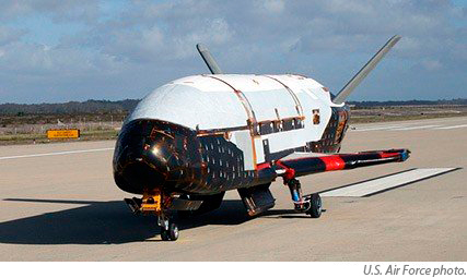
    The OTV-2 launch comes on the heels of the successful flight of OTV-1, which made an autonomous de-orbit and landing at Vandenberg Air Force Base, California, on December 3, 2010, after successfully logging 224 days in space, something for which the current NASA manned space shuttles were never designed  and are unable to accomplish. According to USAF officials, post-flight analysis of OTV-1 revealed OTV-2 needed no significant changes, and the second X-37B flight is aimed at helping Air Force scientists better evaluate and understand the vehicle’s performance characteristics and expand upon the tests from OTV-1.

    The spacecraft measures more than 29 feet long and nine-and-a-half feet tall. Its wingspan is 14 feet, 11 inches, and it weighs approximately 11,000 pounds at launch. The objectives of the OTV program include space experimentation, risk reduction, and a concept of operations development for reusable space-vehicle technologies.
    x-37B
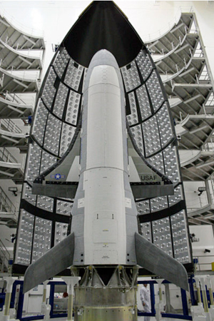
The X-37B OTV is America’s newest and most advanced re-entry spacecraft. Based on NASA’s X-37 design, the unmanned OTV is designed for vertical launch to low Earth orbit (LEO) altitudes where it can perform long-duration space technology experimentation and testing. Upon command from the ground, or as preprogrammed, the OTV autonomously re-enters the atmosphere, descends, and lands horizontally on a designated runway. The X-37B is the first vehicle since NASA’s Shuttle Orbiter with the ability to return experiments and surveillance sensors to Earth for further inspection and analysis.

    The X-37B OTV is a military autonomous space vehicle, and that is where the excitement resides. It brings back memories, from around 1959, of the promised but unfulfilled capabilities of the early Boeing Dyna-Soar or X-20 (yes, I spelled it correctly) space and atmospheric skipping vehicle and, well… just use your imagination. Early estimates are the X-37B OTVs could actually stay on orbit for more than a year if necessary. That sounds like a real time, persistent space surveillance platform/sensor to me, just to name one option among a list of many valuable military missions. I suspect we will be hearing about many more amazing feats and record flights concerning the X-37B or not; and because I attended the NSS I actually got to see the real article up close and personal…that alone was worth the price of admission.

    NSS Presentations

    Certainly the presentations at the NSS are not to be missed, but you have to plan your time carefully since there is so much to see and do. Just roaming the halls of the multiple exhibition areas (four this year) is an education in itself, and you just never know who you are going to run into. Former and current astronauts abound, and senior officers from all services will freely stop and chat with you about the various exhibits and their pet programs. Treat them to beautifully hand scooped ice cream at AGI or a hot Italian Cappuccino at the LMCO booth and who knows what you may learn.

    National Strategic Infrastructure versus LightSquared
    480px-Gen_William_L_Shelton
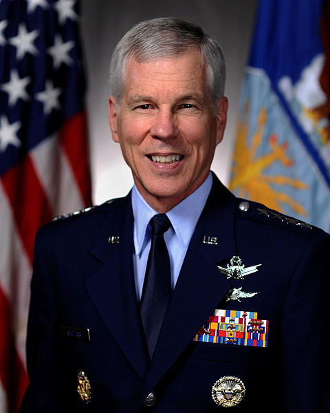
As I mentioned in my NSS blog, the whole event, both the Cyber and the Space Symposiums, were kicked off by my old friend and colleague General William L. Shelton, the commander of Air Force Space Command. General Shelton tends not to be long winded — in other words, his
    speeches are brief and to the point, and historically right on target. His presentations at the Cyber and Space symposiums were no exception.

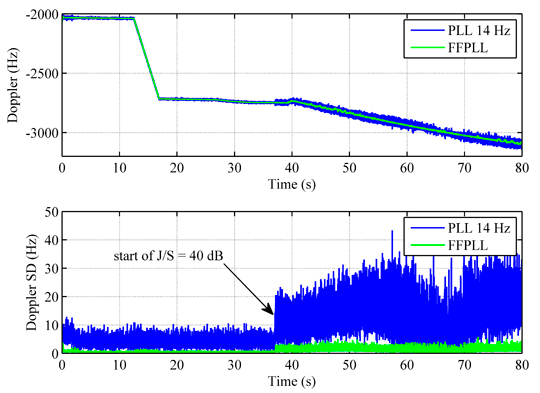
    General Shelton took on the new and emerging cyber threats, the future of space with a flat or declining national security space budget, and of course the imminent national GPS threat from LightSquared. As the steward of GPS and as a warfighter himself, General Shelton is the only four-star officer from any service that has manned up, stood tall, and been counted on the LightSquared issue, which is an ominous harbinger (pun intended) of a possibly disastrous future for our warfighters and first responders (see PDF report) — actually, it poses a threat for all GPS users in the U.S. The LightSquared debacle is led by a Luddite administration where no one has the guts to tell the commander-in-chief he has no clothes, or a clue for that matter, when it comes to military or first-responder PNT related technology. Just ask Seal Team Six how important GPS and all the capabilities that GPS enables was to their successful mission taking out Bin Laden. But of course this administration has a history of denying critical PNT-related support to the national strategic infrastructure. Just think back to the eLORAN fiasco, and now there is the LightSquared debacle with the potential catastrophic denial of GPS signals across the United States, or you may wish to refer to it as FCC-sponsored nationwide GPS jamming as I have often heard it described.

    In my opinion, the whole LightSquared issue is ludicrous and borders on the criminal. If LightSquared and inept FCC commissioners, who can’t spell space, have their way, our warfighters and first responders will not be able to train the way they fight in the U.S. or for that matter “… defend the United States against all enemies foreign and domestic…” which, to the best of my recollection, they are sworn to do, and LightSquared would cripple that ability. And this is how the loss of GPS signals across the United States applies to you and me on a daily basis. When you are having a medical emergency, say a major coronary, the short-staffed paramedics will no longer be able to find your home in time to save your life, and the undermanned fire department won’t arrive until your home has burned down or the over-burdened police department won’t arrive until the burglars are long gone, because they will be too busy looking at outdated paper maps trying to determine where you live. And don’t get me started on undermanned FAA control towers, the potential loss of next-gen, GPS enroute navigation, approaches, departures, and sleepy overworked controllers. The entire future of the FAA and our air travel in the U.S. is based on satellite navigation and in the U.S. that means GPS. That is now at risk plus the millions of dollars and jobs that will be lost because of LightSquared. GPS is and always has been a recognized force multiplier and without it critical service providers across our nation will become even more short-handed. and he U.S. could loose over $100B in revenue annually. All so young people, who are mostly too young to vote Mr. President, can have a broadband signal to browse the Internet and play games in the middle of Kansas, or of course the all-important ability to download, read, and comment on those Congressional Bills awaiting the President’s signature…just another promise by candidate Obama that has never materialized. Don’t hold your breath. Write your congressman now.


    LightSquared Webinar Set for May 26, 10 a.m. PDT

    A panel of experts will discuss findings contained in the May 15 status report by the FCC Technical Working Group on LightSquared/GPS Interference Issue. The TWG’s third report is anticipated to include at least some testing results of GPS receivers under LightSquared conditions: terrestrial transmitters in the L-1 Band (1525 MHz–1559 MHz) immediately adjacent to the band (1559–1610 MHz) where GPS and other GNSSs operate. Webinar panelists will represent the high-precision sector, aviation, consumer handsets, and timing infrastructure. Register today.


    NSS Speakers

    Alas, I digress, so let’s step off the soapbox momentarily and move on to more positive happenings at the NSS, but you haven’t heard the last of LightSquared. If only we were so fortunate. Onto the outstanding agenda of presentations… There were almost 100 speakers at this year’s Space Symposium, and if you count the Cyber Space presentations there were well over 100 speakers, some with topics more interesting than others of course, but all the presentations I attended were professional and at a minimum engaging and focused on the future of the space enterprise. Unfortunately you could not go more than five minutes without a speaker expressing his or her opinion, or someone asking your opinion, about the LightSquared debacle. At least I can say that regardless of the opinions, they were certainly passionate.


    Bottom Line At The End: BLATE

    So the bottom line on the NSS is if your interests, personal or business related, are in the National Security Space arena, then the NSS is the place to be. A time-sensitive agenda with interesting and high-level presentations, exhibits from the world’s leading space companies, networking opportunities that are second to none, and all in a venue that King Arthur would love. Truly the Broadmoor accommodations, the courteous and professional staff, the excellent cuisine, and the breathtaking views are second to none. Plan now and see what all the fuss is about at the “Premier Gathering of the Global Space Community,” the 28th National Space Symposium, in the foothills of the Rocky Mountains, April 16-19, 2012.

    GPS Partnership Council

    Fast-forward a mere two weeks and now we are attending the AFCEA (Armed Forces Communications and Electronics Association) sponsored 10th Annual GPS Partnership Council at SMC, Space and Missile Systems Center, at Los Angeles Air Force Base in California. This event, which was successfully and artfully resurrected four years ago by the then GPS Wing Commander, Colonel David Madden, has carried on under the auspices of Colonel Bernie Gruber, the current director of the newly designated GPS Directorate. Managerially sponsored by the local AFCEA chapter with funding provided in the most part by numerous GPS primes and their sub-contractors, this is a first-class event you need to attend if you are a hard-core GPS groupie. The folks at AFCEA ably aided by Colonel J.B. Borris (USAF Reserves), the indomitable event chairman for four years running, and his team — especially this year’s narrator extraordinaire, Captain Tiffany “Tupperware” Ware, who fortunately had a great sense of humor, which certainly comes in handy with this crowd — put on another memorable council. Frankly, even though I fondly remember the old GPS Partnership Councils, pre-Madden, they do not hold a candle to the content and professional first-class events of the last four years. If you are a military, civil, or commercial GPS/PNT professional, or work in a GPS-related industry, then the GPS Partnership Council in Los Angeles is where you needed to be last week, and it is never too early to plan for next year’s event in May 2012. One old-timer I overheard explaining this event to a newcomer said it this way: “Think of this as a joint military, inter-agency, civil, and comm
    ercial get-together of GPS subject matter experts.” That works for me.

    While the venue is two hours west by fast jet and about 6100 feet lower in altitude than the NSS, the same professionalism still prevails. Of course this event is GPS centric and since GPS is so ubiquitous in our everyday lives, we should all take note of the news coming from this important event. While it is only 1/45 the size of the NSS, it is no less important to those who depend on GPS as their raison de vivre. This years’ theme was “Executing Modernization…Enabling New Paths and Beyond.” However, I enjoyed General Robert Rosenberg’s comment, during his rousing remarks relating to the way ahead in a fiscally restrained environment, that the theme might more appropriately be taken from one of Winston Churchill’s famous quotes during WWII, “Gentlemen, we have run out of money. Now we have to think.”

    The speakers at this years’ event, especially General Rosenberg, were on the whole outstanding from the introductory comments by Lt. Gen. Tom Sheridan (USAF), SMC/CC, who will be hanging up his military spurs later this month, encouraged us all to have a good time and left us with a quote from the International Academy of Astronautics, which has declared that to date “GPS is the space program that has proven the greatest human benefit in the history of space.”

    Just after General Rosenberg’s wonderful invigorating and thought provoking lecture, and yes he included the LighSquared debacle, a very senior and well-known member of the audience, who was speaking to me as a colleague and friend and not as a journalist, so I will respect his wish for anonymity, expressed his dismay that… “a private for-profit company should be allowed to wreak such havoc on our critical national infrastructure… it is simply criminal. Why doesn’t someone in the military speak up? What is wrong with this administration? Do you think the President is not aware of the potential devastation he has wrought? This whole LightSquared issue just makes me ill.” I could not have said it better.

    Warfighter Panel

    While it was great to hear about the proclamation by the International Academy of Astronautics, the awesome warfighter panel presentation on the last day of the GPS Partnership Council was in my opinion the highlight of the event. To see and hear how the panel of Army Rangers, Navy SEALs, USAF Special Operators, and USAF aviators and others actually use GPS not only to accomplish their missions but to save lives every day is exciting. The warfighter panel provided feedback on how warfighters’ lives depend on GPS, and as a former warfighter the moving presentations made my chest swell with pride and brought a tear to my eye. These young men and women are going in harm’s way and they deserve the best equipment and support we can provide. At the end of the day the warfighter panel received a much-deserved standing ovation and I was proud to be in the audience. I hope they caught it on video so you can all experience it someday. Emotions were running high to say the least.

    Extras + Networking

    Just as during the NSS, the networking opportunities at the GPS Partnership Council were abundant and rife with potential. Plus fun was had at the biggest networking opportunity of all, the annual golf tournament, where you get to rub shoulders and compare bogies, with a who’s who of the GPS community; plus the now traditional libation-fueled networking event at “Shade” was a fun time for all who attended as well.

    Exhibits

    Certainly the exhibits at this event are at a minimum, but the companies that do exhibit have a very interested, attentive, and GPS-educated audience. If I were running a GPS/PNT/GNSS centric company, I would definitely want to be there as an exhibitor, because 100% of the audience is greatly interested in what you do. While current exhibit space is somewhat limited, there does appear to be room for expansion if needed. The biggest challenge at this event is a common one in California and that is parking, but there was a plan and it worked well as far as I could determine. I did not hear any complaints.

    Boeing II-F Factory Tour

    Since you are attending a GPS event at the home of GPS acquisition, opportunities for additional information abound with the large prime contractors in the area that support GPS, and this year as in the years past we were able to take advantage of that circumstance. This year wearing a slightly different hat I, and several of my think tank colleagues, visited with Ken Torek, the vice president for Navigation and Communications Systems & Space and Intelligence Systems, and his staff, which included Jan Heide, the new Boeing GPS Program Director, at the new Boeing GPS II-F facility in El Segundo, California. We were given the VIP treatment and were able to see IIF satellite vehicles three through seven, all in various stages of completion on the innovative, labor, and cost savings Boeing Pulse Line. In this configuration the satellite comes to you in a fashion that would make Henry Ford proud. While on our tour we learned that SV IIF-2 has already been shipped to Cape Canaveral, Florida, for a launch scheduled sometime in July. We also learned this will most likely be the only II-F launch in 2011. Since there are 31 active satellites on orbit, with three residuals and one in standby mode, the launch schedule has been moved to the right with the lack of urgency resulting in one GPS launch per year for the foreseeable future. Barring a catastrophic event on orbit, this will most likely be the future of GPS launches for the life of the II-F program. As previously predicted we will most probably witness several IIIA launches (built by LMCO) before the II-F launches are complete. My hat is off to Boeing for a great afternoon of briefings and tours, plus here’s hoping for a successful IIF-2 launch in July.

    PRNs and Accuracy

    During the council the USAF and DOT announced that they would be removing the PRN-1 number from SVN-49 (the one with spurious signals that has been placed in standby mode) and releasing the test PRN for use with IIF-2, that when launched in July will utilize PRN-1 while it is being checked out. Once operational, another PRN will be assigned that will be especially helpful for precision users (surveyors and such). Since the ground command and control system cannot currently handle more than 31 PRN’s, for reasons not appropriate to this venue, (a problem that will supposedly be fixed by OCX in 2015) this means that SVN-49 will be placed in residual status for now and in all likelihood also means another SV will be placed in residual status as well, bringing that total number to five SVs in residual status. When I checked this move with other sources they were quick to assure me that this does not mean they have given up on SVN-49 and indeed they hope to find a way to make it a fully functioning member of the GPS constellation in the years to come. No timetable for that move obviously. But I was assured they are still working the issues.

    Since the single on orbit instance of the II-F SV is proving to have an extremely accurate clock, hopes are that IIF-2 will follow by broadcasting a more accurate timing signal, which translates to more accuracy on the ground. Remember from MEO one nanosecond of timing accuracy equates to one foot of position accuracy on the ground.


    Another Civil Focus Day?

    Colonel Gruber announced that General Shelton, the current AFSPC/CC will more than likely follow in the footsteps of General Kehler, the former AFSPC Commander, and announce a follow-on Civil Focus Day most likely to be held at Air Force Space Command sometime this year. The first resurrected event of it’s kind in about ten-years, it was a big success in 2010.

    <e
    m>GPS-IIIA: OCX Updates and the Gap

    Colonel Gruber provided us with an update on the GPS-IIIA program by Lockheed Martin, which is on track for the first GPS IIIA launch sometime in 2014, and an update on the Raytheon OCX program, or new GPS ground Command and Control system, due to be operational sometime in 2015. While Colonel Gruber is happy with the way both contracts are progressing, in my opinion we still have the famous “gap” that everyone goes out of their way to explain is not really a gap, but in new government speak as proclaimed by a pundit from the stage during the National Space Symposium, what we really have is “negative operational margin.” But seriously it is still a gap, no matter how you characterize or spin it and one that still needs to be closed. And yes I know all about the plan to fill the “gap that doesn’t exist” with the new LCS (Launch and Checkout System). While I don’t object to LCS per se, I do object to the way ahead as currently envisioned by SMC. There is in my opinion an extremely clear way ahead for LCS; why not use the same incredibly reliable, low risk, and very affordable independent LADO (Launch/Early Orbit, Anomaly Resolution, Disposal, and Operations (LADO) System, built by Braxton Technologies, that the USAF used for the IIA, IIR, IIRM, and IIF SVs and is the only technology that allows us to operate residual satellites today? Can you say past performance matters? Can you understand excellence and low risk are key performance parameters? Alas, on this issue the acquisition community for some reason beyond my ken cannot, and now the politicians and cost accountants are involved. Indeed, it has become the dreaded forest for the trees sort of issue. I’ll do my best to keep you updated. And I would very much like to say that surely reason, logic, and common sense will prevail, but then I inevitably think about the LightSquared debacle and I am not at all sanguine about filling the gap, excuse me, the negative operational margin, in a logical or timely fashion with the current plan in place. For the same reason I am not sanguine about the U.S maintaining GPS as the Gold Standard for the world. Can you spell insanity? L I G H T S Q U A R E D or just abbreviate it as F C C, take your pick.

    Constellation Update

    Colonel Gruber’s constellation update read like this (comments are mine):

    Status of the Enhanced 24 GPS Constellation

    • 35 total GPS satellites on orbit (Most ever on orbit)
    • 31 total GPS satellites set healthy (Max for AEP)
    • 3 residual GPS satellites (enabled by LADO)
    • 1 standby GPS satellite (SVN 49)
    • IIA – 11 GPS satellites on orbit (average life 16 years, oldest 20 years)
    • IIR – 12 GPS satellites
    • IIR (M) – 7 GPS satellites
    • IIF – 1 GPS satellite

    It was a very uplifting and “good news” presentation right up to the point where someone in authority hinted that the entire GPS Modernization effort being briefed by Colonel Gruber was in danger due to the LightSquared debacle. Do you sense an underlying theme?

    GPS Hall of Fame

    At the end of Colonel Gruber’s presentation we all had a nice surprise when he inducted the distinguished aerospace engineer  William (Bill) Feess from Aerospace Corporation into the GPS Hall of Fame. Bill has been a stable and guiding force at Aerospace for the last 48 years with many of those years spent in the GPS arena dating from the 621B era. A well-deserved honor for Bill and the Partnership Council was the perfect venue for the award.

    Rockwell Collins

    During one of the numerous networking breaks I ran into Trevor Overton the Principal Program Manager for Surface Navigation Programs and Government Systems at Rockwell Collins, the company that produces the DAGR or Defense Advanced GPS Receiver. Rockwell Collins had a large booth and display, as they do every year and they were well represented in the DAGR and micro-DAGR arena by Gina Krug who serves as the Principal Account Manager for Precision Navigation and Government Systems. Mr. Overton is the one that got my attention however because somehow his title translates into the engineer who is in charge of the embedded side of the GPS operations at Rockwell Collins and he let me know rather quickly and in no uncertain terms that he had nothing to do with the handheld DAGR but worked solely with embedded systems. Then he showed me the fruits of Rockwell’s latest endeavor, the MicroGRAM, a new embedded GPS with GPS SAASM (v3.7) chip that area wise is about the same size as an SD chip, 19 mm sq, but about three times as thick since it is built with 90 nanometer technology. It has solder points for embedding on a systems board by OEMs (original equipment manufacturers) and is 12-channel capable. However, it was the near SD size that intrigued me. While embedded works and I hope they sell a ton of them, being able to slide this GPS + SAASM chip capability into an SD slot on any device with an SD slot, an antenna and a display is very appealing and constitutes a capability the war fighters have been asking for and could benefit from today; but Rockwell tells me there would be significant security issues with this approach. More on this chip in a later article when I have had a chance to visit Rockwell Collins and see what the future holds. Iowa in the Spring sounds doable.

    GPS and Seismology

    There was a very interesting briefing on what is now known as the Tohoku earthquake and tsunami in Japan. Seismologist have apparently settled on a 9.0 rating on the Richter scale, which is the fourth largest earthquake on record since 1900, with enough power was generated to power the entire planet for 40 years if someone could figure out a way to harness all that raw power. The Tohoku earthquake and tsunami are catastrophic events that Japan and the world will long remember. Undoubtedly there will be lessons learned, especially in the nuclear power plant protection arena. In the briefing at the GPS Partnership Council, we learned that Japan had prepared as best they could from a geodetic warning point of view by building more than 1,000-networked GPS receiver sites known as GEONET. It was hoped that GEONET would provide warnings of cataclysmic seismic events, but the system experienced a real-time telemetry failure, as in it is hard to transmit when your antennas are under a hundred feet of seawater. However, now critical GPS data from the event are being retrieved and processed so there are still valuable lessons to be learned even in a post-processing environment. One of the most impressive graphs of the data shows that just prior to the tsunami the GPS monitoring stations around the Sendai area of Japan actually shifted to the east by four meters. I was shocked by that information. You might expect four centimeters or four inches of movement but four meters represents an event of catastrophic proportions in the seismology world, and indeed we have all seen the results on the nightly news. Obviously the GPS seismology data is crucial to future earthquake planning and even to earthquake-proof building codes around the globe. Consequently, in the future in Japan and in the Unites States we can expect to see GPS used co-seismically as a real-time monitoring and warning tool. The question is how do you make the seismology warning system survivable to a four-meter (~12 feet) physical displacement and able to survive a 125-foot wall of seawater moving at jet speeds?

    Garmin Has a Deal for You

    During another of the networking breaks I was introduced to Rick Evans, a former Marine, who serves as the business development manager for government and law enforcement at Garmin, in Olathe, Kansas. Since Garmin does not have a designated military division, this is as close as it gets. It is a
    well documented fact (we have a database of more than 8,000 responses to surveys and interviews) that a huge majority (>95%) of our warfighters use Garmin or other civilian, commercial equipment in theater because it works, meets their needs in a non-jamming environment, and has a very user-friendly interface. I plan to follow up with Rick and possibly visit Garmin, but I want to pass on a bit of interesting and valuable information to our warfighters and first responders. If you fit in either of those categories, there is a website just for you that allows you to order Garmin equipment at a considerable discount. But again it is only for warfighters and first responders/law enforcement, and you can find it at Strohman Enterprises. More on this at a later date. Let me know how this works for you if and when you order from this site.

    Future Events

    I’m running out of airspeed and space but I do want to mention two upcoming Colorado events I will be attending in June and you should attend if you are interested in GPS and the warfighter or from a first-responder perspective. The first event is the Space and Cyberwarfare Symposium in Keystone, Colorado, June 14-16. This will be the sixth year for this up-close-and-personal gathering of space and cyber experts. This year’s theme is Space and Cyberspace Innovation: Leveraging the Enterprise to Win the Joint Fight. And of course today it is all about the joint fight. Even the Seal Team Six raid in Pakistan was a joint endeavor. I’m sure we will hear more about that at the Symposium.

    My favorite parts of this symposium are the small size and the access you have to senior decision makers who are far away from their office and phones and able to relax in the Rocky Mountains. There are extended networking sessions between briefings that provide you with plenty of opportunities to connect. Plus, do you know how much farther a golf ball flies at 10,000 feet? It really makes a difference. So you can probably predict my next favorite features are the venue and the people involved. This professional and educational yet relaxed atmosphere event is very well put together and you will be happy you attended. Come join me as I ride my mountain bike alongside the roaring Snake River — with GPS attached of course. Hope to see you there.

    ION

    The next event is the annual ION (Institute of Navigation) and JSDE or Joint Services Data Exchange co-sponsored Joint Navigation Conference (JNC), which will be held in Colorado Springs, Colorado, this year and next. This year’s FOUO events take place June 27-30 at the Crown Plaza Hotel, while the classified session on June 30 takes place at the Elkhorn Conference Center located on Ft. Carson in south Colorado Springs. According to ION officials, this year’s JNC will be the largest U.S. military navigation conference of the year, with joint service and government participation. The event will focus on technical advances in positioning, navigation, and timing (PNT) with emphasis on joint development, test, and support of affordable PNT systems, logistics, and integration. From an operational perspective, the conference will also focus on advances in battlefield applications of GPS, critical strengths or weaknesses of fielded navigation devices, warfighter PNT requirements and solutions, to include navigation warfare. Plus the classified warfighter panel on June 30 at Ft. Carson (USA) should be enlightening because the warfighters are free to speak in a classified environment (SECRET) and relate details and experiences that would not be possible in a public forum. So go online and register today and don’t forget to have your security manager send your clearances and join us for the warfighter panel.

    So June looks like it is a busy month for PNT professionals. I hope to see you all in the Rocky Mountains. Until next time, happy navigating.


  • Mobile Epiphany – Round Two

    Don Jewell
    Headshot: Don Jewell

    Many of you may remember my one and only software review of a product called Touch Inspect back in December 2009, by a Denver, Colorado (Aurora)-based company called Mobile Epiphany. At the time this is how I began my initial brief review of the software program:

    “The software is called Touch Inspect, and it is essentially a computerized, geospatially aware, data-collection application with an amazing user interface. But having said that, just so you understand the basic intent of the program, I have to also say that it is so much more than a computerized data-collection application. Calling Touch Inspect a typical computerized data-collection application is like comparing a skateboard to a Ferrari.”

    At the time I promised an in-depth review the software “real soon.” Well, real soon has turned into 16 months, and not a single week has gone by that I have not received several e-mails wanting to know more about the software and asking when the next review would be published. So for all of you who have been waiting, this is the promised in-depth review of Touch Inspect version 2.0, which the company now promotes as customizable software tools under the more apt heading of “Mobile Business Process Software.” But the base program is still known as Touch Inspect.

    Bottom Line Up Front — BLUF

    When you brief senior military officers today, as I have occasion to do, it seems that they all want the first chart to be the BLUF chart. It is a version of the old military briefing idiom that goes like this: Tell me what you are going to tell me and then tell me and then at the end tell me what you told me. So I will start by saying that my original assessment of Touch Inspect has not changed, unless it is to have become even more enamored with this incredible software. I have an even broader vision of its uses, especially for warfighters, whether their primary function is combat, maintenance, inspection or logistics. This software applies to first responders as well. You be the judge.

    Versatility and Visions

    When I was first briefed on this unique software program back in 2009, my first thoughts were that this is indeed a great inspection software program, but I can think of so many more uses for it. My first thought was that it would be wonderfully useful as a mobile IED (Improvised Explosive Device) database, inspection, and information-gathering program. In fact, it was so obvious that I was off wool-gathering about IED databases during the briefing that the CEO of Mobile Epiphany, Dr. Glenn Kletzky, stopped his presentation until I rejoined the real world. But this is what hearing about this incredible software does to you. It makes you think of all the possibilities and capabilities it makes available to our warfighters and first responders. I was happy to hear from Glenn that my reaction, thinking that Touch Inspect is so much more than a top-notch mobile inspection tool, was to become a commonplace reaction amongst almost everyone who saw or heard about the software.


    Today, Touch Inspect, running under numerous pseudonyms, is being utilized by our government and others in ways we just can’t discuss in this venue. It is being tested and/or used in the construction industry, in oil and gas operations and exploration, in utility related industries, in the telecommunications industry, in human services and tracking, as well as in healthcare, just to name a few of the myriad user communities. There are other users that I am not allowed to list because this software really gives you an unfair advantage over those not utilizing its considerable and unique capabilities. Suffice it to say that almost everyone who views a demonstration of this extremely flexible asset and process/procedure-focused software thinks of something useful for it to accomplish, and sometimes it even involves inspecting something.

    My first thoughts of using Touch Inspect for activities surrounding IEDs has evolved considerably. Not only can the Mobile Epiphany software be used to house an interactive mobile database with all the knowledge we have gained about IEDs, but when the software is running on a rugged mobile device with GPS, communications, and cameras, as well as other sensors, it enables the user to:

    • Take a picture of the device and annotate that image
    • Look up other items in the database with automatic prompting of what the user should look for
    • Instruct the user how to interact with the IED (other than the obvious precaution of ‘run’ or proceed very carefully)
    • Assist users in identifying the type of IED and the associated dangers
    • Automatically gather data such as location to include GPS or specific grid coordinates, altitude, and heading and whether other IEDs have been found on the same site previously or in the surrounding area and can automatically identify those locations on an internal or externally obtained map
    • Record the time of the observation and the position of the observer, for review at a later date.

    If the IED is a common type or one seen previously by EOD or Explosive Ordnance Disposal personnel, the software can be configured to instruct the user on disarming the device, if he/she is crazy enough to do that, and if disarming is indeed an option; it does all this with preprogrammed software that ensures all the necessary data is collected. If the user is a novice, which can be automatically determined by the user’s login and granted permissions, the software can automatically prompt the user at every step, or in the case of an experienced user, the software can make use of an accelerated or “fast-flow” mode that eliminates many of the more basic steps or procedures and gets to the required data collection and instructional screens without delay.

    In short, the software is flexible in the extreme, to the point that I can make the statement that I see uses for it every day, especially for our warfighters and first responders, and I sincerely hope that it makes its way into the .mil applications store for the DoD soon. It is a software product and capability/advantage our warfighters desperately need.

    Platforms

    When I wrote my first review, the Touch Inspect software (version 1.0) ran only on handheld devices that used the Windows Mobile Operating System. Today, it runs on all versions of Windows Mobile (5, 6, 6.1 and 6.5) as well as running on all versions of the full Windows operating systems (XP, Vista, and W7). Furthermore, the full Windows version of Touch Inspect runs on all PC-based slates and tablets in either orientation (portrait or landscape) and can be resized from full screen to a minimal window size, thus sharing the screen with other applications.

    Today the software is also in the process of being ported to Android and Apple platforms. The Android operating system versions will be released in the third quarter of 2011 and the Apple versions will be released in the fourth quarter of 2011.

    Although Mobile Epiphany is growing by leaps and bounds, according to Dr. Kletzky, I predict that the company will really take off when the Android and Apple versions hit the street. If you can’t tell, I am as excited about this software as I am about my iPad and
    iPhone because it will take the usability of these highly desired and much utilized mobile platforms, especially for warfighters and first responders, to new heights. The software and hardware combined will present an awesome potential that will greatly enhance our warfighters’ and first responders’ productivity and safety. For example, since these are the most popular and prevalently used devices in theater, the U.S. Army is considering a plan to provide Android and Apple mobile devices to the warfighters. So why not provide the warfighters with the very best and most flexible software, along with its very friendly user interface as well? Provide the warfighter with devices and software that they will actually use and customize to their needs. The combination of top-of-the-line mobile devices and Mobile Epiphany software will save time, money, and lives. But, of course, Windows is already in very wide use today throughout our armed forces, and this software is ready right now to help those existing users.

    I’m convinced the combination will prove to be an invaluable tool for mission planning, data collection, intelligence gathering, and post mission debriefs, as well as a tool for the everyday tasks that must be conducted in a prescribed manner — such tasks as pre-flights, repair procedures, facility and equipment inspections, and anything else that requires a complex procedure or checklist today. I don’t want to dumb down this versatile product and call it an automated and/or interactive checklist, because that is just one of the more mundane but important uses of the software. And I don’t want you to forget the instructional capability of the software. You can have complex procedures where every step is accompanied by multiple reference high-definition media to ensure success at your task, like a parts blow-out or a wiring diagram, right on your mobile device. Whether you need to learn a new complicated business process or a new series of military procedures, the Mobile Epiphany software has the ability to take you through it step-by-step flawlessly, with seemingly endless potential branches in any scenario, until you are confident that you have mastered your task. Glenn Kletzky explained it this way: “Once you have procedures or processes of any sort established, and you have users who perform and confirm those steps on paper or on screens, it is then just another small step to convert those steps, complete with branching logic based on a user’s input, into Touch Inspect.”

    “Although it is critical to ensure quality data collection and disciplined procedural adherence to process, it is also a step ignored by most software programs,” Kletzky said. “Once these steps are rapidly configured into the Touch Inspect’s Business Process design tool in combination with the available branching logic capabilities, viola! you have a process that can be customized to the user’s needs.”

    The Algiz 7 running Touch Inspect.


    The Real Deal

    Never being one to totally trust marketing hype, I showed up at Mobile Epiphany’s facility a few weeks ago with three very different GPS-enabled mobile computers. I brought the latest Trimble NOMAD, being used by thousands of our warfighters today, a borrowed first-generation GD (General Dynamics) rugged MR-1 computer, which I reviewed for our readers two years ago in April 2009, and the most recent computer I reviewed, just last month in fact, the Handheld Algiz 7. I then challenged Glenn to load version 2.0 of the Touch Inspect software on all three machines and we would see how they fared.

    So while Glenn was giving me the latest updated briefing on and future plans for the Mobile Epiphany software, his technicians loaded the software and the results were amazing. The rugged GD computer was the oldest machine, being a very early version (Hint: there is a much more modern and totally waterproof version of the MR-1 available today from GD). My borrowed device is several years old and still operating with an antiquated version of the Microsoft XP operating system, with a small amount of RAM, compared to today’s latest machines. But once loaded, the Mobile Epiphany software screamed on the machine. Everything from zooming in on annotated images, slipping and zooming in on maps, rolling through flick lists of assets, etc., all animated smoothly. It ran as fast, once loaded, as the two newer machines, which sported much faster processors and double or triple the RAM. This just goes to prove that the software does adapt well to various platforms and operating systems. You don’t need to have the latest and greatest hardware and tons of RAM to run this software. That to me is a testament to the hard work the Mobile Epiphany software engineers have put into making this a truly adaptable mobile software tool, that really comes alive on a PNT-enabled device.


    The GD MR-1 running Touch Inspect.


    Adaptability

    For those of you who are saying, yeah, great, sure it is customizable, but I don’t have millions of dollars and months or years to customize the Touch Inspect software to make it do what I need it to do. Oh contraire, mon ami. On-the-fly process and workflow customization is another major strong suit of this software, and it differentiates it from any other software I have ever used.

    Dr. Glenn Kletzky is actually the CEO of two very successful IT companies, Mobile Epiphany and iBeta. iBeta is a 12-year-old software quality assurance and testing laboratory for software ranging from enterprise class applications for government all the way to the video game industry. And he and his team have been at this for some time, and they have experienced the agony of the software development life-cycle (SDLC). It is not uncommon for robust mobile applications which include geospatial and process capabilities to require no less than 18 months to design, develop, test, and fix prior to being ready for deployment. Additionally, the SDLC requires a team of skilled programmers and testers to meet those deadlines. And even that speed can only be achieved using tools known as Rapid Application Development or RAD tools. Glenn likes to say, we (Mobile Epiphany) took that process from 18 months to 18 hours, and the 18 hours requires no software developers. All that is required is a subject matter expert (SME) in the field for which you are customizing the software and a single person who knows how to configure the process using the technology’s easy-to-use configuration toolset. Yes, you heard me right: just 18 hours versus 18 months. Talk about time, cost savings, and flexibility.

    Mobile Epiphany accomplishes this feat through a process known as Rapid Application Configuration or RAC, and it is possible because of Mobile Epiphany’s new approach to rapid application creation and deployment. You do not have to go through the traditional lengthy process of designing the application itself and the screen appearances, or even the work flows. This is because the application and all the relevant workflows required for a geospatial, process-based application already exists. The software has already been designed, developed, and tested. The person in charge of configuration simply “configures” the application (easy to learn — no programming at all) with a rapid customization tool included in the
    configuration tool set, known as the “Business Process Designer.” And this configuration tool, along with others, can be learned by non-programmers in a matter of a few hours. This means our warfighters, who already customize and download specialized applications on their non-government mobile devices, can now totally customize Touch Inspect software via the RAC process, on the fly, in the field, in less than a day, to do exactly what they need it to do. And after one person configures the work flow or process required, it can be sent wirelessly or by wire to two or two thousands other users. I know this sounds impossible and too good to be true, but I have personally observed the process and then customized the software myself, and believe me if I can do it, anyone can. And the beauty is that the customization process and version control are seamless. They appear to the user to just be another part of the application because they are, and that is a large part of the appeal of the Mobile Epiphany software.

    What makes Mobile Epiphany Software So Different?

    When I asked Glenn how he had managed to develop software with such incredible and user-friendly capabilities, he simply said: “We listened to our customers and our users, and we figured out a way to simplify the process of giving them what they need. They asked for powerful and flexible software with a friendly user interface that could be customized in the field, on the fly and that’s what we gave them.” It should be noted that Glenn worked with video-game designers in his company, who are not programmers, to develop the entire interface.

    Now- anyone in the software business knows that in order for a powerful software program to accomplish useful work and still be simple to operate, there must be a tremendous amount of capability hidden inside an intuitive interface with a definable hierarchical process and this is what Mobile Epiphany software epitomizes.

    So indeed Mobile Epiphany has built a very useful business process software tool that incorporates:

    • Robust hierarchical lists with image and data lookup built-in. After all, images can be a big part of the procedural discipline and data collection and process.
    • A powerful and advanced branching logic engine: think Boolean logic and powerful and/or <> = rules and searches made easy.
    • Using math as a method to determine branching logic requirements, and making math easy and natural for the user.
    • Ensuring there is a hierarchical approach to everything (if you require it) with drill downs at every level to ensure you won’t get lost in the process.

    To add authenticity, intended use specificity, and ownership for the user, Mobile Epiphany spent hundreds of programming hours making it easy for the user to “skin” or customize his own application’s appearance. It is all Touch Inspect underneath, but it can make the interface appear to be user purpose specific, with art placed onto the interface not only as a user trademark, but also as an integral part of the buttons they press to complete their unique workflow and process. Indeed, with the Mobile Epiphany software, customer branding can be displayed in many ways, obvious or subtle, on every screen if necessary, and it can all be accomplished within the confines of the original software. As the saying goes today, there is a GUI (graphical user interface) and/or an app for that, and in this case they are built-in.

    For example, if a fire department is using the software, the program displays an almost endless variation of maps and/or floor plans plus a database of chemicals that have toxic fumes when exposed to heat. Both maps and encrypted data can be stored directly on the device (no network connection required in order to keep working) or it can be brought in through secured online connections (real-time) to map and data servers. The software readily accommodates PNT (position, navigation and timing) inputs, as well as geospatial information system data, from numerous sources, and seamlessly incorporates those inputs and displays the information as needed by the user, in more ways than you would imagine. The system’s server even has a complete set of web services and APIs (application programming interfaces) so that the data trapped in legacy systems and only accessible through fixed terminals can now be made mobile through integration to the Mobile Epiphany servers.

    If you want or need more diversity, then rapid customization on the fly is only a few hours away. You don’t need a separate development team or costly software development program. All the customization capabilities are built into the Mobile Epiphany software, and you can test the results of your changes as you go along. Remember, all that’s required are the subject-matter experts who have a process that needs to be made mobile. The software also features a powerful report-building and report-running tool, a business process design tool for rapid application configuration (RAC), an enterprise description and security administration tool so that you can decide who in the organization (or what group of people) can gain access to which data, as well as a data exploration tool for rapid look-up of data via an easy-to-use query engine.

    Reports

    All the customization and rapid configuration tools and capabilities sound great, but what about the reporting tools? What happens when you need to interface with the office IBM mainframe or a distributed military server network and then need to print or produce reports in a standard format with legacy reporting requirements? Not a problem; the Mobile Epiphany software can integrate to any legacy system on the company server or network seamlessly and produce reports in most all required formats.

    There are web services and APIs (application programming interface), which allow the software to be integrated to any other existing system or network. It is a combination push-and-pull process. While the software does not need any other back-end system to function (it is a full, end-to-end system), it can also function as powerful middleware for existing systems. The way Touch Inspect collects data and tracking geospatial metadata, it retains a rich layer of metadata on the assets and users in the system (as well as images and signatures that are also date, time, and geotagged) that most systems may not be designed to store and report on. Therefore, the integration of data from a legacy system into the Mobile Epiphany servers acts not only to mobilize the data, but to extend the capability of the legacy system, storing the geospatial metadata and other aspects of data that the legacy system was not designed to retain.

    Integration to other systems is certainly not a requirement to make use of the software. As stated previously, it is a full stand-alone, end-to-end system. But the Mobile Epiphany software works in such a unique way that customers can take advantage of the capability until their systems can be modified to store and forward the encrypted data as needed. Although Mobile Epiphany hosts their clients’ data in their servers in the cloud, the server technology need not be hosted by Mobile Epiphany. The Mobile Epiphany server technology is also available to customers who want to host and secure their own data behind their own firewalls. Like the new IBM commercial says, “We have to start thinking about data differently,” and once you experience the amount of rich metadata that the Touch Inspect software produces, you will understand why this is a popular capability.


    Bottom Line at the End – BLATE

    The Mobile Epiphany software is a valuable tool that our warfighters and fir
    st responders need to have in their arsenal now. The software by itself is a revelation, and when combined with real-time GPS data, it becomes a true force multiplier. The Mobile Epiphany software provides the warfighter and first responder with a capability that, once used, they will not want to be without.

    The Mobile Epiphany software is so easy to use and customize, and the user interface is so intuitive, that users are typically up and running and customizing the software in a matter of hours. When contrasted with the horrible user interface and proprietary software on the current MGUE (Mobile Government User Equipment) issued today, the Mobile Epiphany software is a simple no-brainer. Let’s make sure we provide our warfighters and first responders with the latest and greatest software and most friendly user interface available today; in my opinion, that is software from Mobile Epiphany. I will go so far as to say that if the current version of the handheld DAGR (Defense Advanced GPS Receiver) were running Mobile Epiphany software, it would be a valuable tool that warfighters would actually enjoy using, despite all its other shortcomings. I can say this because reportedly all the embedded DAGRs that are currently in use perform their tasks well, as long as the user does not actually have to interface directly with the device. What our warfighters actually say about the current DAGR user interface and operating system, we can’t print. But you can imagine. So it’s nice to know there could be a fix. Now I just need to get Rockwell Collins and Mobile Epiphany in the same room.

    But, hey. You don’t have to take my word for it. Just go to the Mobile Epiphany website and view the numerous video demos and tutorials. Or call the company and request a test drive. I am convinced you will agree with my assessment. Please click on the e-mail address below, and then drop us a line and let us know what you think at[email protected].

    This week (11-15 April 2011) I will be attending the 27th Annual National Space Symposium, the largest space symposium and exhibit in the world today, in Colorado Springs, Colorado, at the beautiful Broadmoor Resort. Tough duty, but somehow I will prevail. Be sure and check the GPS World website for my daily blogs, as I am sure the LightSquared debacle will be a focal point of many discussions. (For a list of all GPS World blogs, click here.)

    Until next time, happy navigating.


  • Tamper Resistance

    By Oscar Pozzobon, Chris Wullems, and Marco Detratti

    Modern GNSS will provide access control to the signal through spreading-code encryption and/or authentication at the navigation data level. This will require support within the receiver for secure cryptographic keys and the implementation of security functions. This article reviews vulnerabilities of these security functions, and reviews design considerations to mitigate attacks.

    The threat of spoofing attack on GNSS has led to the design of signals and receiver technologies addressing this problem at signal, data, and receiver levels. Transportation, governmental, financial, and access-control applications demand trusted position velocity and time. Security functions in the receiver require implementation of cryptographic functions and key storage in the receiver. We can distinguish three uses of cryptographic keys and functions:

    • signal access control;
    • navigation data authentication and access control; and
    • position, velocity, time, and signal authentication state privacy and integrity.

    The need to protect the cryptographic functions and keys, software, hardware, and data communication of next-generation secure GNSS receivers against attacks is imperative, to prevent signal spoofing and signal and position access to an hostile party. Here we provide guidelines that can support the design of tamper-resistant GNSS receivers.

    Signal access control is achieved through spreading-code encryption. The spreading sequence is encrypted with a stream cipher, and the receiver needs the key in order to locally reproduce the signal and perform operations of acquisition and tracking. If the stream cipher frequency is considerably lower than the original code chipping rate frequency, such as the GPS W-code with respect to the P-code, other codeless and semi-codeless techniques can be used for signal tracking. However, these techniques lie outside the objective of this study that will focus on the need for keys to decode the signal, and the requirements to protect them.

    Direct sequence spread-spectrum (DSSS) access-control schemes can be implemented with a binary-stream cipher that acts as pseudorandom spreading sequence, or the spreading sequence can be modulo 2 summed to a stream cipher at the same or different frequency. The encryption module in the transmitter needs the key and initialization vector (IV) to perform the encryption operation. It is assumed that the transmitted signal (neglecting signal amplitute) will be:

    Eq-1(1)

    where Oak and Obk are the publicly known spreading codes such as the C/A and P-code of GPS for every K satellite, SCk is the is the stream cipher (W code for GPS) and Dk is the transmitted data. After the AD conversion the signal will be:

    Eq-2(2)

    where e(n) is the thermal noise introduced in the sampling process.

    After the carrier removal by multiplication with sin (2π fIFn) to obtain the quadrature arm containing the encrypted signal, and after the application of a low-pass filter to cut the 2π (2 fIF) frequency, the remaining signal for every satellite is:

    Eq-3(3)

    The encryption module in the receiver needs the key and IV to recreate the local signal and perform code acquisition and tracking. Cryptographic keys in GNSS are assumed to be secured in the ground and space segment, and the ground control center performs operations of key loading to the satellites. However, key loading to the GNSS receiver is a sensitive operation. An adversary might obtain the keys and use them to access the encrypted signal in other receivers.

    A malicious key recovery could be used to generate false encrypted signals, leading to a risk of signal spoofing. Key loading to the receiver can be achieved with a public key encryption and public key infrastructure, where the stream cipher key and IV are encrypted with the receiver public key, and only the receiver private key can decrypt the cipher key and IV.

    The receiver private key and stream cipher key must be protected by a tamper-resistant module to prevent attacks. Figure 1 shows a high-level block diagram of a GNSS receiver with functions to access encrypted codes. There are two areas to be protected, depending on the security objectives:

    Limit access of the signal to a restricted group: prevent signal spoofing. The red blocks shows the critical components to protect these objectives, including the storage of the secret keys, the stream cipher generation, and the final local secret code (LSC) replica (4) which is a noise-less signal from which the stream cipher can be easily obtained by modulo 2 sum of the local not-secret Obk code (5).

    Eq-4(4)

    Eq-5(5)

    The red blocks should be protected in order to avoid key recovery or cipher stream analysis by an attacker.

    P-1
    Figure 1. Signal access control sensitive blocks.

    Control access to Position, Velocity and Time (PVT). The yellow blocks show the critical components that should also be further protected in order to limit the PVT access. The tracking functions provide information such timing and pseudorange measurement that can be used for positioning, and the communication line should be protected. The navigation processing block performs the position and time solution, and the access to the data shall be protected.

    Data Authentication, Access Control. A system might provide access control and authentication to the navigation data only. In such a design, the spreading sequence is publicly known, while the data is encrypted or contains authentication messages. The security objectives can be distinguished as:

    Access control to data of the acquisition and tracking functions. If fundamental parameters for the position solutions are encrypted (such as transmission time and satellite position) and therefore unavailable, a GNSS receiver could attempt the PVT solution with standard approaches. Therefore the Navigation Message Encryption (NME) restricts the access of PVT only to the user group that has the cryptographic keys for the navigation message decryption.

    Navigation Data Integrity. Navigation data can be authenticated (with cryptographic authentication schemes such as Message Authentication Schemes [MAC] or digital signatures). The objective of Navigation Message Authentication (NMA) is to provide an enhancement to the integrity of the messages towards intentional attacks. Such design can be an option in order to reduce the signal spoofing risk, as an attacker needs to rely on the messages (with a receiver-spoofer architecture for example).

    Figure 2 provides an high-level architecture of a GNSS receiver block diagram that supports NMA and/or NME. The red blocks shows the sensitive parts that must be protected. In case of NMA the key that verifies the integrity (for example, a public key certificate) must be stored securely to avoid an attacker substituting the key and spoofing the navigation data with alternative keys (for example, the root CA could be stored in ROM). A trusted clock component is included in the diagram, as it can be an interesting option to consider in order to avoid NMA spoofing attacks.

    P-2
    Figure 2. Schematic of assistance solution.

    PVT and Signal Authentication State Integrity and Privacy. Many applications require a PVT integrity to be cryptographically verifiable. Applications that require secure tracking systems (anti-theft, hazmat tracking, road toll, navigation statistics for insurance companies) and information security applications based on GNSS (location-based access control and geo-encryption) require PVT integrity. It is trivial to tamper with the data communication between a GNSS receiver and a final application (for example, interfering with the serial output of the chipset) and generate false PVT, in a data-spoofing attack. In Figure 2 the cryptographic keys used to add integrity to the PVT messages are typically different from the keys used for NMA or NME, and are application-specific. Such an architecture could be also the choice for differential corrections authentication, where the navigation processing block could verify the integrity of the correction data before aiding the position solution algorithm.

    Attacks on Security Functions

    This section identifies attacks that can compromise the functions of the previous section. Attacks to the signal are not pertinent to this work. We distinguish the attacks in two main categories: physical attacks and side-channel attacks. Among physical attacks, we distinguish:

    Microprobing. This refers to techniques that attempt to access the physical components of GNSS receiver such as the baseband processor and RAM/ROM memory chip surface to observe and manipulate sensitive data. A microprobing attack can be targeted to recover the cryptographic keys.

    Focused Ion Beam. FIB is a technique for deposition and ablation of materials in semiconductors, where chip material can be removed with micrometer resolution. It consists of a vacuum chamber with a particle gun. FIBs are used by attackers for manually probing the signal of interest. A micrometer hole is created to reach the signal of interest and filled with platinum, terminating with a pad. The signal can then be connected to an external probe.

    Software Attacks. These happen through vulnerabilities of the communication interface or security protocols, or through malicious firmware upgrades in the baseband processor.

    Eavesdropping Techniques. These monitor sensitive communication lines (such as baseband to HW correlator where the spreading code could be observed).

    The most common side-channel attacks are timing, power, and fault analysis, in which an attacker seeks to exploit side-channel information in order to recover a cryptographic key. The most effective mitigation strategy against such attacks is to design and implement the cryptosystems with the assumption that information (time and power) will leak. Different types of side-channel attacks and their respective countermeasures are:

    Fault-Generation Techniques. These are used to investigate ciphers and extract keys by generating faults in the system, either by intentionally causing faults or by natural faults that occur. Faults can be most often caused by changing the voltage, tampering with the clock, changing temperatures, and applying radiation of various types.

    Timing Analysis. This class of attack allows cryptanalysts to extract keys by analyzing the time taken to execute cryptographic algorithms. Every logical operation in a computer takes time to execute, and the time can differ based on the input; with precise measurements of the time for each operation, an attacker can work backwards to the input.

    Simple and Differential Power Analysis. SPA or DPA is a class of attack that allows cryptanalysts to extract secret keys and compromise the security of smart cards and other cryptographic devices by analyzing their power consumption. Differential power analysis attacks use statistical analysis and error-correction statistical methods to obtain information about the keys.

    Electromagnetic Radiation Analysis. This is concerned with the monitoring/recording of radiation for the purpose of obtaining information about the operation of associated hardware, which could be used ultimately to determine cryptographic keys. Fluctuations in current generate radio waves, making whatever is producing the currents, in principle, subject to a van Eck (TEMPEST) attack. If the currents concerned are patterned in distinguishable ways, which is typically the case, the radiation can be recorded and analyzed in order to infer information on the operation of such hardware.

    Acoustic Analysis is concerned with the observation of the acoustic emissions from a chip in order to obtain information about the code being executed. Information about the operation of cryptosystems and algorithms can be obtained in this way. Flowing currents heat the materials through which they flow. Those materials also continually lose heat to the environment due to other equally fundamental facts of thermodynamic existence, so there is a continually changing thermally induced mechanical stress as a result of these heating and cooling effects. That stress appears to be the most significant contributor to low-level acoustic (that is, noise) emissions from operating CPUs. If the surface of the CPU chip, or in some cases the CPU package, can be observed, infrared images can also provide information about the code being executed on the CPU, known as a thermal imaging attack.

    Mitigation Strategies

    We derived several design considerations to mitigate attacks from our experience during the development of the Trusted Innovative GNSS rEceiveR (TIGER) project. The TIGER is a tamper-resistant GNSS receiver which provides PVT integrity, signal spoofing and jamming detection, and signal state attestation with an open GNSS signal.

    Cryptographic subsystem. This is designed for resistance against timing-based attacks. Timing-based attacks targeted to the cryptographic module can be prevented by careful implementation of the cryptographic functions. A non-exhaustive list of countermeasures that can be considered for mitigation of timing-based attacks includes:

    • Ensure that the time a cryptographic operation takes is independent of the input data or key bits. These operations should take the same number of clock cycles.
    • Ensure that the software implementation of critical code does not contain conditional branches (i.e., IF statements). Functions should use operations such as AND, OR, or XOR instead .
    • Ensure time taken for multiplication and exponentiation is the same, such that an attacker cannot learn how many multiplications and how many exponentiations have been performed. A simple method is to always perform both multiplication and exponentiation.
    • Addition of delays such that all operations take the same amount of time, although this can have a detrimental effect on performance. The addition of random delays can increase attack difficulty.

    Protection from Electronic Level Interception/Monitoring. One approach for mitigation of microprobing attacks is the use of a tamper-detection mesh. A tamper mesh acts as a continuously powered sensor in which all the paths are continuously monitored for interruptions and short-circuit. For single-chip solutions the mesh is integrated as a top-level metallization layer. For multichip solutions the mesh can be developed in order to cover all the sensitive components. In both cases the tamper-detection mesh is connected to a supervisory circuit that performs an action if tamper is detected such as zeroization of the cryptographic keys and the memory content.

    The designer of the mesh must be careful in the pattern design in order to avoid entry points or escape routes that can easily provide access for an attacker. Such vulnerability was found for example in the ST16SF48A tamper mesh. One approach considered in the TIGER security mesh design is the combination of a tamper mesh glued with epoxy to a metal shield (Figure 3). The mesh is wired internally to a security supervisor and linked via connectors. Any attempts to lift the metal shields or tamper the mesh will trigger the security supervisor (SUP) that immediately erases the keys and memory. Furthermore the metal shield limits the electromagnetic emissions, reducing the risk of TEMPEST attacks.

    P-3
    Figure 3. TIGER tamper mesh concept.

    Designing the PCB in order to run sensitive signals (such as data communication lines) in the inner layers is another security enhancement that has been integrated in TIGER. TIGER has been designed also to support the GORE Secure Encapsulated Module, which is an envelope that completely covers the module and is connected to the internal security supervisor. This tamper mesh is targeted at FIPS 140-2, Level 4, DoD, NSA Type 1 security and CESG Enhanced Grade security.

    Security Supervisor Circuit. A security supervisor can be an option to monitor the tamper mesh status and other physical attacks. The concept of a security supervisor is to store the cryptographic keys in a secure memory, and erase them if a security event is triggered. Security supervisors support the security level requirements of FIPS 140-2 and Common criteria with functions as real-time clock, tamper comparator, tamper logic inputs (for case switch, for example), temperature sensor (required for FIPS 140-2 level 4), and nonimprinting key memory.

    A security supervisor has been integrated in TIGER (Figure 4) to support these security functions and facilitate the certification process. The cryptographic keys are loaded to the security supervisor in a non-inprinting key memory via a security processing microcontroller, which performs encryption functions and GNSS security processing such as secure timing synchronization, spoofing, and jamming detection. The non-inprinting key memory addresses the security risk created by the tendency of the memory cells to exhibit charge accumulation or depletion in the oxide layers of the devices composing the memory cells.

    P-4
    Figure 4. TIGER hardware security components.

    Standard Memory cells suffer from charge accumulation or depletion in the oxide layers when the data is stored over a long period of time, leaving an imprint of the data that was stored. This data can be recovered also after a memory clear operation.

    The non-inprinting key memory addresses this security risk as the technology has been designed and developed to eliminate the problem of oxide stress with a continuous complementing of the device’s SRAM powered by the back-up battery. In case of tamper event the entire memory is cleared leaving no traces in specific sectors.

    Tamper-resistant coatings (TRC). This is referred as the use of a protective layer of resin or thermal spray ceramic that limits the direct access to PCB traces and components. Although it can make the attacker’s job harder, with the possibility to break the outer layer traces or components at the first attempt, it does not stop subsequent microprobing attacks once the hardware design has been discovered.

    Conclusion

    Future secure GNSS receivers should be designed with the considerations presented here in order to protect sensitive signals and the position and time data integrity.

    Acknowledgment

    The TIGER project received funding from the Galileo Supervisory Authority, via the European Community’s framework programme ([FP7/2007-2013][FP7/2007-2011]) under grant agreement n° 228443.

    The material in this article was first presented at the ESA/IEEE NAVITEC 2010 conference, in Noordwijk, the Netherlands, as “Security Considerations in the design of tamper resistant GNSS receivers.”


    Oscar Pozzobon is the technical director and co-founder of Qascom S.r.l. Italy. He received a diploma in computer science engineering and a degree in information technology engineering from the University of Padova, Italy, and a master’s degree in telecommunication engineering from the University of Queensland, Australia.

    Chris Wullems is a co-founder of Qascom S.r.l. Italy. He has been engaged in projects that range from secure tracking for hazardous and safety-critical applications to development of GNSS receiver security technologies.. He received his Ph.D. from Queensland University of Technology in Australia.

    Marco Detratti received a M. Sc. in electronic engineering from the University of Perugia, Italy, and a diploma of advanced studies from the University of Cantabria, Spain. At present he is with the European GNSS Agency (GSA) acting as market innovation officer. His research interests include evolution of GNSSs, implementation and prototyping issues of GNSS receivers, and emerging applications of GNSS technologies.

  • A Look at the Rugged Handheld Algiz 7

    The warfighters have spoken. My correspondence lately has been full of questions about tablet and handheld computers. My sources at AT&T and Verizon tell me that the number of iPads in Iraq and Afghanistan have doubled in the last year alone. The problem is that Apple iPads and iPhones, for all their ubiquity, are not rugged in any sense of the word. Enter Handheld US with the Algiz 7.

    Algiz-7-on-snowy-ground-W

    The warfighters have spoken. My correspondence lately has been full of questions about tablet and handheld computers. Out of every 10 letters or emails, seven contain comments or questions about tablet type or handheld computers.

    Ever since the Apple iPad came bursting onto the portable computer scene, everyone else has been trying to produce a competitor. Now that the iPad 2 has bowed, everyone is once again behind the eight ball and struggling to catch up.

    My sources at AT&T and Verizon tell me that the number of iPads in Iraq and Afghanistan have doubled in the last year alone. Skype calls are the most frequent way our warfighters stay in touch with their loved ones. Viewing those you care about on a high-definition 10-inch color screen beats a MARS call any day!

    The problem, of course, is that Apple iPads and iPhones for all their ubiquity are not rugged in any sense of the word. You can make them more rugged with the excellent line of Otterbox cases I have reviewed in the past, but the fact remains that the iPad and iPhone are still not built from the ground up to be a rugged computing device, no matter how badly we think we treat them in our day-to-day work and commuting environment.

    The Swedes at the Gates

    Enter Handheld US, an affiliate of Handheld Group AB, a Swedish firm located in Lidkoping, which is a thriving metropolis of about 30,000 hardy inhabitants. Not surprisingly Handheld Group AB and Handheld US specialize in rugged handheld computers, like the Algiz 7, that are designed and built from the ground up for the rugged outdoors, for first responders, and for the military war zone environment.

    ROE – Rules of Engagement

    As many of my regular readers know, I review rugged military-compatible handheld computers on a regular basis. As with all the rugged computers I review, I put them through a series of torture tests. The ones that fail you never hear about, because I have a policy of never writing a bad review. Why should I waste my time and yours? After all, we both want to know about products that work as advertised, right? I know I do and be assured, BLUF, bottom line up front, the Algiz 7 lives up to its reputation as a rugged handheld or tablet computer that from all reports functions well in rugged military theaters such as Iraq and Afghanistan.

    Warfighters

    Several of our warfighters are currently using the Algiz 7 as well as many of the other Handheld US derivatives, many of them from companies such as Trimble that are repackaged and resold by Handheld US. To date it has been my experience that as a first responder or warfighter you cannot go wrong with any of the rugged Handheld US computers I have had the pleasure to review.

    Torture Tests

    As far as my torture tests are concerned, they usually involve lots of water, snow banks, and freezing temperatures, with some mud and ice thrown in for good measure, along with a few drops from several feet onto hard frozen ground. When I looked up Handheld Group AB and found their location in Sweden, it immediately became clear that the Handheld Group AB folks can test their computers the way I do almost any day of the week for a large portion of the year, just by stepping out their front door. Even so, I assiduously ran the Algiz 7 through all the torture tests and it survived admirably. Plus unlike many of the nearly sea-level tests in Sweden, my tests are performed at about 7,000 feet above sea level or higher, more closely resembling the altitudes in parts of Afghanistan.

    Specifications

    The word Algiz can mean many things, but is usually translated as “elk,” and that is a rugged animal. I see them occasionally in my backyard and they certainly survive in some rugged environments in the Rocky Mountains, so the name is fitting. The Algiz 7 certainly sounds better than the Elk 7.

    The Algiz 7 is a rugged handheld Windows 7 computer with integrated GPS capability perfect for today’s warfighters in many respects.

    We have been batting the word “rugged” around for some time, and now might be a good time to define exactly what rugged means. I have told you about my unofficial tests that are based on some of the MilSpec (military specifications) standards and their readily available definitions. However, it is interesting to see how Handheld defines rugged. Handheld defines rugged in its literature as pertaining to environmental specifications, of which the three most common and useful are:

    • Temperature range,
    • MIL-STD-810F/G
    • IP

    Fortunately for users, these specifications are almost always prominently listed on the product data sheet, but what the heck do they really mean? How do they translate into real-world requirements, especially in battlefield conditions?

    The temperature specification defines the operational temperature range of the unit. Working with a unit above or below this specification may well cause the unit to fail when you need it most.

    I have defined MIL-STD-810F/G several times in the past, but for all the first-timers, it is a standard issued by the United States Army’s Developmental Test Command. The standard consists of a series of various environmental tests to prove that equipment qualified to the standard will survive in the field. The MIL-STDs (military standards) were originally designed specifically to test military equipment, but are now used to test a wide range of both military and civilian products, including mobile computers with GPS capabilities.

    Certainly the letters IP stand for many things in our high-tech world today, but here it stands for Ingress Protection, and an IP rating is used to specify the level of environmental protection of electrical equipment against solids and liquids. In other words, it tells us what amount of a certain size of solids or liquids can get inside the Algiz 7 enclosure and possibly damage the device. For those of you who must know, it is defined by international standard IEC 60529.

    The MIL-STD Testing Methods

    If you look it up, you will find that MIL-STD-810F/G comprises about 24 laboratory test methods that cover a wide range of environments, from the ability to perform at high altitude (method 500.4 and one I know well) to the ability to survive ballistic shock (method 522). No mobile computer has ever, to my knowledge, been tested to all 24 methods; many of the tests just do not apply to mobile computing, but generally speaking, the more methods tested (and passed), the more rugged the unit.

    The most rugged handheld GPS/computer devices (like the Handheld Nautiz X7, which I reviewed in GPS World in April 2010) have been tested on average to between 8 and 10 MIL-STD-810F methods. So when you are evaluating a data or specification sheet, pay close attention to the testing methods that apply to your specific situation. If you are a warfighter in Afghanistan and will be routinely working near or over 10,000 feet of elevation, make sure the unit has been tested to the MIL-STD method that covers that altitude.
    If you are going to be working in rapidly changing temperatures, make sure the unit has been tested for temperature extremes and temperature shock. Several of the units I have tested and you have not read about, in one of my columns at least, failed both the temperature and thermal shock tests.

    The IP Definitions: What Level Do You Need?

    IP ratings are routinely displayed as a two-digit number. The first digit reflects the level of protection against dust (think Afghanistan and Iraq). The second digit reflects the level of protection against liquids, most frequently water or snow (think the mountains of Afghanistan).

    Technically speaking, the dust specification has seven different levels, level 0 to level 6, and the water specification has nine different levels, level 0 to level 8. But practically speaking, rugged computers all must have at least a dust protection level of 5 and water protection level of at least 4 or they are simply not rugged in my book. Beware, because there are some computers that list themselves as being rugged that do not meet these minimum IP specifications. I, for one, would be wary of them in adverse environments. Be warned: At the operational ends of the scale, the IP levels can make a huge difference in a device’s ability to operate in severe environments and to a device’s overall longevity. For example, a dust level of 5 means that some dust may get into the device, whereas a level 6 device is completely sealed and dust proof.

    For example, an IP65-rated device, such as the Algiz 7, is totally dust proof and is capable of surviving rain showers and dust storms, but not total immersion in water. This device would be an excellent choice in either a very dusty or dirty environment or one where it may be possible to drop the unit in the occasional snow bank. Currently both AORs (areas of responsibility) for our warfighters come to mind. For more complete IP definitions see the Handheld-provided list below:

    Ingress Protection
    First digit = protection against dust:
    0: No protection
    1: Protection against solids up to 50 mm
    2: Protection against solids up to 12 mm
    3: Protection against solids up to 2.5 mm
    4: Protection against solids up to 1 mm
    5: Protection against dust; limited ingress
    6: Totally protected against dust

    Second digit = protection against water:
    0: No protection
    1: Protected against dripping water
    2: Protected against dripping water (tilted)
    3: Protected against water spray
    4: Protected against splashing water
    5: Protected against water jets
    6: Protected against a nozzle under pressure
    7: Protected against immersion (1 meter for 30 min)
    8: Protected against submersion (at depth, under pressure)

    Rugged Computers for Tough Environments

    If you are aware of your requirements, then knowing what the specifications of a particular device are and what they mean can provide invaluable information about how a unit will function in the field and over the long term. So, use the specifications to help you pick out the best unit for your situation. The bottom line for most warfighters is that a rugged computer, even though it may cost a little more up front, is guaranteed to be the most cost effective in the long run and will most probably be there when you need it, such as when your life depends on it. We know that is especially true of rugged computers with built-in GPS capabilities such as the Algiz 7.

    I hope, like me, you found the Handheld MIL-STD definitions and explanations helpful, but the question is how does the Algiz 7 really measure up? Handheld defines the Algiz 7 as super-rugged and ultra-mobile, but is that just hyperbole and marketing? Certainly the reports from warfighters that are currently using the Algiz 7 on the battlefield seem to defend the Handled description, but let’s check the specifications.

    The Algiz 7 sports a seven inch high definition (1024×600) resolution sunlight visible TFT LCD (thin film transistor liquid crystal display) touch color screen in a body that is 5.56″ (144 mm) x 9.5″ (242 mm) x 1.57″ (40 mm) and it weighs in at 2.42 lb (1.1 kg). But how does it measure up to those MIL-STD specifications we mentioned as being the definition of rugged?

    Operating: -9.4 °F to 140 °F (-23 °C to 60 °C), MIL-STD-810G
    Storage: -40 °F to 158 °F (-40 °C to 70 °C) MIL-STD-810G
    Drop: MIL-STD-810G 4ft Drop, Free to Concrete; 26 drops from 4 ft (1.22 m) MIL-STD-810G
    Vibration: MIL-STD-810G
    Sand & dust: IP65, MIL-STD-810G
    Water: IP65, MIL-STD-810G
    Humidity: MIL-STD-810G, 90% RH temp cycle 0 °C/70 °C
    Altitude: 15.000 ft (4572 m) at 73 °F (5 °C)

    As I said, I tend to be tough on equipment that I test, but even I did not drop it 26 times onto a concrete hard surface from a height of four feet. While I have been known to take a unit to the top of Pikes Peak, at a mere 14,100 feet, the temperatures rarely gets to 73 degrees Fahrenheit on top. In fact it is more like 7-10 degrees, and so I may have exceeded the MIL-STD specifications of the unit but with no noticeable affects.

    Visibility

    I can certainly vouch that the screen is viewable from almost all angles, and it is viewable in bright sun and reflected snow light. It is also viewable while wearing polarized sunglasses, which is a specification you may not see listed, but is critically important in snow country and one for which I always test. In many situations, polarized lenses do funny things to specially treated computer screens. I have seen computer screens that were just not visible or totally disappeared when viewed through polarized lenses. However, the Algiz 7 screen was easily visible, and if you are wearing heavy winter or work gloves, the attached stylus works well. Without gloves your finger is still generally the best stylus, but the screen on the Algiz 7 is capable of clearly portraying very tiny linkable objects, and at those times a stylus is more accurate than even our God-given digits.

    More Specifications

    The rest of the specifications for the Algiz 7 are as follows:

    Processor/memory: Intel Ultra Low Power Atom Z530 1.6 GHz processor (w/ US15W Chipset), 2 GB DDR2 RAM

    Data Storage/Disk: 64 GB SSD solid state hard drive

    Operating system: Microsoft Windows 7 Ultimate

    Screen: 7″ widescreen 1024×600 resolution TFT LCD MaxView sunlight readable resistive touchscreen display

    Keyboard/Keypad:

    10 keys:

    • Power key

    • Menu key (Controls Brightness, Volume, Battery Status, WiFi& BT On/Off, and 3G On/Off)

    • 4+1 Navigation/directional keys (Left, Right, Up, Down, Center for Enter)

    • 3x user programmable hotkey buttons that control up to 6 functions

    • On-screen QWERTY soft keyboard

    Battery: Hot-swappable Dual Li-Polymer Battery Pack, 2600 mAh each, support minimum 6 hours operation

    Connections:

    2 x USB 2.0 port (one fully waterproof, even when the latch is open)
    1 x 9-pin serial RS-232 port (fully waterproof, even when the latch is open)
    1x LAN
    1 x DC power port
    Input: 120-240 VAC, 50-60 Hz, 12 VDC Output
    Docking Connector (Contact Pin Type)
    1 x 4 pin docking
    Audio Out
    1 x Microphone
    Audio Integrated (one speaker)
    Fully Gobi™ 2000 PCIe module-ready

    Communication:

    Wireless LAN 802.11 b/g/n
    PAN: Integrated Bluetooth v.2.0 + EDR Compliant
    Integrated GPS Mediatek, WAAS/EGNOS capable
    WWAN (Optional) Gobi 2000 ready, supporting the following RF bands:
    • HSDPA/UMTS 800/850/900/1900/2100 MHz
    • Quad-band EDGE/GPRS/GSM – 850/900/1800/1900 MHz
    • Dual-band EV-DO/CDMA – 800/1900 MHz

    Camera: 2 Megapixel Camera + LED light

    Using the Algiz 7

    I will have to admit that the first time I saw the Algiz 7, I did not think it looked like a very rugged computing device, when in fact it may be one of the most rugged devices I have ever tested. Do not let appearances fool you; this is one very rugged mobile computing device.

    Light, Camera, Action

    For the warfighter and the first responders, the 2-megapixel forward-facing color camera and the LED light work extremely well. The LED light is very bright and not something you want to have flash or activate if you are working in a clandestine or stealth environment. But when you need it, it is extremely bright and works well. In an emergency it also works well as a flashlight.

    Skype and Batteries

    I ran Skype on the device with no problems. I once did a single battery hot swap and in the process did not drop the Skype call. I must admit I was impressed. As for battery life, the claimed six hours is a legitimate claim. I saw some days with five-plus hours under intensive work, and some days with seven-plus hours under a lighter load, so the six-hour battery life is the real deal. The dual Lithium Polymer batteries are very light and easy to swap out. For extended operations you will want a couple of spare batteries, and since they are hot swappable you will not lose one byte of data. For those of you with lots of sensors and accessories or the need for an even longer battery life, there is an extended life battery that provides 10-12 hours of service.

    Ports

    The ports on the Algiz 7 are extensive and all worked well for me. If there is a minor , I would say it is the number of USB 2.0 ports, as there was a time when I had a printer, full-sized keyboard, and some optional sensors connected and was looking for more USB ports. I simply used a USB port multiplier and that worked well, but this is obviously not ideal, especially if your USB devices draw power from the USB port. For most users this may never be a problem, but when you are testing a unit you like to push it to the limit.

    Communications

    The communications options are also quite extensive. As I said, I used Skype because that is what I had readily available. However, you can use 3G data and communications plans from several carriers as well. And since Verizon and AT&T both have extensive data networks in Iraq and Afghanistan, and there are tons of Wi-Fi sites, communications should never be a problem with the Algiz 7. You can take good-quality photos with the onboard 2-megapixel camera and quickly transfer them using 3G or Wi-Fi communications. Note: As I write this, certification of the Algiz 7 with the Verizon 3G network is still in the works but should be completed any day now.

    GPS

    The Algiz 7 has an integrated MediaTek GPS chipset, which is the same chipset that Garmin uses in many of its products. The Algiz 7 GPS is WAAS (Wide Area Augmentation System) and EGNOS (European Geostationary Navigation Overlay Service) capable. Adding the WAAS/EGNOS capability does make a considerable difference where availability, accuracy, and integrity issues are concerned. To most WAAS-enabled GPS devices, the GEO WAAS (Geosynchronous Orbit) signal due to geometry can be the apparent geometric equivalent of three additional GPS satellites in MEO (Medium Earth Orbit). WAAS of course is only available in the geographical area in and around the United States and EGNOS is only available in the European theater.

    I ran numerous navigation applications, and all the programs I tested found and integrated with the MediaTek GPS chipset output without problems. I tried several different maps and coordinate systems on the Algiz 7 without any significant issues. Not all coordinate and grid systems come as standard fare on the Algiz 7 but they can be found, downloaded, and used without issue.

    All in all, I was very impressed with the Algiz 7 as a handheld GPS capable device. Our warfighters should have no problems downloading and utilizing military maps and grid systems on the device. Google maps worked extremely well.

    Versatility

    While testing the Algiz 7 in the field, I once washed my muddy fingerprints off the screen with a handful of snow and then wiped it with a towel. I never feared I would cause any damage or lose any data because the 10 buttons on the face of the device are all covered and yet are clearly marked and readable. It is difficult to push a button by mistake. It never happened in the several weeks I was testing the device, and that is a big plus for our warfighters, who must frequently put the unit aside and come back to it later, say after a small engagement with the enemy.

    So the bottom line is that I am impressed with the Algiz 7, as I am with all the Handheld US products I have tested. I hope more warfighters and military procurement offices give it a shot. They won’t be disappointed.

    Until next time, happy navigating.

  • Iraq on the Map: Installing Reference Stations for Accurate Engineering

    By Anas Malkawi

    Edge-HARNS-installation
    The team installs a HARNS in the southern province of Basra. Since 2005, Iraqi engineers have attempted to recover HARNS, but many were destroyed by locals who thought they indicated buried treasure.

    As a geodetic surveyor, I served in the U.S Army for 10 years. During that time, my team and I developed a nationwide GPS infrastructure system called the Iraqi Geospatial Reference System (IGRS). We installed Continuously Operating Reference Stations (CORS) and High Accuracy Reference Network Stations (HARNS), the first Iraqi owned and maintained system of its type.

    As a native Arabic speaker, my role was to train the Iraqi engineers to install additional CORS, as well as update and maintain the IGRS as a part of the International GNSS Service (IGS) network to sustain the accuracy of engineering and mapping projects. The IGRS was critical to other major infrastructure projects in the effort of rebuilding the battered nation, such as telecommunications, public works, and natural resource management to name a few.

    Some of the CORS we installed have Virtual Reference System (VRS) capability, a technology newly developed to establish real-time corrections in the field by using CORS as a base station for real-time kinematic (RTK) data collection.

    Key coordinators for the installation included Wisam Al-Hassani of the Iraq Ministry of Water Resources, Paul McKenzie of the Canadian Army, Linda Allen of the U.S. State Department, and myself, representing the U.S. Army, in addition to representatives from National Geodetic Survey (NGS), National Geospatial-Intelligence Agency (NGA), and Trimble Navigation.

    In addition to developing the IGRS, we performed several critical projects to assist in the rebuilding efforts as well as providing force protection, navigation, and mapping. My topographic engineering unit was responsible for providing coalition forces with GIS analysis, map production, and geodetic surveys.

    Edge-GPS-in-Haditha-Dam
    GPS equipment collecting data on a reference benchmark used to monitor the deformation of the Haditha Dam.

    For my second tour in Iraq (2007–2008), I was the platoon sergeant, which is equivalent to a project manager in a surveying firm. During the 15-month deployment, my team performed various survey projects including: 10 airport obstruction surveys, a dam deformation survey, more than 30 artillery and target-acquisition radar surveys, base-camp designs, site layouts, and ground-truth data collection for photogrammetry and remote sensing projects. We also established a nationwide database of all survey control stations in Iraq. The CORS was installed using Trimble NetRS receivers and Zephyr geodetic antennas. Trimble GPSNet and GPSBase software were used to process the continuous satellite data, for inclusion in the worldwide CORS network for public use. Field survey operations were conducted using Trimble 5700 GPS equipment.

    Traveling in Iraq was a major obstacle for survey operations. We had a choice: either fly on helicopters or drive military vehicles. Flying in helicopters with survey equipment was a challenge because we could never fit all our personnel and equipment. However, it was much safer than ground transportation through the dangerous roads of Iraq. In one incident, we were building a bridge in Baiji to help Iraqis and coalition forces cross the Tigris River after the original bridge was destroyed during the 2003 invasion. Our vehicle hit an improvised explosive device (IED). Some of the survey equipment was damaged, but we went back the next day and eventually built the bridge.


    Anas Malkawi served 10 years in the Army as a geodetic surveyor and senior technical engineer. He is currently enrolled in Old Dominion University’s Civil Engineering program while working at Transocean International Corporation as the Iraq program manager.

    Edge-IGRS-plan-map
    The initial plan of IGRS and placement of CORS/HARN through the Southern provinces.
    Edge-Airport
    Soldiers establish geodetic control for an airport aeronautical survey.
    Edge-Navaid-Survey
    Soldiers survey airport navigational aids that require high geodetic accuracy.
    Edge-IGRS-new-CORS-plan-meeting
    Malkawi discusses installation of Iraqi operated and maintained CORS with Al-Hassani.
    Edge-crash
    The result of traveling in military vehicles over roads infested with IED.
    CORS-coordination-team
    Key coordinators for the installation of the first Iraqi owned and maintained Continuously Operating Reference Station (CORS.) From left are Hussein, Malkawi, McKenzie, and Allen.
    Edge-Grp
    The 2005 U.S./British IGRS Team. Despite the difficulties, the soldiers I am honored to have served with stayed motivated and performed exceptionally every day by providing accurate data that saved lives.