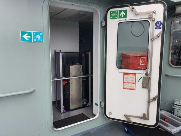
Exail has signed a contract to supply 100 Phins compact inertial navigation systems (INS) to a U.S.-based global defense company for use in unmanned underwater vehicles (UUVs). The Phins Compact INS is designed to provide precise navigation capabilities in challenging environments, remaining functional even when external signals are disrupted. The system’s compact design enables rapid integration into UUVs, allowing for flexible and efficient mission operations in dynamic maritime settings.
According to the company, this contract strengthens Exail’s global leadership in subsea navigation, with its INS technology trusted by more than 50 navies and widely deployed on a broad range of subsea autonomous vehicles worldwide. It also represents a key milestone in the company’s expanding presence in the United States, supporting defense programs with proven, high-performance solutions.
New collaboration to demonstrate how terrestrial 5G-based timing can provide scalable solutions to complement and backup GPS.
NextNav and Oscilloquartz, a division of Adtran, have partnered to demonstrate how 5G-powered terrestrial positioning, navigation, and timing (PNT) technology combined with Oscilloquartz’s established synchronization systems can serve as a scalable complement and backup to GPS. The initiative aims to maintain the operation of critical infrastructure, such as data centers, utilities, and emergency services, during GPS outages by distributing precise, coordinated universal time (UTC) over existing 5G networks for both indoor and outdoor environments.
The collaboration integrates Oscilloquartz’s synchronization technology with NextNav’s terrestrial 5G PNT platforms to introduce an additional timing source, thereby reducing end-user dependence on GPS alone. This effort addresses increasing demand for secure and redundant timing solutions in light of threats to GPS reliability. The companies are aligning their technologies with ongoing Federal Communications Commission initiatives to encourage complementary PNT solutions.
According to the companies, this approach responds to national security and public safety concerns by prioritizing the development of resilient infrastructure. The demonstration of these integrated terrestrial timing capabilities is intended to provide a practical example of how industry can build more robust timing networks and reduce the risks associated with relying solely on GPS.
HawkEye 360 has made powerful enhancements to its GNSS Interference (GNSS-I) Detection product suite. The upgrades — designed with defense, intelligence and national security operations in mind — offer unprecedented accuracy, coverage and insight into global GPS jamming and spoofing threats.
The update includes a new wider frequency algorithm that better distinguishes individual emitters, incorporates GPS spoofing detection, and is terrain adjusted for better geolocation accuracy, delivering greater situational awareness and more precise geolocation of interference sources worldwide.
HawkEye 360’s enhanced GNSS Interference Detection product suite supports strategic decision-making by providing timely, precise insight into potential signal disruptions, enabling stakeholders to better assess risk, respond confidently, and maintain operational continuity in dynamic environments.
With this release, HawkEye 360’s GNSS-I Detection product suite now provides:
15 times increase in geolocation density
Spoofing detection and differentiation
Terrain adjusted for increased accuracy
Consistent monitoring across wide areas of interest
HawkEye 360’s new spoofing detection capability identifies potentially malicious transmitters that imitate legitimate GPS course/acquisition (PRN) codes — a tactic increasingly used to deceive aircraft and mislead navigation systems. The capability supports threat mitigation and trend analysis by detecting and geolocating these spoofers down to a kilometer-level precision.
“In contested environments, timely RF intelligence is the key to mission success,” said Alex Fox, president, International Business Unit. “Traditional land, sea, and air systems struggle in Anti-Access/Area Denial environments, while our satellites provide global GNSS-I detection and geolocation coverage. These enhanced capabilities give defense and intelligence teams the ability to identify and neutralize threats before they disrupt operations, enabling faster decisions and sharper visibility into adversary behavior.”
Government, industry and public safety leaders call for action on PNT resiliency as threats escalate.
GPS is the invisible backbone of modern life, supporting America’s national and economic security in ways both recognized and overlooked. While other countries have developed competing systems, GPS remains far ahead of its rivals. Yet that dominance is also a vulnerability. GPS is a single point of failure, and the U.S. lacks complementary positioning, navigation and timing (PNT) solutions. A successful disruption could cost the U.S. economy $1.6 billion per day and impact everything from first responders to our energy grids.
As threats to GPS reliability mount, policymakers and industry leaders gathered on Capitol Hill to underscore the urgent need for backup systems to protect America’s PNT infrastructure.
Last month, I hosted an event on Capitol Hill called: “The Race to GPS Resiliency: What the US Can Do Today to Strengthen National Security.” It brought together senior officials from the Department of Defense (DOD), the Federal Communications Commission (FCC), Congress and industry to make the case for a layered approach to PNT resiliency. These experts examined the technical vulnerabilities of GPS, the increasing frequency of jamming and spoofing incidents, and the policy measures required to expedite the deployment of complementary technologies.
GPS: Foundational and Fragile
The first panel focused on how federal agencies are addressing growing vulnerabilities in GPS. Thomas Rondeau, Ph.D., principal director for FutureG at DOD, shared some eye-opening insights, including how a DARPA project demonstrated that, for less than $300 in parts from Amazon, one could “create a very bad day for the American military.” He called GPS disruption one of the easiest threats to develop and warned that adversaries are already exploiting this vulnerability as part of modern conflict.
From left to right: Diego Areas Munhoz, reporter, Punchbowl; Thomas Rondeau, Ph.D., principal director for FutureG, DOD; Arpan Sura, senior counsel, chief AI officer, FCC.
Rondeau shared how GPS disruption is now a feature of modern warfare, as he witnessed firsthand during his time at DARPA: “We were seeing massive loss of capabilities, and ordnance, because they were dependent on GPS. And as soon as they flew there, the tent turns on, capability goes away, we lose… assets.”
Arpan Sura, senior counsel and chief AI officer at the FCC, walked through the FCC’s process for evaluating GPS alternatives and discussed how the agency is considering complementary PNT technologies.
“National security is one of his (Chairman Carr’s) top priorities. And we recognize, as Tom mentioned, that GPS remains vulnerable to jamming and spoofing. But also, non-national security threats like solar flares, environmental risks like orbital debris. And there is heavy reliance on it in the U.S. economy,” Mr. Sura said.
Lives on the Line
From left to right: Mariam Sorond, board chair and CEO, NextNav; Adam Eldert, director of public safety for Fairfax County, Virginia.
During the second panel, the conversation shifted from global conflict zones to local communities. Adam Eldert, director of public safety for Fairfax County, Virginia, emphasized the life-saving value of resilient PNT technologies in emergency response.
“Technology should be carrying us forward, allowing us to make better decisions with the information we have to affect life-saving measures faster, get to places quicker and avoid any sort of potential problems,” said Eldert.
Mariam Sorond, CEO and president of NextNav, pointed out that GPS limitations can delay locating 911 callers and responding to active threats like a mass shooting situation she and Eldert had previously discussed. “It’s not just to save somebody’s life, but it’s also about preventing disasters.”
She then highlighted the company’s 5G-powered 3D terrestrial PNT solution, which is currently being considered by the FCC’s ongoing Notice of Inquiry on PNT and in a separate Petition for Rulemaking specific to NextNav. She explained that the company is working to address a national security challenge with a near-term, future-proof solution that delivers a widescale terrestrial PNT solution without relying on taxpayer funding.
Congressional Support
The closing panel featured Rep. Richard Hudson (R-NC), Chairman of the House Energy & Commerce Subcommittee on Communications and Technology, and former Rep. Greg Walden (R-OR), who previously chaired the full committee.
Both Hudson and Walden warned that the United States is lagging behind adversaries such as China and Russia in deploying terrestrial backup systems to GPS.
Chairman Hudson reflected on how the issue hits close to home: “I represent Fort Bragg, the largest army base in the world. We call it the epicenter of the universe. Our special forces and airborne troops that deploy out of Fort Bragg rely on GPS for almost everything they do. So, real-life scenarios with them keep me awake at night.”
Chairman Walden spoke about another high-profile case in San Diego. “[T]here was a naval exercise between two ships, and they jammed GPS… which caused some issues, ” said Walden. “It also speaks to the problem we have, in America, where, unlike China and Russia, two of our adversaries, they have terrestrial-based systems for GPS backup.”
What Comes Next
The event made clear that action is needed — and possible. Mr. Sura told the crowd that he believes the FCC’s Notice of Inquiry will help drive a conversation about a holistic approach to PNT resiliency, exploring the economics of how these systems will work, and how to foster competition in a way that will yield multiple outcomes. When asked about next steps, Mr. Sura encouraged the group to “stay tuned.”
Speakers throughout the event called for continued public-private collaboration to accelerate development of a more resilient PNT system — one that combines space-based and terrestrial technologies to safeguard national security, critical infrastructure, and public safety.
Congressman Hudson closed with a note of urgency and optimism: “It’s clear the FCC understands the urgency, and they’re conducting thorough reviews right now.”
Diane Rinaldo of Peake Advisors, which sponsored the event, is one of the country’s leading authorities on 5G, telecommunications supply chain security and privacy. She served as Acting Administrator of the National Telecommunications and Information Administration and Acting Assistant Secretary of Commerce for Communications and Information in the first Trump Administration.
L3Harris has demonstrated a positioning, navigation and timing (PNT) solution for the U.S. Space Force’s Space Systems Command that is adaptable across platforms, fully reprogrammable on orbit and scalable to support more signals and increased power as PNT threats evolve. According to L3Harris, the solution is designed to provide the Space Force with the flexibility to deploy smaller, multi-launch-capable satellites, thereby strengthening or diversifying its satellite constellation.
During a two-day design concept review, L3Harris presented a resilient-GPS (R-GPS) prototype that exceeded current requirements, highlighting its potential to accelerate the Space Force’s roadmap for a stronger, more adaptable PNT infrastructure. Using the Navigation Technology Satellite-3 reprogrammable payload and NSA-certified cryptography, the company simulated the operation of an R-GPS satellite transmitting navigation signals. These signals were successfully acquired and tracked by monitoring stations, military receivers and commercial equipment, demonstrating that R-GPS technology can be seamlessly integrated into the existing GPS framework.
“Our team transmitted, tested and validated a core set of R-GPS signals across the entire enterprise to demonstrate a fully reprogrammable, resilient PNT solution for the Department of Defense,” said Ed Zoiss, president of Space and Airborne Systems at L3Harris. “We leveraged best-in-class commercial technology and the government’s investment in NTS-3 PNT technologies.”
L3Harris followed a “prototyping with purpose” approach that showcased maturity far beyond a traditional Preliminary Design Review, resulting in a low-risk, achievable plan for the future development phases of the R-GPS program. The L3Harris R-GPS design includes capabilities aligned to future Lite Evolving Augmented Proliferation, providing an opportunity for roadmap acceleration and reduction in lifecycle costs.
“Our approach supports satellite design verification, proves compatibility with the Control Segment and user equipment, and enables early integration opportunities,” Zoiss said. “After more than five decades in the field, we understand the challenges in aligning the Space, Control and User segments of the GPS enterprise, so we used a holistic, unified approach.”
The Design Concept Review demonstrated how the L3Harris R-GPS satellite can minimize impact on existing control systems while maintaining backward compatibility with current and future user equipment. In 2024, L3Harris was selected to design concepts for Phase 0 of the R-GPS program through the Space Enterprise Consortium, which the National Security Technology Accelerator manages. The agile R-GPS satellite program aims to reduce costs by launching eight smaller, more advanced space vehicles simultaneously, allowing the United States to quickly modernize GPS.
Honeywell has been selected by the U.S. Department of Defense’s (DOD) Defense Innovation Unit (DIU) to participate in the Transition of Quantum Sensing (TQS) program. The program aims to accelerate adoption of quantum sensors to address near-term alternative position, navigation and timing (PNT) and intelligence, surveillance and reconnaissance (ISR) applications for the U.S. Joint Forces Command.
Honeywell has been chosen to support the TQS program under two DOD contracts: CRUISE (Compact Rubidium Unit for Inertial Sensing and Estimation) and QUEST (Quantum Enabled Sensor Technologies for MagNav).
“With the growing threat of jamming and spoofing, aircraft and naval vessels on critical missions can no longer rely solely on GPS,” said Matt Picchetti, vice president and general manager, Navigation and Sensors, Honeywell Aerospace Technologies. “Quantum sensors have the potential to augment existing navigation solutions, helping pilots operate with greater confidence. Honeywell’s pedigree in fielded sensors and navigation solutions provide us with a unique perspective to ensure the technology is viable beyond the laboratory.”
The CRUISE program, established by the DOD in partnership with Vector Atomic, will focus on developing quantum sensor-based inertial measurement units (IMUs) to provide a standalone navigation solution without relying on traditional GNSS susceptible to jamming and spoofing. Honeywell will support the development of this quantum-sensor-based technology, which will enable the measurement of acceleration and orientation from an IMU mounted to a vehicle to calculate changes in position and velocity. As a result, it will meet next-generation performance requirements at a lower size, weight and power than existing products.
The QUEST program aims to advance the performance of magnetic anomaly aided navigation (MagNav), which is a GNSS-independent navigation technique that uses quantum magnetometers to leverage measurements of the magnetic field of the Earth as a navigation signal. Through the program, the DOD aims to improve these quantum magnetometers and demonstrate their utility in GNSS-denied flight. Building on its deep expertise in innovative navigation solutions, Honeywell’s main contribution will be to generate novel algorithms that utilize these sensors and improve navigation accuracy.
“As quantum sensor-based navigation technology matures, we believe it not only has the potential to displace existing technologies but will also be a serious disruptor to the inertial and magnetic sensor industries,” Picchetti said. “Most importantly, it could improve navigation in high-stakes environments – enhancing safety, efficiency and overall mission success for the DOD.”
Q-CTRL has completed a major field trial with Australian Defence on board the Royal Australian Navy’s Multi-role Aviation Training Vessel (MATV), the MV Sycamore. The results of the trial demonstrated advancements in software-ruggedized quantum sensing for navigation.
In the trials, Q-CTRL field deployed a quantum dual gravimeter, which measures tiny variations in Earth’s gravity as part of a next-generation quantum-assured positioning, navigation, and timing (PNT) system operable when GPS is unavailable or untrusted.
This first trial saw over 144 hours of continuous operation and successful data collection with no human intervention during real maritime operations.
“Quantum sensors provide a near-term opportunity to achieve transformational defense capabilities, but previous deployments in the field have struggled to deliver defense-relevant performance,” said Q-CTRL CEO and founder Michael J. Biercuk. “Operating on a real moving vehicle is just not the same as conducting a science experiment; at Q-CTRL, we’ve taken a different approach to getting quantum sensors out of the lab, focusing on software as the critical enabler of performance in the real world.”
Earlier this year, Q-CTRL announced successful airborne field trials of a new generation of quantum-magnetic navigation solutions, Ironstone Opal, validated for the first time to outperform comparable conventional alternatives in challenging real-world settings by 50 times.
Developed and fielded in 14 months, the dual gravimeter was installed in a “strapdown” configuration (bolted to the floor) in the space of a single server rack in a communications room onboard MV Sycamore. The sensor consumed only 180W of power – about 10 times less than a household toaster.(Photo: Q-CTRL)
The newly announced trials of Q-CTRL’s gravimetric navigation technology open opportunities to bring quantum-assured navigation to maritime vessels where magnetic navigation can be less effective.
GPS denial has become one of the most pressing strategic challenges in both defense and commercial settings, risking major disruptions to civilian and military operations. Quantum navigation promises a robust and reliable GPS backup that cannot be jammed or spoofed.
Q-CTRL’s navigation capability is urgently needed in contested maritime environments, as instances of spoofed signals caused significant disruptions to ships in the Middle East waterways as recently as June 23. This causes not only critical logistical issues but disrupts collision avoidance efforts, revealing major safety implications.
In quantum gravimetric navigation, the quantum gravimeter continuously “sees” the otherwise invisible hills and valleys in Earth’s gravity, allowing a navigation computer to compare its observations against known gravity maps. This is similar to orienteering, where one can position oneself on a map by identifying landmarks like valleys, mountains, rivers, or roads. GPS is not needed, making it a robust backup in contested regions.
Q-CTRL’s demonstration with the Royal Australian Navy departs from most previous quantum sensing field trials in that these tests mandated peak performance with full autonomy and without the addition of any special infrastructure. The sensor had to operate as a real navigation system would operate during a defense mission.
The ship’s motion and engine vibrations were sufficient to cause total loss of signal using conventional operating techniques typically employed in research experiments. To address these losses, Q-CTRL’s software-ruggedization strategies recovered operation even while MV Sycamore was underway.
Quantum sensing leverages the physics of light and matter on the smallest scales to enable the detection of tiny signals. Because these devices work based on the fundamental laws of physics and are not affected by drift like other GPS alternatives, their outputs do not change over time, enabling new opportunities where long-term stability is essential. Generally, however, these devices are significantly degraded when taken from a research laboratory into the real world, an issue addressed by Q-CTRL’s software-ruggedization technology.
For more on Q-CTRL’s software-ruggedized quantum sensing technology, read their peer-reviewed technical demonstration published in Nature.
As GNSS denial, jamming and spoofing threaten aviation safety, SandboxAQ and Acubed, the Silicon Valley innovation center for Airbus, have released real-world test results from a five-month, nationwide projectdesigned to test the accuracy of AQNav.
AQNav is an artificial intelligence-driven magnetic navigation (MagNav) system. AQNav uses advanced quantum magnometers to read Earth’s crustal magnetic anomalies, like a geoohysical fingerprint, then employs large quantitative models (LQMs) to filter out electromagnetic interference and precisely determine an aircraft’s position without relying on satellite signals.
These new results come from a nationwide initiative with Acubed’s Flight Lab to test the navigational accuracy of AQNav. Meeting the aviation industry’s Required Navigation Performance (RNP) standards is necessary for deploying the system on military, commercial and civilian aircraft.
AQNav’s performance was tested under various opertional scenarios and demonstrated advanced precision, accoding to SandboxAQ. The goal was to determine whether magnetic anomaly-aided navigation could broadly meet navigation requirements for commercial aircraft. AQNav’s capabilities exceeded the accuracy required for en route travel between airports — even on the program’s longest flight.
Accuracy
RNP Standard
Required Accuracy (meters)
% of Flight Time Met
RNP 0.3
550
64%
RNP 1
1,852
95%
RNP 2
3,704
100%
To demonstrate how the real-time capable system would operate in real-world conditions, flight data was collected, reprocessed, and streamed in real time to produce statistical insights, offering representative capability data for joint team evaluation.
Real-World Impact
SandboxAQ and Acubed focused on designing tests to mirror authentic, real-world aviation scenarios. For example:
Standard aircraft platform: AQNav was tested using publicly available magnetic maps aboard a standard Beechcraft Baron 58 – rather than a compensated geosurvey platform. This aircraft was modified only to accommodate the additional AQNav instrumentation – no extensive electromagnetic shielding or specialized noise isolation were used. All sensors were positioned inside the aircraft, powered by AQNav’s software to deliver a clean magnetic signal.
Use of apublicly available map. For all flights, AQNav researchers used the publicly available North American Magnetic Anomaly Map (NAMAM), which covers the U.S., Canada, parts of Mexico and surrounding oceanic regions.
Unfiltered flight paths: Flight operations spanned diverse, operationally relevant routes between 200 airports across the entire continental U.S. (Fig. 1), without filtering based on magnetic anomaly strength, magnetic map quality, or favorable geomagnetic gradients. More than 150 hours of flight data was collected.
Diverse geophysical environments: Data was collected over a full range of conditions, from magnetically-rich mountains to sparsely featured plains, reflecting real-world geographies where aircraft might operate without GNSS.
True operational noise: Onboard, AQNav successfully filtered out the real-world interference generated by the aircraft, including electromagnetic, vibrational and other airframe-induced noise.
Fig. 1: Acubed Flights with AQNav (Credit: AQNav
Elijha Williams, AQNav’s technical engagement manager, said: “Our campaign was not about demonstrating proof of concept performance under ideal conditions, it was about proving AQNav’s viability under the noisy, messy, and unpredictable environments real pilots face every day.”
During test flights exceeding two hours, AQNav outperformed the Inertial Navigation System (INS) without GNSS 100% of the time. During a one-hour flight over the challenging mountainous and forested terrain of California, AQNav achieved its best-observed accuracy of less than 74 meters, or roughly two-thirds the length of an American football field.
Precision, Scale and Autonomy for the Future
This campaign marks a significant step toward widespread adoption of AQNav in aviation. By consistently maintaining accuracy in an uncontrolled, national testbed, SandboxAQ demonstrated AQNav’s operational robustness under real-world conditions.
Andrew Sosa Sosanya, a quantum navigation machine learning engineer at SandboxAQ, highlighted the impact of the data collected: “Thanks to Acubed, the U.S. Air Force, and other partners, we’ve accumulated a highly relevant MagNav dataset. This creates a flywheel effect—the more data we gather, the faster we can improve model accuracy across diverse mission profiles.”
AQNav is also undergoing testing with Boeing, a U.S.-allied air force, and as part of NATO’s 2025 DIANA cohort.
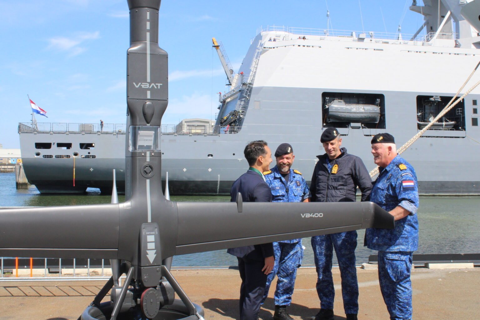
The Netherlands Ministry of Defence has procured eight V-BAT unmanned aircraft systems from Shield AI to enhance maritime intelligence, surveillance and reconnaissance (ISR) operations for the Royal Netherlands Navy and Marine Corps.
The deal was publicly announced at the “Maritime Uncrewed” event hosted by the Royal Netherlands Navy in Den Helder, where officials highlighted the V-BAT acquisition as part of a broader effort to modernize the force.
The navy’s decision was informed in part by V-BAT’s demonstrated success in Ukraine, where the platform is executing long-range, long-endurance ISR and targeting with independence from GNSS.
According to Shield AI, the decision to procure V-BAT reflects a push to field battle-proven, autonomy-enabled systems capable of operating in contested environments and without reliance on GNSS for navigation or mission execution.
The navy’s decision was informed in part by V-BAT’s demonstrated success in Ukraine, where the platform is executing long-range, long-endurance ISR and targeting with independence from GNSS. V-BAT also conducted a successful month-long flight trial during NATO’s REPMUS 2024 exercise, where V-BAT conducted maritime ISR operations aboard the HNLMS Johan de Witt. That event helped validate the system’s shipboard performance and informed the Dutch Ministry’s decision-making process.
The V-BAT is a single-engine ducted-fan vertical takeoff and landing (VTOL) unmanned aircraft system operationally deployed across multiple regions worldwide. Its compact footprint and ability to launch and recover in confined spaces make it suitable for shipborne and austere environments, ensuring flexibility and resilience in complex missions.
V-BAT has operated in GPS-denied and comms-contested environments. Its proven performance in regions like Ukraine, the Black Sea, and the Indo-Pacific demonstrates its ability to withstand advanced electronic warfare threats that have grounded many traditional drones.
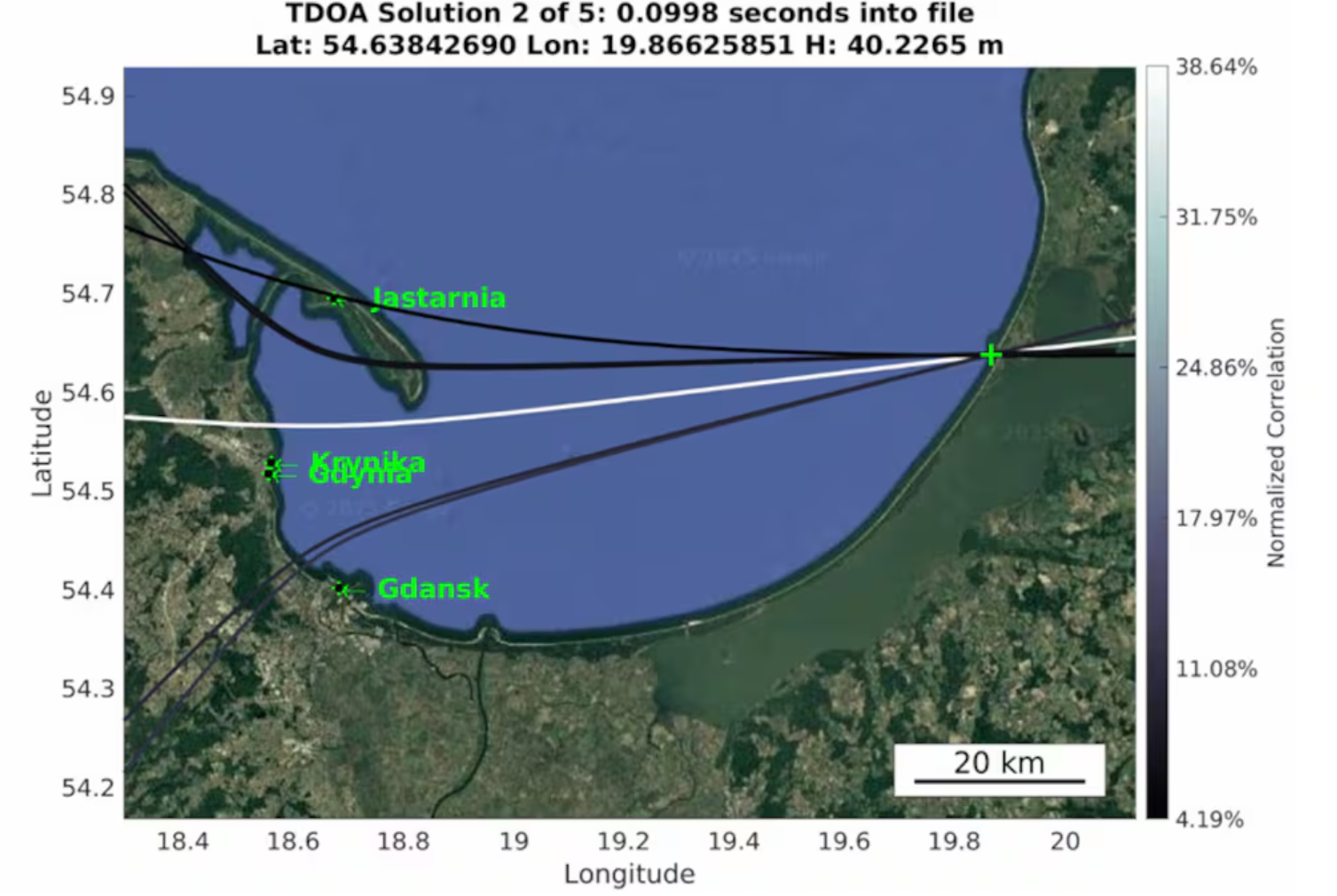
Radio waves emanating from secretive facilities run by Russia’s military are the culprit behind GNSS jamming in the Baltic Sea, according to Defense News.
The news outlet reports that Polish researchers collected jamming and spoofing information on incidents covering the Gdansk airport, shipping lanes, and the airspaces of Estonia and Finland. The interference has been recorded almost daily since Russia’s full-scale invasion of Ukraine in February 2022, resulting in flight cancellations, airport closures and commercial ships steering off track.
In March, eight European countries, including the Baltic states, Finland, Poland, France, the Netherlands and Ukraine, lodged a complaint with the UN about the practice. Several UN agencies have also taken up the issue, including the International Maritime Organization, the civil aviation authority ICAO and the International Telecommunications Union.
Russia, itself a Baltic Sea country, has not responded to the charges of interference. Likely origin spots include Kaliningrad, which is between Poland and Lithuania, and the St. Petersburg area. Both regions are known to have a heavy Russian military presence, including divisions specialized in electronic warfare.
“Seen & Heard” is a monthly feature of GPS World magazine, traveling the world to capture interesting and unusual news stories involving the GNSS/PNT industry.
West Point Cadets Map Electronic Warfare West Point cadets conducted a senior thesis project investigating the use of GNSS technology to map and visualize electronic warfare activities in the South Pacific, specifically focusing on GNSS spoofing. Their research, centered on the Huangpu River and Northeastern Shanghai, aimed to identify patterns of malicious GNSS interference and potential perpetrators, highlighting the strategic and economic motivations behind these actions in the region. By developing data visualizations of spoofing incidents, the cadets created a model that could be scaled up to analyze larger areas.
Credit: Eric S. Bartelt / USMA PAO-VI
South Africa Rising Above Water Researchers from the University of Bonn have found that South Africa’s land is rising by up to 2 mm per year, not because of deep mantle activity, but due to water loss from severe droughts. This uplift was detected using the TrigNet network of GNSS stations, which precisely measures changes in land elevation. As groundwater is depleted, the Earth’s crust rebounds upward — a process GNSS stations can monitor in real time.
Credit: THEGIFT777 / E+ / Getty Images
Türkiye to Launch Homegrown Satellite Navigation and Mapping System Türkiye is developing the Regional Positioning and Timing System (BKZS) to launch its own GPS and mapping application, in an effort to reduce dependence on foreign technology and enhance cybersecurity amid growing industrial automation. The system will provide precise location, navigation and timing data via Turkish satellites as an alternative to global systems including GPS, supporting critical sectors such as military operations, civilian communications, smart transportation, and precision agriculture.
Quantum Navigation System Serves as GPS Backup Q-CTRL, a quantum infrastructure software company based in Sydney, Australia, has demonstrated a new quantum navigation system, Ironstone Opal, as a backup to GPS technology. The Ironstone Opal system uses quantum sensors to detect variations in the Earth’s magnetic field, determining precise geographic coordinates with the help of artificial intelligence-based software. Ironstone Opal is passive and does not emit signals, making it resistant to detection and jamming. Field trials showed the system outperformed a high-end inertial navigation system and served as a reliable GPS backup by up to 50 times in ground vehicles and 11 times in aircraft.
News outlet MSN has published a slideshow detailing seven take-aways from recent GNSS spoofing defense moves against Iranian missiles headed toward Israel. The missiles instead ended up in the Mediterranean Sea, apparently because of successful electronic hacking.
“The incident has caused tremors within the defense and cyber-defense communities, pointing to the mounting sophistication of electronic warfare and the weakness inherent in contemporary navigation systems,” the report states.
The event is being studied as a sophisticated method that “deceived” the missile’s guidance, making it continue on a reasonable course while deviating it from its targeted direction, an advance in electronic warfare that requires knowledge of the missile’s flight algorithms.
“Spoofing detection is much more difficult than jamming, since spoofed signals are made to mimic legitimate signals. Sophisticated detection techniques, like those employing pseudorange difference and sum sequence linearity, are being researched to separate genuine from spoofed GNSS signals. These detection techniques examine the consistency and conduct of signal measures, searching for minute discrepancies that indicate spoofing efforts.”
Spoofing is also affecting civilian sectors, such as when cargo ships collided in the Strait of Hormuz. The International Air Transport Association and the European Union Aviation Safety Agency have published a comprehensive plan to mitigate risks stemming from GNSS interference. The plan was part of the conclusions from a jointly hosted workshop on the topic of GNSS interference.
Agencies also are seeking reliable countermeasures as well as complementary PNT such as magnetic navigation.