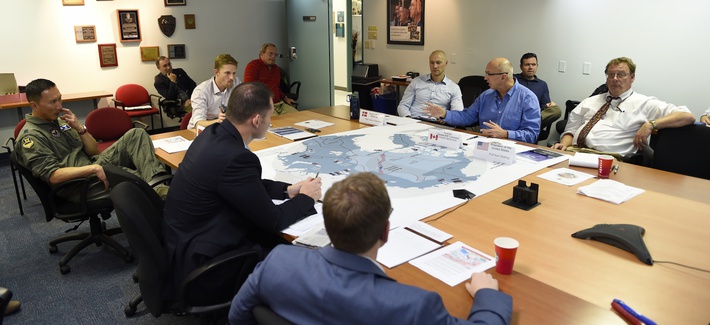
The Air Force Space Command will conduct the 12th Schriever Wargame Oct. 11 at the Maxwell Air Force Base in Alabama.
The Schriever Wargame scenario, set in the year 2028, will explore critical space issues and investigate the integration activities of multiple agencies associated with space systems and services. Schriever Wargame 2018 (SW 18) will include international partners from Australia, Canada, France, Germany, Japan, New Zealand and the United Kingdom.
The objectives of the wargame are centered on:
examining how international partner capabilities can deter an adversary from extending or escalating a conflict into space;
gaining insight into resiliency, deterrence, and warfighting through international partner synchronization of space and cyberspace operations;
exploring various combined command and control (C2) frameworks to employ and defend air, space and cyberspace capabilities in support of global and geographic/regional operations;
identifying the strategic and operational contributions of space and cyberspace in a multi-domain conflict; and
exploring partnerships framed by a whole of governments approach (international, civil, commercial) to combined space and cyberspace operations.
The SW 18 scenario depicts a notional peer space and cyberspace competitor seeking to achieve strategic goals by exploiting those domains. It will include a global scenario with the focus of effort towards the U.S. Indo-Pacific Command (USINDOPACOM) Area of Responsibility.
A 2016 wargame involving the Air Force and Navy at the Naval Postgraduate School. (Photo: U.S. Navy)
The scenario will also include a full spectrum of threats across diverse operating environments to challenge civilian and military leaders, planners and space system operators, as well as the capabilities they employ.
The Schriever Wargame Team will conduct the wargame on behalf of Air Force Space Command, headquartered in Colorado Springs, Colorado. Approximately 350 military and civilian experts from more than 27 commands and agencies around the country, as well as seven international partners, will participate in the wargame.
U.S. commands and agencies participating in Schriever Wargame 2018 include:
The U.S. Army is drafting new rules for the use of GPS receivers in weapon systems to combat spoofing and jamming attacks, as well as signal loss in GPS-denied environments, according to news reports.
The six- to seven-page capabilities requirements document is awaiting a signature from Army leadership, according to Willie Nelson, director of the assured PNT (positioning, navigation and timing) cross-functional team. Nelson spoke to reporters Oct. 9 at the Association of the U.S. Army annual meeting in Washington, D.C.
The Army has been trying for years to complete a GPS requirements document, a “system of systems architecture for assured PNT.” But with virtually every device equipped with GPS, the document would have been too big and too broad, Nelson said.
(Photo: U.S. Army)
The approach now is for separate sets of requirements: one for mounted equipment (now complete and awaiting the signature), a dismounted requirement, and situational awareness.
The difficulty facing the Army is the plethora of PNT systems in use. For instance, an armored personnel carrier may have five to seven unconnected GPS receivers, some with encryption, some without. The weakest receiver could negatively affect the vehicle, Nelson said.
With the new requirements, Army vehicles will have a consolidated, networked, software-based PNT solution. Dismounted receivers used by soldiers will have similar requirements.
Industry will be asked for specific solutions within each of the PNT sectors rather than an “all of the above” solution.
The Army is also expected to create a training program for soldiers that operate PNT systems.
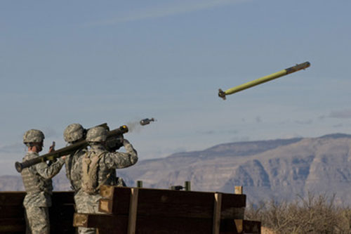
U.S. Army completes qualification testing for new Stinger missile proximity fuze.
The new proximity fuze enables the Stinger missile to destroy a wider array of battlefield threats such as enemy unmanned aircraft systems. (Photo: U.S. Army)
The U.S. Army has completed qualification testing for a new proximity fuze that significantly enhances the combat-proven Stinger missile produced by Raytheon Company.
The proximity fuze detonates the warhead if the missile passes within a certain radius of the target, creating a cloud of shrapnel that eliminates the target.
During testing at Eglin Air Force Base in Florida in April 2017, the upgraded weapon system scored a perfect 100 percent hit rate against a variety of targets. The missiles were shoulder- and vehicle-launched.
The new proximity fuze enables the lightweight, self-contained air defense system to destroy a wider array of battlefield threats such as enemy unmanned aircraft systems by detonating the missile’s warhead near the target, while maintaining its hit-to-kill capability.
“Equipped with a new proximity fuze, Stinger is an affordable, near-term and proven solution for countering emerging threats in the battlespace,” said Kim Ernzen, Raytheon Land Warfare Systems vice president. “Together with the Army, we are putting the most capable Stinger yet into the hands of our brave men and women on the battlefield.”
https://youtu.be/h75hxN-hcMQ
With qualification testing complete, the Army can move toward a near-term fielding under an Urgent Materiel Release. Plans call for the new proximity fuze to be integrated into Stinger missiles as part of a Service Life Extension Program to be conducted at the Army’s ammunition plant in McAlester, Oklahoma.
Combat proven, the Stinger missile has more than 270 fixed- and rotary-wing intercepts to its credit. It’s deployed in more than 18 nations and with all four U.S. military services. The weapon can be rapidly deployed by ground troops and on military platforms, and has been integrated for use on the Apache Attack Helicopter.
An Air Force professor was honored for years of work exploring every PNT technology imaginable in conjunction with GPS; Rockwell Collins launched a new MicroSTRIKE multi-GNSS chip for military and professional applications, available globally on a non-ITAR basis; and Spirent Federal previewed its SimMNSA, a new M-code simulation option delivering to authorized customers by the end of the year.
John Raquet, AFIT, accepts 2018 Leadership Award for Services from Justin Eldredge, Spirent Federal. (Photo: Melanie Beus)
John Raquet, a professor in the Department of Electrical and Computer Engineering at the Air Force Institute of Technology, received the 2018 Leadership Award for Services. Raquet was recognized for work he and his team at the Autonomy & Navigation Technology (ANT) Center developed on PNT sensors and systems utilizing almost every available source, including GPS, GNSS, inertial, vision, lidar, magnetic field, pseudolites, radar, terrain mapping, signals of opportunity, star trackers, radio ranging, 3D audio, X-ray pulsars, clocks, and more.
Raquet has co-authored many defense-oriented technical papers over the past three decades. See the list at the end of this article for some of the most recent ones.
Justin Eldredge from Spirent Federal introduced Raquet and bestowed the award, after updating the audience on Spirent’s most recent advance: “This year we maintain our position of being first to market with new signals, with the launch of SimMNSA. We’re currently in the final test phase of this new M-code option and it will delivering to several authorized customers by the end of the year. If M-code signals aren’t in the spectrum of testing for you, we offer products that simulate all other GNSS signals, plus a variety of other sensors.”
SimMNSA was demo’d at the Spirent Federal Systems booth at the neighboring ION GNSS+ conference. A video presentation of SimMNSA (for Modernized Navstar Security Algorithm) is available here. Spirent’s new software will support M-code using MNSA. M-code is an updated GPS military signal that is being rolled out as part of the modernization of the current GPS constellation. Until now, AES and SDS have been the only methods authorized to be used within a GNSS simulator to produce M-code. As the long-awaited MNSA M-code signals become available, Spirent Federal Systems will make this capability available to authorized users on the GSS9000 series simulator.
ANT
After receiving the 2018 Leadership Award, Raquet spoke about his work at theAutonomy & Navigation Technology Center. “Sometimes I called the ANT the Crazy Idea Factory. We’ve tried lots and lots of things. I think I have the best job in the world, because I get to experiment with many, many things, and work with amazing people.”
John Raquet, U.S. Air Force Institute of Technology (Photo: Melanie Beus)
“This is not the kind of community where you build something once and you’re done, you put it away. This is a growing worldwide enterprise that takes new talent to come in and fill the spots that many of the people in this room have occupied. I’m privileged to see some of the students that we’ve worked with to then go on and fill some of the gaps, really do some amazing things.”
MicroSTRIKE, a non-ITAR GPS chip
Two awards prior to Raquet’s Services award, Phil Froom from Rockwell Collins, UK, spoke about an innovative venture from Rockwell and partners QinetiQ UK as he bestowed the Satellites award.
“For many years most of you here this evening will have known Rockwell Collins as a reliable partner in the delivery of Secure (encrypted) GPS receiver, and indeed, we are still the largest producer of encrypted military GPS solutions in the world. Our partners QinetiQ also have great expertise in the design and delivery of high assurance low SWAP GPS receivers, bringing together many years of expertise of our two companies in this new venture.
Phil Froom, business development lead for Rockwell Collins, Europe, Middle East and Asia (Photo: Melanie Beus)
“However, over the past few years we have seen our military and professional (government) users looking to greater flexibility in their use of GNSS, as new capabilities and constellations come on line. But with that flexibility, a retention of assurance and where possible, mitigation of threats. For this reason, last May, Rockwell Collins and QinetiQ signed an Alliance Agreement in London, to produce a new family of high-assurance, multi-constellation GNSS receivers for professional and military use.
“This new family of receivers is aimed to be complementary to the current encrypted family of Rockwell Collins receivers in service across the globe, but allow the customer to select his level of capability and protection based upon his operational, political or even financial needs. The new “MICRO” family of GNSS receivers will offer a multi-constellation open service (MCOS) GNSS capability, which will initially provide two receivers; the first, to be known as the Q40-MicroPNT, will address dismounted low dynamics requirements, and the second, the Q40-MicroSTRIKE, will be a gun hard, high dynamics receiver.
“You will note I said they are MCOS receivers. Therefore, they will not include an encryption device, will be Non-ITAR and will actually be produced in Europe, under the control of Rockwell Collins UK. QinetiQ are today working on the Q40 ASIC and, once available, this will be incorporated into these first two Micro Family receivers.
“These receivers will be of a common format to our existing and highly successful SAASM based MicroGRAM receivers and will offer users and OEMs the ability to select an MCOS receiver, or a SAASM (or ultimately M-Code) receiver, of a common form – factor, to meet their mission or platform needs. Thus allowing OEMs to reduce costs in integrating different form-factors, and to allow users to hold common hardware, but mounting mission specific receivers.
“We are of course extremely excited about this Alliance with QinetiQ and equally by the prospect of what it will bring to our existing and future users as we all move forward into this new era of GNSS capability.”
Check out videos from the event below. Click on the icon in the top left hand corner to choose which video you’d like to watch.
Recent technical papers co-authored by John Raquet.
• “Magnetic field navigation in an indoor environment,” Ubiquitous Positioning Indoor Navigation and Location Based Service, (Aiding an inertial navigation system when GNSS signals are not available, by taking advantage of the uniqueness of magnetic field variations);
• “Comparison of two image and inertial sensor fusion techniques for navigation in unmapped environments,” IEEE Transactions on Aerospace and Electronic Systems, (navigation of miniature aerial vehicles (MAVs) couplimng information from an IMU with visual information from an electro-optical camera);
• “Real-time UWB-OFDM radar-based navigation in unknown terrain,” IEEE Transactions on Aerospace and Electronic Systems (a signal processing algorithm and simulation study for aerial navigation with an ultrawideband orthogonal frequency division multiplexed (UWB-OFDM) radar in GPS-denied environments;
• “Navigation in GPS denied environments: Feature-aided inertial systems,” Air Force Research Lab, Eglin AFB FL Munitions Directorate (latest alt-nav trends for navigating in difficult urban, indoor, and underground environments where typical GPS receivers do not function;
• “Coded aperture aided navigation and geolocation systems,” US Patent office #8577539 (A micro air vehicle having a navigation system with a single camera to determine position and attitude of the vehicle using changes the direction to the observed features);
• “Multisensor navigation systems: A remedy for GNSS vulnerabilities?” Proceedings of the IEEE (A multisensor navigation approach to GNSS-challenged environments using inertial measurement units (IMUs), barometers, magnetometers, odometers, and digital compasses);
• “Large scale image aided navigation,” IEEE Transactions on Aerospace and Electronic Systems (images from an airborne camera match features against a reference image to compute global position);
• and many more.
Orolia has introduced its latest military technology innovation, the SecureFind Combat Rescue Beacon, at the 2018 AUSA Annual Meeting in Washington, D.C.
In addition to protecting the most critical assets and leaving no one behind, combat search and rescue (CSAR) technology can significantly enhance military operations by avoiding the loss of sensitive information and technology, avoiding hostage situations and helping to prevent conflict escalation.
SecureFind is based on Orolia’s search-and-rescue technology suite, selected by military forces for CSAR missions. The wearable base unit includes an open channel search-and-rescue solution, for military use in training or test mode. It can also be configured with a customer-defined, secure channel solution for covert operations.
The versatile CSAR solution operates with a silent, push-button functionality that does not require voice activation. SecureFind enables military forces to precisely and safely execute CSAR missions, with optional Assured PNT (positioning, navigation and timing) technology that prevents GPS signal interference, spoofing and jamming, the company said.
“There is no greater need for urgency, stealth and precision than when military personnel are isolated in rugged environments or behind enemy lines,” said Paul Zweers, Orolia’s vice president of defense programs.
“Software-defined, wearable communications technology is now more important than ever on today’s air, land, sea and cyber battlefields,” added Orolia CEO Jean-Yves Courtois. “CSAR missions are just the beginning of potential uses for this resilient military technology, which can ensure reliable positioning, navigation and timing data in any operating environment. Orolia’s solutions are tailored to support today’s soldiers and engineered with a view toward the future of global military networks.”
According to Orolia, the standard SecureFind solution is available at a price point that could enable thousands of warfighters to benefit from the new battlefield technology. More advanced functionality is also available, such as the ability to change signals on-the-go for additional security, to detect and mitigate GPS jamming and spoofing, and to generate important strategic information such as virtual battlefield maps of jamming and spoofing activity.
Orolia offers a cost-effective, modular approach to assured PNT, with a flexible, open architecture that integrates easily with legacy systems. This layered platform meets critical technology requirements without over-engineering a solution that is complex, expensive and difficult to maintain.
Additional SecureFind product information is available at the AUSA Annual Meeting, Orolia booth #8051.
Honeywell has signed an agreement with the Greek Ministry of Maritime Affairs and Insular Policy to upgrade Greece’s search-and-rescue operations using next-generation, satellite-based tracking technology.
Under the agreement, Honeywell will provide the Hellenic Center of Mission Control with eight satellite antennas, three rescue control systems and computer equipment, as well as installation, customization, training and technical support services for seven years.
Using satellite signals, Honeywell’s technology can precisely locate emergency distress beacons and coordinate the deployment of rapid response teams, the company said.
The technology incorporates the COSPAS-SARSAT system, an international satellite-based program for distress alert detection and information distribution.
“By leveraging a network of ground-based antennas and medium earth orbit satellites, we can more precisely locate distress signals from emergency beacons,” said Mehrez Hached, director of business development for Honeywell’s Global Tracking and Search and Rescue business. “This Honeywell solution will help the Greek National Search and Rescue Coordination Center and the Hellenic Coast Guard save lives by quickly identifying aircraft, ships and people in distress regardless of how remote their location.”
Honeywell will install the satellite antennas on sites operated by the Hellenic Air Force and deploy management and surveillance equipment to the Hellenic Coast Guard Headquarters in Piraeus, Greece.
Honeywell’s search and rescue solutions are part of the company’s Safety and Productivity Solutions business. Honeywell provides fixed antennas, terminals, consoles and software applications to quickly locate missing assets on land or at sea and minimize emergency response times.
The company’s software offerings include SARMaster Search, a full-featured incident management application used by frontline operators to coordinate rescue operations, which has helped save tens of thousands of lives.
Honeywell’s tracking technology was incorporated into the European Space Agency’s Galileo search-and-rescue program, a pan-European program designed to dramatically reduce emergency response times using geo-positioning satellites.
Ravenswood Solutions has been awarded a $1.3 million contract to support the U.S. Army Joint Modernization Command (JMC) during an exercise this fall at Fort Bliss, Texas, and White Sands Missile Range, New Mexico.
Ravenswood will provide support via its GPS-based Mobile Ground Truth System (MGTS) — also known as FlexTrain. The rapidly deployable system tracks individual vehicles, units and participants during exercises. Using the system, unit leaders can monitor events in real time and replay scenarios.
The results are real-time casualty assessments, a record of factors affecting capabilities and operations.
Ravenswood has trained more than 130,000 troops with FlexTrain. The MGTS has been successfully deployed in 60 x 80 kilometers areas and can track thousands of players, the company said.
DT Research has launched the DT372AP-TR rugged real-time kinematic (RTK) tablet, a lightweight military-grade tablet that offers RTK to enhance the precision of position data derived from satellite-based positioning systems.
The tablet enables 3D point cloud creation with centimeter-level accuracy to meet the high standards required for scientific-grade evidence in court, the company said.
The DT372AP-TR RTK tablet is military-grade with an IP65 rating, yet lightweight — offering the versatility to be used in the field, office and vehicles.
A dual-frequency GNSS module is built into the tablet, which uses real-time reference points within 1- to 2-centimeter accuracy to position 3D point clouds created from aerial photogrammetry, using GPS, GLONASS and Galileo satellites. Users can measure with the RTK GNSS positioning directly using an external antenna for better survey-grade precision.
“We designed a more compact tablet that still offers all the functionality of a rugged RTK tablet, to give ultra-mobility to law enforcement and first responders who are already weighed down with heavy equipment,” said Daw Tsai Sc.D., president of DT Research. “With programmable side buttons and directional pad, this tablet combines ease of use with a small form factor and centimeter level accuracy, there is nothing in the market now in the same category that can offer this combination.”
The DT372AP-TR RTK tablet is compatible with existing survey and GIS software for mapping applications and brings together an advanced workflow for data capture, accurate positioning and data transmitting.
The tablet can be used in a variety of scenarios, including:
Forensic mapping. Public safety teams, investigators and crash reconstructionists can use the DT372AP-TR to accurately collect measurements that are scientifically and legally defensible by using the real-time centimeter reference points to position 3D point clouds created from aerial photogrammetry or take stand-alone measurements. By using the tablet with a drone for crime and crash scene investigation, cost goes down while accuracy and speed improve, helping to clear areas faster, thereby improving overall public safety.
Land surveying. Surveyors can use the DT372AP-TR RTK tablet to measure the altitudes, angles and distances on the land surface so that they can be accurately plotted on a map to determine property boundaries, construction layout and mapmaking.
E-construction. Construction workers can manage the collection, review, approval and distribution of highway construction contract documents in a paperless environment using the DT372AP-TR RTK tablet.
The tablet has been purpose-built for precision mapping in a variety of environments and includes the following features and capabilities:
Dual-frequency GNSS module. GNSS L1 and L2 RTK that receives GPS, GLONASS, Galileo, BeiDou and QZSS signals up to 372 channels
High-performance CPU and Windows OS. Intel Pentium processor with Microsoft Windows 10 IoT Enterprise with 8 GB of RAM.
Brilliant sunlight-readable display. A 7-inch LED-backlight, high-brightness (800 nits) sunlight-readable screen with capacitive touch and 1280 x 800 resolution.
Superior wireless connectivity. Long-range Class 1 Bluetooth option powers connectivity up to 1,000 feet.
Mobile broadband option. For best field connectivity, there is an option for 4G mobile broadband for LTE, HESPA+, GMS/GPRS/EDGE, EV-DO, Rev A and 1xRTT.
Military standards. For use in harsh environments, the tablet is fully ruggedized to meet the highest durability standards with an IP65 rating, MIL-STD-810G for vibration and shock resistance and MIL-STD-461F for EMI and EMC tolerance.
High-capacity hot-swappable battery pack. Delivers 60 or 90 watts for up to 15 hours of continuous mobile communications.
Camera option. The optional back camera offers 5 megapixels, CMOS sensor and auto focus to capture project progress or record crash and crime scene details.
Accessories. External antennas, pole mount cradles, battery charging kits and digital pens.
The U.S. Defense Advanced Research Projects Agency (DARPA) Microsystems Technology Office is soliciting research proposals for the development of a new class of atom-based systems using integrated photonics and trapped atoms to enable high-performance, robust, portable clocks and gyroscopes.
The military researchers are asking industry to develop relatively simple portable photonic integrated circuits (PICs) for high-performance position, navigation and timing (PNT) devices as an alternative to GPS for when satnav signals are not available.
A PIC or integrated optical circuit, similar to an electronic integrated circuit, integrates multiple photonic (having to do with light) functions, providing capabilities for information signals imposed on optical wavelengths, typically in the visible spectrum or near-infrared, 850–1650 nanometers.
A-PhI Program
The Atomic-Photonic Integration (A-PhI) program seeks to develop trapped-atom based, high-performance PNT devices, reducing the complexity of these atomic systems by using PICs. According to the DARPA document, the PICs will replace the optical assembly behind devices such as sensitive and accurate angle sensors and clocks, while still enabling the necessary trapping, cooling, manipulation and interrogation of atoms.
A-PhI aims to demonstrate that compact PICs can replace the optical bench of conventional free-space optics for high-performance trapped-atom gyroscopes and trapped-atom clocks without degrading the performance of the underlying physics package.
Physics
Atomic systems using trapped atoms have the potential to be made portable while maintaining their accuracy due to the atomic trap’s small size and the inherent isolation a trap offers an atomic system from the environment, especially from acceleration.
Currently, these systems are bulky, heavy, and not notably portable, because of the complexity of the optical systems used to create the trap.
In the past, efforts to miniaturize the hundreds to thousands of optical components in such benchtop systems have relied on removing optical elements, miniaturizing the remaining elements, and tightly integrating them in a small package.
The products deliver degraded performance with the need to maintain very tight optical alignment, causing both poor environmental robustness and poor tolerance to design errors. Effective miniaturized atomic systems cannot be achieved at a reasonable cost with this approach.
Recent developments in PIC research suggest that on-chip optical frequency combs based on microresonators, optical frequency synthesis, novel on-/off-chip coupling, wavelength demultiplexers, and on-chip phased arrays for dynamic manipulation of light fields can replace optical systems with readily manufacturable, low-cost chips without the alignment sensitivity of conventional free-space optics.
Gyroscopes
A-PhI also seeks to develop proof-of-concept trapped atom gyroscopes, a matter-wave analog of the interferometric fiberoptic gyroscope. Such a miniaturization effort could generate an order of magnitude improvement in angular sensitivity and dynamic range over current free-space products.
A-PhI hopes to develop portable, high-performance, navigation and timing systems: the miniaturization of the optics of atomic systems without a decrease in performance.
Subsequent work, the RFP asserts, will be required to incorporate the necessary compact and robust lasers and electronics to achieve a fully functioning, high-performance, portable PNT system.
Conducted online in July 2018, the GPS World State of the GNSS Industry survey compiled detailed answers to 30 key questions from 273 respondents, spread across six continents.
Prominent insights gained, and outlined in these pages: the PNT sector is booming, as opportunities outnumber obstacles; well-trained engineers are at a premium; and the Internet of Things is the newest market driver, perhaps the most powerful yet.
A team from Aerospace Corporation won a U.S. Army challenge designed to identify artificial intelligence and machine learning tools that could improve the speed and accuracy of electronic warfare operations.
The Army Signal Classification Challenge invited participants to prove they had the best artificial intelligence and machine learning algorithms for performing “blind” radio frequency signal classification quickly and accurately.
An Interim Armored Vehicle “Stryker” and AH-64 Apache helicopters with Battle Group Poland move to secure an area during a lethality demonstration as part of Saber Strike 18 in June 2018. (Photo: U.S. Army/Spc. Hubert D. Delany III, 22nd Mobile Public Affairs Detachment)
The goal was to find solutions that could reduce the cognitive burden placed on electronic warfare soldiers by identifying signals of interest in the electromagnetic spectrum.
The Army , Rapid Capabilities Office (RCO) launched the challenge because the classic signal detection process is no longer efficient in understanding the vast amount of information presented to electronic warfare soldiers on the battlefield by an ever-increasing number of satellite signals, radars, phones and other devices.
More than 150 teams from across universities, laboratories, industry and government participated. The first-place award of $100,000 went to Platypus Aerospace from Aerospace Corporation, a federally funded research and development center.
Second place, with an award of $30,000, went to TeamAU, made up of a team of individual Australian data scientists. Third place and $20,000 went to THUNDERINGPANDA of Motorola Solutions.
“The amount of interest and quality of performance was remarkable, including from nontraditional organizations,” said Rob Monto, Emerging Technologies director for the RCO. “In doing this as a challenge, instead of a traditional Request for Information, we were really modeling what industry does to get at a problem quickly. It was performance-based, open to anyone and implemented without a lot of cost or burden placed on those entering. And now, in a matter of less than four months, we know mathematically who has the best performance for this initial step of applying AI and machine learning to signal classification.”
The challenge, which opened on April 30 and closed on Aug. 13, gave participants 90 days to develop their models and work with training datasets provided by the RCO. That was followed by two test datasets of varying complexity that were the basis for judging submissions.
Participants’ overall challenge score was based on a combined weighted score for both test datasets. Participants were also able to see how they were performing in relation to others in real time, via the participant leaderboard.
“This challenge targeted the upfront data collection, which is traditionally very labor intensive and time consuming,” Monto said. “Now we have a very accurate, very rapid algorithm for a specific problem set. With this research done on the front end, we can move forward with trying to build and integrate it into a real solution for the Army.”
A second phase of the competition is planned and details will be announced later this year.
“We’re thrilled to see our team win this competition through their novel application of artificial intelligence to secure the use and protection of the radio frequency spectrum,” said Steve Isakowitz, Aerospace president and CEO. “Their accomplishment is another great example of how Aerospace is employing cutting-edge technology to advance next-generation capabilities for the warfighter while solving one of our customer’s most difficult challenges.”
Aerospace engineers, named “Team Platypus,” win the Army AI Challenge. From left: Eugene Grayver, Alexander Utter, Andres Vila, Donna Branchevsky, Esteban Valles, Darren Semmen, Sebastian Olsen, Kyle Logue (not pictured). (Photo: Aerospace Corp.)
The group, known as “Team Playtpus,” consists of eight Aerospace communications systems and artificial intelligence engineers: Andres Vila, Kyle Logue, Esteban Valles, Donna Branchevsky, Sebastian Olsen, Alexander Utter, Darren Semmen and Eugene Grayver.
Out of more than 150 overall participants, including 49 teams that actively competed in the challenge, the Aerospace team won by correctly detecting and classifying the greatest number of radio frequency signals using a combination of signal processing and AI technologies.
“In its challenge, the Army RCO released a training set with synthesized data that the teams used to build their algorithms,” said Andres Vila, Aerospace team lead. “Our goal was to combine the team’s deep history and expertise in advanced satellite communications with our practical knowledge of the latest in machine learning and deep neural networks to provide a best-in-class solution.”
Vila added, “This win means that we have built a team that can excel in this new and exciting field of machine learning and specifically deep learning solutions for communication problems.”
On Aug. 10, the National Space-Based Positioning, Navigation, and Timing (PNT) Advisory Board, the government’s GPS expert board, sent a letter to the National Executive Committee for Space-Based PNT (a multi-agency body that steers GPS policy) that concluded, “We strongly recommend your opposition to the Ligado proposal.”
The letter sprang from a unanimous vote five days earlier to oppose allowing Ligado Networks to use spectrum neighboring the GPS band for terrestrial communications.
Ligado possesses licenses to broadcast on two satellite bands located adjacent to the GPS frequencies. The company has been seeking permission from the Federal Communications Commission (FCC) to repurpose these licenses from satellite-based use to ground-based use from powerful tower transmitters.
Ligado said in May it would lower the power in its proposal for the 1526–1536 MHz band to 9.98 dBW to avoid interference with certified aviation receivers. However, the PNT Advisory Board reiterated its opposition, saying that even if the transmissions’ power was lowered to just under 10 watts, it “will create totally unacceptable interference for a great number of GPS users in the United States.”
From the Letter: “This risk is far too great, and far too many questions remain, for Ligado’s proposal to be approved. While there are many broadband alternatives (Ligado would be a very small percentage of this national asset), there is only one GPS. Any impairment to current and future uses is clearly contrary to the national interest. Therefore, implementation of their recently proposed ~10-watt operating scheme will create totally unacceptable interference for a great number of GPS users in the United States. In fact, despite power limits in their current amended application, it is probable they could still be allowed to increase this power over time. This would be even more destructive to GPS users.
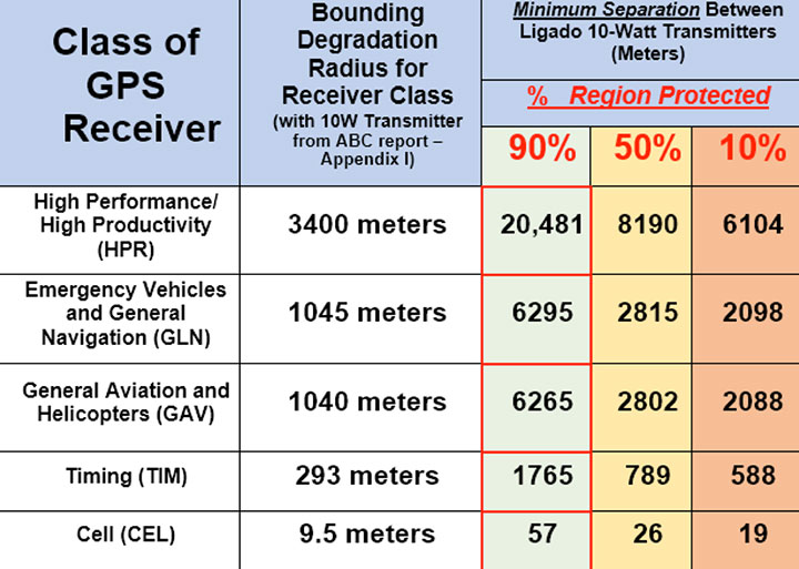
“We believe avoiding degradation over at least 90 percent of the region near Ligado transmitters is the absolute minimum protection for GPS receivers in each class. This would be a hypothetical 90 percent Protection Evaluation. This is not an endorsement of this level since, of course, all users would prefer 100 percent protection. The Department of Transportation (DOT) Adjacent Band Compatibility (ABC) study is the only validated test to verify degradation at various received power levels.
“Those results inform that to insure degradation not exceed 10 percent of the Region (90 percent Protection) for High Performance receivers, either:
Ligado maximum power can be no more than .0036 watts at the 400-meter spacing they had earlier planned. Tolerable power would be 3/10ths of 1 percent of their proposed ~10 watts. Or
the closest spacing of Ligado transmitters is 20,000 meters (over 12 miles) for their proposed ~10 watt power level (see Figure 1).”
Figure 1. The PNTAB strongly believes that 90 percent is the minimum Area Protection Criterion (maximum 10 percent degradation). (Chart: PNT Advisory Board)
The U.S. Defense Advanced Research Projects Agency (DARPA) Microsystems Technology Office is soliciting research proposals for the development of a new class of atom-based systems using integrated photonics and trapped atoms to enable high-performance, robust, portable clocks and gyroscopes.
The military researchers are asking industry to develop relatively simple portable photonic integrated circuits (PICs) for high-performance position, navigation and timing (PNT) devices as an alternative to GPS for when satnav signals are not available.
A PIC or integrated optical circuit, similar to an electronic integrated circuit, integrates multiple photonic (having to do with light) functions, providing capabilities for information signals imposed on optical wavelengths, typically in the visible spectrum or near-infrared, 850–1650 nanometers.
A-PhI Program
The Atomic-Photonic Integration (A-PhI) program seeks to develop trapped-atom based, high-performance PNT devices, reducing the complexity of these atomic systems by using PICs. According to the DARPA document, the PICs will replace the optical assembly behind devices such as sensitive and accurate angle sensors and clocks, while still enabling the necessary trapping, cooling, manipulation and interrogation of atoms.
A-PhI aims to demonstrate that compact PICs can replace the optical bench of conventional free-space optics for high-performance trapped-atom gyroscopes and trapped-atom clocks without degrading the performance of the underlying physics package.
Physics
Atomic systems using trapped atoms have the potential to be made portable while maintaining their accuracy due to the atomic trap’s small size and the inherent isolation a trap offers an atomic system from the environment, especially from acceleration.
Currently, these systems are bulky, heavy, and not notably portable, because of the complexity of the optical systems used to create the trap.
In the past, efforts to miniaturize the hundreds to thousands of optical components in such benchtop systems have relied on removing optical elements, miniaturizing the remaining elements, and tightly integrating them in a small package.
The products deliver degraded performance with the need to maintain very tight optical alignment, causing both poor environmental robustness and poor tolerance to design errors. Effective miniaturized atomic systems cannot be achieved at a reasonable cost with this approach.
Recent developments in PIC research suggest that on-chip optical frequency combs based on microresonators, optical frequency synthesis, novel on-/off-chip coupling, wavelength demultiplexers, and on-chip phased arrays for dynamic manipulation of light fields can replace optical systems with readily manufacturable, low-cost chips without the alignment sensitivity of conventional free-space optics.
Gyroscopes
A-PhI also seeks to develop proof-of-concept trapped atom gyroscopes, a matter-wave analog of the interferometric fiberoptic gyroscope. Such a miniaturization effort could generate an order of magnitude improvement in angular sensitivity and dynamic range over current free-space products.
A-PhI hopes to develop portable, high-performance, navigation and timing systems: the miniaturization of the optics of atomic systems without a decrease in performance. Subsequent work, the RFP asserts, will be required to incorporate the necessary compact and robust lasers and electronics to achieve a fully functioning, high-performance, portable PNT system.