Category: Mapping

  • Are e-bikes the transportation of the future?

    Are e-bikes the transportation of the future?

    Photo:
    Image: iStock/Getty Images Plus/Getty Images

    Bikes have been used for centuries for transportation, exercise, and recreation. Now, thanks to developments in battery technology and growing environmental concerns, sales of e-bikes are exploding.

    The Roundup has estimated that 300 million e-bikes will be used around the globe by next year, with annual sales reaching 10 million by 2024 and 17 million by 2030.

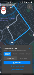
    Mapbox, a platform that provides maps and location data for developers and works with such notable companies as Strava, General Motors, and Instacart, offers micro mobility solutions to help e-bike companies develop advanced navigation systems. E-bike maker Cowboy, and shared micro-mobility operator TIER Mobility, use Mapbox for their customizable navigation technology that provides turn-by-turn navigation with voice guidance, route optimization, traffic history and more.

    Mapbox co-founder and principal evangelist Will White understands the capabilities and limitations of e-bikes that need to be considered when designing navigation technology for them. He pointed to two main obstacles to the adoption of e-bikes: rider safety and security from theft.

    With these obstacles in mind, Mapbox is developing improvements in the ability to track the precise location of e-bikes by using their navigation platform. Additionally, White predicts that most e-bike companies will start to include radar devices to detect obstacles ahead and vehicles approaching from behind, as well as cameras, artificial intelligence and more to improve rider safety.

    White is optimistic that e-bikes will be adopted as a mainstream form of transportation and is excited for Mapbox to be on the forefront of that innovative navigation technology.

  • Satellite observation is helping to map lava from Hawaii’s Mauna Loa volcano

    Satellite observation is helping to map lava from Hawaii’s Mauna Loa volcano

    Image: USGS
    Image: USGS

    In late November, the Mauna Loa volcano in Hawaii erupted for the first time since 1984 and is currently in an active volcanic eruption. Scientists are using satellites and helicopters to record and map the flow of lava on the Big Island.

    The active eruption is in a remote area on the island, making it difficult to map it and the lava flow. It is critical to have accurate emergency information during the eruption in order to have appropriate resources and have ample time to evacuate, if necessary.

    The easiest and most accurate way to map the lava from this eruption is via satellite. Based on satellite observation, scientists have been able to create a mobile app to support helicopter crews in making maps of lava flow that update in real time. This real time evaluation is sent to emergency personnel and geologists tracking the eruption patterns.


    Photo:
    Image: USGS

    Mauna Loa has erupted 33 times, the most recent of which was 38 years ago. The volcano typically averages an eruption every 5 years, making Mauna Loa’s most recent dormant period longer than normal. According to the U.S. Geological Survey (USGS), this eruption was caused by an increase in earthquakes below the Mauna Loa Summit, an increase of inflation tracked by GPS stations, and several additional geologic factors.

    Live footage of the Mauna Loa eruption can be seen here.

  • Mapbox product updates designed to enhance location technology

    Mapbox product updates designed to enhance location technology

    Mapbox, a maps and location platform, has created new products and platform updates to aid developers in making more accurate, data-driven decisions and improving overall user experience with advancement in location technology.

    Navigation SDK v2.9 was introduced to provide pre-built navigation applications, compatible with Android and IOS, which will provide all the primary navigation components across a workflow using lines of code instead of starting from square one. The Drop-in UI is customizable to create applications that reflect a developer’s brand, rather than needing to manually develop a full end-to-end application.

    Photo:
    Image: Mapbox

    Navigation SDK Copilot, a backend analytics tool for CX on navigation applications, was launched and designed by Mapbox to collect trace files of navigation sessions and search analytics data from users. Developers can use this data to gather feedback and collective user data to create touch points with users and improve application experience based on their data-drawn conclusions.

    Mapbox’s platform updates and product innovation also include improvements to its Matrix API, which can now support scheduled departure times and provide optimal driving routes creating a more accurate ETA. This innovative location technology is also designed to enhance fuel efficiency and decrease emissions.

    Photo:
    Image: Mapbox

    As map boundaries are constantly changing, Mapbox has expanded its visualization of map lines to update as frequently as the lines change. The expanded visualization makes updates quicker and improves the ability of Mapbox’s platform to give users the most up-to-date information.

  • Spirent offers SimORBIT to help developers determine LEO for lab tests

    Spirent offers SimORBIT to help developers determine LEO for lab tests

    Spirent Communications logoSpirent Communications has revealed its latest low-Earth-orbit (LEO) satellite solution software named SimORBIT, developed in partnership with space-borne receiver developer SpacePNT. The software is designed to aid developers in determining LEO orbits accurately for GNSS/PNT lab testing.

    SimORBIT calculates LEO orbits as well as their environments and intricate characteristics to provide an accurate result to developers for testing. The software replicates LEO orbits so that simulations can provide the realistic environment of a LEO satellite, including gravitational and atmospheric impacts the satellite could encounter in space.

    SimORBIT was created in partnership with spaceborne receiver developer SpacePNT. “Until now, PNT testing on LEO applications has been limited due to the lack of an integrated solution that could offer realistic LEO orbital data together with GNSS simulation capabilities,” explained Adam Price, Spirent’s vice president of PNT Simulation. “By working in close collaboration with SpacePNT, we have been able to develop the SimORBIT tool to bring a new level of accuracy and realism to LEO application testing by combining the simulation of precise LEO orbits and highly accurate GNSS signals.”

    With Spirent’s release of SimORBIT, developers can create non-ICD signals via I/Q injection, or by the Spirent “Flex” feature, generating space-centered PNT signals to be developed in the lab as realistically as possible.

  • Position Partners unveils SmartSurveyor 3–in–1 mapping tool

    Position Partners unveils SmartSurveyor 3–in–1 mapping tool

    Position Partners has unveiled SmartSurveyor, which facilitates accurate, survey-grade aerial mapping and photogrammetry without the need for a connection between a camera shutter and a GNSS receiver.

    The fully compact, handheld, aerial mapping survey rover is compatible with DJI Mavix 2 and 3 series and Phantom 4 Pro drones.

    Photo:
    Image: Position Partners

    The design is dissimilar to other drone mapping systems in that it works from a drone or smartphone and with two or more ground control points (GCPs) while using an ultra-matching technique.

    Once data is captured by SmartSurveyor, all the photos and the GNSS file are uploaded to a PC and analyzed through the Agisoft UltraMatch workflow to confirm their accuracy before they are exported. Data can be managed in the cloud or on a local PC using software designed by MapSender.

    Additionally, this mapping tool works in tandem with the AllDayRTK subscription GNSS network service so collected data can be uploaded to Tokara to remotely manage a project.

    Photo:
    Image: Position Partners
  • NGA seeks feedback on how to improve Earth modeling

    NGA seeks feedback on how to improve Earth modeling

    NGA logoThe National Geospatial-Intelligence Agency (NGA) is seeking information from the GNSS community on upgrades to its Stardust program.

    Stardust develops models of the Earth used in geomatics. The upgrades will result in modernization of geomatics information technology systems and infrastructure. The update includes migration of models to the cloud.

    The NGA posted a request for information (RFI), with responses due by 5 p.m. Eastern Time on Dec. 21.

    Stardust is run by the NGA Foundation GEOINT Integrated Program Office, partnered with the Foundation GEOINT Group (NGA/SF) within the Source Operations and Management Directorate.

  • Deformation monitoring company NavStar joins Terra Insights

    Deformation monitoring company NavStar joins Terra Insights

    Photo: NavStar
    Photo: NavStar

    NavStar — a deformation monitoring company — has joined the Terra Insights platform of geotechnical brands.

    NavStar develops specialized hardware and software for automated detection of movement on slopes and structures, with an emphasis on GPS/GNSS sensors. It provides a scalable and modular data-collection and presentation software platform.

    “NavStar perfectly complements Terra Insights’ vision of being the global platform to provide trusted geotechnical, structural and geospatial monitoring technology and data delivery solutions,” said Mark Price, CEO, Terra Insights. “NavStar’s specialized expertise in automated deformation monitoring systems from both a hardware and software perspective expands Terra Insights’ core capabilities while pushing us further into the future.”

    NavStar’s team of surveyors, engineers, technologists and software developers has been providing specialized GPS/GNSS solutions, products and support to clients around the world since 2001.

    NavStar’s specialized GeoExplorer and deformation monitoring products are used by the mining, oil and gas, power, construction and government sectors.

    “We are excited to join Terra Insights,” said Glen Bjorgan, manager of Field Operations at NavStar. ”Over the years we have worked extensively with the companies that make up the Terra Insights platform. Through that experience, we know that Terra Insights will be a great fit for NavStar and our customers.”

  • Waterway Guide and marine tech company savvy navvy enter partnership

    Waterway Guide and marine tech company savvy navvy enter partnership

    A new partnership between all-in-one navigation app and Waterway Guide gives U.S. boaters an enhanced user experience, integrating comprehensive marina details and user reviews into the navigation app.

    The savvy navvy app, described as “Google Maps for boaters”, has grown by 132% this year in the United States.

    Waterway Guide is a resource for cruising boaters. Its data on more than 4,000 marinas and thousands of anchorages are now integrated into the savvy navvy app for all the users to access.

    “One of the most significant factors in deciding where to go with your boat is reviews from other boaters,” said Jelte Liebrand, CEO and founder of savvy navvy. “With a wealth of information on all marinas and anchorages and honest reviews, it’s an amazing addition to our offering for our growing American customer base.”

    Image: savvy navvy
    Image: savvy navvy

    Liebrand, a former Google software engineer and avid sailor based in the UK, developed and launched savvy navvy, bringing an all-in-one navigation solution to the market. This season alone savvy navvy users have plotted more than 40 million nautical miles of routes. Earlier this year, the navigation app launched a freemium plan and functionalities for paddleboarders, kayakers and jet skiers.

    Waterway Guide is continuously updated by a network of on-the-water contributors, marina partners, NOAA data, the Waterway Guide team, and crowd-sourced information.

    Data from the Waterway Guide is live in the savvy navvy app for users to see now when pressing the blue POI icons across the United States and Canada, giving users  information on services and facilities alongside marina reviews.

  • Fugro joins forces with Carbonix on remote aerial operations

    Fugro joins forces with Carbonix on remote aerial operations

    The Carbonix Volanti vertical take-off and landing (VTOL) drone. (Photo: Carbonix)
    The Carbonix Volanti vertical take-off and landing (VTOL) drone. (Photo: Carbonix)

    Fugro is partnering with Australian drone manufacturer Carbonix to establish a new long-range drone capability. It is Fugro’s first partnership working towards long-range beyond-visual-line-of-sight (BVLOS) missions, bolstering Fugro’s existing geographic information system (GIS) capability.

    Carbonix will supply Volanti and Ottano vertical take-off and landing (VTOL) drones over the next 27 months, to further enhance Fugro’s remote operations.

    Fugro is engaged in the transition to remote and autonomous operations with a global network of nine remote operation centres (ROCs). From these centers, Fugro operates boats and other vehicles, and provides survey, inspection and piloting services to the global maritime industry.

    Carbonix will support Fugro’s Australian long-range maritime and land projects from the sky, using aerial surveying and data-capture technology, while integrating with Fugro’s ROCs for the joint development of systems technology and capabilities.

  • Nexar releases CityStream Live, a real-time mapping platform for mobility

    Nexar releases CityStream Live, a real-time mapping platform for mobility

    Image: Nexar
    Image: Nexar

    The new platform is designed to provide fresh data on nearly every road across the U.S. at a reduced cost

    Nexar, an artificial-intelligence (AI) computer vision company, has released CityStream Live, a real-time mapping platform.

    CityStream Live enables the mobility industry, including connected vehicles, maps, mobility services, digital twins or smart city applications, to access a continuous stream of fresh, crowdsourced road data. Only with real-time data can vehicles really know what’s coming their way, react to varying speed limits, avoid work zones, find parking and someday drive themselves. Thanks to Nexar’s massive network of “eyes on the road,” edge AI and change-detection capabilities, CityStream Live is already available to industry design partners.

    Today’s digital maps often fall short of the freshness and precision that software-driven auto OEMs, autonomous vehicles, and mobility players require. Standard mapping methods — SD, HD and traffic maps — fail to provide accurate, up-to-date and cost-effective solutions, Nexar said.

    To solve this problem, CityStream Live provides real-time mapping technologies at the edge of the network, enabling detection of work zones, road sign changes, potholes and free parking spaces. The platform is designed to provide fresh data on nearly every road across the United States at a dramatically reduced cost.

    CityStream Live uses a crowdsourcing network and edge AI software to provide developers with a live data feed to increase situational awareness, enhance driving capabilities, increase safety, add comfort and help solve everyday mobility challenges.

    More than 700,000 vehicles are in in Nexar’s camera network, which captures 94% of U.S. roads each month. Nexar collects 3 billion miles of road vision data per year.

    A free trial version of CityStream Live can be accessed here.

  • NV5 Geospatial uses remote sensing for utility distribution management

    NV5 Geospatial uses remote sensing for utility distribution management

    NV5 Geospatial's distribution network data shows pole usage. (Image: Nv5 Geospatial)
    NV5 Geospatial’s distribution network data shows pole usage. (Image: Nv5 Geospatial)

    Asset and vegetation management applications help utilities minimize risk and improve the reliability of electric distribution networks

    Geospatial data firm NV5 Geospatial is applying remote-sensing data analysis to improve the way utilities manage their distribution networks. The company mapped more than 5.5 million miles of utility distribution networks in the United States using a combination of lidar and orthoimagery sensors on mobile and airborne platforms to acquire data for both asset and vegetation management.

    Analysis of this geospatial data enables electric utilities to minimize risk and maximize reliability, while increasing efficiency.

    “An aging grid, workforce shortages, increasing energy demands and an uptick in major weather events are combining to create a perfect storm that could impact reliability, customer service and safety for electric utilities across the country,” said Eric Merten, vice president, Commercial Group at NV5 Geospatial. “A boots-on-the-ground approach to management cannot keep up with demands related to aging equipment, compliance, pole loading and vegetation encroaching on infrastructure.

    “NV5 Geospatial’s innovative remote-sensing applications and data analysis tools give utilities the power to proactively address problems in their distribution network before they impact operations or customers,” Merten said.

    A distribution network (purple) and vegetation risks (red/yellow pins). (Image: NV5 Geospatial)
    A distribution network (purple) and vegetation risks (red/yellow pins). (Image: NV5 Geospatial)

    Built on the success of its remote-sensing applications for utility transmission networks, NV5 Geospatial’s distribution management solutions offer end-to-end capabilities — from acquiring accurate, high-quality geospatial data to data analysis and visualization using custom viewers and enterprise geospatial information systems (GIS) — and can be customized to meet the use cases and budgets of utility companies.

    Using NV5 Geospatial’s tools, distribution network asset managers can achieve compliance with National Electrical Safety Code (NESC) clearance guidelines, and get clear visibility into joint use of poles to prevent pirating.

    The NV5 Geospatial remote-sensing data also can help quantify vegetation with distribution rights-of-way and determine risk based on proximity to wires and poles.

  • Xplore and UP42 partner to bring satellite data to geospatial customers

    Xplore and UP42 partner to bring satellite data to geospatial customers

    Xplore's multi-sensor XCRAFT satellite. (Image: Xplore)
    Xplore’s multi-sensor XCRAFT satellite. (Image: Xplore)

    The agreement will enable direct access to Xplore’s satellite tasking and archive of high-resolution data

    Xplore Inc., a commercial space company providing space as a service, has signed a partnership agreement with UP42, a geospatial developer platform and marketplace. The agreement will enable direct access to Xplore’s satellite tasking and archive of high-resolution data.

    Xplore’s XCRAFT satellite platform is engineered to collect data with multiple instruments including still and video imagery, hyperspectral, ultraviolet and infrared spectroscopy. Xplore’s satellite is capable of achieving user-defined video flyovers.

    Data generated with Xplore’s diverse sensors will address a wide variety of use cases across the Earth observation industry including agriculture, forestry, oil and gas, maritime, change detection and intelligence, and creative media content. Additionally, customers can obtain more informative, rich layers of data from Xplore’s data-fusion products.

    The combined power of bringing Xplore’s high-value imagery products to market via the UP42 platform will accelerate the commercial use of private remote-sensing data, according to Xplore.