The Caribbean Division of The Nature Conservancy (TNC) has focused on monitoring, protecting and restoring the region’s marine environments for more than 40 years. As the plight of coral reefs has become more urgent, so too have TNC’s efforts to tackle coral conservation, and meet the demands for better maps.
“Reef maps are an essential tool for coral resource managers, but historically these maps have had insufficient detail, been outdated or been produced for small areas,” said Steve Schill, TNC marine conservation specialist. “Not having access to accurate, large-area reef maps has limited our understanding of these ecosystems and the benefits they provide.”
Having used Trimble’s eCognition object-based image analysis (OBIA) software for automatically classifying and mapping small reef areas, Schill believed eCognition could be the enabling, scalable approach to map the hundreds of thousands of reefs across the region.
Schill worked with technical professionals at Earth observation company Planet and researchers at Arizona State University to select 30,000 4-meter-resolution scenes from the Dove satellite constellation. The team then created a seamless mosaic of the whole Caribbean basin. He also partnered with eCognition specialists Tama Group to develop the OBIA method to automatically classify benthic habitats.
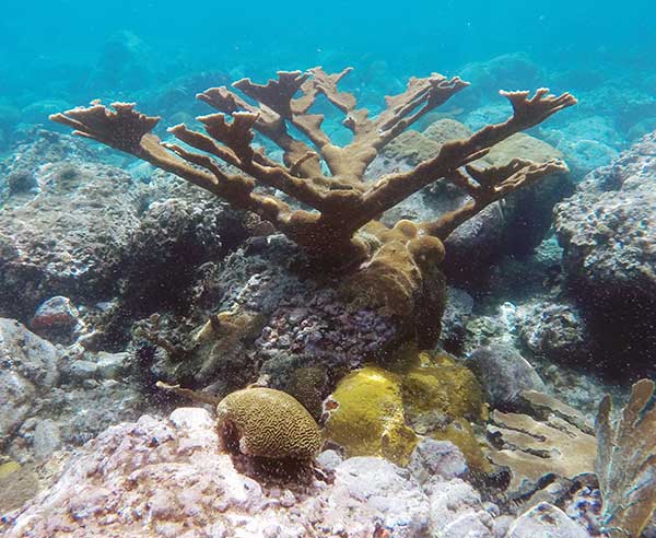
Image: TNC and Tama Group
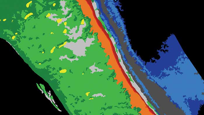
To map reefs, Tama Group experts integrated the Dove satellite surface reflectance and Dove-derived bathymetry into eCognition. The software first delineates land and sea areas deeper than 15 meters. Based on depth data and known topographic characteristics, it then categorizes the overall reef structure, distinguishing reef crest, fore reef, back reef, patch and fringing reef. Once it defines the five reef classes, eCognition determines seagrass classes (dense and sparse), sand types and dredged areas, and then finishes with mapping the deeper hard-bottom-with-algae classes. In total, the software automatically classifies 13 different benthic habitats.
Using this workflow, eCognition successfully classified the shallow water benthic habitats of the entire Caribbean Basin in four months. The software exported each area as vector shapefiles, and Schill and his team downloaded them for analysis and quality control. Moving from reef to reef, they used field data to analyze the accuracy of the classifications, making manual corrections where needed.
To date, benthic habitat maps have been produced for 23 countries and territories across the insular Caribbean. In October, the final full set of benthic habitat maps for the insular Caribbean will be available online.
Mobile GIS Services (MGISS) has equipped a team of urban surveyors with new satellite positioning systems to accurately map assets and features such as signage, lighting and landscape features. The technology supplied by MGISS included Leica smart antennas coupled with data management and mapping software.
For this project, MGISS worked with Occam’s Razor Consulting Limited (ORCL), a specialist in data capture for landowners, to achieve centimeter accurate asset mapping for open spaces and park management. ORCL works for local authorities and housing associations and due to the blocking effects of tall buildings and trees, its existing equipment was not capable of achieving the required levels of accuracy, MGISS said.
According to MGISS, ORCL had previously been using the Leica GG03 antennas with Leica rugged tablet computer computers. MGISS then recommended ORCL use the GG04 plus Leica smart antenna. ORCL is now operating its new smart antenna with a Leica controller running Zeno Field (an OEM version of ArcPad 10) software.
According to MGISS, in addition to the ArcPad GIS functionality, Zeno Field provides GNSS raw data logging, easy handling of GNSS configurations, feature accuracy management and an automated workflow between the field and office. ORCL also uses Laser Technology TruPulse rangefinders and Leica Smartnet for its RTK service, all specified and supplied by MGISS. Working with MGISS ORCL will monitor its current workflows as the software develops to support LTI laser rangefinders and will continue to explore new applications, MGISS said.
“We were interested in very high performance equipment capable of achieving centimeter accuracy in difficult urban canyon conditions and under dense tree canopies,” said David Brown, managing director of Occam’s Razor Consulting. “The new MGISS solution has slotted straight into our existing workflows without any issues at all and is a clear improvement on our previous system. The devices track the newer Galileo constellation, as well as the more established American and Russian satellites, reaching centimeter accuracy quickly and holding the signal well overcoming the challenges of tall buildings and trees.”
To prevent the further spread of COVID-19, the world is shifting to a “new normal” in which social distancing is practiced and contact between people is avoided. Due to early evidence suggesting the spread of COVID-19 is much more aggressive indoors than outdoors, many companies have begun efforts to monitor workers’ movements and trace contacts to keep offices and factories from becoming new epicenters of infection.
The Need to Monitor
Keeping a safe distance from others and avoiding contact is essential to prevent getting infected with COVID-19. However, there are many situations where avoiding contact with others at indoor locations such as offices and factories is difficult. Hence, there is a growing need for technologies that monitor contact between workers and their movement histories in real time.
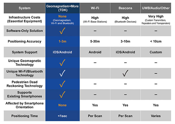
Indoor location information can be obtained using various wireless communication technologies including Wi-Fi, Bluetooth and ultra-wideband (UWB). For example, Bluetooth beacons have been deployed at commercial facilities to enable services that provide location-relevant information to customers with smartphones. The positioning accuracy of Bluetooth, however, is only around 3 to 10 meters and is dependent on infrastructure installation.
To be useful for contact tracing of infectious diseases, the number of beacons must be increased to achieve an adequate level of accuracy. UWB technology features high positioning accuracy, but deployment in a wide area would require installation of a large number of radio transceivers and repeaters, putting it at a cost disadvantage.
Solution Based on Geomagnetism
Given this background, a solution using geomagnetism is attracting attention. TDK has developed VENUE, which displays the real-time locations of people by utilizing geomagnetic sensors found in today’s smartphones. Each indoor location has a geomagnetic signature that can be used to ascertain the position of the phone.
There are several approaches to indoor positioning, but geomagnetism, tightly coupled with inertial navigation, optimally balances accuracy, reliability and cost of deployment and maintenance.
“The beauty of geomagnetic positioning is that it works in all large venues whose structures interfere with Earth’s magnetic field, making this an infrastructure-free approach to indoor positioning that is accurate to better than 2 meters,” said Chris Goodall, founder and managing director of Trusted Positioning Inc., a TDK Group Company based in Calgary, Alberta, Canada.
VENUE provides a position display with even higher accuracy by combining geomagnetic information with information from accelerometers and gyroscopic sensors inside smartphones.
VENUE requires only the creation of a geomagnetic map that combines an indoor layout map with the geomagnetic data of that particular location acquired through a survey, with no need to install new devices and terminals. This leads to low installation cost. The accuracy of positioning using geomagnetism is better than two meters (6 feet) — sufficient for tracing contact with infected persons. In addition, VENUE provides a position display with even higher accuracy by combining geomagnetic information with information from accelerometers and gyroscopic sensors inside smartphones.
“People may hold their smartphones while walking or put them in their pockets or bags,” Goodall said. “Since the orientation to the user changes constantly, the movements and pedestrian use cases need to be corrected using inertial sensors. Solving these issues was the greatest challenge for practical applications such as tracking, and took our team many years to create, perfect and protect.”
Comparison of indoor location information technologies. (Chart: Trusted Positioning)
Real-World Trial Under Way
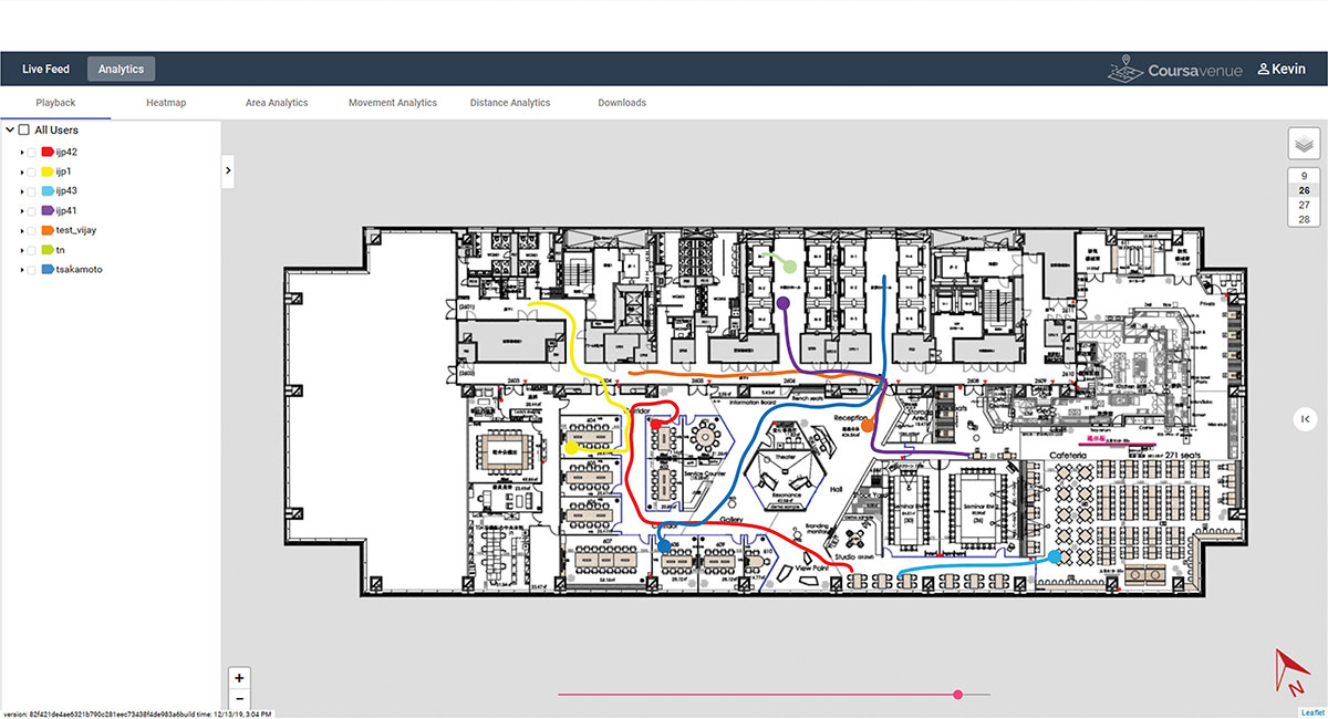
Beginning in August, a contact tracing trial among workers is being conducted at TDK’s headquarters in Nihonbashi, Tokyo, using VENUE. Employees carry smartphones with a special app installed, and their positions and movement histories on the floor are combined with anonymous identification information. If an employee is found to be infected, the data will be analyzed to identify people who had contact with that employee within the preceding two weeks, and measures such as stay-at-home instruction will be taken.
This solution not only can identify those who were in close contact with the infected person as primary contacts, but also trace those who stayed in areas where the infected person had been shortly before as potential “area contacts.” Analysis that combines location and elapsed time enables more effective contact tracing by improving primary contact tracing indoors and enabling area-based contact tracing over time.
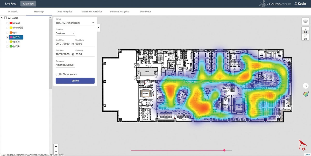
Ongoing Trial at TDK Headquarters: VENUE displays an individual worker’s tracking data on the dashboard. (Conceptual illustration: Trusted Positioning)Ongoing Trial at TDK Headquarters: A worker’s durations of stay and positions can be visualized in the form of a heat map. (Conceptual illustration: Trusted Positioning)
New Possibilities Opened
Because VENUE can display the positions and histories of people and objects using not only workers’ smartphones but special tags containing geomagnetic and inertial sensors (under development), it can be deployed for a wide range of applications beyond contact-tracing of infectious diseases. Possible uses include monitoring the flow of employees to improve operational efficiency or tracking positions of equipment to manage their operational statuses. TDK is working with a number of companies on solutions to improve business efficiencies using location information.
Many offices have introduced open seating, so maintaining a “real-time seating chart” using VENUE is a real advantage so staff can more easily find one another in large office settings, encouraging more collaboration between staff and departments.
Companies have been using Bluetooth low-energy (BLE) beacons to manage the movement of workers, materials and equipment indoors in warehouses, factories and construction sites. VENUE can reduce the installation and maintenance costs of such systems, especially in large-scale facilities.
VENUE is also useful for other contact-tracing applications that do not focus on viral transmission, such as human-to-machine, human-to-vehicle and human-to-robot contacts. The future work environment will undoubtedly change with more automation, and the interaction of humans and machines poses safety concerns. VENUE’s designers hope it can improve safety in many types of contact-tracing applications.
Similar to the expansion of GPS for outdoor positioning applications, indoor positioning technologies will likely grow in our everyday lives. VENUE is one indoor location information solution that enables highly accurate location information to be obtained while keeping infrastructure costs down.
NEXTMap digital surface model (Image: Intermap Technologies)
The NEXTMap Elevation Data Suite from Intermap Technologies is now offered on the UP42 developer platform for Earth observation data and analytics. UP42 gives users direct access to extensive Earth observation datasets and advanced processing algorithms, and Intermap Technologies, based in Englewood, Colorado, is a provider of geospatial datasets, solutions and software.
The NEXTMap 3D elevation products are available as digital surface models and digital terrain models at one-, five- and 10-meter resolution. According to Intermap, NEXTMap One offers 1-meter spatial resolution, 1-meter vertical and 3.5-meter horizontal accuracy; NEXTMap 5 offers 5-meter resolution, 1.6-meter vertical and 3.5-meter horizontal accuracy; and NEXTMap 10 offers 10-meter resolution, 8.4-meter vertical and 17.5-meter horizontal accuracy.
“We are excited to add NEXTMap elevation models to the UP42 platform. Our customers need this data for a range of use cases, including monitoring of vital infrastructure projects such as pipelines, powerlines and railway corridors,” said Sean Wiid, CEO of UP42. “High-quality 3D data is critical in every phase of infrastructure management from construction planning to ongoing monitoring of vegetation encroachment.”
The addition of NEXTMap datasets to the UP42 marketplace enables users to build even more powerful geospatial solutions in the areas of infrastructure management, construction planning, geologic mapping, land cover classification, forestry, resource conservation and contour generation, UP42 said.
“Our goal at UP42 is to create a single platform where our users have access to all the geospatial data, analytics and processing infrastructure they need to build solutions that solve critical real world problems,” said Wiid. “Intermap’s NEXTMap elevation models dramatically expand our core data offering and, as a result, expand the range of use cases we can help our customers address.”
The NEXTMap datasets join a variety of Earth observation information already on the UP42 marketplace, including Pleiades 1A/B, SPOT 6/7, Landsat-8, TerraSar-X, Sentinel-2 and MODIS satellite imagery, Getmapping U.K. aerial data, exactEarth AIS data, and Meteomatics weather and ocean data.
The full GNSS User Technology Report 2020 is available for download. (Cover: GSA)
News from the European GNSS Agency
The European GNSS Agency (GSA) has released its latest GNSS User Technology Report, providing a comprehensive analysis of GNSS trends and developments.
With four GNSS available and more than 100 satellites in operation broadcasting multiple frequencies, the GNSS industry is shifting towards the wide adoption of multifrequency receivers across market segments to meet the diverging user needs of emerging applications.
The report includes contributions from leading GNSS receiver, chipset manufacturers and service providers, and serves as a valuable tool to support planning and decision-making with regards to developing, purchasing and using GNSS technology.
Published biennially since 2016, the User Technology Report has become a point of reference for the GNSS industry, research and policy-makers.
Rapid Evolution
‘’The GNSS industry is evolving at a rapid pace and is shaped by the dynamics of emerging applications and user needs as well as the upgrade of existing and new GNSS and Satellite Based Augmentation Systems (SBAS),” said Rodrigo da Costa, GSA executive director. “The industry has understood the potential of Galileo’s unique features.”
The third edition of the report begins with a chapter devoted to technology trends common to all segments: receiver design, position processing and signal processing. It also discusses protection measures against GNSS jamming and spoofing, such as authentication, including what 5G and other technologies and sensors can do, in combination with GNSS.
With multi-constellation now being the norm, the industry is moving towards the wide adoption of multi-frequency receivers even for usually power- and cost-constrained consumer solutions. The Galileo E5 is becoming the preferred frequency with about 20% of all receiver models in the market already using it.
The report is built around four macro segments defined on the basis of commonalities from a technology point of view:
high volume
safety- and liability-critical
high-accuracy
timing devices and solutions (a new-entry in this edition)
Each chapter starts with the macrosegment characteristics and receiver capabilities, depicts the industry landscape and typical receiver form factor, it then delves into the key current and future drivers and trends, and finishes with the added value of the EGNSS, Galileo and EGNOS, for the macrosegment at stake.
Space Data for Europe
This year editor’s special “Space Data for Europe” sheds light on the role that Copernicus and Galileo play within the European Space Programme in the data management and use, now and in the future. It also provides a vision of major transformations underway within our society and our economy and the benefits expected from this digital transformation, paving the way towards the European Data Strategy and Green Deal.
“Today, Galileo and EGNOS already provide increased capabilities which are being used across a broad range of applications, and are already igniting the next generation of location-based applications. In the future, new services — the Galileo High Accuracy Service (HAS), Galileo Open Service Navigation Message Authentication (OS-NMA) and Commercial Augmentation Service (CAS) — will raise the accuracy and reliability bar even higher, and dramatically enhance positioning, navigation and timing solutions for businesses and citizens.
By bringing insight and understanding into the evolutions of GNSS technology, we are creating opportunities for innovation,” concluded da Costa.
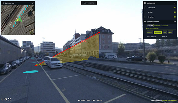
Luciad 2020.1 provides capabilities with panoramic imagery. (Screenshot: Hexagon Geospatial)
Luciad 2020.1 features dynamic panoramic imagery capabilities and immersive 3D imagery
Hexagon’s Geospatial division has launched Luciad 2020.1, a significant update to its platform for building advanced location intelligence and real-time, situational awareness applications.
Luciad 2020.1 delivers immersive 3D experiences with 360-degree panoramic imagery support that can be combined with other 3D data layers for geospatial applications. The latest release also features additional styling for 3D meshes and 3D data integration capabilities.
Visualization and Analysis
Hexagon’s Luciad portfolio allows developers to create powerful, high-performance applications that leverage data from any source for visualization and analysis in 2D and 3D. Combining static, dynamic and real-time data, including moving tracks, Luciad-powered applications support defense, aviation, infrastructure and other critical sectors.
For the 2020.1 release of LuciadRIA, which is used for building browser-based solutions, Hexagon has added 360-degree panoramic imagery capabilities that can be combined with other 3D data layers to provide complete imagery coverage and detailed information about a location. Panoramic imagery puts users in control of what they want to look at within an image. The panoramic 3D experience is powered by a new streaming imagery data service in LuciadFusion, Hexagon’s OGC-compliant server solution.
“With the addition of panoramic imagery capabilities and other 3D data enhancements, Luciad 2020.1 puts local governments, transportation departments, utility companies and others in control of what they can observe and analyze within a particular scene,” said Mladen Stojic, president of Hexagon’s Geospatial division. “With these capabilities, organizations can remotely monitor their assets and infrastructure, significantly reduce manual inspection processes and fully leverage location intelligence across the enterprise.”
More New Features
The release contains other new features and improvements requested by customers, including:
military grid coordinate transformations
non-georeferenced WebGL-based views
improved imagery sampling
additional format support and upgrades.
For defense customers, the Luciad 2020.1 release consolidates its military symbology support across all Luciad platforms and programming languages.
NASA took on a Herculean precision positioning task that culminated Oct. 20 with a spacecraft sampling the surface of an asteroid from a 5-meter area — a NASA first.
The OSIRIS-REx spacecraft, launched on Sept. 8, 2016, spent two years mapping the Bennu asteroid to determine the best site for removing the sample. Bennu was selected because of its near-Earth position (a mere 200 million miles away) as well as its age. It’s considered a primitive remnant from the formation of the solar system. It’s the smallest body a spacecraft has ever orbited.
The infrared spectrometer on OSIRIS-REx confirmed Bennu was sandy, but photos showed it to be an unrelenting rockscape dominated by boulders. Because of this difficult terrain, the planned sample site was reduced from 50 meters to 5 meters, an area smaller than a parking lot. “This required us to rethink how to navigate to the surface and come up with new ideas,” said Coralie Adam, TAG navigation manager for KinetX Aerospace. TAG stands for Touch-And-Go, the sample-collecting procedure.
The mapping method changed from using a lidar-based technique to an optical-based technique. “When we saw what Bennu looked like, we realized we had to switch to a vision-based approach, and that’s the NFT system,” explained Mike Moreau, Osiris Rex deputy project manager, Goddard Space Flight Center.
The Natural Feature Tracking (NFT) was added to the mission at the critical design review stage. NFT is an onboard optical navigation system that compares observed images to a set of asteroid terrain models rendered in real-time from a catalog stored in the flight computer’s memory. Onboard knowledge of the spacecraft state is then updated by a Kalman filter using the measured residuals between the rendered reference images and the actual observed images. (Read a technical paper on NFT.)
The asteroid terrain models used by NFT are built from a shape model generated from observations collected during earlier phases of the mission and include both terrain shape and albedo information about the asteroid surface.
“The KinetX navigation team spent last two years to learning how to navigate around Bennu using optical navigation techniques,” Adam said. She explained that every few minutes, a navigation camera takes an image of the features below and sends it to the NFT. The system identifies features in the image and sends a signal back to Earth.” The KinetX team worked with the Lockheed Martin team to map the surface of Bennu to a resolution of 2 centimeters per pixel.
With this observational data, the team created a hazard map. With position uncertainty down to half a meter, a sample site dubbed Nightingale was successfully contacted, and 2 ounces of regolith collected.
The team included mission managers from the University of Arizona, Lockheed Martin, and NASA’s Goddard Space Flight Center.
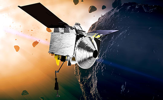
The Origins, Spectral Interpretation, Resource Identification, Security-Regolith Explorer (Osiris-REx) spacecraft
is scheduled to depart Bennu in 2021, and to deliver the collected sample to Earth on Sep. 24, 2023. It will be the first U.S. mission to carry samples from an asteroid back to Earth, and the largest sample returned since the Apollo missions.
Artist’s concept of the OSIRIS-REx spacecraft orbiting the Bennu asteroid. (Image: NASA)
“Seen & Heard” is a monthly feature of GPS World magazine, traveling the world to capture interesting and unusual news stories involving the GNSS/PNT industry.
The Mayflower autonomous ship. (Photo: Tom Barnes for IBM)
No pilgrims needed aboard
The autonomous Mayflower trimaran launched Sept. 16 from Plymouth, England, on a mission to traverse oceans and gather vital environmental data, guided by Veripos GNSS and inertial measurement units from iXBlue and Silicon Sensing. Ocean research non-profit ProMare joined with IBM on the Mayflower Autonomous Ship — an artificial intelligence and solar-powered marine research vessel, two years in the making. Designed to provide a safe, flexible and cost-effective way of gathering data about the ocean, the Mayflower works in tandem with scientists and other autonomous vessels to help understand critical issues such as global warming, micro-plastic pollution and marine mammal conservation.
Photo: nycshooter/E+/Getty Images
A Guardian on the Bus
A school bus app aims to help monitor students’ exposure to others. App developer CalAmp’s Bus Guardian uses the same technology from its Here Comes the Bus app with an added layer of contact tracing. With Bus Guardian, parents can opt-in and invite their student to check on and off the bus. It uses telematics to convert a school bus into a contact tracing solution. Schools can deliver instant and actionable reports of ridership based on contact tracing — important if a student or driver becomes ill.
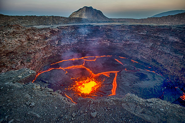
The Erta Ale volcano. (Photo: guenterguni/E+/Getty Image)
Rift splits Africa in two…eventually
GPS data is refining predictions of when Africa will split into two continents. In 5 to 10 million years , the Gulf of Aden and the Red Sea will flood the Afar region and the East African Rift Valley, creating a new ocean and continent. GPS data is precisely measuring ground movement as three tectonic plates peel away from each other at a triple junction, said Ken Macdonald, professor emeritus, University of California, Santa Barbara. “With GPS measurements, you can measure rates of movement down to a few millimeters per year,” Macdonald said. “As we get more and more measurements from GPS, we can get a much greater sense of what’s going on.”
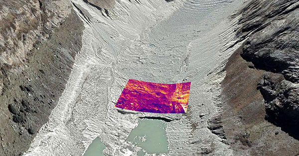
Image: Rosie Bisset
Dangerous Retreat
In a first for mapping glacier retreat in the Peruvian Andes, the CASCADA UK + Peru glacier project used a drone fitted with a FLIR Vue Pro R 640 thermal-imaging camera for insight. A thicker layer acts as insulation. Researcher Rosie Bisset, Edinburgh University, is building a mosaic of the images to better understand how surface cover is affecting the melt rate. The glaciers have shrunk by about 30% in the past few decades, and pose a serious threat to the water supply of in the Ancash region.
Esri has released a new mapping app, Air Quality Aware, that fuses data from the EPA’s AirNow program, NOAA’s National Weather Service wind forecast and the American Community Survey to provide location intelligence on current air quality and its impacts on local communities.
At a national level, areas are color-coded according to EPA’s Air Quality Index, with magenta and purple representing hazardous and very unhealthy air quality.
As users zoom in, the map shows the air-quality scores reported at each individual air-quality monitoring station.
Users can click on any station for more information about the pollutants and concentrations reported at that location. They can also search for or click any place on the map to get more information about current and forecasts of air quality, wind speed and insights about the vulnerable population in each place.
Eos Locate for Collector for ArcGIS underground mapping is now compatible with three Subsite Electronics products.
Introduced in 2019 by Eos Positioning Systems, Eos Locate is a real-time, survey-grade solution for mapping underground utilities with ArcGIS field apps. With Eos Locate, one field worker can collect both GNSS locations and locator data (such as depth below cover) for any buried asset including water, sewer, electric, cable, gas, fiber infrastructure and more. They can do so quickly, accurately and without the need for any additional field or office support.
The solution requires an Arrow GNSS receiver, Esri licensing, an iOS device, and a compatible locator.
This expansion adds compatibility for two new utility locator models and one HDD guidance system: the UtiliGuard (with Bluetooth option enabled), UtiliGuard 2, and TK Recon. Eos Locate for Collector combines three core technologies: Eos Arrow GNSS receivers, Esri Collector and the Vivax-Metrotech vLoc Series of locator devices.
“We are extremely excited to expand this popular underground mapping solution to Subsite Electronics customers,” said Eos Chief Technology Officer Jean-Yves Lauture. “Utilities have been asking us to add compatibility, and we are pleased to announce that this integration is now available today, for no extra cost, to our existing customers.”
“At Subsite, we are constantly listening to customer needs and providing solutions accordingly,” Subsite Electronics Senior Product Manager Christopher Thompson said. “We have a lot of customers who perform this type of work, and by partnering with Eos, we are able to provide a solution today to continue providing our customers with the tools and technology for total underground awareness.”
Thanks to the TK Recon integration, it is now possible to map horizontal directional drilling operations in real-time with Eos Locate, for both performing as-built reports and monitoring.
To use Eos Locate with Subsite devices, customers must download Eos Tools Pro (version 1.89 and higher) from the App Store for free. Eos Locate is compatible with both Esri ArcGIS Collector and ArcGIS Field Maps. Follow this manual or watch these video tutorials to get started.
Esri has acquired nFrames, a technology company that develops SURE, an imagery and lidar 3D surface reconstruction software.
According to Esri, this will enable the fusion of imagery with 3D GIS, allowing nFrames and Esri users to seamlessly capture and analyze 3D data from aerial, drone and ground-based sensors in an automated end-to-end process.
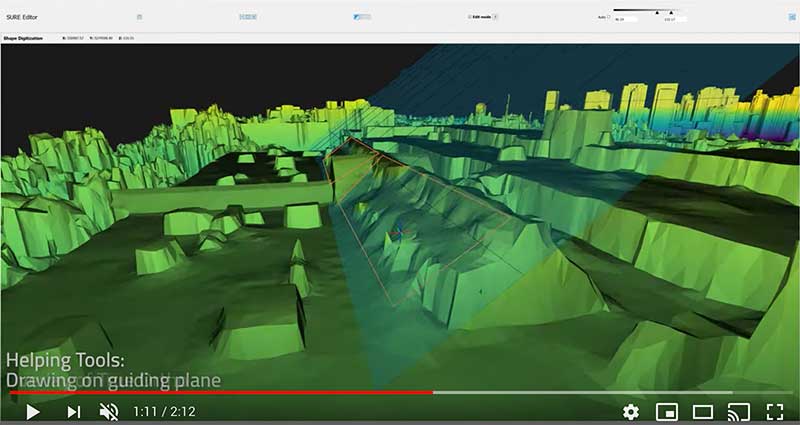
SURE scales 3D data creation to large city and countrywide airborne image datasets and projects. According to nFrames, it gives professional photogrammetry workflows improved precision, speed and simplicity on premises or in the cloud. SURE can be used for a number of industries, including those in government; national mapping; insurance; and architecture, engineering, and construction (AEC).
Through this acquisition, Esri gains a robust production engine that transforms imagery and lidar data into point clouds, phototextured 3D meshes and true orthos, Esri said.
SURE software editor (Screenshot: nFrames)
In addition, SURE allows its users to generate 3D maps at scales from individual construction sites to entire cities and countries. These maps are fully automated at high resolution and repetition rates, nFrames added.
“nFrames is a leading provider of 3D image reconstruction software and services, and I am excited to welcome the company to the Esri family,” said Jack Dangermond, Esri founder and president. “As Esri continues down its path of innovation to create a multidimensional experience, this acquisition enhances our ability to create extremely high-quality 3D data from imagery, which is critical for our customers in the municipal, planning and AEC industries.”
SURE software will become a part of Esri’s ArcGIS platform. According to Esri, it will make SURE capabilities available in ArcGIS Drone2Map and Site Scan for ArcGIS so users can create better meshes, point clouds and true orthos from their drone imagery.
“Together with Esri, we will be able to unlock the full value of 3D surface data through GIS by connecting geometry with metainformation to provide spatial context,” said Konrad Wenzel, CEO and co-founder of nFrames. “This fully automatic chain from data capture to analytics will enable smarter decision-making.”
The nFrames headquarters will now serve as a new Esri research and development center based in Stuttgart, Germany.
Innovate UK, the United Kingdom’s innovation agency, has selected Hexagon’s Geospatial division to conduct a research project that will result in faster and higher-precision mapping of railway infrastructure through the use of artificial intelligence.
The project is funded by Network Rail, the owner and operator of Great Britain’s railway infrastructure, under its R&D portfolio and delivered by Innovate UK through the SBRI competition, Innovation in Automated Survey Processing for Railway Structure Gauging, Phase One. A small group of teams was selected for this effort.
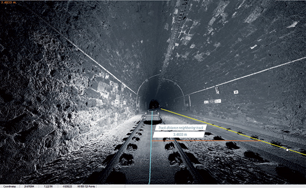
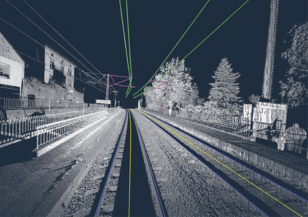
Image: Hexagon
The project will enable Network Rail to automatically identify and measure railway structures from lidar data, saving valuable time and resources, while also improving planning and operations across the rail network. The current, manual process takes analysts months or even years due to the size of the data and the labor-intensive tasks involved.
“The combination of cross-sectional area, shape, length and speed all place a space requirement on today’s railway,” said James Sweeney, senior engineer at Network Rail. “We anticipate this project will offer us a more efficient way to capture, analyse and measure railway features along 20,000 miles of track, which is important to railway safety and the growth and capacity of our network.”
Network Rail collects detailed information about its track and the surrounding features, such as bridges and tunnels. The data is then analyzed to assess clearances between trains and the infrastructure around them, which is key to safety.
Image: Hexagon
The new project aims to automate the extraction and calculation of railway features from sensor data, leveraging AI to automatically analyze point-cloud data, identify different structure types, and perform measurements on the structures. The data will be collected from reality capture solutions from Hexagon’s Geosystems division.
“Network Rail, supported by Innovate UK, is leading the way in the use of AI to automate rail structure identification and measurement,” said Mladen Stojic, president of Hexagon’s Geospatial division. “We are excited to be part of a project that can help transform the gauging process for UK railways.”