Jan Leyssens, product manager at Septentrio, gives details on the low-power AsteRx-m UAS, which offers centimeter-level accurate geotagging of images, stabilized VTOL hovering and solid interference mitigation.
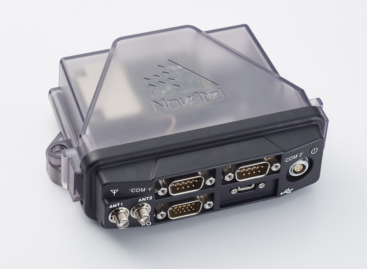
The compact FlexPak6 receiver houses NovAtel’s OEM628 triple-frequency plus L-band GNSS receiver board. It tracks all current and future GNSS constellations, with a highly configurable interface designed to meet current and future positioning and integration needs. The FlexPak6 is a GPS and GLONASS receiver that is also Galileo and Compass ready. Upgradable receiver firmware ensures easy updating to future signals. While multi-constellation tracking provides higher solution availability and reliability, its flexible communication interface broadens deployment options. It provides 100-Hz measurements for high dynamic applications. Signals tracked include L1, L2 and L2C and L5. It also has RT-2, ALIGN, GLIDE, RAIM firmware options.
Single- or dual-antenna receiver with latest algorithms
AsteRx-U dual-antenna receiver.
The AsteRx-U receiver incorporates the latest GNSS tracking and positioning algorithms, such as LOCK+ technology to maintain tracking during heavy vibration machine use and IONO+ technology to assure accuracy in regions of elevated ionospheric activity. Interference mitigation counteracts ambient and deliberate RF interference. The AsteRX-U is built around Septentrio’s latest application-specific integrated circuit (ASIC), the GReCo4, and incorporates built-in jamming detection and countermeasures, multipath rejection and fast acquisition. More than 500 hardware channels track all available constellations (GPS, GLONASS, Galileo, Beidou, IRNSS and QZSS).
For applications requiring both RTK and orientation
The Trimble BD935-INS delivers GNSS and inertial technology in an easy-to-integrate form factor for demanding conditions and applications such as lightweight robotic or unmanned vehicles. It features precision GNSS with an integrated 3D micro-electro-mechanical systems (MEMS) inertial sensor package, triple frequency for both GPS and GLONASS constellation, and dual frequency for BeiDou and Galileo. The compact module augments real-time precise positioning with 3D orientation. Connectivity and configuration allow system integrators and OEMs to add GNSS and attitude to specialized or custom hardware solutions. By integrating inertial sensors onto the GNSS module, users receive more robust performance in challenging environments. The module delivers fast and reliable real-time kinematic (RTK) initialization for 1–2 centimeter positioning. The integrated GNSS-inertial engine delivers high-accuracy GNSS and DGNSS positions in challenging environments such as urban canyons, tunnels and heavy canopy.
With its robust 555-channel engine, the new Leica Viva GS16 receiver is empowered by RTKplus to access all known and current signals while intelligently distinguishing which ones are the optimal combination to lock onto for accurate positioning adapting to any environmental conditions. There is also capacity for future signals, such as the full deployment of BeiDou and the expected progress of Galileo and QZSS. Thanks to SmartLink, the precise point-positioning technology, uninterrupted positioning continues even when local corrections services are unavailable due to obstructions or lack of cellular coverage. When no reference data is available, SmartLink continues to enable fully remote work. On a field tablet or controller, users can interact with immersive 3D models directly in the field, ensuring all data is collected and linked to the office.
SurphSLAM combines the new Surphaser 10 laser scanner and GeoSLAM’s new RealTime SLAM registration software. SurphSLAM can be used for extremely accurate high-resolution 3D mobile mapping without the need for GPS. The integration of technologies allows for the resulting point cloud to be registered and displayed in real time, facilitating the performance and speed of the survey. Surphaser scanners produce high-accuracy data sets with ultra-low noise levels. The combination of speed, low range noise, sub-millimeter accuracy and reduced size of the scanner make it suitable for a versatile mobile mapping system such as SurphSLAM. The custom-designed trolley is lightweight and collapsible.
OGC GeoPackage enables platform-independent data exchange
TerraGo Edge 3.9.3 features full support for OGC GeoPackage, a universal format for sharing maps and geographic data across mobile devices and platforms. TerraGo Edge enables users to import and export OGC GeoPackage as a SQLite database optimized for performance on iOS and Android devices. Release 3.9.3 closes the loop for a complete GeoPackage collaboration workflow by allowing Edge app users to import GeoPackage data from a mobile device, collect location-tagged field data, and roundtrip the information back to the GIS or other enterprise systems of record.
Open-source client extended with full galileo support
BNC on a Mac system for static real-time precise point positioning with Google Maps, such as for early warning of natural hazards.
Version 2.12 of the BKG NTRIP Client (BNC) real-time software for Windows, Linux and Mac now comes with complete command line interface and considerable post-processing functionality. RINEX Version 3 file editing and quality check with full support of Galileo, BeiDou and SBAS — besides GPS and GLONASS — are also among the new features. BNC version 2.12 allows simultaneous multi-station precise point positioning (PPP) for real-time displacement monitoring of entire reference station networks. Comparison of satellite orbit/clock files in SP3 format is another new feature, along with a large set of examples for various applications. BNC software was originally developed bythe Federal Agency for Cartography and Geodesy (BKG) and Czech Technical University.
The Leica GMX910 smart antenna is desgined for static, long-term projects requiring a high number of sensors. It can enable dynamic monitoring with up to 10-Hz data streaming and advanced multi-frequency, multi-constellation tracking. Starting with the basic GPS single-frequency receiver and adding multiple upgradable options, the antenna adapts to a wide range of GNSS monitoring applications, from complex manmade to natural structures. The smallest movements of bridges, dams or high-rise buildings are detected in real-time. The antenna supports multiple GNSS satellite systems and signals, tracking up to 555 channels. An IP67 rating against dust and water, extended temperature ranges and low power consumption enables installation of the device in remote areas and severe conditions.
For disaster monitoring, traffic patrol, security monitoring
The 25-gram HX-CH6601A GNSS helix antenna for UAV and geospatial applications receives GPS L1/L2, GLONASS L1/L2 and BeiDou B1/B2. It offers exceptional pattern control, polarization purity and high efficiency in a compact form factor. The antenna is equipped with a high-quality, durable IP65 sealed radome housing and terminated with a subminiature version A (SMA) connector, which has high gain and wide beam width to ensure the signal-receiving performance of satellites at a low-elevation angle.
The pingRX ADS-B (automatic dependent surveillance – broadcast) receiver requires 1/100th the power of conventional ADS-B receivers. It implements sense-and-avoid capabilities for small drones operating in the National Airspace. pingRX measures 32 x 15 x 3 millimeters, which is a fraction of the size of earlier units. It receives ADS-B information broadcast by other aircraft on two frequencies approved by the U.S. Federal Aviation Administration (978 MHz and 1090 MHz.) This allows the unit to detect commercial aircraft threats within a 100-statute-mile radius in real time.
Available as turn-key sUAS or as standalone gimbal
The U1 is a professional-grade unmanned aerial vehicle for the industrial survey and surveillance markets, as well as for cinematographers. Features include redundant flight control and battery systems, customized downlink with two high-definition (HD) video feeds, stability even at full zoom with a gyro-stabilized gimbal system, and remote camera control.
Car & Driver branded dash cam includes built-in GPS
The dash camera CDC-601 is equipped with built-in GPS and motion detection. Media shortcut keys allow the driver to manage settings and view their recordings. The camera automatically records when the driver starts the engine and shuts down when the ignition turns off. The 1080p high-definition camera has a 120-degree wide-angle lens, loop recording, time stamp and accident detection. An 8-GB card is included, but it can support up to a 32-GB card.
A science ROV being retrieved by an oceanographic research vessel.
The Rovins Nano is a new inertial navigation system for the offshore industry. Based on iXBlue’s fiber-optic gyroscope technology, the Rovins Nano is designed for for remotely operated underwater vehicle (ROV) pilots performing maintenance and construction operations. It offers the stability and accuracy of the inertial position, outputting true north, roll, pitch and rotation rates. It can directly transmit the ROV’s position with extreme accuracy because of its integrated INS algorithm capable of collecting acoustic data, regardless of the depth. Rovins Nano adapts itself to the user with easy configuration, installation and use. The goal is for the pilot to forget the existence of the product when maneuvering. Because of its compactness, lightness and open architecture with all third-party sensors, Rovins Nano is easy to integrate into existing ROVs.
New platform optimzed for transportation departments modernizing aging CORS installations
The Septentrio PolaRx5 GNSS receiver.
A new PolaRx5 Continuously Operating Reference Station (CORS) platform has been optimized for state departments of transportation (DOTs) and other real-time-kinematic (RTK) network operators. The PolaRx5 is powered by Septentrio’s AsteRx4 next-generation multi-frequency engine. It offers 544 hardware channels and supports all major satellite signals including GPS, GLONASS, Galileo and BeiDou, as well as regional satellite systems such as QZSS and IRNSS. Septentrio’s Advanced Interference Mitigation (AIM+) technology enables the PolaRx5 to filter out both intentional and unintentional sources of radio interference, from narrowband signals over high-powered pulsed signals to chirp jammers and Iridium transmitters. In addition, Septentrio’s patented APME+ multipath mitigation technology guarantees superior measurement quality by eliminating short-delay multipath errors without introduction of bias. The PolaRx5 leverages Septentrio’s web interface and built-in Wi-Fi and Bluetooth interfaces to give users complete control and visibility of the receiver. The user interface integrates into existing network management systems. The web browser provides secure access to all receiver settings and status, data storage and firmware upgrades as well as a built-in spectrum analyzer for system monitoring.
The Omata One speedometer displays essential information to cyclists in a classic form. The GPS computer inside the speedometer records with high precision so that cyclists can download their activity data to their preferred training applications or websites. On the outside, Omata One has a legible and mechanical analog movement that shows riders the speed, distance, ascent and time. The product displays only these four core pieces of information so the cyclist can focus on the ride. Omata plans to offer additional GPS speedometers for other sports.
Adds LTE, Wi-Fi and cloud-based diagnostics to older cars
Samsung Connect Auto plugs directly into a car’s OBD II port underneath the steering wheel. It uses real-time alerts to help users improve their driving behavior, including increased fuel efficiency, while offering a Wi-Fi connection for passengers. The connection is kept secure using Samsung KNOX , the company’s mobile security platform. The backbone of Samsung Connect Auto is KNOX security and Tizen OS for interoperability. Developers can leverage Tizen and Samsung’s software development kit (SDK) to further evolve additional services. Samsung also encourages safe driving behavior by using geofencing and driver rating algorithms. In the event of an accident, emergency alerts notify the driver’s contacts, and accident concierge services are provided. A “Find My Car” app also helps in locating a car in real time using LTE and GPS. Samsung Connect Auto will initially be available in the second quarter in the U.S., with AT&T the first wireless provider.
Quanergy Systems, a provider of lidar sensors and smart sensing solutions, is offering a new sensor.
Quanergy’s S3 lidar sensor
The S3-Qi is a miniature solid-state lidar sensor that is 15 percent the size of the previous solid-state model, the S3. Quanergy is displaying the new sensor along with its other products in Booth 767 at AUVSI’s Xponential May 3-5 in New Orleans.
The S3-Qi, offered four months after the original S3, has a smaller 1 inch by 1.5-inch footprint, weighs about 100 grams and has low power consumption. The small form factor, combined with a cost-effective design, makes the S3-Qi well suited for applications such as drones, intelligent robotics, security, smart homes and industrial automation.
Mass production of the S3-Qi is targeted for the first quarter of 2017.
“We are excited to raise the bar, once again, with the expansion of our product portfolio,” said Louay Eldada, Quanergy CEO. “We continue to push the boundaries on behalf of our customers. The S3-Qi is a testament to our focus on the user and our investment in innovation for game-changing smart sensing solutions offered at price points that make their use ubiquitous. In drones, payload and battery runtime benefit greatly from our compact sensors.”
Quanergy’s lidar sensors have applications in more than 30 market verticals including security, transportation, terrestrial and aerial mapping, and industrial automation.
In Northern Idaho, not only is the Silver Valley near Kellogg one of the richest silver mining areas ever, but it is also the focus of an extensive EPA Superfund cleanup. There are more than 600 mine and prospecting sites in Shoshone County alone. So how do we sort through them and figure out where buildings were, and what sites were actually developed?
Photo Credit: United States Forest Service, 1968
Using aerial photography and GIS technology, historians, archaeologists and environmental scientists are able to look into the past and determine what actually occurred at individual sites. The United States Forest Service (USFS) and the United States Department of Agriculture (USDA) took aerial photographs of the entire area in 1937, 1948, 1965 and 1974. Other years, they partially photographed the area. Since then, aerial flyovers have been replaced by satellite imagery. All of this data tells environmental scientists where to look for waste materials.
It also tells archeologists where to look for old structures and other manmade features. Because before a mine site can be cleaned up, it’s history must be documented. Between historic imagery and modern satellite coverage, this task is made simpler.
Archaeologists all over the world are applying these same techniques, so it comes as no surprise that the 2016 TED Prize, awarded annually, went to space archaeologist Dr. Sarah Parcak of the University of Alabama at Birmingham, whose wish is to: “…discover the millions of unknown archaeological sites across the globe. By creating a 21st-century army of global explorers, we’ll find and protect the world’s hidden heritage, which contains humankind’s collective resilience and creativity,” she told the Alabama News Center.
Photo Credit: Wikimedia
Parcak first earned international attention by satellite mapping Egypt using infrared imagery, discovering “17 potential unknown pyramids, 1,000 tombs and 3,100 settlements.” At the heart of her program is an online, citizen scientist, interactive platform that will allow anyone to discover ancient sites from space. The same information and imagery gathered over time will allow her and her teams to monitor looting.
The program works simply: Once users take a quick tutorial, they are “dealt” a series of images from a deck with a general location like Northern Italy. The images are of a 50-meter-square area, and have already been processed to simplify the explorer’s search. The exact GPS location is encrypted similar to the way patient data privacy is preserved in Electronic Medical Records (EMR) to protect the exact location from potential looters and unethical archeological expeditions.
All potential discoveries, once vetted, will be passed along to authorities along with the GIS data, so they can then excavate or protect the sites. This enables archaeologists not only to detect sites, but to find and stop looters in a matter of days or weeks rather than months or years.
GIS can play a huge role in these and other archeological projects, and with the integration of virtual reality, the possibilities are even more exciting.
Georeferencing Maps and Historical Photos
While this is not possible with all sites, historical photos of some areas give archaeologists clues of where to start looking for more recent structures and human activity. Georeferencing ancient maps and photos or drawings where possible show what features have changed, what has remained the same, and what impact modern human activity has had on the site.
Photo Credit: YouTube
“Rebuilding” Structures
Once foundations and other evidence of structures have been found, 3D modeling software such as Esri CityEngine can be used in conjunction with photos to virtually reconstruct buildings, terrain and other features. This gives archeologists and scholars insight to how each site might have been used, and what other evidence to look for.
Virtual Reality
As 360-degree cameras have become more affordable and portable (with the release of several new models like the Nikon KeyMission 360), filming sites once they have been visited in this comprehensive way will allow archaeologists who are unable to physically reach the location to “look” for evidence, and offer advice and insight to those on location.
Explorers in Parcak’s programs who make new discoveries will be able to accompany archaeologists via Periscope, Skype, Google Hangouts and social media, all of which are headed toward 3D video capability, allowing for more immersive and meaningful visits.
Infrared photos from space allow us to see things on the ground not previously visible. Three dimensional modeling allows us to visualize structures no longer there, and 360-degree video and virtual reality allow us to visit these places from far away.
The way we discover new things about our world and the way we explore them is changing, and much of that change is possible due to the blend of GIS and virtual reality.
Troy Lambert is a freelance writer, editor and thriller author living in Boise Idaho. He became interested in using GIS for unique applications while at a museum, and now looks for and writes about unique ways GIS is used and can be used to change our world.
Aerial images from a drone are being evaluated as a method to survey seagrasses scarred by boat propellers.
The Texas Parks & Wildlife Department (TPWD) has partnered with Texas A&M University-Corpus Christi to determine if using unmanned aircraft systems is as effective as using planes.
Seagrasses serve as a refuge and nursery ground for fish, shrimp and crabs. They provide oxygen to the water column and serve as an area for growth of drift algae, a food source for shrimp, fish and crabs.
A law prohibiting the uprooting of seagrasses coast-wide was passed by the Texas Legislature during the 83rd legislative session and has been in effect since September 2013. Motorboats cause propeller scarring when they drift into shallow waters and tear a trough in the bay bottom.
Michael Starek, assistant professor of engineering, has been analyzing the images and data collected from flights in December of a small UAS about 450 feet above Redfish Bay’s seagrasses.
TPWD has conducted aerial surveys since 2007 using piloted aircraft flying at an altitude of about 2,000 feet, said Faye Grubbs, Upper Laguna Madre ecosystem leader with TPWD.
The project will compare the output from each method, and analyze costs of processing and ease of mobilization.
TPWD continues to collect aerial imagery in four areas along the Texas coast to evaluate the effects of the regulation. Based on the outcome of this project, Grubbs said the department may use drones for not only monitoring changes in propeller scarring, but possibly for mapping other habitats as well.
“We are comparing the accuracies of the different imagery sets — manned versus unmanned — and how well we are able to map scar features observed in the imagery,” she said.
UAS-collected imagery has the potential to change environmental monitoring at many scales, not just in coastal regions, Starek said.
The first step is to show drone-captured data is comparable to that collected from manned planes. University researchers have been doing just that for several years, flying along the coast and comparing drone-captured images to data from on-the-ground and in-the-water surveying by traditional means.
One of the biggest challenges with aerial imaging of the sea floor is weather and water clarity, Starek said.
“This experiment showed that with proper flight planning for weather conditions, mapping of prop scars with a small UAS can be a viable alternative to more costly, piloted airborne surveys,” Starek said. “Results from the flights show impressive spatial fidelity in the UAS-collected imagery. Pixel resolutions down to one inch will allow mapping of seagrass impacted by prop scaring at very fine spatial detail previously unattainable.”
Although the results show the capabilities, Starek said UAS technology still has to evolve both in platform endurance and in regulations to allow these systems to fly autonomously over much larger areas, such as an entire bay system. This latter component will evolve as the technology and confidence in its use matures.
“In the not too distant future, I can foresee the day when a fleet of small UAS equipped with cameras can routinely map an entire bay system at a fraction of the cost for traditional piloted airborne surveys,” he said. “The potential for UAS technology is immense.”
Spectra Precision‘s MobileMapper 300 smart antenna is now directly driven by DigiTerra Information Services’ DigiTerra Explorer 7 GIS software for mobile mapping.
“Users running DigiTerra Explorer 7 on their Windows devices now have the ability to achieve GNSS accuracies directly and more simply with the MobileMapper 300,” said Olivier Casabianca, Spectra Precision’s business area director, in a news release.
MobileMapper 300 is a professional-grade GNSS receiver with scalable advanced accuracy options, from mapping grade to full RTK accuracy, including RangePoint RTX over IP support. It is designed for use in combination with a wide variety of mobile devices, including smart phones, tablets and notebook computers.
DigiTerra Explorer offers mobile mapping, GIS data collection and maintenance, as well as field-to-office workflow solutions. The software is used in the GIS forestry and agriculture markets in Europe and is expanding into North America.
Eric Anderson describes the Cartography and Geographic Information Society (CaGIS) and its world conference, coming to Washington, D.C., in 2017. He was interviewed by GeoIntelligence Insider columnist Art Kalinski for geospatial-solutions.com at the Esri Federal GIS Conference, held Feb. 24-25 in Washington, D.C.
Zac Canders of DataCapable describes the company’s open data products for emergency response, using nontraditional data sources such as social media and weather. He was interviewed by GeoIntelligence Insider columnist Art Kalinski for geospatial-solutions.com at the Esri Federal GIS Conference, held Feb. 24-25 in Washington, D.C.
Vexcel Imaging has introduced the new camera model, the UltraCam Condor. Designed for high-altitude mapping, the UltraCam Condor frame combines a high-resolution RGB image at 37,800 x 5,200 pixel with a lower resolution PAN data capture for automated DSMOrtho and DTMOrtho image generation that is consistently sharp, geometrically accurate and of superior radiometry.
Its expansive footprint, along with the camera’s fast frame rate, allows capture of large regions – even continents – in record-time. This all-in-one system is complemented by a NIR channel, making the UltraCam Condor an a solution for agriculture, forestry and land management applications. The UltraCam Condor will be available in autumn 2016.
Key Benefits
37,800 pixel swath width allow for wide flight lines such as 3.7km @ 10 cm GSD or 9 kilometer @ 25 cm GSD, providing greater coverage in shorter time.
Well-balanced field of view of ±41 degree for utmost productivity and full use of the swath width.
High-resolution RGB, panchromatic and NIR data all in a single pass.
Full resolution in the RGB channel. No pansharpening necessary for high-resolution color imagery.
Fast frame rate and mission envelope, along with forward motion compensation through time-delay-integration, allow operation at high aircraft speeds and in jets – rapid collection minimizes mission time and costs.
Stable geometry and greater independence from GPS/INS accuracy is ensured by a frame sensor.
To eliminate atmospheric effects typical of high-altitude mapping, an uncompressed 14 bit RAW RGB image format and full 16 bit processing workflow allows artifact-free, automated color correction during UltraMap post-processing.
For maximum efficiency and productivity, the complete and fully integrated UltraMap workflow solution supports unlimited project sizes.
“The UltraCam Condor is our response to the growing demand for higher productivity and efficiency in collection of vast areas at rapid flight speeds,” said Alexander Wiechert, CEO of Vexcel Imaging GmbH. “Essentially an ortho-machine, the UltraCam Condor allows customers to fly higher, farther, and faster without making compromises in data quality.”
Zac Canders of DataCapable describes the company’s open data products for emergency response, using nontraditional data sources such as social media and weather. He was interviewed by GeoIntelligence Insider columnist Art Kalinski for geospatial-solutions.com at the Esri Federal GIS Conference, held Feb. 24-25 in Washington, D.C.
Allen Carroll of Esri describes Esri Story Maps. He was interviewed by GeoIntelligence Insider columnist Art Kalinski for geospatial-solutions.com at the Esri Federal GIS Conference, held Feb. 24-25 in Washington, D.C.
A Sanborn fire insurance map of the Chicago Union Stockyards from 1890 (Image: Library of Congress)
Founded in 1866 to produce fire insurance maps, the current Sanborn Map Company offers high-tech mapping services that include mobile and aerial light detection and ranging (lidar), aerial oblique imagery and orthoimagery, 3D visualization, autonomous robotic indoor mapping, FAA-approved unmanned aircraft system (UAS) services and more.
Sanborn made key contributions to America’s World War II effort, secretly housing classified Allied invasion maps critical to the D-Day invasion of Normandy in its historic Pelham, New York, building. That building is 110 years old this year, and Westchester County has declared April 20 as “Sanborn Map Building Day” to honor both the building and company anniversaries.
Sanborn’s legendary fire insurance maps are distinctive because of their sophisticated set of symbols that precisely and clearly convey complex information. The Library of Congress Sanborn map collection includes 50,000 editions of the maps comprising an estimated 700,000 individual sheets dating back to 1867. The maps depict commercial, industrial and residential sections of 12,000 cities and towns across the U.S., Canada and Mexico.
A sample of Sanborn’s oblique imagery. (Photo: Sanborn)
Today, Sanborn has embraced modern geospatial technology, pioneering the collection and delivery of digital orthoimagery and collecting and processing high resolution oblique aerial imagery and designing derivative products.
The firm has a vast oblique imagery collection. In 2015, Sanborn added 2.8 million new images to its Oblique Imagery Solutions database and provides proprietary tools, such as Sanborn Oblique Analyst software, so its customers can extract the maximum value from the imagery.
Sanborn also offers 6-inch resolution orthoimagery covering the entire continental U.S. in both natural color and infrared products, and has one of the industry’s widest range of 3D, off-the-shelf mapping products. These include 3D Buildings, a suite of modeling products designed for 3D visualization and geographic information system (GIS) applications; 3D Cities for virtual city implementation; and CitySets, which comprise digital datasets covering the core downtown areas of most major U.S metropolitan areas.