Enhanced Oscilloquartz portfolio enables seamless transition to PTP timing from the core to the substation
Photo: Business Wire/Oscilloquartz
ADVA has upgraded its portfolio of Oscilloquartz PTP grandmaster clocks, enabling power utilities to smoothly transition to packet network synchronization.
The enhanced technology will empower electricity providers to evolve their infrastructure into smart grids based on precision time protocol (PTP) power profiles, while at the same time supporting all legacy timing signals.
Updates to ADVA’s Oscilloquartz pluggable solution, its compact small cell device, its mid-size PTP grandmasters and its fully redundant core timing technology ensure ultra-precise timing throughout a utility network.
The technology also removes the risk of relying purely on satellite-based time sources through continuous monitoring, jamming and spoofing detection and AI-assisted analytics.
ADVA’s entire range of Oscilloquartz grandmaster clocks has been upgraded to meet the latest PTP profiles for time, frequency and phase synchronization in power utility networks. This includes:
OSA 5401 small form-factor pluggable,
OSA 5405 for indoor and outdoor substation deployments,
OSA 5420 Series,
Highly scalable OSA 5430 and 5440 with 10Gbit/s interfaces and fully redundant hardware.
The technologies enable an easy migration to an Ethernet-based timing network with support for PTP, Network Time Protocol and SyncE, as well as IRIG-B, PPS and BITS legacy interfaces.
PTP-based backup combined with multi-band GNSS receivers and advanced monitoring capabilities ensure that the upgraded solutions provide highly reliable delivery of precise timing information even during long GNSS outages.
To create an ePRTC solution, ADVA’s Oscilloquartz cesium clocks can also be combined with the OSA 5420, 5430 or 5440. This delivers extended holdover of up to 70 nanoseconds for 14 days, even when GNSS signals are unavailable.
Particle — an edge-to-cloud internet of things (IoT) platform — is offering a new tracking system that allows organizations to track the locations of a wide variety of mobile assets.
Particle’s Tracker SOM (system-on-module) builds on its tracking services foundation. It provides a powerful GNSS, microcontroller and advanced peripherals in a compact form factor. Tracker SoM serves as an accelerated starting point for organizations that require a tailored tracking solution for sophisticated applications as well as a fully certified foundation for OEMs developing commercial products.
All of the company’s tracking solutions come with a high-gain GNSS antenna accurate to 1.8 meters.
A forthcoming study from Particle surveyed more than 1,000 IoT engineers and industry experts. Asset tracking was ranked as one of the top three most in-demand applications for IoT technology.
The asset tracking system is built on the Particle platform, spanning integrated internet-of-things (IoT) hardware, edge software, connectivity and cloud-based management software. The field-ready solution is configurable.
With it, customers can track the real-time location of critical assets and capture additional intelligence via sensor data including temperature and acceleration as well as remotely control mobile equipment and vehicles.
According to Quectel, this paper details the challenges eMobility providers face in enabling vehicles such as eScooters and eBikes to be located in deep urban canyons. The white paper also examines why accurate location data will be vital in enabling the ride-sharing industry to comply with regulation to restrict eMobility usage on sidewalks and other areas, Quectel said.
The report also details drive test data conducted on an eScooter in San Francisco. The data demonstrates the enhanced accuracy offered by L1 and L5 plus dead reckoning capability.
Finally, the white paper discusses how the Quectel LC79D is enabling the eMobility industry to harness the fusion of different sensors in a very small footprint at low incremental cost with unparalleled accuracy, the company added.
“eMobility providers face substantial challenges when dealing with location in deep urban environments,” said Mark Murray, vice president of sales for GNSS and automotive at Quectel. “First and foremost, customers need to be able to find the vehicle and cities need to have the assurances that these eBikes and eScooters are operated in mutually agreed locations.”
Cobham Explorer 323 and Explorer 6075LX terminals receive Inmarsat type approval
Two Cobham SATCOM land satellite terminals have received Inmarsat type approval. The low-profile vehicular Cobham Explorer 323 BGAN terminal and the auto-point “fly-away” Cobham Explorer 6075LX VSAT terminal are now fully operational on the Inmarsat network with commercial shipments of each beginning immediately.
Explorer-323. (Photo: Cobham)
The new Explorer 323 terminal represents the first class 12, electronically steerable terminal for use on Inmarsat’s L-band Broadband Global Area Network (BGAN). It combines the slimmest form factor of any vehicular BGAN terminal with a number of new innovative features and sets a new standard in robustness due to its lack of moving parts. In conjunction with Inmarsat’s highly reliable network, offering up to 99.9% uptime, it promises a new standard in mobile communications to organisations operating in remote locations across a wide array of industries.
The class 12 terminal features speeds of up to 384kbps, support for BGAN (data and voice) and BGAN M2M (data) operations, and an integrated antenna and receiver, meaning only a rooftop unit is needed. Additionally, the Explorer 323 has an integrated Wi-Fi Hotspot for setup, management and data access. Developed to integrate seamlessly with Cobham’s PRISM PTT+ offering, the Explorer 323 will enable telemetry and voice communications as well as other uses in remote rail operations, utilities, mining, aid and NGO operations, agriculture, public safety and emergency response.
Explorer-6075. (Photo: Cobham)
Inmarsat has also approved the new auto-point ‘fly-away’ 0.75m Cobham Explorer 6075LX VSAT terminal for its high-speed Ka-band Global Xpress service. The new terminal offers the most reliable and stable connection in its class and features a simplified design, enhanced usability, quick setup and built-in WiFi. With a dynamic auto-pointing correction the terminal maintains its connection even in windy conditions or when pushed or moved, optimising its connection constantly. The Explorer 6075LX also features a considerable reduction in weight versus the Explorer 5075GX for greater portability and will support high-bandwidth applications in broadcasting, resilience and field-office operation.
“We are proud to offer these two game-changing terminals to our partners and customers,” said Mike Carter, president of Inmarsat Enterprise. “Their launch follows an important period of industry consultation, innovation and collaboration between Cobham and Inmarsat. With the Explorer 323 ideal for vehicular tracking and communications and the Explorer 6075 optimised for high-bandwidth operations, both terminals improve upon their predecessors and are set to make ultra-reliable connectivity easier to access in the remotest areas, wherever it is needed most.”
“These two new terminals from Cobham prove that there continues to be innovation occurring in both our L-band and Global Xpress networks,” said Todd McDonell, president of Inmarsat Global Government. “For government users, the 6075LX (or GX6075) provides a fast to set up, easy-to-use, automatic acquisition broadband terminal ideal for first responders who need to access communications at a scene quickly.
“In addition, the Explorer 323 provides government users with a way to maintain on-the-move connectivity regardless of the situation,” McDonell said. “When fixed networks become disabled or degraded, due to events such as natural disasters, the Explorer 323 provides an ideal, low-profile system for routing radio and data connectivity and can be integrated with the emergency services’ existing radio and data networks. We thank Cobham for bringing these products to market. We believe that they will help to deliver new capability for a number of government departments and agencies.”
Inmarsat owns and operates mobile telecommunications satellite networks around the globe, and holds a multi-layered, global spectrum portfolio covering L-band, Ka-band and S-band.
Inmarsat has provided global, L-band services for many decades, which are used by governments, the maritime and aviation industries, and commercial users on land, in sectors ranging from mining and agriculture to rail and transportation.
The frequencies used by Inmarsat to deliver these services are different to those used for GPS/GNSS. All terminals approved for use over Inmarsat’s L-band network (and their other networks) conform to international standards.
In the case of GPS, Inmarsat has exceed these standards by a considerable margin.
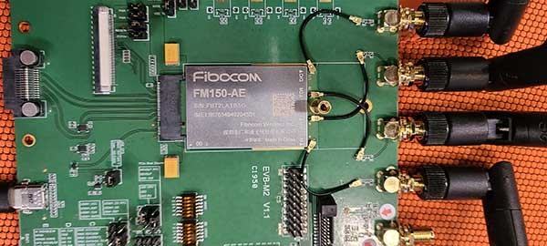
Fibocom’s 5G modules FG150 and FM150 have completed the first data call and end-to-end data transmission services under China Mobile’s Standalone-Structured 5G network. The download rate exceeds 100 Mbps.
Fibocom is a leading provider of cellular embedded wireless module solutions for the internet of things (IoT).
Fibocom FG150 and FM150 5G modules are the first 5G modules based on the Qualcomm SDX55 platform to offer the data-transmission services under the SA-structured 5G network in China, Fibocom said. Its IoT wireless modules incorporate GNSS receivers that receive GPS, GLONASS, Galileo and Beidou signals.
See a test video here:
“Wireless modules are essential for communication between IoT terminals and the base stations. As the world’s leading IoT wireless module solution provider, we are proud that our 5G modules have achieved another R&D milestone in the industry,” said Tiger Ying, CEO of Fibocom. “The completion of the first data call under SA-Structured 5G network is a significant step towards realization of all the three 5G features (eMBB, uRLLC, mMTC) in IoT industry and helps our customers to accelerate the large-scale deployment of 5G industry applications.”
The test was run on the Fibocom FM150 5G module with China Mobile’s 5G SIM card under the n41 network frequency band in the Shenzhen Mobile 5G Joint Innovation Center.
The Fibocom FM150 5G module has been successfully registered on the 5G SA network and established the PDU session. In the 5G SA communication process, the establishment of the PDU session is a symbolic link for successful dialing.
Photo: Fibocom
Fibocom FG150 and FM150 5G modules support both 5G SA and NSA network architectures, providing an integrated multi-network solution that is compatible with the global 5G Sub 6 and millimeter-wave bands. Fibocom 5G modules are compatible with both LTE and WCDMA standards, reducing customers’ investment in the early stages of 5G deployment and helping customers to switch their older product lines to 5G product lines quickly.
Fibocom’s 5G modules have global coverage, accelerating scale deployment of the 5G IoT applications. Applications include: 4K/8K video live broadcast, cloud office (ACPC), drone, robot, AR/VR, 5G virtual dress mirror, 5G cloud game, 5G digital signature, 5G wireless gateway, 5G CPE, 5G SD-WAN, smart grid, telemedicine, connected cars, intelligent transportation system, autonomous driving, smart homes and smart cities.
PCTEL has launched its Trooper TRP-20INT platform, featuring models with a purpose-designed footprint to allow seamless installation on the leading 2020 police sports utility vehicles.
Photo: PCTEL
The Trooper TRP-20INT antenna platform supports the high-speed requirements of complex RF communication systems used for critical communications in FirstNet public safety and intelligent transportation systems (ITS).
These antennas feature two 5G elements compatible with leading cellular routers supporting 600-MHz to 6-GHz frequencies. In addition, PCTEL’s proprietary high-rejection multi-GNSS technology is included for high-precision tracking and asset management.
“In order to meet the communication demands of law enforcement, our Trooper TRP-20INT platform was specifically designed for installation on the raised ridges of police vehicle roofs. This method makes installation easier and optimizes RF performance,” said Rishi Bharadwaj, PCTEL’s chief operating officer.
“PCTEL brings strong RF and mechanical design capabilities to develop high-performance antenna systems for deployments in harsh environments in mission critical applications,” added Bharadwaj.
PCTEL also announced its new and improved PCTWSLMR-2 full-spectrum LMR mobile antenna, designed to support the leading OEM multi-band land mobile radios that enable interoperability among emergency management and response personnel. The new antenna incorporates a strong and ultra-flexible spring structure designed for maximum impact shock absorption, providing solid installation integrity even in low overhead-clearance situations.
PCTEL will showcase its new antenna platforms at IWCE, Aug. 24-28, at the Las Vegas Convention Center, Las Vegas, Nevada, booth 1215. Contact PCTEL for more details on product specifications and availability.
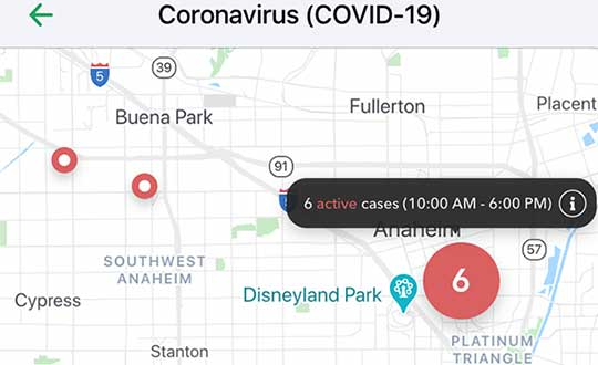
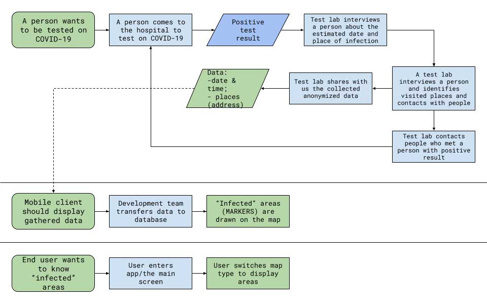
Vesedia Mobile Technologies is offering to deploy its location platform to help control the COVID-19 pandemic through tracking and dissemination of information about “at risk” infection areas and places, and times when they were known to have infection — a process referred to as contact tracing.
Vesedia is a technology startup with a suite of mobile apps for children and family safety based on a location-sharing platform and location-tracking artificial intelligence (AI).
“The platform would warn people that passed through these places at matching times,” explained Ruslan Shalaev, co-founder and team leader, Vesedia. Shalaev developed a popular app for family safety: Safely – Family Location; and serves as a lead research on user-location monitoring AI in an academic partnership with Binghamton University and Lviv National University.
The Safely – Family Location app could be used to disseminate data on infection areas, and access to the API would be provided for other application developers and sites, Shalaev said.
The platform would be applicable after the initial pandemic is contained. “It would help with restarting the economy and resuming normal business operations by providing a mechanism to track, control and suppress new outbreaks,” Shalaev said.
Data Sources
Under the plan, people that test positive to COVID-19 would be asked to provide information about public places they visited in the preceding days, and at what times. Individuals that provide the information can confirm that it’s accurate from their phone location history.
The information would be anonymized by healthcare officials, and entered into a database that would be publicly accessible via a website and mobile app.
Image: Vesedia
Mobile App
The mobile app aspect is especially valuable from information dissemination standpoint, because other people in “at risk” areas can receive automated alerts to self-quarantine and get tested based on their device location history.
The app is ready and available for download in Google Play and Apple App Store.
Image: Vesedia
Image: Vesedia
Workflow diagram
Workflow diagram. (Image: Vesedia)
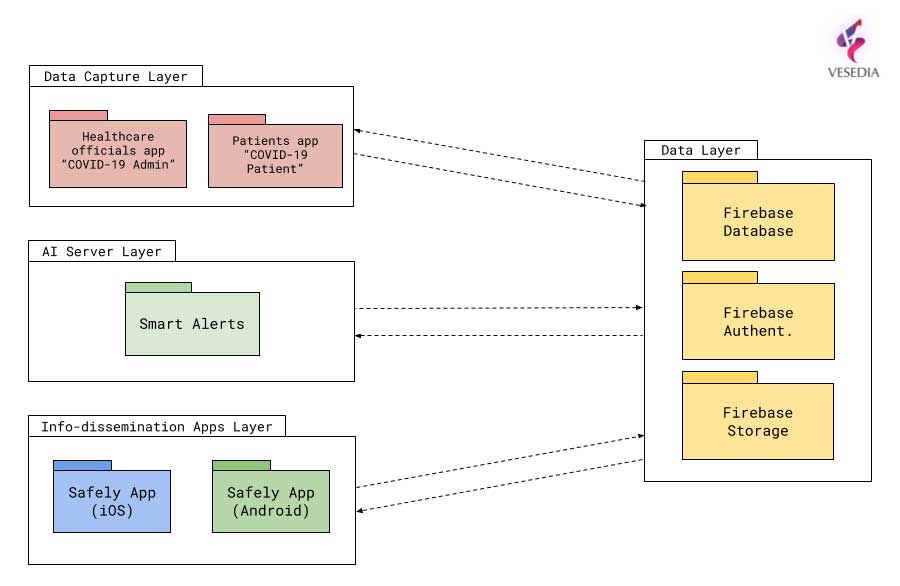
System architecture
System architecture. (Image: Vesedia)
Approach validity
The approach has been successfully applied in Singapore, but without active alerts, with dissemination of information being done manually. The Singapore government was able to contain the virus without shutting down businesses, schools, public transit and restaurants.
Vesedia location apps
Vesedia is a tech startup founded in 2016 by SUNY Binghamton Computer Science graduates. It developed SmartAI location tracking and sharing platform. Its apps include Safely – Family Location, Virtual Nanny, MeetCity – Live Events, Blind Date, Sponter – Social Network in partnership with Lviv National University and Binghamton University. The apps are available for download in the Google Play and Apple App stores.
Vesedia research on “Location-Based Behavioral Patterns Modeling” was published at Institute of Electrical and Electronics Engineers – Intelligent Data Acquisition and Advanced Computing Systems (IEEE/IDAACS) conference in Metz, France in 2019.
Optical Zonu has introduced the ZonuSkyShot GPS tester, designed for quick testing during the critical installation phase of an antenna at a new site build or small cell integration.
The compact tester is designed for integrating one of Optical Zonu’s GPS solutions, but is equally capable of working as a neutral testing device.
Fig. 1. Screenshot of ZonuSkyshot software output. (Screenshot: Optical Zonu)
The ZonuSkyShot is a compact GPS receiver that detects the presence of a GPS signal, indicated on the top-panel LED. The receiver can be accessed at the USB port on the base unit, allowing the user to see the available satellites by using the app provided with the system and available at the Optical Zonu website.
The receiver can simultaneously track up to 16 satellites while searching for new ones. Because of this, a problem can be found and mitigated when a GPS antenna is installed, rather than when hardware is being integrating further down the line. Close-out of projects can be indicated with with screenshots of satellite visibility via the micro-USB port to a laptop.
The app provides:
RF GPS signal presence
GPS antenna functionality
Optical transmitter functionality
Fiber connectivity
Optical receiver functionality
Pre-orders are now being accepted for the kit, which includes the handheld device with power supply, carrying case, jumpers and SMA cable.
Image: ChakisAtelier / iStock /Getty Images Plus /Getty Images
By Eric Colard
Head of Emerging Products, Frequency & Time Systems
Microchip Technology
Mobile operators are investing heavily in the deployment of LTE-Advanced and 5G networks that will transform cellular communications and connectivity.
They face big risks, though: the high-performance mobile services delivered over these networks are extremely dependent on precise time from GPS and other similar regional constellations broadly known as GNSS so they can synchronize radios, enable new applications and minimize interference.
If GPS/GNSS becomes unavailable due to jamming, spoofing, failures or other events, the resulting service disruption would have a catastrophic impact on system performance.
Just like the energy grid is extremely vulnerable to climate, heat, winds and dry vegetation that can lead to fires on a large scale as seen in California recently, 5G networks are vulnerable to disruptions in the distribution of precise time that can lead to total systems outage.
New technologies enable mobile operators to protect their networks from these threats. These technologies make use of existing deployments while creating new architectures for distributing very high-precision time over long distances. They minimize additional costs while offering the necessary performance to meet the demanding requirements of 5G.
Technology landscape
The latest LTE-Advanced and 5G mobile networks bring tremendous capacity and bandwidth gains that are being used to deliver new services to consumers, industries, cities and specific market segments. From high-bandwidth video delivery for smartphones to autonomous vehicles, smart cities and the internet of things (IoT) for smart factories, these new services all rely on the synchronization of numerous sensors, base stations and other devices.
Accomplishing this requires the delivery of very precise time over long distances. Without it, mobile operators cannot maximize deployment investments by minimizing disruptions and risk.
They also must devise plans they can leverage in case of GPS/GNSS malfunction. At the same time, they need to take advantage of optical networks and other existing infrastructure so that they don’t require expensive new investment in dark fiber.
Photo: iStock.com/NicoElNino
Meeting stringent requirements
Standards bodies have defined stringent requirements for precise time and synchronization such as Prime Reference Time Clock (PRTC), which includes 100-nanosecond (ns) PRTC Class A (PRTC-A), 40-ns PRTC Class B (PRTC-B) and 30-ns enhanced PRTC (ePRTC) performance specifications.
To meet these requirements, a high-quality source of time is an absolute must and a very resilient, efficient and performant distribution mechanism is required to transport time from the source to the various devices consuming time (for example, base stations, sensors and vehicles).
The problem with relying on GPS/GNSS for meeting these requirements is that its deployment can be expensive given the increasing densification of endpoints. There is also a technical vulnerability associated with GNSS receivers located at cell sites.
If the GNSS receiver cannot track satellites properly for whatever reason, the radio must be removed from service quickly to avoid interference issues due to the short holdover period of the oscillator technologies used in the radios. Because of these technical and financial considerations, operators are very motivated to find solutions where GNSS dependency is reduced or even eliminated at many locations.
Another set of considerations for operators includes:
the distribution of time from the source to the endpoints using the network;
the network nodes; and
the various synchronization capabilities these network nodes can support.
Typically, a precision time protocol (PTP) grandmaster is located at the beginning of the timing chain and complies with 100ns PRTC-A or 40-ns PRTC-B so it can deliver precise time to the end of the chain within +/-1.5 microseconds. The network nodes on the path typically embed a Time Boundary Clock (T-BC) capability that meets either Class A (50-ns) or Class B (25-ns).
A new type of time-distribution architecture is needed to address these requirements and considerations so operators can protect their mobile network against GNSS disruption and distribute precise time over long distances for national coverage. This architecture must also deliver the necessary performance to meet end-to-end budgets for 5G needs.
A different time-distribution architecture
There are multiple capabilities a high-precision time-distribution architecture should feature so that operators can most effectively mitigate GPS/GNSS vulnerabilities and solve other challenges in their 5G networks. The architecture should:
leverage the existing optical network (thus avoiding high cost dark fiber expenses)
use a dedicated lambda in order to transport time in the most rapid manner
protect, to the utmost level, a redundant source of time that meets the highest, 30ns ePRTC performance and uses a combination of Cesium and GNSS as the source of time
have two directions for the flow of time (East and West) so that a redundant path can be leveraged in case of any issues along the way from source to endpoint
have a chain of high-precision boundary clocks (HP BCs) that can meet the highest level of performance defined by today’s standards (T-BC Class D 5ns)
A multi-domain architecture of this type offers the redundant, sub-microsecond end-to-end timing capabilities that are required to affordably deliver the high performance, 5-nanosecond per node distribution of precise time over hundreds of miles.
An example of this type of solution is Microchip’s TimeProvider 4100, which can be configured as either an ePRTC at the source of the timing chain with PRTC-A and PRTC-B time-delivery capabilities to various end nodes, or an HP BC on the optical network path.
This type of product can also be configured for application-specific requirements, end to end, with up to nanosecond precision time-delivery capabilities over long distance.
Assuring precise timing
The success of a coming generation of high-performance mobile services will depend on how well operators address today’s critical GPS/GNSS vulnerabilities. Jamming, spoofing, failures or other events can disrupt the precise GPS/GNSS timing that 5G networks need for synchronizing radios, enabling applications and minimizing interference.
The latest high-precision time-distribution architectures mitigate these risks with minimal additional cost and give operators the performance they need to support demanding new 5G services ranging from IoT-based applications to receiving high-bandwidth video on smartphones.
Microchip has released version 2.1 for its TimeProvider 4100 timing grandmaster.
Eric Colard leads product line management for Microchip’s TimeProvider 4100 and Integrated GNSS Master solutions for the telecom, utility and other industries. Colard’s leadership includes product definition, customer interaction, outbound promotions and business development.
He has held successive technical and leadership roles at technology companies in the U.S. and Europe. He began his career as an engineer in the networking arena on X.25, frame relay and other protocols at companies including Alcatel and Cap Sesa Telecom. He later held successive product management and business development leadership roles in networking, security, and other areas at Novell, Tumbleweed, FaceTime and Vernier Networks.
As the industry rapidly progressed, Colard increasingly became involved in wireless data compression and TCP/IP optimization. In 2007 he joined Symmetricom and architected and built the SyncWorld ecosystem with partners Alcatel-Lucent, Ericsson, Nokia Siemens and Cisco. Through acquisition Symmetricom became part of Microsemi, which today is part of Microchip.
Colard holds bachelor of science and master of science degrees in computer science, both from Ecole Nationale Superieure des Telecommunications (now Telecom ParisTech) in Paris, France. He is a member of the Metro Ethernet Forum (MEF), Open Compute, Telecom Infra Project and Small Cell Forum. He has received an award for his industry contributions from the Small Cell Forum.
Precise timing grandmaster with gateway clock and high-performance boundary clock enhances 5G mobile network phase protection
To help 5G mobile providers, cable operators and utility providers ensure phase delivery, protection and synchronization even when GNSS is offline, jammed or spoofed, Microchip Technology Inc. has released software version 2.1 for its TimeProvider 4100 precision timing grandmaster.
TimeProvider 4100 is a 1588 grandmaster including support for the latest ITU-T G.8275.1 and G.8275.2 1588 phase profiles, complemented by extensive port fan-out for PTP, Network Time Protocol (NTP), SyncE, and E1/T1.
Software release 2.1 builds on earlier versions by adding key software enhancements providing a virtual Primary Reference Time Clock (vPRTC). Virtual PRTC provides the ability to design a redundant precise time distribution architecture for phase protection over an optical network.
Until recently the main source of precise time has been GPS and other constellations that comprise GNSS. Deployment of GNSS, however, can be costly for service providers given the costs associated with upgrading to GNSS-capable receivers and antennae as well as increasing densification of end points.
As a result, telecom, cable and utility operators deploying vPRTC benefit from solutions where GNSS dependency is reduced or eliminated. Following are key features of the new vPRTC functionality:
Leverages the existing optical network, avoiding high-cost dark fiber expenses
Uses a dedicated lambda to transport time precisely and securely
Provides a high-performance, redundant source of time through enhanced PRTC (ITU-T G.8272.1)
Allows bidirectional, precise time flows (east and west)
Chains together high-precision, multi-domain, high-performance boundary clocks that meet today’s standards (T-BC Class D, as defined by ITU-T G.8273.2)
Microchip’s vPRTC multi-domain architecture is a cost-effective solution providing a high-performance, redundant, sub-5 nanosecond distribution of precise time over regional and national networks.
In addition, Release 2.1 introduces Network Time Protocol daemon (NTPd) with Message Digest (MD5) security algorithm.
TimeProvider 4100 2.1 meets PRTC-B performance standards (per ITU-T G.8272) and supports 1G and 10G, NTP and PTP in a single form-factor system. TimeProvider 4100 2.1 is available now for both new and already deployed systems.
Verizon will integrate TomTom’s Maps application programming interfaces (API) and software development kits (SDK) into its location-services offering, making it easier for the developer community to build upon and integrate the platform. The developers’ portal is available at developer.tomtom.com. More information from
The agreement is an expansion of the existing TomTom and Verizon agreement, where TomTom provides location-based services to enhance Verizon’s current suite of location-based data, navigation, and intelligence.
“We look forward to continuing to build upon and evolve our product suite with TomTom’s technology,” said Jeff Frantz, executive director, Verizon Location Services. “By expanding our agreement, we are furthering our commitment to providing best-in-breed location technology for Verizon and our customers.”
“We’re determined to make it as easy as possible for developers to have access to our Maps APIs and SDKs so we’re delighted that Verizon is offering TomTom products to their location-services customers,” said Anders Truelsen, managing director, TomTom Enterprise.
5G and HD Maps. In the last quarter of 2019, the companies also announced an innovation project using Verizon 5G Ultra Wideband and TomTom HD Maps to help make intersections safer for emergency vehicles.
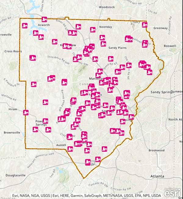
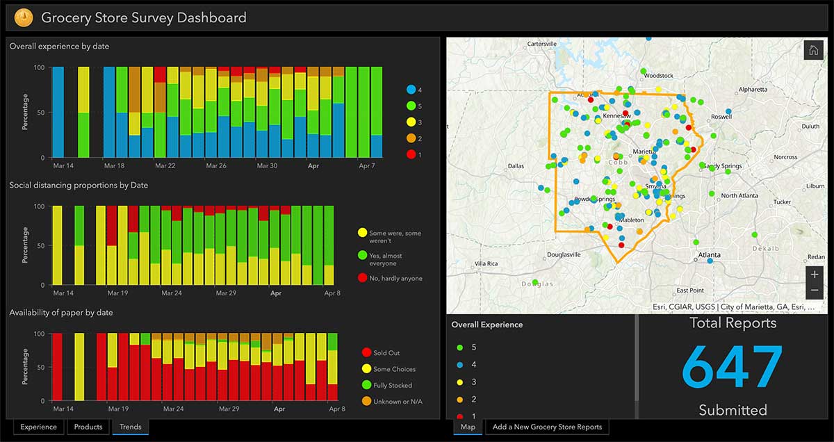
Cobb County, Georgia, is providing its residents with an app that tracks what grocery stores are stocking which essential goods, such as paper products, cleaning items and fresh produce.
The Cobb COVID-19 Grocery Stores and Inventory app gathers input from users, and the data is posted anonymously. Stores can be sorted by distance, senior hours and crowds. Cobb County is a suburb of Atlanta.
The Cobb County Geographic Information System (GIS) department created the app using Esri ArcGIS.