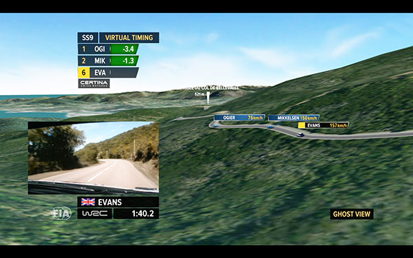
Canal+, a French cable television channel, used Trimaran’s GeoRacing GPS tracking and visualization system to improve live television coverage of the Tour de Corse 2015, the FIA World Rally Championship held on the island of Corsica in October.
Through a combination of GPS data and advanced technologies like virtual timing and ghost visualization, Trimaran’s GeoRacing solution allowed Canal+ to track the motorsport race in real time and better visualize its progression, enhancing the television viewer’s experience. The system dramatically improves the broadcaster’s ability to deliver live audio commentary about the race, giving viewers a race-time comparison of the drivers along with other important stats.
During the Tour de Corse race, Canal+ used multiple cameras with GPS trackers in cars and helicopters, and at the starting, mid-point and finish lines. The GPS tracking system situated on the cameras was provided by AMPVisual TV, a technology partner of Canal+ and Trimaran.
Throughout the race, GPS positioning from each of the cars was sent to the GeoRacing system. Using Trimaran’s solution, Canal+ instantly delivered detailed sports information and statistics, such as speed, timing (retiming for staggered starts) and ranking. This enabled viewers to better understand the progression of the live race.
With the virtual timing capability, Canal+ was able to demonstrate the virtual differences between cars at a precision of 1/10th of a second. Trimaran’s ghost visualization feature provides a 3D representation of the rival positions in real time, creating the feeling that the cars all left the starting line simultaneously.
TomTom has signed a global, multi-year agreement to provide maps and traffic data for the Uber driver app.
TomTom’s advanced map-making technology, combined with its traffic information, will ensure Uber has a seamless navigation experience, accurate arrival times and efficient journeys in more than 300 cities around the world, according to a TomTom news release.
“We are excited to provide Uber with our best-in-class location data,” said Charles Cautley, managing director, Maps and Licensing at TomTom. “TomTom is a truly independent map provider with the platform for the future. With this platform, TomTom is the trusted partner for innovative and future proof location technology for the global automotive and consumer technology industry.”
“We look forward to working with TomTom, a leader in the mapping and navigation space,” said Matt Wyndowe, head of Product Partnerships at Uber. “Their mapping and traffic data will help ensure we continue to provide a great experience for drivers everywhere.”
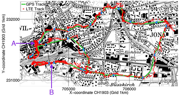
Rover positions obtained with 2D LTE versus GPS track.
Positioning with LTE Signals
An alternative to GNSS in urban canyons can be provided by signals from cellular base stations, particularly new signals from long-term evolution (LTE) networks, since LTE coverage will be high in cities. Wide LTE downlink bandwidth provides good resolution of multipath components, which also assists positioning.
A test used a universal software radio peripheral N210 synchronized to a GPS-locked Rubidium frequency standard. A personal computer stored LTE data samples together with GNSS sentences from a u-blox LEA-6T module. A Matlab-algorithm did the complete post-processing, extracting pseudoranges for the LTE base station and calculating the position solution.
Results of a car driven on an urban route show root-mean-square value of the absolute error using LTE compared to GPS position is 43 meters.
Positioning Using LTE Signals, by Fabian Knutti, Mischa Sabathy, Marco Driusso, Heinz Mathis, and Chris Marshall. Presented at the European Navigation Conference 2015.
Seamless Indoors
Sensor Augmented Indoor Navigation and Positioning, by M. Gemelli and Keith Nicholson, Bosch Sensortec. An overview of technologies that guide us indoors in a seamless and reliable manner, highlighting key requirements for motion and pressure sensing, low-power processing, efficient code design, wireless beaconing and map matching. Fusion software needs new data sources: Bluetooth low-energy, Wi-Fi fingerprinting, magnetic fingerprinting, ultrasound. Presented at ION GNSS+ 2015.
Disturbed Ionosphere
Mitigating satellite motion in GPS monitoring of traveling ionospheric disturbances (TIDs), by R.W. Penney and N.K. Jackson-Booth. Discusses the impact of satellite motion on the use of compact arrays of GPS receivers for estimating the velocity of travelling ionospheric disturbances (TIDs). It is shown that satellite motion has subtle effects upon standard techniques of waveform cross-correlation, or time-difference of arrival (TDOA), which can easily lead to spurious TID velocity estimates. In Radio Science, an AGU journal.
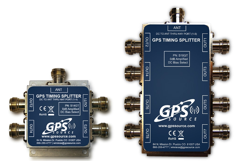
GPS Soure is offering the S14GT & S18GT splitters for small cell networks and distributed antenna systems (PRNewsFoto/GPS Source, Inc.)
GPS Source has released of a line of GPS/GNSS splitters created for the small-cell wireless and distributed antenna system markets. Specifically designed for the L-band frequency, they can eliminate the cost of multiple antennas and long cable runs in wireless installations.
With four or eight outputs, the new line of GPS/GNSS splitters make it possible to use a single GPS referencing antenna and cable arrangement for multiple synchronized systems. The splitters are available at a low price point and include features such as DC bias select and amplification.
GPS Source RF signal splitters typically operate in conjunction with an active GPS antenna (a GPS antenna that includes an integrated low noise amplifier). Consequently, a GPS RF signal splitter must have provisions for managing the DC voltage to the active GPS antenna. The S14GT and S18GT will power an external GPS antenna from any of the RF outputs. A “hunt-and-pick” circuit is used to select only one DC input for power should more than one source be connected. Designed for redundancy, if the selected DC bias input should fail, the DC bias will automatically switch to another DC input to ensure an uninterrupted power supply to the active antenna.
“Distributed antenna systems allow for easy system growth in size and scope of application, whether the system needs to scale to reach new service areas or add bandwidth and capacity,” said Robert Horton of GPS Source. ” This growth has led to a strong demand for cost effective solutions that support GPS synchronization, an area where we are specialists. GPS Source brings leading-edge technologies and addresses major GPS/GNSS challenges faced by carriers and system integrators.”
The S14GT and S18GT are in production and will be available January 2016. A CE Mark approval from the European Notified Body for these two devices will be available afterward.
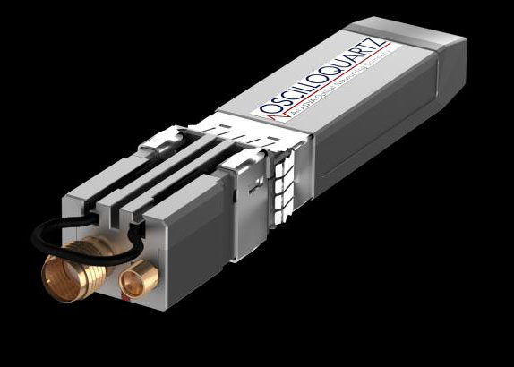
Oscilloquartz, an ADVA Optical Networking company, has launched its OSA 5401 Syncplug, an accurate and efficient small-form-factor pluggable grandmaster clock and GNSS receiver.
The device has a small footprint and compact design. It complements the existing portfolio of Oscilloquartz products, driving precise IEEE 1588v2 Precision Time Protocol (PTP) frequency and phase synchronization as well as Synchronous Ethernet deeper into access networks, including radio access and small cell networks.
With its miniature form factor and low-touch provisioning, the new synchronization solution can be deployed in space-restrictive environments. It operates at low cost, consumes minimal energy and requires no additional power source or real estate, Oscilloquartz said.
The OSA 5401 Syncplug supports the creation of a new time distribution architecture to meet the stringent phase-synchronization requirements of today’s access networks, the company said.
“In terms of efficiency, precision and density of design, our OSA 5401 Syncplug miniature grandmaster is a major development for our industry,” said Kenneth Hann, senior director, R&D, Oscilloquartz. “It’s possibly the world’s smallest grandmaster clock and yet it generates phenomenally precise PTP frequency and phase synchronization for radio access and small cell networks. Now network operators have a cost-effective migration path for deploying robust phase and frequency synchronization deeper into access networks. Our OSA 5401 Syncplug integrates with existing network elements and its small form factor and rich feature set enable a versatile range of deployment options for enhanced synchronization network performance. Its timing-optimized, dual-frequency GNSS receiver achieves excellent performance even in urban canyons where small-cell deployments are often made and it can also work with a single satellite.”
The OSA 5401 Syncplug is the first new product to be jointly engineered by Oscilloquartz and members of the recently acquired Time4 Systems. It easily conforms to all relevant PTP telecom profiles and, when locked to global navigation systems, meets the stringent requirements of G.8272 and G.811 specifications. The device functions as a Synchronous Ethernet source, GNSS receiver and a grandmaster clock. It can support both Layer 2 and Layer 3 PTP transport and is capable of unicasting and multicasting simultaneously. Advanced design and network redundancy techniques provide resiliency against local GNSS jamming. It also boasts an impressively wide operational temperature range of -40 to 85 Celsius. But the key benefits that the OSA 5401 Syncplug provides are space and energy efficiency for significant savings in installation and engineering costs. It also fully complies with multi-source agreements for total interoperability.
“An enormous amount of expertise and passion has gone into designing this device. It’s been driven by our strategic understanding of what’s most needed in the synchronization space,” said Gil Biran, general manager, Oscilloquartz.
“This first member of our miniature sync product family has already won great feedback from major mobile operators. What makes our ultra-compact OSA 5401 Syncplug so special is that it combines small size with high performance,” Biran said. “Make no mistake, there’s a vast amount of advanced functionality squeezed into this device. That’s what enables it to deliver highly accurate timing distribution with the smallest available footprint. This level of agility and efficiency creates a new range of solutions for service providers to deploy phase synchronization even in the most difficult network scenarios. There’s no doubt that this is an exciting time for network synchronization technology and this new product will extend our position in the market as a one-stop shop for all synchronization solutions. The new generation of mobile networks demands more small cells and a higher density of radio heads and we’re addressing this challenge in the most energy-efficient and cost-effective way possible.”
Watch ADVA Optical Networking’s latest video on assisted partial timing support for more information.
Trimble has introduced a new grandmaster clock to address the synchronization needs of the fast growing next-generation LTE-Advanced and small cell network market. The Thunderbolt PTP Grandmaster Clock (GC), coming in the first quarter of 2016, was introduced at the ITSF 2015 Time and Synchronization in Telecoms Conference, held in Edinburgh, UK, Nov. 2-5.
Trimble said it value-engineered the industry-standard grandmaster clock, focusing on the features required in next-generation networks, including dual gigabit Ethernet ports and a small form-factor pluggable module port for optical connections. Its low price point enables network architects to move the timing source from the core to the edge of the network, enabling higher phase and frequency precision at the Precision Time Protocol (PTP) clients.
“Trimble entered this market to expand on our success in GNSS timing solutions for telecom networks,” said Karen Guldan, general manager of Trimble’s Time & Frequency Division. “The design and development of the GC focused on creating an optimized solution for network providers — at a price point of less than $2,000, it is intended to be a game-changer in small-cell network design. The GC’s features provide superior value to service providers.”
With flexible network interface protocols and easy integration, Trimble optimized the GC to deliver precise frequency and phase synchronization signals for LTE-Advanced and small cell networks supporting IEEE 1588 PTP, Network Time Protocol (NTP) and Synchronous Ethernet simultaneously. The GC supports up to 250 simultaneous PTP clients and 5,000 NTP transactions per second, and is designed for small- and medium-scale deployment.
With a small form factor of half rack 1RU, users may deploy the Trimble GC either indoors or outdoors. In a server room, the Trimble GC deploys in a side-by-side configuration to provide timing redundancy. For outdoor applications, the Trimble GMC also features an extended operating temperature range for use in non-typical networking environments such as a telecom cabinet. The Trimble GC configures for AC and DC power.
The GC was designed to provide continuous availability of traceable time. The GC includes an embedded, multi-GNSS (GPS, GLONASS, BeiDou and Galileo-ready) receiver to generate precise 10MHz and pulse per second outputs. Utilizing the latest in GNSS technology combined with a precision oscillator, the GC provides better than 3 microsecond phase holdover over a 24-hour period.
The Trimble Thunderbolt PTP Grandmaster Clock is expected to be available in the first quarter of 2016.
With the service, media players display a content loop with information specific to the vicinity of the vehicle.
MediaSignage has released GPS-powered, location-based services (LBS) for digital signage. The tool provides specific geo-targeting of advertising campaigns based on the location of the screen.
The GPS-enabled location targeting works well for buses, taxis and trains, because advertisers can more easily target their digital signage content based on a targeted geographic radius, MediaSignage said in a press release.
For instance, a taxicab may provide digital signage behind the headrest and allow local advertisers to target messages to patrons that ride within the cab. When a moving car, bus or train enters the desired radius (such as close to a specific restaurant or local venue), the installed media player displays a new content loop with information specific to the vicinity. Once the media player moves out of that vicinity, the original content loop resumes.
MediaSignage has designed the tool to be simple and affordable, enabling any business owner to have their message presented in a matter of a few minutes. Users can log in to StudioLite, set the radius on a map, and set the priority duration for each content resource that is to be displayed. Users can set radius location information for several desired areas within a geographic footprint.
When users combine the power of GPS tracking into moving digital signage, the ability to target for advertising purposes becomes extremely powerful, MediaSignage said. Placing local advertisements in taxi, bus, train and even Uber cars provides a powerful tool for selling ads and targeting customers.
“We are extremely pleased and excited by this latest feature implementation within our system,” said MediaSignage president Nate Nead. “It provides an additional value-adding tool for digital signage business owners and operators, allowing them to better monetize their display screens in a host of different and non-traditional environments. We hope our users will take full advantage of the new features and that the features will provide a profit-enhancing tool for their businesses.”
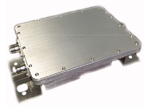
The new PXC021-V2 by Filtronic is a wideband cellular + GPS low-loss splitter/combiner.
Designed for repeater/DAS applications, the PXC021-V2 provides GPS L1 and L2 frequency coverage and wideband cellular frequency coverage (618-960 MHz and 1695-2690 MHz). It has low loss (≤ 0.30 dB Cellular and ≤ 0.70 dB GPS) and excellent cellular to GPS isolation (≥ 55 dB).
The L1/L2 Channel Absolute Group Delay is 20 nS maximum (17 nS typical), and the variation is 4 nS p-p maximum over the L1/L2 bandwidth. The
German research organization Fraunhofer Gesellschaft has developed and presented an over-the-air (OTA) wave-field synthesis system for test and certification of GNSS receivers. The testing platform is at its Fraunhofer IIS Facility for Over the Air Research and Testing (FORTE) in Ilmenau, Germany.
The innovative and complex OTA test system is based on hardware and software solutions from IZT GmbH, such as powerful RF receivers and high-performance signal generators.
The demonstrated setup to test GNSS receivers represents a new approach that — in contrast to conventional conducted and open-field tests — realistically emulates real-world scenarios under controllable and repeatable conditions, enabling the realistic comparison of receivers and algorithms. The OTA test system is cost-effective, flexible and scalable.
The newest generations of mobile communication systems employ multiple antennas for transmission and reception, such as LTE, LTE-A, WIMAX and Wireless LAN. Multiple Input Multiple Output (MIMO) OTA test systems are typically deployed for certification, performance testing and product evaluation of broadband wireless devices. The related devices have to be tested in their related environments.
In contrast to mobile phones, GNSS receivers are extremely susceptible to all types of interference. Hence, the goal was to develop a new testing method for interference robustness of GNSS receivers.
The OTA Test Approach
The OTA test laboratory comprises a satellite signal emulator (Spirent) used as signal source, several OTA channel emulators used for wave-field synthesis that are able to emulate any electromagnetic environment in an anechoic chamber, and several OTA illumination antennas. The OTA channel emulators from IZT GmbH support 8 input and 32 phase coherent output channels (up to 256 logical channels) in the frequency range of 1 to 6 GHz, and provide the output signals to the OTA illumination antennas. Note that the final extension of the system based on the IZT components will have 12 x 32 channels.
The unique test environment developed at FORTE together with IZT GmbH excels in its great flexibility regarding possible applications in communications technology. The new OTA emulation approach enables realistic radio channel emulation taking into consideration multipath propagation, multi-frequency, and multi-user scenarios.
The OTA system supports emulation of complex channel impulse responses of nearly unlimited length. Besides GNSS equipment, the test system can be applied for LTE and Cognitive Radio (CR), sensor networks (including energy networks and smart metering) or car-to-car and car-to-infrastructure communications.
The Innovationszentrum für Telekommunikationstechnik GmbH IZT is a spin-off of the Fraunhofer-Gesellschaft, Germany’s leading institution for applied research. Founded in 1997 in Erlangen, the company emanated from the Fraunhofer Institute for Integrated Circuits (IIS). It specializes in advanced digital signal processing and field programmable gate array (FPGA) designs in combination with high-frequency and microwave technology.
Czech automaker ŠKODA is offering a tablet game that gives kids in the backseat the opportunity to follow along as their parent drives.
With the ŠKODA LittleDriver app, children can imitate the driver’s actions using real data from the car. The app makes use of ŠKODA’s SmartGate interface, which uses Wi-Fi to send vehicle data to a connected device.
LittleDriver is fully interactive: children can copy the actions of the real driver and collect points when they are correct. Steering, acceleration, turning, braking — everything that the driver does, the player can imitate on a tablet in real time. Speed, fuel level, brake status and oil pressure are also displayed.
At the end of the game, points earned can be used to design a virtual ŠKODA, which can be configured individually in the app. The ŠKODA LittleDriver app is available on the Apple and Android app stores, and is aimed at ages 9–12.
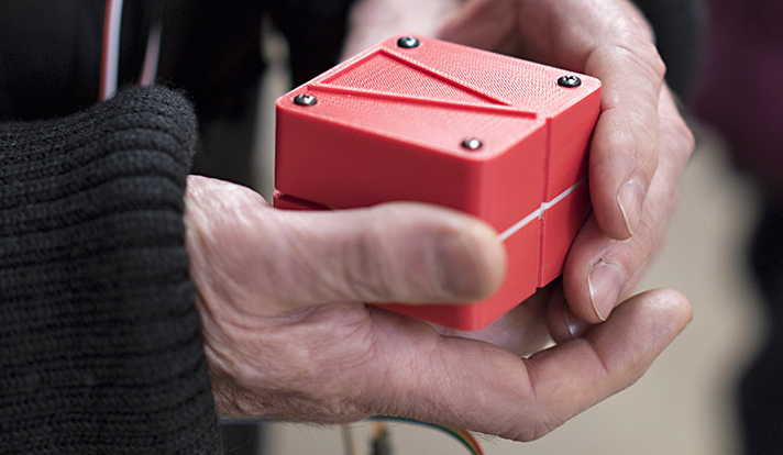
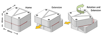
A handheld GPS device uses touch to help you determine where to walk. Made with a 3D printer, the cube-shaped “Animotus” was designed with the visually impaired in mind, reports YaleNews.
Designed by Adam Spiers, a Yale University post-doctoral associate in mechanical engineering, the Animotus is designed in layers, with the receiver in the middle. The top layer revolves to show what direction to walk, extending to indicate distance.
When it stops twisting and returns to its cube shape, you’ve reached your destination. It can be programmed wirelessly on a computer or a smartphone.
Spiers said he chose touch for guidance over sound because of the many aural distractions.
(Diagram: YaleNews)
The Animotus was tested in London in an immersive production of a play based on the novella Flatland, about a two-dimensional world. Using the Animotus, the audience was guided through the church to uncover the plot. When the Animotus signaled participants to stop, narrative and sound effects took over. The performing company includes sight-impaired members.
The Animotus was demonstrated at the World Haptics Conference in June at Northwestern University and received “quite a bit” of interest, Spiers said.
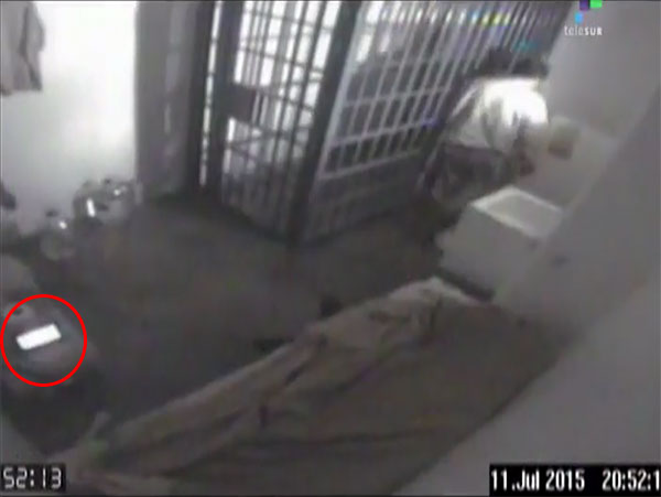
Joaquin “El Chapo” Guzman’s accomplices knew where the world’s most wanted and powerful drug lord was at all times because he had television in his cell that has a GPS tracking device inside of it, according to the Mexican newspaper La Jornada.
Prison officials seized all electronic devices from all the cells inside the maximum security jail in Toluca after El Chapo’s escape through a mile-long tunnel on July 11.
The GPS device would explain why El Chapo’s associates were able to precisely excavate a tunnel into his cell.
The red circle shows the television with the GPS tracker inside.