A huge network of iBeacon (Apple)and Eddystone (Google) devices has emerged in China, consisting of 110,000 units run and managed by Sensoro.
The network spans 25 movie theatres, 16 airports, 39 high-end retail stores, 40 major tourist destinations, 200 universities, 260 high-speed trains, 1,500 Pizza Huts and 2,100 Chow Tai Fook (CTF) jewelry stores, among other locations.
Sensoro was founded in July 2013 through the Microsoft Ventures Accelerator program for startups. Its goal is to construct a data network that integrates intelligent sensors (in this case, Bluetooth) and the mobile Internet.
During the 2015 Chinese New Year in February, traffic at beacon-outfitted locations reached the hundreds of millions, according to a Sensoro blog. CTF’s use of the iBeacons generated 11 million dollars in revenue with a coupon conversion rate as high as 63 percent, far surpassing expectations, according to CTF’s 2015 earnings report. CTF has since deployed beacons in all 2,100 of its mainland China retail stores.
Data gathered by Sensoro will allow retailers to target customers with increasing accuracy the longer the network is in use.
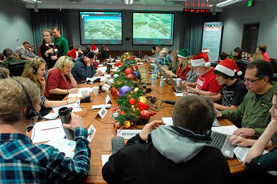
NORAD employees volunteer for Santa tracking and response duty.
NORAD is celebrating the 60th Anniversary of tracking Santa’s yuletide journey through an interactive website, smartphone apps and social media.
NORAD, the North American Aerospace Defense Command, is based in Colorado Springs.
The NORAD TracksSanta website, launched Dec. 1, features Santa’s North Pole Village, which includes a holiday countdown, games, activities and more. The website is available in eight languages: English, French, Spanish, German, Italian, Japanese, Portuguese and Chinese.
Official NORAD Tracks Santa apps are also available in the Windows, Apple and Google Play stores, so parents and children can countdown the days until Santa’s launch on their smartphones and tablets. Tracking opportunities are also offered on Facebook, Twitter, YouTube and Google+. Santa followers just need to type “@noradsanta” into each search engine to get started.
Also new this year, the website features the NORAD Headquarters in North Pole Village, and highlights of the program over the past 60 years.
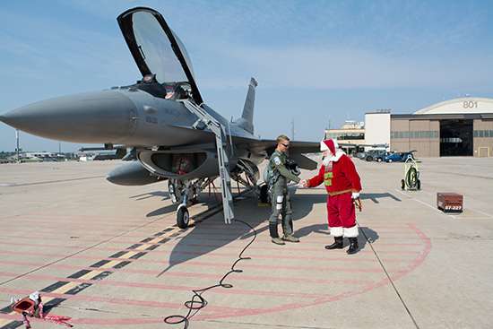
Santa visits NORAD.
Starting at 12:01 a.m. MST (2:01 a.m. EST) on Dec. 24, website visitors can watch Santa make preparations for his flight. NORAD’s “Santa Cams” will stream videos on the website as Santa makes his way over various locations. Then, at 4 a.m. MST (6 a.m. EST), trackers worldwide can speak with a live phone operator to inquire as to Santa’s whereabouts by dialing the toll-free number 1-877-Hi-NORAD (1-877-446-6723) or by sending an email to [email protected].
Any time on Dec. 24, Windows Phone users can ask Cortana for Santa’s location, and OnStar subscribers can press the OnStar button in their vehicles to locate Santa.
NORAD Tracks Santa is a global experience, delighting generations of families everywhere. This is due, in large part, to the efforts and services of numerous program contributors.
It all started in 1955 when a local media advertisement directed children to call Santa — only the number was misprinted. Instead of reaching Santa, the phone rang through to the crew commander on duty at the Continental Air Defense Command Operations Center, the predecessor to NORAD. Thus began the tradition, which NORAD has carried on since the agency was created in 1958.
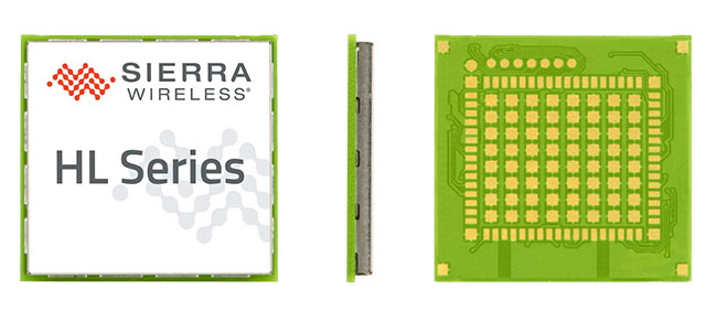
Maestro Wireless Solutions Limited, a provider of tracking devices for Internet of Things (IoT) applications globally, has announced its first LTE Cat-1 tracker based on the AirPrime HL Series from Sierra Wireless.
Maestro’s newest tracker, the ruggedized MT-44, provides fleet and asset tracking capabilities in harsh mobile environments using the LTE Cat-1 module with maximum data rates of 10 Mbps downlink and 5 Mbps uplink.
The Maestro MT-40 Series is a compact range of rugged micro-trackers for the vehicle tracking market.
“We have been integrating Sierra Wireless modules into our products for more than 15 years and we have always trusted the company to deliver on leading edge cellular technologies that improve product performance,” said Xavier Dupont, chief executive officer of Maestro. “The HL Series provides us with a single footprint for 2G and 3G global coverage and the LTE Cat-1 module is utilizing the same compact design in our newest tracker.”
“Today, we are seeing strong interest in our LTE Cat-1 embedded modules optimized for lower bandwidth and power requirements,” said Dan Schieler, senior vice president, OEM Solutions for Sierra Wireless. “We are pleased to have Maestro deploying our latest LTE technology in their tracking devices. The HL Series Cat-1 module provides the next step in the evolution for our customers, as service providers are continuing to transition their networks to LTE technology.”
The HL Series uses the CF3 form factor from Sierra Wireless that is footprint-compatible across product lines and network technologies, and is fully interchangeable with future versions of the modules, including LTE-M variants when they become available.
LTE-M is a Low-Power Wide Area (LPWA) technology that will provide a highly efficient cellular option with lower radio-frequency complexity, significantly reduced power consumption (up to 10 years of service on a single AA battery), better in-building signal penetration and lower costs. Sierra Wireless is an active contributor to the LTE-M standard definition process within the 3GPP and has committed to launching compatible modules timed with network deployments, expected to begin in 2017.
The LTE Cat-1 modules from Sierra Wireless will be commercially available in January 2016 on the HL Series.
Huawei has licensed the InvenSense Positioning Library (IPL) software sensor-assisted positioning technology for incorporation into the Kirin 950 mobile application processor platforms by HiSilicon.
InvenSense is a provider of micro-electro-mechanical (MEMS) sensor platforms. The recently launched Huawei Mate 8 smartphone is the first model to incorporate the HiSilicon and IPL technology.
IPL improves smartphone GNSS-only implementations by providing more continuous and accurate navigation in areas with poor GNSS signal quality. The IPL solution delivers sensor-enhanced positioning providing a high-availability, high-accuracy turn-by-turn navigation user experience to HiSilicon mobile platforms and mobile application developers.
Through this collaboration, InvenSense and HiSilicon will make continuous improvements to IPL and the overall location subsystem to provide the best possible navigation experience to Huawei’s customers.
The Huawei Mate 8 smartphone is the first model to incorporate Invensense MEMS technology.
The combination of sensor positioning with GNSS enhances navigation user experience by eliminating “GPS Signal Lost” warnings and unnecessary re-routings in map applications due to GNSS multipath errors. IPL uses complex algorithms that take sensor data from the mobile device gyroscope, accelerometer, magnetometer and barometric pressure sensors to generate an inertial navigation system (INS) that tracks the position change of a vehicle or pedestrian.
IPL then combines the INS with GNSS to provide always-available and more accurate location data when GNSS is inaccurate or unavailable, such as in deep urban canyons with tall buildings or in tunnels and parking garages. IPL operates in any physical orientation allowing the user to freely move the phone in the vehicle during active navigation sessions.
“Today’s consumers are increasingly using smartphones for turn-by-turn navigation in vehicles, creating a strong need for a higher quality user experience that decreases the occurrence of confusing or stressful re-routes and GPS lost signal messages,” said Eitan Medina, vice president marketing and product management at InvenSense. “We are pleased that HiSilicon, a market leader in end-to-end chipsets and solutions, has chosen our IPL technology for integration into its mobile platforms.”
IPL is available now for smartphones using Android, iOS, Windows and general Linux operating systems.
Hexagon AB has entered a strategic partnership with Huawei, an information and communications technology (ICT) company, to deliver smart city solutions.
With most of the world’s population living in cities, safety and infrastructure challenges are at an all-time high. Hexagon and Huawei are working together to meet this global challenge by integrating Huawei’s communications hardware with Hexagon’s safety and infrastructure software solutions.
The combined solution improves inter-agency collaboration and leverages big data analytics to better predict, prepare for, and respond to urban area challenges.
Safety is a primary focus of the combined solution, offering cities connected command centers with integrated systems that maximize efficiencies in all preparedness and response areas. Huawei’s contributions include technologies from its Safe City portfolio such as high-definition video surveillance, broadband trunking and IP-based conference calling systems. Hexagon’s emergency response, utilities management and transportation software solution portfolio, which includes computer-aided dispatch, will provide the visibility and decision-support backbone to enable customers to think and act more nimbly.
“Huawei’s technologies, expertise and global coverage, especially in emerging market areas, nicely complement our ability to deliver smart city solutions to law enforcement, government, security personnel and other public service agencies around the world,” said Ola Rollén, Hexagon president and CEO.
“Safety, including efficient response to crisis management, will continue to be a key challenge for urban management, especially in developing economies that are stimulating population movement into these areas,” said Yan Lida, president of Huawei Enterprise Business Group. “Together with Hexagon, the global authority on safety and infrastructure solutions, our extensive ICT technologies that help architect safe city infrastructure will help make societies safer.”
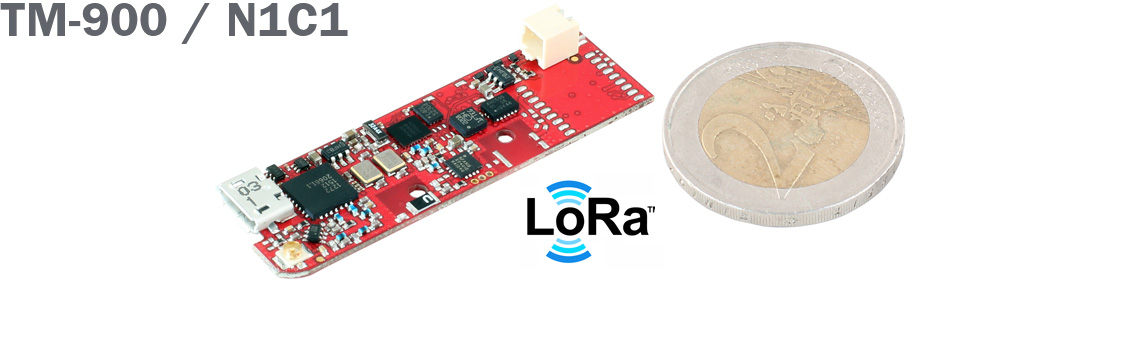
KCS BV has extended its TraceME product line with a low-budget track-and-trace module based on LoRa technology.
The TM-900/N1C1 is a variant of the TraceME GPS track-and-trace product line targeted for tracking and tracing a variety of objects, including livestock, and for personal use.
The full version module is equipped with different technologies for traceability — such as GPS, LoRa, Bluetooth LE, ANT/ANT+ and proprietary RF — which can be combined depending on the application. Traditional national telecom costs are eliminated because of the absence of GPRS/SMS.
Applications include:
Object protection, up to 10 years of standby on a single lithium AAA-battery.
Logistics, M2M.
Animal tracking, asset monitoring.
Security and surveillance.
Remote control and diagnostics.
Anti-theft.
The combined LoRa and 2.4 GHz. RF technologies offer tracing over a wide area up to 10 km. The rough tracing from 10 km down to 300 meters is done by LoRa, while the short-range tracing is done by the proprietary RF-technique, which offers excellent indoor and outdoor tracing with an accuracy up to 1.5 meters.
Unique features include its small size at 49.6 by 15 by 7.5 millimeters, its weight at 3.4 grams and a standby battery lifespan of more than 10 years. Temperature, humidity and acceleration sensors — as well as solar power functionality — enable the integration of TraceME into a variety of custom specific machine-to-machine applications.
Aruba, a Hewlett Packard Enterprise company, has introduced a cloud-based beacon management solution designed for multivendor Wi-Fi networks and beacon analytics. Aruba also expanded its app developer partner program for the Meridian Mobile App Platform to accelerate innovation of location-based mobile apps.
Since its launch in November 2014, Aruba Mobile Engagement, powered by Aruba Beacons and the Meridian Mobile App platform, has improved customer satisfaction in such diverse organizations as Levi’s Stadium and Orlando International Airport, Aruba said in the news release. Aruba Mobile Engagement directly interacts with customers through their mobile devices based on the customers’ in-venue location and personalized preferences.
The new Aruba Sensor is designed to dramatically reduce IT overhead and make it easy to manage all beacons from a single location. Aruba estimates approximately 48 hours of time savings in a 1,000-beacon deployment during a single maintenance window.
The new enterprise-grade Internet of Things Aruba Sensor combines a small, Wi-Fi client and Bluetooth low energy radio to remotely manage beacons across existing multi-vendor Wi-Fi networks from a central location. For IT departments, this means easier and significantly more cost-efficient management and monitoring of beacon data including battery life, power settings and software updates, Aruba said.
Orlando International Airport (MCO), which hosts nearly 38 million travelers annually, implemented Aruba’s Mobile Engagement solution in late 2014 and has since seen more than 26,000 downloads of its MCO mobile app.
“Since so many travelers now rely on mobile apps, the accuracy and reliability of the information we’re delivering is paramount,” said John Newsome, director of information technology for the Greater Orlando Airport Authority. ” Today, to ensure this accuracy, our IT staff must monitor the beacons manually which is burdensome for such an extensive deployment. Using the new Aruba Sensors, however, we’ll be able to manage our beacons remotely, saving valuable time and IT resources.”
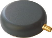
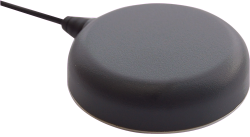
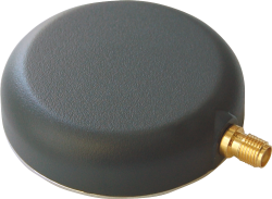
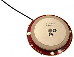
Tallysman has introduced the TW2920 antenna for simultaneous reception of L-band correction signals and all of the upper band GNSS signals, including GPS L1, GLONASS G1, Galileo E1 and BeiDou B1.
The TW2920’s 1-dB bandwidth covers 1525-1559 MHz for the L-band downlink and 1559-1610MHz for the upper-band GNSS.
The LNA of the TW2920 provides 28dB of gain; the TW2940 is a higher gain version with 35-dB LNA gain. The TW2926 antenna is an unhoused OEM version of the TW2920 with 28-dB of gain.
The antennas employ Tallysman’s Accutenna technology, which provides strong cross-polarization rejection for greatly improved multipath rejection, low axial ratio and tight Phase Center Variation (PCV).
All of the antennas include a sharp pre-filter to protect against sub-harmonic signals such 700MHz LTE and strong near frequency signals such as Wi-Fi.
The Tallysman TW2920.
The Tallysman TW2940.
The Tallysman TW2926.
The TW2920 and TW2940 have metal bases with wide temperature range plastic radomes, 57mm in diameter and 15mm in height, with a magnetic mount or adhesive mount along with four tapped screw holes. They are IP67 compliant and available with either a watertight SMA connector on the bulkhead or with a RG174 cable with your choice of connector.
The TW2926 OEM version of the antenna is 56 mm in diameter and has four drilled plated holes for secure mounting within customers’ products. This antenna can be custom tuned to ensure optimal performance within an enclosure.
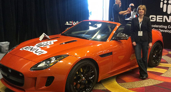
Janice Partyka at the LA Auto Show with a car representing the GENIVI Alliance, a non-profit automotive industry alliance committed to driving the broad adoption of an in-vehicle Infotainment open-source development platform. (Photo: courtesy of Janice Partyka)
LOS ANGELES — The Los Angeles Auto Show’s Connected Car Expo, held Nov. 18-19, puts LA at the intersection of Detroit and Silicon Valley. Cybersecurity garnered attention, as did the impact of the sharing economy on connected features. Caution was urged that these new technologies be carefully vetted for safety and reliability, as failures will impede market acceptance. And research shows safety to be one of consumers’ highest valued attributes that connected vehicles can offer.
Call to action on automotive cybersecurity. Safeguarding the vehicle with its hugely complex supply chain is an enormous challenge. Sensors can be spoofed, wireless sensors and radar can be forged, and cameras can be blocked, warned Andre Wiemerskirch of the University of Michigan Transportation Research Institute. A greater following distance between cars would allow other systems to kick in, should some sensors be hacked. Wiemerskirch appealed for a delay on all connected vehicle features that make a vehicle too vulnerable to hacking until there are better cyber security solutions. He proposed confidence levels for determining the integrity of information coming back from sensors. And he called for a resilient architecture to be created with mature security solutions, such as those used in iPhone security.
A dependable car hacker? Faith in vehicle reliability is one thing; faith that the vehicle won’t be hacked is another. I was looking forward to Chris Valasek’s appearance once again at the Connected Vehicle Show. He is a skilled automotive hacker, who has helped the industry become more secure. You may have read the account by Andy Greenberg in Wired magazine of how Valesek and a cohort hacked Greenberg’s Jeep (with permission) while he was traveling on a freeway. This included disabling its brakes, accelerator and other core functionality. Valasek didn’t show up for his scheduled talk, which, perhaps, can’t be seen as unexpected.
How well do they perform? Connected vehicles struggle with performance in certain environments, warned Thomas Form of Volkswagen. More testing and work are needed for automated cars to handle bad weather, particularly conditions in which visibility is obscured, like fog or sandstorms. Unusual objects, such as tumbleweed skittering across the highway, can cause an automated vehicle to make an emergency stop. What would happen when a traffic light is red, but a police officer points to a driver to go, or indicates she needs to stop at a green light? Form exhorted attendees to test all scenarios, even the unlikely ones.
Will driver skills erode? One attendee asked panelists if with automation, drivers’ skills will become rusty from disuse and be less able to handle manual driving, pointing to the airplane disasters of Asiana in San Francisco and Aeroflot in China. Both flights crashed due to pilots’ confusion with autopilot. The U.S. Federal Aviation Administration (FAA) claims two thirds of pilots make mistakes because of their reliance on technology. A common error is not recognizing that the autopilot has been disconnected. A report from the FAA reads, “pilots sometimes rely too much on automated systems and may be reluctant to intervene.”
Industry worried about sharing. The exponential growth in the sharing economy and declining interest among young people in owning a vehicle was one theme of the conference. If this becomes a massive disruptive trend in mobility, do we know its influence on the uptake of connective technology? The young are most ready to embrace new technology, yet teenage driver license rates peaked in 1982 and have fallen ever since.
New mobility options. Millennials, those born after 1980, are showing less enthusiasm for car ownership and driving than their predecessors. Less than 70 percent of those aged 16-24 have a driver’s license. John Zimmer of Lyft reported that 60 percent of their rides in San Francisco and 50 percent of those in New York City are with Lyft Line, a service in which strangers heading in the same direction share Lyft rides. Not only are riders accepting an unknown person to drive them in a personal car, they don’t mind sitting shoulder-to-shoulder with strangers in the intimate confines of a vehicle. Zimmer reported that Lyft is now looking to offer themed cars, such as those showing sports or other types of entertainment on video screens to create new market “verticals.”
Transforming a personal car into rental vehicle. Cars are vastly under-utilized with the average U.S. household using its cars just four percent of the time with only 1.7 seats occupied on average. This has been duly noted by some car owners, who have created an economy of renting out their vehicles with the help of services like RelayRides. Automakers are taking stock of how Airbnb sliced into the hotel market and are looking at ways to own shared mobility. Ford is one of the OEMs experimenting in the sharing market. Alicia Agius of Ford described Go!Drive, which offers access to a fleet of cars for flexible and affordable one-way journeys throughout London. It also serves to introduce drivers to the Ford brand and build a loyal base among those who become car buyers.
How are we doing? The intersection of tech and automotive is going remarkably well, and the OEMs are proud of how they have cut long development cycles and become more open to new ways of thinking. Tech has prided itself as the innovators, but a speaker from Google humbly remarked, “The automotive industry has been thinking about the future longer than those of us living in Silicon Valley and working at Google.” A nice tip of the hat.
Uber has made big moves implementing location technology by signing a deal with TomTom, buying Microsoft’s mapping technology, and outright purchasing deCarta this year. The company is working with Carnegie Mellon University in Pittsburg to develop autonomous vehicle technology. In other location news, distinct technology is cropping up in the indoor location market to make widespread implementation possible.
Kevin Dennehy
Uber is becoming a big player in the location industry with its announcement this month that it will use TomTom’s maps and traffic data for its ride-hailing service. The deal’s financial terms were not disclosed.
While Uber unsuccessfully made a $3 billion bid for Nokia’s mapping business, it also acquired Microsoft’s mapping technology and the key personnel that came with it. The San Francisco-based company, currently operating in 300 cities worldwide, also acquired veteran location industry deCarta earlier this year.
The mapping data will be key in Uber’s strategy to be a major force in autonomous vehicle development. To research driverless cars, Uber has leased a 53,000-square-foot facility in Pittsburgh.
The question is, what market segment will be first for major autonomous vehicle rollout? At least one executive believes such technology companies as Uber have the advantage. “Because the continued success of [Uber’s] business depends on it, and they have the money to spend on it to gain a competitive advantage,” explained Scott Frank, Airbiquity vice president of marketing. “If ride share companies can reduce the variability and expense of physical drivers, they can reduce the cost of their services — even while improving their margins, and compete more effectively for market share versus private ride services, like taxis/limousines and public transportation, which is more limiting in terms of availability and comfort.”
Frank says his company sees the market differently than others when it comes to autonomous vehicle development and rollout. “Google has been clear since the beginning about their automotive end goal, which takes a very long-range view — produce fully autonomous vehicles connected to public infrastructure with everything connected by Android and enabled by Google computing, data management, service delivery and advertising capability,” he said.
Apple and Tesla’s ambitions are more in close and short-term, in that they want to produce electric vehicles that are better than what the traditional automakers are able to churn out, Frank said.
“Uber is a recent entry into the fray, so it’s a bit premature to put them in the ‘build a vehicle platform’ class, although it’s becoming evident that they are very interested in developing underlying technologies that autonomous cars will certainly rely on,” he said. “In the last couple of months we’ve seen public statements from large traditional automakers referencing their autonomous vehicle ambitions, so they are definitely going to step up and not simply concede the autonomous opportunity to Google — or any another automotive industry newcomers.”
Frank believes there are distinct areas in the United States where autonomous vehicle rollouts make sense. “[Companies are looking at] transportation pain points that autonomous will solve like urban traffic and lack of easy and affordable parking, public transportation infrastructure that can more easily accommodate the necessary changes to integrate and support autonomous, and metro sizes that aren’t so large that it would impossible and/or too costly to get anything done,” he said. “So cities like Portland, Minneapolis, Austin, Raleigh and [such areas as] Silicon Valley come to mind, to name just a few.”
Either way, autonomous vehicles will present huge societal and business changes and such questions as will the public trust the new technology and get them where they need to go, safely and reliably, Frank said. “As with all new technologies there will be an adoption curve at play here with early adaptors taking the lead ahead of the mainstream,” he said. “We saw the same thing with horseless carriages, by the way. People placed more trust in their horses before they began to understand and allow themselves to realize the benefits of motorized transportation.”
In other autonomous vehicle news, Ford said last week it was ramping up its driverless car efforts by being the first automaker to test its self-driving cars at Mcity, a 32-acre prototype town with private roads in Ann Arbor, Mich.
Indoor Location Market Finds Low-Cost Technology
Recent advancements in chip-based indoor location position technology are allowing developers to find a low-cost way to get the capability into multiple devices, said Bruce Krulwich, Grizzly Analytics founder.
“The most exciting aspect of recent advances in chip-based indoor location positioning technologies is that indoor positioning is being added to the next generations of chipsets already being used in today’s smartphones,” said Krulwich, who recently released a new study, Chip-Based Indoor Location Technologies, which profiles GPS, Wi-Fi and sensor processing chips. “This means that the chips that device makers already include in their designs will soon include indoor location capabilities.”
The biggest advantage of chip-based approaches is that they can integrate data from GPS, Wi-Fi and MEMS motion sensors at a very low level, using data direct from the chips, without requiring work by the CPU to enable more efficient and continuous location positioning, Krulwich said.
“While there are many approaches being taken by the chip makers, the one that I’m most excited about is the combination of motion sensing with GPS. In this approach, the same chips that process GPS signals also use data from MEMS sensors, such as accelerometers, gyroscopes and magnetometers, to track locations when GPS signals are unavailable,” he said. “Motion-sensing approaches don’t work forever, since errors in the sensors accumulate over time, but should be able to give reasonable location estimates for 10-15 minutes after a person walks inside. This should be long enough to be a very valuable source of location positioning in between GPS or Wi-Fi signals.
Krulwich said this positioning approach can work anywhere, without Wi-Fi hotspots, BLE beacons or even maps of the site. “This is the closest to ubiquitous location positioning that I’ve seen,” he said.
Krulwich believes the new chip technology will allow the first large-scale incorporation of location technologies into electronic devices, appliances, wearables, Internet of Things (IoT) and others. “A cool example is a camera that tracks an athlete’s location automatically as they run around the basketball court.”
In other location news:
A new agenda is out for Driverless, which will be March 22-23, 2016, at the Crowne Plaza Hotel, San Francisco Airport. The autonomous vehicle conference will feature more than 30 speakers and 15 exhibitors. Go to www.driverlessmarket.com for more information.
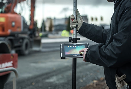
Handheld Group’s new Algiz RT7 tablet is designed for rugged use by mobile workers.
Handheld Group, a manufacturer of rugged mobile computers, today announced the launch of its new Android tablet, the Algiz RT7. The Algiz RT7 is a powerful, lightweight and ergonomic 7-inch tablet designed for reliable performance in demanding environments.
The Algiz RT7, which runs Android 5.1.1 (Lollipop), provides a range of features for mobile workforces, Handheld said. It’s fully rugged, meeting stringent MIL-STD-810G U.S. military standards for protection against drops, vibrations and extreme temperatures, and its IP65 rating means that it’s waterproof as well as fully sealed against sand and dust. Weighing just 650 grams, the Algiz RT7 is designed for mobility.
The Algiz RT7 comes with a built-in accelerometer, gyroscope and e-compass and a stand-alone u-blox EA-7M GPS receiver for navigation, along with built-in Qualcomm IZat location services.
A Qualcomm MSM8916 (Snapdragon) chipset and 1.2 GHz quad-core processor power the tablet, giving it processing speed, ultra-fast connectivity and long battery life. It comes standard with LTE data and voice capabilities as well as 802.11 b/g/n WLAN, BT Class 1 and Class 2, and NFC functionality. It also has dual cameras (8-megapixel rear-facing and 2-megapixel front-facing), as well as dual SIM-card slots.
Designed for the mobile worker, the Algiz RT7 sports a high-brightness 7-inch outdoor-viewable capacitive display that can handle true outdoor challenges. Battery performance is key for any mobile application, and the Algiz RT7 comes with a long-life 3.7V 6000mAh lithium-ion battery. Four programmable buttons allow users to launch and use applications in the field. To enhance data capture, users can choose an optional 2D imager or RFID plus 2D imager.
“Our new Algiz RT7 offers enterprises an exceptional value and is a highly requested product from both our end users and our extensive partner network,” said Jerker Hellström, Handheld Group CEO. “This ultra-rugged tablet delivers best-in-class performance to assist fieldworkers in their daily tasks. The Algiz RT7 is built for tough environments and delivers a streamlined Android experience with power and features appropriate for market demands.”
The Algiz RT7 can be ordered immediately. Shipping will start in December, with volume deliveries starting January 2016.
Project Overlord has launched RimTech in the U.S. Developed by former Nokia, IBM and Motorola executives, RimTech has a built-in GPS, motion sensor and camera, which attach to the tire and act as a security guard for automobile wheels. The vehicle owner controls the device through the accompanying iPhone and Android app, providing total control and surveillance at all times.
Using a two-stage system to eliminate false alarms to police departments, the vehicle owner is immediately alerted of a security compromise. When the car’s tires are approached closer than 3 inches or moved over 3 mm, RimTech will sound a continuous alarm to deter the thief and alert the owner through a push notification on their phone. If the thief proceeds to remove the wheels from the vehicle, a second mobile alert will notify the owner of the movement while police are simultaneously informed of the property’s location and owner’s vehicle information. The owner can use their mobile RimTech app to track the wheel’s real-time location with an accuracy of less than 10 feet.
“The auto industry has yet to introduce a fully comprehensive and effective wheel theft prevention system to the marketplace. Wheel locks are totally ineffective and can be removed in seconds. RimTech is the solution,” said Terrence Gaskin, founder and CEO of Project Overlord. “Project Overlord not only wants to protect your vehicle and its wheels, but also intends to partner with insurance companies to offer discounts for protected drivers.”
According to a recent Yahoo! News article, “Tires and wheels offer a near-perfect combination of attributes to thieves. They’re easy to haul, quick to remove, untraceable on online auction or classified sites, and frequently usable on several different vehicles, with a value that can hit $3,000 and higher per set.”
Product Highlights
App notifies users of tampered or stolen wheels
Alarm sounds if parked wheels are approached or move more than 3mm
App tracks stolen wheels and notifies authorities
Battery lasts a minimum of two days in tracking mode
Device captures at least 25 photos of surroundings and thief