InvenSense Inc. is making available its InvenSense Positioning Library (IPL) software, designed to provide sensor-assisted positioning in places where GNSS alone cannot provide desired accuracy. Invensense is a provider of intelligent sensor system on chip for motion and sound in consumer electronic devices.
InvenSense made the announcement at Mobile World Congress, taking place in Barcelona, Spain March 2-5.
The IPL incorporates advancements in sensor-assisted positioning algorithms that allow use of inertial sensors to improve GNSS positioning in urban areas where satellite signals are either blocked or distorted by multipath, enabling continuous location availability while driving in underground parking lots, tunnels, or walking in urban canyons. The IPL enables continuous and accurate position, velocity and orientation in challenging operating environments.
These sensor-assisted positioning algorithms have been designed to operate under normal pedestrian and driving use without restrictions on the device orientation. Supported pedestrian use includes handheld, hand swinging, in pocket, call mode and belt holster. The algorithms also allow any use within the vehicle, such as in cradle, cup holder or simply left on a seat. The software was designed in a way to maximize accuracy and minimize constraints on the user.
The IPL is designed to operate with an IMU and GNSS receiver as minimum hardware. Integration with a magnetometer, barometer, and vehicle speed sensor is also available, which provides additional heading integrity as well as height and velocity accuracy for sensor-assisted positioning.
IPL is designed for smartphones using Android, iOS, Windows and general Linux operating systems and has already started shipping commercially. The underlying navigation technology comes from years of development at Trusted Positioning Inc., which was acquired by InvenSense this past summer.
“With more consumers using their smartphones for turn-by-turn navigation on foot or in vehicle, one of the most frustrating user experience issues is losing your GPS (GNSS) signal in an unfamiliar location or being re-routed erroneously due to multipath errors,” said Ali Foughi, vice president of Marketing and Business Development at InvenSense. “With IPL technology, high-accuracy location guidance is always available and provides smartphone OEMs with a differentiated user experience and consumers with a more reliable navigation solution.”
The InvenSense Positioning Library is available immediately.
InvenSense is exhibiting in booth #D61 in Hall 7 at Mobile World Congress.
A leap second will be introduced this year at 23:59 on June 30. This phenomenon comes around periodically and is necessary for keeping Coordinated Universal Time (UTC) in line with the small vagaries of the Earth’s slowing rotation. Although it is an event that will pass unnoticed by the majority of people, it has implications for anyone involved in the development of GNSS-enabled devices. For some, it can be the cause of a major headache.
Part of the problem with the leap second is its irregularity. Occurring every two or three years, it means that receiver technology moves on in between — and because the Earth’s slowing rotation is not at a constant rate of change, it cannot be predicted when the next one will be announced. A rapidly developing market of GNSS products having to deal with random alterations to its time framework is not an ideal situation. Suitable preparations, clearly, should be employed.
The behavior of a new receiver when subjected to a leap second may prove critical in certain instances, and without robust characterization it can lead to inconsistent performance. It has already happened this year: on January 21, GPS signals started to include information which effectively announced this year’s leap second event, with the relevant data for future delta time, and week and day numbers. This caused issues with some receivers that weren’t expecting it: some units applied the additional second immediately. It would be interesting to see how these systems might have reacted during an actual leap second transition.
Receiver logic flow requires testing so that any GPS receiver can remain compliant with the IS-GPS-200 standard, and potential problems mustbe mitigated and controlled. The use of a GNSS simulator — which outputs a scenario containing the leap second event — allows for the receiver and any systems around it to be exercised over and over again, ironing out any anomalies, to ensure total reliability.
The recent issues with those non-compliant GPS engines highlights the advantage that simulation provides. The consistency it delivers enables a very thorough testing schedule, which will in turn lead to a straightforward application of the time change.
One school of thought holds that leap seconds should be abandoned, and that we should stick to atomic time from now on. Their removal would mean that by 2100, the Earth’s rotation would be some two to three minutes behind humanity’s precise, atomic-powered, 24-hour clock, and half an hour or so by 2700.
The World Radiocommunication Assembly, which has control over such matters, had been postponing a decision on whether to abolish the leap second for over a decade; another vote is due this year. It wouldn’t be any great wonder if this prevarication continues, so whilst it still exists, it is best to concentrate on what this June’s extra second might have in store for anyone currently developing a GNSS product. Armed with a simulator, the unpredictability of leap second scheduling should no longer be a major concern. Should this year’s vote be again inconclusive, those who have taken the positive step of acquiring a GNSS simulator will be in good shape to deal with the next time the clocks show 23:59:60.
Mark Sampson is LabSat product manager for RaceLogic.
Microsemi Corporation is offering a new Integrated GNSS Master (IGM) solution for small-cell synchronization. The IGM is the company’s first solution that fully integrates a 1588v2 PTP grandmaster with a GNSS receiver and antenna in a small, fully contained package, designed to mount indoors.
The Microsemi IGM solves the challenge of indoor synchronization, which has been a significant hurdle for cost-effective small cell indoor deployments.
According to the Small Cell Forum, 80 percent of small cell needs are for indoor use. Microsemi expects the company’s new IGM to revolutionize indoor small cell deployments by eliminating the need for an antenna on the rooftop along with expensive power, cabling and installation costs associated with connecting the GNSS antenna to the 1588 grandmaster in a typical small-cell deployment.
IGR reports that the cost to deploy a small cell is approximately $31,000 on average and much higher than the cost of the small cell itself. Similarly, the cost of deploying a GPS antenna on a roof is typically $15,000 to $25,000 and can go up to $60,000 in high-rise buildings, in addition to the roof rental expense on a yearly basis.
The Microsemi IGM eliminates the need for an outdoor antenna and therefore significantly reduces the purchase, installation and maintenance deployment costs for typical GNSS antenna systems. The sensitive GNSS receiver and patented Microsemi timing algorithms result in an indoor GNSS timing solution that can be deployed in many different indoor environments.
The IGM uses Power-over-Ethernet (PoE) to simplify installation by utilizing standard Ethernet within a facility and requires no more than 12.95 watts of power directly from the Ethernet cable. The IGM is mounted on the wall or ceiling, connected to the network via PoE, and the unit will automatically self-configure, lock to GNSS signals and provide precise frequency and phase with its 1588v2 PTP grandmaster needed for small cell operation.
“The IGM product introduction is a continued commitment from Microsemi to address market and customer challenges in timing and synchronization,” said Eric Colard, director of marketing and business development for Microsemi’s Frequency & Time Division. “The IGM solution complements our flagship timing products and will work with them in tandem to provide a truly end-to-end timing and synchronization solution.”
“Deploying small cells indoor to provide better coverage and enhance capacity is becoming a priority for operators,” said Richard Webb, Analyst, Mobile Backhaul, at Infonetics, recently acquired by IHS. “The challenge of tight synchronization requirements for LTE has been difficult to solve; Microsemi’s IGM innovative solution enables mobile operators to precisely synchronize small cells indoor and lower deployment costs.”
“The time is right for such an innovative and disruptive solution as IGM from Microsemi,” said Earl Lum, president, EJL Wireless Research. “Since Small Cells for indoor are now being readily deployed, Microsemi solves a critical cost issue and technical challenge operators are facing. The compact form factor, plug and play capability, and scalable client support of the IGM product hits the sweet spot for indoor small cell projects.”
LocationSmart, a provider of cloud-based location and interactivity services, and Locaid, a location-as-a-service platform for enterprise location, have merged to create an enterprise mobility platform for cloud-based location services.
The merger agreement was unanimously approved by the boards of directors of LocationSmart and Locaid, and stockholders of both companies approved the merger on Feb. 19. The combined company will operate under the LocationSmart brand. In conjunction with the merger, LocationSmart secured equity and debt financing led by Intersouth Partners and Hamilton Lane (Florida Growth Fund) to integrate operations and accelerate growth initiatives.
Mario Proietti will continue as CEO of LocationSmart, and Locaid founder and CEO Rip Gerber will serve on the company’s board of directors and as a strategic advisor.
“We are excited that we could join together the two preeminent enterprise location platforms in the industry to better serve our collective customers,” Proietti said. “Working together will enable us to deliver a richer and more robust set of location services that translate into better solutions for our clients. The innovations delivered through our award-winning platforms will continue to lead the market in meeting their needs to locate mobile consumers, workers and assets anywhere, anytime and on any network.”
“This unification of our location platforms is compelling,” Gerber said. “By joining forces, we provide a broader set of location enabling solutions to our enterprise customers, and serve as a more strategic service delivery channel for our wireless carrier partners. This strategic combination makes us very formidable in every part of the mobile location-enabled world. I am delighted that we were able to join the businesses together.”
This combination creates a worldwide cloud-location platform with a customer base of more than 200 brands and companies locating millions of end users to enhance their services and business operations. The merger establishes a stronger platform for future innovation within the mobile location industry, providing significant benefits to all constituencies, including:
Enhanced and trusted, global location awareness of customers, workers and assets
Unified access to a multitude of device location sources with the largest reach in the industry
Reliable and highly scalable enterprise-grade location services available in the cloud
Fully managed and carrier-approved privacy controls compliant with industry best practices
Advancements in international device roaming solutions.
The LocationSmart and Locaid platforms are employed by the Fortune 500 and other leading companies for mission-critical applications in a number of industries including service assistance, proximity marketing, workforce management, emergency alerting, mobile gaming and transaction verification. Through the integration of the two companies and their platforms, customers will be able to access, through a single unified web services interface, the most robust and comprehensive portfolio of cloud-based location services in the world.
Editor’s note: Dennehy is GPS World’s editor for location-based services, writing a monthly column for the LBS Insider newsletter. The views expressed are his own. He will be covering the Mobile World Congress in Barcelona for GPS World. Contact him at [email protected] with your news.
Sen. Ed Markey’s new car technology report, released earlier this month, basically says that connected vehicles can be hacked, causing danger to drivers and presenting major privacy concerns. While some critics believe Markey’s report was meant to drive media hysteria, others say it raises serious issues that the industry needs to address. In other location news, I’ll be covering the Mobile World Congress in Barcelona for GPS World. What will be the showcased location technology? Wearables? Connected vehicles? Or something new?
Kevin Dennehy
By Kevin Dennehy
A report released by Sen. Edward Markey (D-Mass.) earlier this month says that even though drivers have come to rely on new connected technologies, automakers haven’t done their part to protect them from cyber attacks or privacy invasions
First reported by CBS News’ 60 Minutes, Markey’s report, Tracking & Hacking: Security & Privacy Gaps Put American Drivers at Risk, includes information from 16 automobile manufacturers who were given questions about security and privacy. However, few of the carmakers’ answers included how vehicles may be vulnerable to hackers — and what driver information is collected.
Location industry veteran Kim Fennell, deCarta CEO, said the report should be a real concern to the industry. “But it’s more of an issue for autonomous driving and the security of the car’s electronic control system. Even today, the OnStar service, which was a pioneer in the connected car space, can remotely slow your vehicle down in the event of a theft,” he said. “This feature, if hacked, could definitely create massive problems if the proper security technologies are not implemented.”
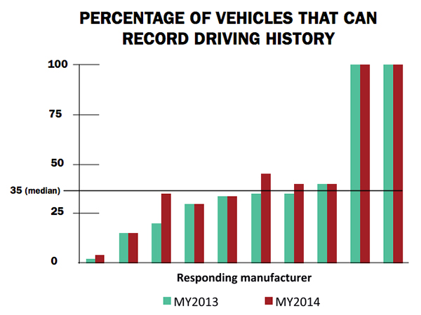
Markey’s report raised additional concerns about the use of navigation and other features that record and send location or driving history information.
Fennell said there should be a distinction between the infotainment systems in the vehicle and the on-board control systems of the car.
“We believe that there should be a strict firewall between these systems so that nothing malicious can happen that is initiated from the connected infotainment system. Any data should flow one way — from the control system of the car to the infotainment system,” he said. “This is not to say that the connected infotainment system shouldn’t be secure, it should be. In working with our OEM and Tier One partners, we have implemented strict security protocols between our servers and their apps.”
Markey’s report found that “[automakers] use personal vehicle data in various ways, often vaguely to ‘improve the customer experience’ and usually involving third parties, and retention policies — how long they store information about drivers — vary considerably among manufacturers.”
In addition, the report found that customers are often not made aware of data collection and, when they are, they often cannot opt out without disabling features, such as navigation.
Percentage of Vehicles that can record driving history
Overall, Fennell hopes that the most malicious thing that could happen in the event of a hack of an infotainment system is that a “Pandora station is changed to play nothing but Justin Bieber songs, the traffic information for your route is projected to be ridiculously long or the Yelp rating of the restaurant that you are going to is lowered down to one star.”
Ultimately though, the driver should be in control of the car and nothing in the infotainment system should affect the behavior of the vehicle, Fennell said.
In terms of driver safety, in a recent survey, deCarta found that more than two-thirds of respondents considered dashboard screens that display videos and other Internet content to be the most dangerous types of onboard information systems. Approximately 79 percent of those polled preferred “voice-activated mapping systems that allow drivers to keep their eyes on the road” as an essential safety-enhancing feature.
“There are two things that infotainment systems could do better to prevent driver distraction. First, instead of replicating the stove-piped app store environment of the smartphone, in-car infotainment services could be better integrated,” Fennell said. “If I find a destination on Yelp, I’d like to send that to my navigation system instead of typing in the address. Second, with today’s better automated speech-recognition technology and text-to-speech engines, it’s now possible to make requests of your infotainment system using natural language commands. Voicebox is doing some great things in this area.”
Fennell said that most existing systems are not connected. “But those that are, aren’t predictive enough. Your navigation/infotainment system should almost work as a concierge,” he said. “It should recognize what time it is and realize you are most likely leaving for work and offer up the best route based on traffic conditions. It should recognize that you are going to a destination in an urban area and offer the most convenient parking to your destination.”
Company Rolls out Indoor Positioning Product that Doesn’t Require Retailer Involvement
After testing and demoing the product in San Francisco last year, IndoorAtlas is rolling out a consumer app called GPSindoor, which uses smartphones to locate shoppers inside a mall. The product features product proximity advertising to allow shoppers to see where they are relative to a product for promotion marketing.
The product includes a crowdsourcing function to allow user-generated data to build indoor maps, wayfinding and other options for shopping promotions, said Wibe Wagemans, IndoorAtlas president.
“We don’t need any retailers per se. We need only the shopper and [their] smartphone,” he said. “There is no brand or retailer involvement if you use our app. Unlike Wi-Fi and Bluetooth beacons, since GPSindoor relies on a community of shoppers, it allows for higher accuracy than static maps. That gives us the confidence to take on the giants like Apple Beacons and Google Indoor Maps head on — we are completely independent of retailers and not dependent on them for our success in becoming the GPS of indoors.”
In other location news:
HERE released a new version of its mapping system for Android, saying it made significant improvements. According to the company’s blog, after more than 3 million downloads, it is shedding the “beta” label with this version. In the beta version, when users asked for a route, the app gave them three car routes. If a user wanted public transit or pedestrian routes, they had to switch to the appropriate tab. This process was slow and inconvenient for people who don’t use a car all the time, HERE said.
In its recent financial statements, Garmin indicated a growing, and profitable, segment is its wearables/fitness band product line. Mio is also expanding its wearable offerings. This should be a big topic at next months’ Mobile World Congress.
I’ll be covering the Mobile World Congress in Barcelona for GPS World. Contact me at [email protected] with your news.
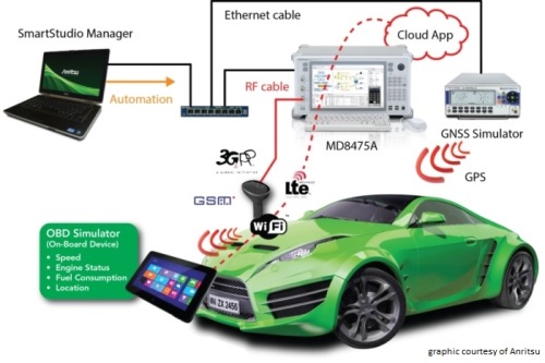
Anritsu plans to showcase a sophisticated, cloud-based connected car system for fleet tracking at Mobile World Congress 2015, which will be held in Barcelona March 2-5. The system was developed by the University of Hertfordshire in the UK with the help of network simulation technology from Anritsu.
The system will be demonstrated using a GNSS simulator from Spectracom to provide location information to the system being tested.
The connected car demonstration will show a car’s diagnostics system connecting to the cloud via a simulated LTE network environment provided by Anritsu’s mobile network simulator, the MD8475A. An application in the cloud enables a fleet manager on any Internet-connected device to view the location and operating parameters of any vehicle in the fleet in real time.
The MD8475A enables the university’s development team to test, from their Hertfordshire laboratory and with a single instrument, how the system’s in-car LTE modem would perform in mobile networks all across the world, and operating according to all major worldwide standards.
The combination of the MD8475A and the Spectracom simulator provides a complete test environment, to simulate any global location, and any type of cellular connectivity, to ensure correct operation of the system. This test bed will showcase the effectiveness of a complete wireless test-bed solution, to enable cost-effective development testing, product validation, and customer experience evaluation within a single system.
Anritsu Corporation has been a communications provider solutions for more than 110 years, with test and measurement solutions including wireless, optical, microwave/RF and digital instruments, operations support systems and solutions that can be used during R&D, manufacturing, installation and maintenance.
Editor’s Note: Janice Partyka is principal of JGP Services, a consulting practice. She is GPS World’s editor for wireless, writing a monthly column for the Wireless LBS Insider newsletter. The views expressed are her own.
Hard to believe, we have only now reached the 10th anniversary of Google Maps. As important as digital maps have become, their purpose is much the same as the printed and drawn maps that preceded them. Digital maps emerged in the 1960s with the Census Bureau’s DIME maps. These first digital maps were used for analysis of place-specific data, such as populations within census tracts or cities. Digital maps in turn led to geographic information systems (GIS) for spatial analysis. Though GIS had uses in fields like city planning, the main stimulus for digital maps came in the 1990s with the convergence of the completion of GPS infrastructure, and affordable and portable computers.
Naturally, just knowing where you are doesn’t have huge value, but if that information can be fused with a digital map, which could generate a route to the destination of your choice, or access information on the places that surround you, then you have something. This is why companies like Etak, Tele Atlas and Navteq began the painstaking process of converting satellite images, printed topographic maps and data that could only be observed with one’s eyes (such as street signs, addresses, speed limits, and turn restrictions) into digital form.
One of my projects during the 1990s was to compare the accuracy of competing digital maps. It was a tedious process, entailing two-person driving crews traveling each street. The passenger recorded all relevant information and made periodic readings with a large, costly GPS receiver. At the time, digital maps could only be accessed by complicated GIS programs which restricted their usefulness.
Since then, digital maps have grown in significance due to the advent of smartphones, a growing suite of digital-map-enabled applications, and of course Google Maps. Google has made maps friendlier to developers through its application program interfaces (APIs), which also improved the user experience for scrolling across locations from a map view.
Google has mastered the process of data capture from roadways. Rather than rely on the eyes of people in the field, sensors and cameras collect mapping data. Image-processing software extracts and geo-codes textual data, automating and enhancing map creation. And Google has incorporated overhead and street-level photographic images into maps, adding substantial value.
We will never arrive at having a perfect digital map. The work to keep mapping accurate and give it more context will be ongoing. The next challenge in digital mapping is making it work offline and creating accurate maps of the indoors. These next innovations will not be led by GPS, but by sensors, including beacons. GPS has already done the heavy lifting.
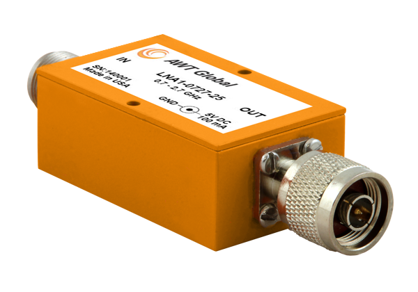
AWT Global has launched a new product line of low noise amplifiers: the LNA1 Series.
The new compact Low Noise Amplifiers (LNAs) are suited as RF measurement amplifiers and for signal boosting applications. LNA1 amplifiers cover telecommunications frequency bands from 700 to 2700 MHz. High gain of 25dB (+/-3) makes them perfect for applications like interference hunting.
“Due to its small form factor, LNA1 is well suited for mobile applications,” said Wolfgang Damm, president of AWT Global. ”LNA1 has been designed with power requirements of 5V/100mA, so it can be supplied by any USB port, standard at most portable instruments like spectrum analyzers.”
LNA1-0727-25 covers a frequency range of 700 to 2700 MHz. Impedance is 50 Ohms and VSWR ratio is 2.2:1. LNA1 features 25 dB (+/-3) of gain and 2.0 dB NF. Size is: 1.5” x 1.0“ x 2.5” ( 38 x 25 x 64 mm). Both, input and output comes standard with N-Type connectors, INP N(f) / OUT N(m). Other connector types are available on request. Power is supplied with a common 5.5 OD, 2.1 ID connector. AWT Global’s LNA1-0727-25 LNAs are available for sales immediately.
Two new apps developed at Texas A&M University-Corpus Christi use social media to help police officers, news stations, and the public navigate the many incidents and minor emergencies that may occur on a daily basis.
Richard Smith, creator of the two emergency response apps, is collaborating with Michelle Maresh-Fuehrer, assistant professor of Communication at A&M-Corpus Christi, to identify how the apps could aid first responders during emergencies.
“With the combination of SituMap and PhotoSorter, the public can be encouraged to submit photos and videos that may be helpful during an investigation,” said Smith, assistant professor of Geographic Information Science and Geospatial Surveying Engineering at the Island University. “For example, during an active shooter event, photos and videos of the suspect or their location can be taken with a cell phone and easily sent to responders. This could drastically improve response time and ultimately save lives.”
Photo credit: Texas A&M
Smith developed the mapping applications to provide a way for first responders to rapidly, and easily, receive and map information so they could have a more comprehensive awareness of emergency situations. Maresh-Fuehrer is working on extending the use of Smith’s social media mapping applications to enhance communication before, during, and after a crisis.
“A crisis event is typically a time of high stress and increased uncertainty for organizations and responders,” said Maresh-Fuehrer, who studies crisis communication strategies. “The applications developed by Dr. Smith have several features that allow for more informed and efficient crisis response.”
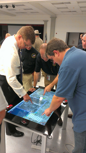
SituMap acts as a tablet-like digital command center that shows officers maps of the crisis area. With the touch of a finger the table-size display can be zoomed, rotated and drawn on. Like a personalized version of Google Maps, officers can search for locations and measure distances. But it goes further than Google Maps. A pin can be created in the application that could represent a person, police car, or groups of people. The pin can be strategically positioned around the area and directions can then be relayed to officers at the emergency location.
“An organization’s crisis team, along with emergency responders, can use SituMap to identify where people should be during a specific crisis,” said Maresh-Fuehrer. “With this application, responders can even view floor plans. This could help to identify safe locations such as fire exits and stairwells.”
PhotoSorter works in tandem with SituMap by allowing emergency responders, crisis planners and community members to share pictures or video of the crisis. Emergency responders can then upload the photos and video into SituMap to help in important decision-making situations.
SituMap and PhotoSorter were designed and developed at the Island University by Smith. The University Police Department is currently using a beta version of SituMap in training sessions.
In today’s digital world, people all over the globe can be connected through social media and, with the touch of a button, information about a major accident can be shared worldwide. With SituMap, important responders, as well as the community, can see real-time information on traffic congestion, roadblocks, and closed roads, which will aid in faster response times. The app also has a weather feature built into it which could be used during severe weather events such as a hurricane.
Three telecommunications companies are joining together to fight patent-infringement claims involving the use of assisted GPS in their mobile networks, reports ZDNET.
Telstra and Optus are Australian telecommunications and media companies, and Vodafone is based in the United Kingdom.
The claim by Australian company Voxson alleges that the mobile network operators are infringing on two patents held by Voxson since the 1990s. One patent, Vox 1, deals with how customers’ mobile phones are tracked on mobile networks, and forms the basis for the assisted GPS used by the networks to deliver location information to their customers. The other patent, Vox 2, deals with video streaming.
The lawsuit was brought against the three companies in 2013, and the allegations cover the 2G, 3G, and 4G networks of all three carriers.
A U.S. judge dismissed the bulk of two lawsuits by LightSquared and equity owner Harbinger Capital Partners, reports Reuters. The suits accused Trimble, Garmin and Deere & Co. of misleading them about interference concerns and hastening the company’s fall into bankruptcy.
In an opinion issued Feb. 5 in Manhattan federal court, Judge Richard Berman threw out Harbinger’s lawsuit, and denied nine of 11 claims by LightSquared.
LightSquared has been in bankruptcy since 2012, when the Federal Communications Commission revoked its license to build a planned wireless network over concerns it could interfere with GPS.
The lawsuits alleged that Deere, Garmin International , Trimble Navigation Ltd, and a GPS industry group led LightSquared to believe the planned network would not pose an interference risk. It wasn’t until LightSquared had pumped $4 billion into the project, the plaintiffs argued, that the GPS industry voiced their concerns.
Judge Berman dismissed many claims from both plaintiffs, including breach of contract and civil conspiracy, leaving alive only LightSquared’s claims for negligent misrepresentation and constructive fraud.
Because the judge did not dismiss all claims, LightSquared could still be able to probe the GPS companies’ books and records during discovery.
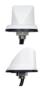
PCTEL has introduced two new fleet-management antennas intended to make high-speed data communications easier. The high-performance antennas include LTE, Wi-Fi, and GPS capabilities in a single low-profile housing.
The first new antenna is a magnetic-mount version of PCTEL’s 5-port multiband fleet management antenna, designed to support temporary installations such as rental vehicle fleets. The 5-port GPS and communications antenna provides outstanding performance for critical fleet management applications, PCTEL said.
LTE MIMO, GPS Multiband Antenna with Magnetic Base
High-performance, low loss cable and high-quality connectors
Rare earth magnets for outstanding pull force resistance
The second new antenna is a sleeker, more aerodynamic fleet-management antenna designed for public safety or other vehicular applications requiring a smaller footprint, making it PCTEL’s most compact multiband GPS and communications option.