Category: Mobile

  • GNSS Frontiers: BeiDou and Ubiquitous Location

    BeiDou Signals, Future Receiver Design Highlighted at Stanford PNT Symposium

    By James D. Litton and Tom Langenstein

    James L. Litton
    James L. Litton

    The Stanford Center for Position, Navigation and Time conducted its eighth symposium on PNT in October 2014. These symposia have always been a superb two (this year three) days of excellent presentations, ranging over the entire domain of PNT, including policy factors as well as technical ones.

    This year the first day featured student speakers, either from Stanford or the students of former Stanford students who are now faculty at other universities. The conference is by invitation only; sponsors include Lockheed Martin, Boeing, and other companies involved with GNSS. This essay highlights two presentations that struck us as harbingers of change in the industry: Greg Turetzky’s paper on ubiquitous location, and Minquan Lu’s and Zheng Yao’s paper on new signal structures for BeiDou.

    Brad Parkinson gave a keynote address mixing challenges and opportunities from the frontiers of policy formation. David Last did not fail to amuse with his lighthearted and satirical commentary on navigation and society at dinner. Many others gave noteworthy presentations, and all of the presentation slides can be found online.

     Tom Langenstein
    Tom Langenstein

    Both papers that we selected for this article have very broad scope with considerable strategic significance in GNSS design and applications. It seems a little impertinent, as well as superficial, to try to convey their essence in fewer than 2,000 words, but the material presented is available elsewhere, too.

    New Signal Structures for BeiDou

    Professors Mingquan Lu and Zheng Yao of Tsinghua University laid out in clear and detailed fashion the motivations for BeiDou’s choosing to introduce new signals for the Phase III global system, analyses of alternative modulations, and the results of bench testing in service to the desired properties (interoperability, acquisition and tracking thresholds, receiver complexity, in-band interference, and so on).

    They emphasized one non-technical or operational motivation: independent proprietary designs for patent protection. No declaration of policy intention was made; however, the direction was clear, even though the authors are university professors and not government officials.

    Some of this work has been published elsewhere in IEEE Transactions by the same authors and has a substantial history, reflecting the lessons learned from the predecessor system designs and very thorough analysis, simulation and bench testing. Space does not allow extensive citation, but the key drivers for the designs and the results are summarized below. The preferred modulations chosen or synthesized are quadrature multiplexed binary offset carrier (QMBOC) for B1C and asymmetric constant envelope-binary offset carrier (ACE-BOC).

    The principal deficiencies cited of the earlier-proposed BeiDou Phase III signals (circa 2010-ICG) were given as:

    • no independent intellectual property rights; thus, a big patent risk 
    • signal performance needs to be improved
    • more flexible receiving modes and more varied application scenarios should be considered.

    The principal requirements for BeiDou Open Service signals were cited as:

    • independent intellectual property rights
    • better compatibility and interoperability with GPS and Galileo
    • smooth transition from Phase II to Phase III
    • improved performance

    Separate requirements were stated for the B1C and B2 signals, as follows:

    B1C: (QMBOC)

    • compatibility with other signals of the same carrier frequency
    • better interoperability with GPS L1 and Galileo E1 signals
    • better ranging accuracy (than GPS C/A and BeiDou Phase II B1(I))
    • receiving mode diversity for different receivers (low-end and high-end)
    • independent Intellectual property rights

    B2C: (ACE-BOC)

    • multiplexed B2a and B2b into a constant envelope signal
    • better interoperability with the GPS L5 and GALILEO E5 signals
    • high ranging accuracy
    • in-band interference-resistant ability (MAI, DME, TACAN, Near-far effect, etc.)
    • joint optimization with B1C
    • independent intellectual property rights

    In the quoted case study tests, simulated ACE-BOC and AltBOC signals were generated at several fixed transmitting power levels and processed using software receivers. For each given transmit power level, the ACE-BOC was allotted three times power for the pilot channel over that of the data channel while the AltBOC allocated equal amount of power for both the pilot and the data channel, that is, 3:1 for ACE-BOC and 1:1 for AltBOC.

    The resulting tracking performance of the ACE-BOC is more robust than that of the AltBOC.

    Table 1, taken from the presentation, provides an overview of the signals.

    Table 1  New signal structures proposed for BeiDou.
    Table 1. New signal structures proposed for BeiDou.

    The compatibility properties of the new signals, if adopted, which seems quite likely, are desirable. The implicit intellectual property aspects of the development, both in motivation and in differential design of a signal structure which seems to be claimed as novel have a defensive basis, apparently, in earlier assertions of proprietary designs. It will be interesting to see whether similar international negotiations follow, or perhaps already have. The paper was well received and stimulated considerable hallway comment.

    Ubiquitous Location

    Turetzky’s paper laid out the phenomenal growth of location-based services and the implications of such growth for design requirements in GNSS-wireless at the user device level and at the silicon level. On growth (from various quoted sources):

    • The compound annual growth rate of GNSS devices will continue, from its current 22 percent level to a robust 9 percent for the years 2016-2022; heading for seven billion installed units by 2022.
    • The cumulative core revenue in the decade 2012-2022 will be 46 percent in LBS portable and wearable devices and 47+ percent in vehicles.
    • There will be many billions of installations of indoor location technologies by 2018, in virtually every venue imaginable.

    Some of the design implications of the requirements driving the growth in indoor location are:

    • Always Located, or continuous location. For this case, the energy dissipated per day (16 hours) and signal availability (100 percent) are the featured specification and the secondary specification, respectively. These specifications, in turn, require hybrid constellations and minimal standby power consumption.
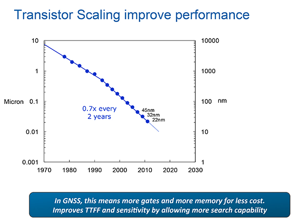
    • The scaling down to very small (14 nanometer) dimensions enables much faster switching speeds, search rates and lower power dissipation in active modes and more complex algorithms, but at the expense of leakage current, which adversely affects standby power, an increasingly important factor.

    Thus, for GNSS design, the challenges are to:

    • Take advantage of benefits of smaller geometries to achieve higher clock speeds, more memory, lower active power and smaller size, while greatly reducing standby power from leakage;
    • Incorporate new methodologies at chip and system design level; Integrate multiple radios on a single die to reduce cost and size without creating interference to a very sensitive GNSS radio;
    • Integrate multiple radio sources into a single location solution;
    • Bring together a disparate value chain;

    Turetzky outlined a vision for his employer, Intel, to be a leader in all aspects of these revolutionary developments. The technology roadmaps embrace most modalities of positioning: GNSS, Bluetooth, WI-Fi, cellular, and SBAS, and cross most platforms, including wearables. We think that another, unemphasized challenge is in the increasing density of these units with the current specifications on out-of-band-emissions and the spectrum sharing and spectrum management factors in the ubiquity of the devices.

    From Greg Turetzky’s Ubiquitous Location paper, presented at Stanford PNT Symposium.
    From Greg Turetzky’s Ubiquitous Location paper, presented at Stanford PNT Symposium.

    Tune in to our free webinar Receiver Design for the Future, with Greg Turetzky of Stanford speaking on Ubiquitous Location, scheduled for Jan. 15 (1 p.m. EST/ 10 a.m. PST/ 6 p.m. GMT). Register today!


    Both papers represented the dynamism of our industry and its diversity of technologies and practitioners and the service to that industry provided by the remarkably consistent excellence of this symposium.


    James D. Litton heads the Litton Consulting Group and previously played key executive roles at NavCom Technology and Magnavox. 

    Tom Langenstein is executive director of the Stanford Center for Position, Navigation, and Time, and deputy program manager of the Gravity Probe-B project.

  • 2014: Big Move to Retail Indoor Location Market

    Macy's plans to add Shopkick indoor location beacons in preparation for holiday shopping. (Photo by Nicholas Eckhart is licensed under CC BY 2.0.)
    Macy’s added Shopkick indoor location beacons in preparation for holiday shopping. (Photo by Nicholas Eckhart is licensed under CC BY 2.0.)

    This year was filled with hope and some success for the location industry. In what was probably the biggest deal, Qualcomm bought United Kingdom-based CSR for $2.5 billion — at the same time, spinning off its own location beacon company, Gimbal. While the connected car continued to get a lot of press at the biggest trade shows, indoor location technology matured to a point that many retailers are believing it’s a way to get consumers back into the stores — and away from their computers.

    As we come to the end of 2014, many industry observers view indoor technology and markets to be like where outdoor location was in the early 1990s: many technologies and providers all pushing different solutions. However, the gap between the beneficiaries of the market, the retailers and brands, and the indoor location technology providers is narrowing as tests become more prevalent.

    Such retailers as Walgreens, Home Depot, Lowe’s, Macy’s and CVS have rolled out, or planning to launch, tests that include indoor mapping and a product locator.

    iBeacons and other beacons proved to be the fastest location-proximity technologies that are being deployed full scale by Macy’s, CVS and other retailers for a first quarter 2015 rollout,” said Kris Kolodziej, an indoor location-based services advisor. “I see more acquisitions like the one of Groupon acquiring Swarm Mobile, a beacon platform for smaller tier-two retailers and businesses. In addition, we will see more partnerships like the one between Gimbal and Urban Airship to provide a holistic outdoor-indoor solution for geofencing and engagement platforms.”

    Location companies paid attention to mobile carriers’ focus on launching and advancing their LTE services in 2014, said Keith Bhatia, TeleCommunication Systems vice president, business development.

    “2014 has been the year of transitioning location-based services from 2G to 3G to complete 2G-3G-4G platforms,” he said. “The other significant location market event for TCS during 2014 has been growth of user plane services by (over-the-top) apps. The operators who have chosen to compete with OTT players have seen location requests exponentially expand.”

    TCS believes that the location market, in the next five years, will evolve to a machine-to-machine and Internet of Things (IoT) concepts that will expand into consumers’ everyday lives, Bhatia said. “From the connected car to telemedicine, health devices, connected home and smart cities, all mobile connected devices will benefit from location-based services,” he said. “We believe that location services will continue its rapid growth for years to come.”

    Selling retails on the promise of indoor positioning and proximity marketing has been tough in the past few years — and some providers have focused on the wrong message, Bhatia said. “As mobile device adoption continues to surge, indoor positioning and proximity marketing will become an important tool for many retailers. A significant barrier so far has been too much focus on coupon delivery,” he said. “We believe the retailers will find real benefits in terms of understanding layout, traffic and congregation of users. Combining this location information with their retail data will provide early insights into trends and early indications of potential challenges.”

    Dave Hutingford, CSR director of product line for location, believes the big selling point for retailers is striking the balance between what benefits they obtain from the app versus what benefits the consumer gets — what he calls the equity balance.

    “Too many irrelevant notifications while walking around the shop will result in people not wanting to run the app, and can potentially harm consumer acceptance of retail applications. The interest is already there from the retailers’ side as the benefits are somewhat obvious, but the question is what do you give back to an increasingly technology-smart consumer?” he said.

    Overall, the indoor location market is attracting major interest from retailers — which is refreshing to many industry observers after seeing online sales cut into brick-and-mortar stores’ profits.

    “Removing the need for dedicated infrastructure to run indoor location was a big hurdle removed from the ecosystem. Certainly we expect to see good pick-up of the solution over the next few months for a wide variety of location services, and being handset-agnostic is a big benefit for any developer,” Hutingford said. “However, if you are looking for accuracy down in the meter range, you will need to add infrastructure to supplement the location calculation, which can come in many forms.”

    Connected-Car Market Made Headlines in 2014

    If an industry executive attended any of the bigger trade shows this year — CES, CTIA in Las Vegas, or the Mobile World Congress in Spain, it was the same thing — connected vehicles are the big story. Adoption by automotive manufacturers, as a number of analysts have pointed out this year, was the most important news story for the connected-car industry in 2014, said John Horn, Kore Telematics executive vice president and chief strategy officer.

    “Essentially every vehicle that rolls off the assembly line in 2015 will have an element of connectivity built into it. To keep up with the level of demand, we are starting to see scale and scope really start to matter to the companies that power this type of connectivity,” he said. “2015 will prove to be another huge year for industry consolidation, which will be necessary to keep up with the global demand for connected-car technologies.”

    The biggest trend in 2014 connected-car technology was the emergence of infotainment content for connected cars, said Scott Frank, Airbiquity vice president, marketing. “Before 2014, the most an average consumer would expect out of a high-end vehicle head unit were features like navigation, basic cell-phone connectivity, and hands-free calling,” he said. “Today, drivers are able to get a wide-variety of apps in their vehicles to do things like stream music and keep up with their social media channels. User experience advancements were also made to provide a seamless transition for digitally oriented drivers as they moved from office, to car, to home, and back again. For example, with the NissanConnect Mobile Apps system, someone listening to a streaming music app like Pandora on their PC in the office can put it on hold, get into their car for the drive home, and pick up the song right where they left off — as well as see their favorite playlists, album selections, and cover art.”

    However, as with any industry that experiences quick growth, there will be growing pains, Horn said. “The automotive world has already started to experience some of those pains as connected technologies continue to advance at a rapid pace. We saw how the analog shutdown left many OnStar customers stranded with obsolete hardware,” he said. “We’ll likely see similarities as 2G, 3G, and 4G networks are eventually turned down in favor of more advanced technologies. I’ve been saying this for years, but now is really the time for the removable module. Connected technologies will turn over much faster than cars, and the only way I can see to future-proof against this is through the removable module.”

    Airbiquity’s Frank said that there are definitely consumer acceptance and technology barriers for the automotive industry going forward related to connected car as we know it today and autonomous car as its being forecast going forward.

    Like waves of technology that have come before, functional consumer awareness and adoption will follow the technology adoption curve, Frank said. “Certain generations and user types will be early adopters and more likely to accept new and evolving connected-car technology and features — and the user experiences and value that come with it — the minute it’s made available,” he said. “While others will be either blissfully unaware of the technology built into their car — and the value it could bring them — or are simply satisfied with traditional technology like basic AM-FM and satellite radio. One thing for sure is there’s a correlation between early adopters of technology like smartphones and early adopters of connected-car technology and related features.”

    Frank quoted a recent Parks Associates study that found 48 percent of vehicle owners that own smartphones are very interested in the ability to view maps — or receive directions in their cars. This compares to 37 percent of vehicle owners that own/don’t own smartphones. “Like flip-phone users that transitioned to smartphones after understanding the end benefits, consumers will increasingly become aware of and use their connected-car systems,” he said. “We’re seeing evidence of the connected-car adoption curve in the increasing activation rates and time of usage for our customer’s connected-car programs.”

    Horn, who headed RacoWireless, which was acquired by Kore for an undisclosed amount this year, said in 2015 industry will start to see the connected car become much more easily monetized. “We’ve seen this first hand, as we have just rolled out some new features with AT&T and Audi. Now, your Audi Connect subscription can be part of your AT&T Mobile Share plan and treated just like another line,” he said. “It is going to be easier than ever to consume in-vehicle connectivity and the business model will advance to the point that makes it appealing for both the consumer and the solution provider.”

    In 2015, driving-centric apps and services will begin to appear and eventually become as important as infotainment content in the consumer purchasing process, Frank said. “The current automotive manufacturers’ focus on providing infotainment delivery reflects their desire to meet the expectations of digital lifestyle consumers who are heavy users of smartphones and want to use their favorite apps and services inside their cars,” he said. “This is a logical first step, but these savvy consumers will increasingly value apps that are truly useful and relative to the driving experience. An example is an app that proactively and dynamically recommends modifications to a driver’s high-frequency routes to help them optimize fuel consumption, lower CO2 emissions, minimize engine wear, and avoid road hazards. As a result, apps that don’t add to the consumer experience relative to driving will eventually die off from lack of use, and automotive manufacturers will replace them with more and more driving-centric apps to satisfy their customers and differentiate themselves from competitors.”

    The rise of autonomous vehicles, a derivative from connected-car technology, will keep automakers, carriers, suppliers and government agencies busy for decades.

    “When it comes to autonomous vehicles, we expect the adoption curve to be more extended than what we’ll see for the connected car, given the increased consumer concerns about safety and adapting to the new fangled idea of riding in a car without a human driver,” Frank said. “Consumers will not only want to know what this fancy new technology is and how it works, they will also need to feel confident that it will run perfectly and not put themselves, their passengers, or other people and property in harm’s way. Consumers will also have concerns about who will be legally and financially liable if an accident occurs.”

    In other location news:

    • Two Trimble companies, PeopleNet and ALK, recently provided real-time tracking of the 2014 Capitol Christmas Tree’s cross-country journey from the Chippewa National Forest in Minnesota to the front lawn of the U.S. Capitol Building in Washington. The companies used enterprise products for routing, mileage, mapping and visualization to track the tree.
    • LBS Insider’s Kevin Dennehy will be attending the 2015 Consumer Electronics Show in Las Vegas next month. Please contact him at [email protected] with your story ideas.
  • Industry Battles Indoor Location Rules

    Janice Partyka
    Janice Partyka

    The FCC will soon make a ruling on indoor location rules for 911 calls. If you worked in the location industry in the late 1990s, you may remember when the FCC ruled that wireless carriers would have to automatically locate a mobile phone that dialed 911 from the outdoors. From a seat on the E9-1-1 Institute’s board, a non-profit organization that supported Congress on 911 public safety issues, I watched the wireless carriers fight meaningful 911 location accuracy standards and monitoring.

    With the large number of calls to 911 from the indoors today, the FCC is about to require carriers to automatically provide emergency dispatchers with indoor location information on calls. In the short term, the FCC is proposing indoor location that would provide sufficient information to identify a building, with more granular accuracy in the long term at the room or office suite level. In addition to horizontal locations, the FCC proposes adding vertical location, a critical metric for multi-storied buildings.

    The comment period for the FCC’s proposal just ended and it is now up to the agency to act. During the comment period, carriers, public safety entities and vendors fought over accuracy rules and monitoring. NENA and APCO, leading public safety organizations, negotiated a consensus agreement on indoor location rules that many other prominent public safety agencies have decried as objectionable. It is surprising that NENA and APCO would sign on to such a watered-down version of the FCC proposal.

    On a better note, indoor location for commercial applications is an industry bright spot. Hyper-location is king and is moving beyond retail to enterprise, personal asset tracking (please find my keys) and the connected home. “Over the past 12 months there has been a considerable change in deployments as companies have moved from a handful of deployments to getting into the hundreds and thousands of stores,” said Patrick Connolly of ABI Research.

    In 2015, Connolly also expects to see camera analytics companies like Shoppertrak, Irisys and Brickstream have an increasing presence as they expand their offerings into BLE, Wi-Fi and in-store analytics. LED lights for location positioning within retail outlets and large public venues are on Connolly’s list for market growth in the coming year. The lights enable communication with the cameras on customers’ smartphones to determine their locations. Retailers can send information, redemptions, maps and services to customers via their mobile device at precise locations within the store.

    I’d like to close the year with a “departure.” In Los Angeles, a proposed cemetery on the tony bluffs of Malibu would forego headstones, raised or flat, and depend on the grieved using GPS to find the burial spots of loved ones. A small disc on the plot would verify the coordinates. GPS as we didn’t imagine it.

  • CSR Preparing for Large Indoor Location Market

    CSR Preparing for Large Indoor Location Market

    SiRFusion SDK brings plug-and-play simplicity to Android app developers.
    SiRFusion SDK brings plug-and-play simplicity to Android app developers.

    With location industry consolidation, several companies are looking at established players to grow niche markets. United Kingdom-based CSR is leveraging several technologies to grow the nascent indoor location market into a powerhouse.

    As GPS World recently reported, Qualcomm agreed to buy CSR, based in the United Kingdom, for $2.5 billion to boost its automotive infotainment and Internet of Things (IoT) offerings.  The deal makes Qualcomm, which spun off its Gimbal location beacon technology into an independent company, a major competitor to chipmaker Broadcom.

    Long term, CSR believes that multiple technologies, ranging from satellite- and cellular-based to local beaconing, will allow consumers to expect higher quality location services, said Dave Huntingford, CSR’s director of the location product line. “As part of improving accuracy, we also expect to see the emergence of dual-frequency operation of GNSS in consumer automotive — and, as part of improving security, better spoofing protection,” he said.

    CSR recently launched its SiRFusion software development kit, SDK, for Android app developers. The company says the software will enable indoor positioning for developers who want to add such new capabilities as indoor location tagging and analytics for social networking.

    “We expect to see good pick-up of the solution over the next few months for a wide variety of location services, and being handset-agnostic is a big benefit for any developer. However, if you are looking for accuracy down in the meter range, you will need to add infrastructure to supplement the location calculation, which can come in many forms,” Huntingford said.

    Hutingford believes the big selling point for retailers is striking the balance between benefits they obtain from the app vs. benefits the consumer gets — what he calls the equity balance.

    “Too many irrelevant notifications while walking around the shop will result in people not wanting to run the app, and can potentially harm consumer acceptance of retail applications. The interest is already there from the retailer side as the benefits are somewhat obvious, but the question is, what do you give back to an increasingly technology-smart consumer?” he said.

    Overall, the indoor location market is attracting major interest in retailers — which is refreshing to many industry observers after seeing online sales cut into brick-and-mortar stores’ profits.

    “iBeacons and other beacons proved to be the fastest location-proximity technologies that are being deployed full scale by Macy’s, CVS, and other retailers for a first quarter 2015 rollout,” said Kris Kolodziej, an indoor location-based services advisor.  “I see more acquisitions like the one of Groupon acquiring Swarm Mobile, a beacon platform for smaller tier-two retailers and businesses. In addition, we will see more partnerships like the one between Gimbal and Urban Airship to provide a holistic outdoor-indoor solution for geofencing and engagement platforms.”

  • Lose Your Wallet? Macy’s Sells One GPS Can Find

    Lose Your Wallet? Macy’s Sells One GPS Can Find

    Royce Leather Freedom Wallet GPS Technology Photo: Royce
    Photo: Royce

    A “GPS wallet” is now being sold at Macy’s department store. Despite its name, the Royce Leather Freedom Wallet uses Bluetooth and a mobile application available on the Apple App Store and Android Market to ensure the safety of your money, according to Andrew Royce Bauer, CEO of Royce Leather.

    Bauer told GPS World that the wallet “utilizes Bluetooth technology through a mobile application within a GPS range of 100 yards in addition to crowd GPS technology, in which every active user can act as a point of location reference.”

    When activated, the “GPS tracker” can pinpoint the location of a lost or stolen wallet. It also has RFID blocking technology to prevent identity theft by blocking waves from scanning devices that can read and store personal information.

    “With the advances in 21st century technology, I was determined to create something better,” Bauer said. “The greatest gift the Royce Leather Freedom Wallet offers is the security of not losing what you already have.”

    The wallet’s mobile technology was designed in California; the leather is Italian Saffiano. According to Royce, the wallet meets the rapidly growing demand for luxury technology. “With this new design, I was determined to elevate the functionality of the traditional wallet,” Bauer said. “You should never lose it.”

    Royce Leather Freedom Wallet Mobile Application Photo: Royce
    Photo: Royce

    The product exclusive to Macy’s is part of a larger fashion accessories collection by Royce Leather. Other styles include the use of DNA-based fingerprint technology and the RFID blocking technology.

    “The Royce Leather Freedom Wallet will financially make a long-term difference in the life of my client,” Bauer said. “Most importantly, the product will reduce the time, stress, and anxiety we have worrying about where our money is. Thankfully, a problem has been solved.”

    Besides the wallet, the designer collection exclusive to Macy’s features the Royce Leather Freedom Briefcase; the world’s first security bag with DNA-based fingerprint technology. The product enables a single user to access the bag, demonstrating the ultimate in personal and travel security.

    The collection by Royce Leather also includes bags, wallets, and handbags for men and women with fingerprint technology, RFID blocking technology, and the Bluetooth “GPS” technology.

  • Aussies Consider GPS for Tracking Footballs — Is NFL Next?

    An Australian company is proposing putting GPS tracking devices in footballs as early as 2015, according to a report by News Corp Australia. Both the National Rugby League (NRL) and the Australian Football League (AFL) are considering using the trackers in footballs as early as next year. The AFL and several National Football League (NFL) teams in the United States already use trackers for player monitoring.

    The battery-operated devices, the size of a 10-cent coin, are made by Melbourne-based company Catapult. The devices have the capacity to influence score decisions and analytics, Catapult said. They can track the ball’s speed and time held in possession by a player, and help provide deeper analysis of the game. Spectators also would get a glimpse, with more details of the game made available to them.

    Catapult already manufactures and sells GPS devices worn by players in various sports including the AFL, and also makes indoor stadium tracking systems for athletes and elite sports teams. The NRL is aware of the technology, but has not yet decided to implement it.

    For the current football season, this year the NFL began using RFID chips for in-game player tracking at 17 stadiums, just over half. The RFID chips, manufactured by MotionWorks, allow the NFL to measure player orientation and capture location information, which is then shared with fans. The data is also used by broadcasters to show plays.

    A quarter of NFL teams and 10 major U.S. college programs are using GPS trackers, mostly for training and injury prevention.

    “The number one goal of this system right now is trying to help prevent injury as well as help us with the rehab process. There are a lot of different things that goes in to it, but the biggest thing is ‘how can we monitor guys on the field to help us get the information’?” said Eric Ciano, strength and conditioning coordinator of the Buffalo Bills.

    “I think us being able to manage practice and how we do it with the GPS system, how we train with that thing year-round, [has] allowed us to take a lot of the guesswork out of how tired your team is, where your pulls, your tears are,” said Jimbo Fisher, head coach of Florida State University football. “Our soft tissue injuries are down 88 percent in the last two years because we’ve been able to apply that. And we use it full-time to gain that information. It’s on my desk, the first thing when we walk in every day.”

  • Cohda Wireless, u-blox Develop System to Warn Drivers of Danger

    u-blox has provided global positioning technology to Cohda Wireless‘ vehicle-to-vehicle (V2V) and vehicle-to-infrastructure (V2I) equipment, collectively called V2X. V2X will be a key technology for the next generation of advanced driver assistance systems (ADAS) as well as autonomous vehicles, the companies said.

    Cohda’s DSRC (dedicated short-range communications) based V2X system uses accurate satellite positioning with embedded dead-reckoning technology provided by u-blox. The system enables early warning of imminent collisions, oncoming traffic, the presence of road workers and unsafe speed based on vehicles in the vicinity.

    “Cohda’s V2X DSRC-based solutions make full use of u-blox’ advanced automotive-grade positioning technology to enhance driver safety through ample warning time and excellent non-line-of-sight performance. Such technology will soon be a standard feature embedded in all vehicles,” said Michael Ammann, VP platform partnerships at u‑blox.

    “Our V2X vehicle warning systems are dependent on highly accurate position and velocity data to deliver the performance that is crucial to meet the safety demands of next generation cars,” said Fabien Cure, Chief Engineer at Cohda Wireless. “u-blox’ satellite positioning solutions, leading automotive dead reckoning technology, module roadmap and clear strategy to deliver lane accurate performance in challenging urban environments was convincing.”

  • From Marriage Proposals to Holiday Messages, GPS Inspires Artists

    From Marriage Proposals to Holiday Messages, GPS Inspires Artists

    Artists are using GPS to create unique messages.

    In October, Jeremy Wood drove all over the United Kingdom to create a Halloween message, reports Metro. Wood drove a 10,000-mile, painstakingly-plotted route through England, Wales and Scotland in a Vauxhall Corsa, plotting a 264,000 positions on the car’s GPS. Wood linked the positions on a virtual drawing to create a picture that shows bats, ghosts, a spider web, and a pumpkin in a witch’s hat, with the word “Halloween” underneath. The result is the image below.

    SWNS_HALLOWEEN_CORSA_04.jpg
    Photo: VB


    Wood isn’t the first GPS-inclined artist. In 2013, a man in San Francisco equipped with an iPhone and tracking app rode his bike 27 miles around the city. Two and a half hours later, Payam Rajabi had etched a heart shape onto a city map.

    heart-W
    Photo: VB

    But the biggest devotee of GPS art could be Japanense artist Yassan, who in 2010 left behind his girlfriend for six months to travel across Japan, reports VB News. Carrying a GPS device, Yassan covered 7,163.7 km mostly by walking, but with some use of a car, ferry, and bicycle. He then used Google Maps to connect the GPS points he visited, resulting in this unique marriage proposal:

    GPS-drawing-Yassan-proposal
    Photo: VB

    Though he made the journey four years ago, his trek is now being featured in a new ad campaign and documentary by Hi-Tec, a company that makes hiking shoes and boots.

    Yassan has been creating large-scale GPS drawings for years. Yassan was so inspired by the possibilities of GPS art that he quit his job in June 2008 to pursue his passion for making GPS drawings. Learn more about Yassan’s GPS Drawing Project on his website.

  • The New Wearable? Clothing with GPS, Wi-Fi Woven In

    The New Wearable? Clothing with GPS, Wi-Fi Woven In

    BB.Suit 2.0
    BB.Suit 2.0 Photo: ByBorre

    Dutch textile company ByBorre and its founder, fashion designer Borre Akkersdijk, have created the BB.suit — a wearable Wi-Fi hotspot with GPS, a music library, and an air purifier.

    Version 1.0 of the suit, which has electrical threads woven into the fabric, was showcased at the SXSW music and film tradeshow in March, where a model’s location was shown on Google Maps, allowing anyone to locate the suit using its GPS data, and then upload songs to a 22Tracks platform.

    Version 2.0 introduces an additional tech — an air purification system. Demonstrated at Beijing Design Week in September, the garment purifies the polluted air surrounding the wearer. According to Dezeen, designers Akkersdijk and Eva de Laat collaborated with Martijn ten Bhomer from the Eindhoven University of Technology, Daan Spangenberg Graphics, and StudioFriso to create the one-piece suit, which looks like an adult onesie.

    “The BB.Suit started because everyone was talking about wearable technology, the bracelets, the glasses,” Akkersdijk told Dezeen. “We thought about how we could really integrate the electrical threads and sensors and not just stick them on.”

    The electrical yarns are woven into the body and legs of the outfit, while the long sleeves and a hood are made from standard textiles. The air-quality sensor at chest level is connected to a hidden platform chip that tracks and transmits data counting the particles of carbon monoxide, methane and dust around the body. The chip is wired to a battery and a cold plasma node on the back of the suit.

    You won’t be able to outfit yourself with the garment yet, as it was created as a step towards a connected wearable platform rather than a product to be marketed.

    GPS World’s December cover story, “The Fashion Demands of Always-On,” discusses the chip architecture requirements of wearables. Read it here.

    byborre-03 Photo: ByBorre
    Photo: ByBorre
  • GPS Tracking, Robots Key in Heavy Retail Shopping Season

    GPS Tracking, Robots Key in Heavy Retail Shopping Season

    An Amazon employee picks items in the company's newest generation fulfillment center. (Photo: Business Wire)
    An Amazon employee picks items in the company’s newest generation fulfillment center. (Photo: Business Wire)

    It used to be when you expected a home delivery, you could specify morning or afternoon, and hope you were there when the truck showed up. In today’s high-tech retail experience, van deliveries can be slotted specifically in two hour, or even one hour, windows. This is just one development in the battle for speed, as major retailers turn to technology to help Santa get presents under the tree on time.

    According to a feature at BBC News, automated route planning and GPS tracking of vans has greatly improved deliveries, along with better warehouse scanning technology, such as the intricate robotic system employed by Amazon in its warehouses.

    Last December, Amazon demonstrated its idea of a drone delivery service, but that technology has yet to launch. For now, the increase in speed it taking place on the warehouse floor, which has turned to robots guided by an intricate barcode system. In 10 of Amazon’s U.S. warehouses, an army of 15,000 robots are helping human employees pick, pack, and ship items.

    A Kiva robot moves product in Amazon's eighth generation fulfillment center. (Photo: Business Wire)
    A Kiva robot moves product in Amazon’s eighth generation fulfillment center. (Photo: Business Wire)

    The system uses robotics, Kiva technology, vision systems and almost 20 years’ worth of software and mechanical innovations to fulfill holiday orders. Amazon purchased the system in 2012 and tested it in 2013, but this is its first year for full deployment. Instead of having employees go to the shelves to find the items for an order, robots automatically deliver the items to them, hauling seven-foot-tall shelving units on their backs.

    The robotic system has made picking products go two to three times faster, employees said.

    The need for speed presents is a huge challenge for retailers trying to offer their customers a seamless shopping experience in-store, online and via mobile, the BBC reports. “Speed is the new battleground,” said Craig Sears-Black, UK managing director of Manhattan Associates, a software company specializing in warehouse management systems. “These days orders have to be processed in two hours, not two days. The physical side of selling needs to be optimized.”

    In the UK, MetaPack handles the delivery of online transactions for 80 of the UK’s top 100 retailers, integrating about 240 delivery companies worldwide into its system. “These days competition amongst carriers is giving consumers a lot more choice over when and where their parcels are delivered,” said Patrick Wall, MetaPack founder and chief executive.

    When a customer selects delivery options, MetaPack works out which are available in which location for which goods. MetaPack then decides which carrier represents best value for the retailer and handles all the tracking data so everyone can know exactly where the parcel is on its journey at any time.

    In the U.S., FedEx is using enhanced visibility technology to help customers plan for package deliveries and pickups. At many FedEx ground facilities, high-speed six-sided camera tunnels with real-time package tracking updates scan every side of a package, enhancing the readability of a shipping label and providing visibility to a package’s location at all times.

    That tracking technology, coupled with network-wide improvements, will offer customers increased visibility this season, including clarification as to exactly when a package is available for pickup at FedEx locations, FedEx said. It also will offer increased visibility into a package’s journey, from the time FedEx takes possession of the package to its estimated delivery date.


  • GTX Corp Partners with Life Button 24 on Emergency Response

    GTX Corp Partners with Life Button 24 on Emergency Response

    GPS-Smartsole
    Photo: GTX

    GTX Corp, a personal location wearables company, has entered a strategic partnership with Life Button 24, a division of World Wide Security Group and provider of life safety, dispatch and monitoring services since 1979.

    Under the strategic partnership, GTX Corp will offer Life Button 24 services to its GPS SmartSole customers, providing 24/7 access to live dispatch operators that can assist caregivers when a loved one goes missing. The premium service will be offered through GTX on a monthly subscription basis as an add-on to existing monthly tracking service plans provided by GTX.

    “Our GPS SmartSoles were specifically designed for caregivers to be able to react in real time to find a loved one who has wandered off,” commented Andrew Duncan, director of GTX Corp. “By partnering with Life Button 24, we will now offer our U.S. customers an enhanced level of service and extra layer of protection. The service will be able to provide a caregiver with the ability to contact a live person, who can assist in coordinating the successful search and rescue of the loved one, or assist in notifying the proper authorities if needed. By offering this service, we enable individual caregivers and assisted living staff, among others, with an additional level of 24/7 human response, when critical support is most needed.”

    “Life Button 24 is thrilled to provide 24-hour emergency response services in partnership with the GTX Corp SmartSole GPS system,” said Jeff Katz, director of project development for Life Button 24. “Addressing wandering issues of individuals afflicted with Alzheimer’s and autism is a growing concern for the millions of families and caregivers. Life Button 24 looks forward to being part of a greater solution that delivers peace-of-mind through advanced tracking technology and customized emergency response services, which were designed specifically to support applications such as the GPS SmartSole.”

    “With initial delivery dates for our GPS SmartSoles to consumers being confirmed next week and several pilot agreements with large organizations kicking off this month, the timing of this partnership with Life Button 24 couldn’t be better. “After several months of integrating and testing our platform and services and having socialized this new offering with some of our larger partners in law enforcement and the assisted living community, we are extremely excited to start offering this service and look forward to a successful partnership with the Life Button 24 team.” Commented Patrick Bertagna CEO of GTX Corp.

  • Broadcom Launches Location Hub with Galileo Support for Smartphones

    Broadcom Corporation has announced a GNSS location hub that supports Galileo. Along with Galileo, the Broadcom BCM4774 simultaneously supports GPS, GLONASS, SBAS, QZSS and the BeiDou satellite systems.

    With a planned deployment of up to 30 additional satellites for Galileo, smartphones with built-in support for this new system will experience an even higher level of accuracy and better positioning with faster times to first fix, Broadcom said. The architecture of the location hub enables the main AP on the smartphone to reduce computation load and stay in sleep mode for extended periods of time by offloading data calculations to the BCM4774. In certain modes, Broadcom’s advanced hardware design and increased memory can reduce power consumption by up to 95 percent over traditional architectures, significantly conserving battery life in mobile devices.

    “Today’s announcement represents yet another navigation benchmark for Broadcom with the industry’s first GNSS location hub for smartphones to support the Galileo satellite system,” said Rahul Patel, senior vice president, wireless connectivity. “We are committed to pushing the limits on location technology by delivering premium performance and enhanced device intelligence while consuming minimal power.”

    Additionally, Broadcom’s new solution recognizes various context states, adding more value to the data that is gathered from mobile devices. For example, a smartphone with the BCM4774 can tell the difference between a user that is walking, running or cycling and provides positioning updates that match the identified state for more precise data results. By processing the data directly on the BCM4774 versus the main AP, Broadcom reduces battery drain and creates opportunities for developers and original equipment manufacturers (OEMs) to determine how this information is analyzed and delivered to consumers, the company said.

    Key Features:

    • Additional on-chip memory delivers complex on-chip positioning and sensor hub capabilities.
    • Easy-to-use API allows OEMs to port their specific sensor fusion code onto BCM4774.
    • Additional hardware optimization further increases AP power savings through offloading of sensor fusion, on-chip positioning, geofencing and location batching.
    • Integration of GNSS receiver and sensor hub reduces board area by 30 percent.
    • Ultra-low power on-chip positioning enables background and foreground location using GNSS.
    • On-chip Wi-Fi positioning using a direct connect communication protocol to Broadcom’s family of connectivity combo chips.
    • Enhanced Batching support with the largest batch space in a sensor hub for all devices connected to the location hub, including Wi-Fi, MEMS and GNSS.