If you’ve been around GPS mapping for any length of time, I’m sure you’ve heard of post-processing, and you may have even experienced it yourself. If you used GPS for mapping in the ’90s, you almost certainly post-processed your data. In fact, sometimes you had to pay for access to GPS base-station data for post-processing. That’s hard to imagine given the widespread, worldwide availability of GPS base-station data on the web today.
SBAS (WAAS/EGNOS/MSAS) didn’t exist, and for real-time corrections and DGPS (beacon) coverage was spotty at best, but real-time commercial DGPS services like OmniSTAR, Landstar, and Satloc were around.
One thing is for sure, no matter what, you have to have some source of corrections to collect GPS data for GIS mapping. It’s commonly referred to as differential GPS correction. Essentially, your GPS receiver needs to reference another GPS receiver (base station) that’s set up on a known position.
Grafnav Post-processing software
There are two primary methods in which to apply a correction to your GPS data: post-processing differential correction and real-time DGPS.
Post-processing
When you’re collecting GPS data that’s going to be post-processed, you need a GPS receiver (and software) that’s going to be able to record satellite observation data. Otherwise, data is collected as one normally would in the field, whether it’s utility poles, manhole covers, road centerlines or polygons of any sort.
The accuracy of the GPS data while you’re in the field is autonomous GPS, so it could be several meters or even ten meters or more. You can’t use this type of method for navigating to a point with any sort of accuracy better than a few meters.
After you’re finished collecting your GPS data for the day, you go back to the office and download your data to your computer. Post-processing requires special software. That software will allow you to search the Internet for the closest GPS base station(s) to use as a source of GPS corrections. In previous years, it was a laborious task to search for GPS base-station data that was recorded the same time as you were in the field (remember UTC vs. local time?). That’s not the case any longer as advanced post-processing software has made this a more automated process. The software will search for the closest base station and automatically select the appropriate files to download.
It takes specialized software and training to utilize post-processing effectively.
Real-time DGPS
This is a method of receiving GPS corrections while you’re in the field. The GPS corrections are applied in real-time so your positioning is accurate. This is useful when you want to navigate to a particular point very accurately. In the 1990s, there were a number of DGPS services, mostly commercial. One would pay a monthly or annual subscription fee to receive the DGPS corrections. During that time, the U.S. Coast Guard started developing a system by which it will install GPS base stations near the major U.S. waterways (coastlines and major rivers). It set up large towers that would broadcast the corrections via 300 kHz radio. Most importantly, it broadcast the corrections free of charge. One only needed a “beacon receiver” to receive the corrections. The system didn’t cover the entire U.S., but it opened the eyes as to what was possible in terms of a regionwide, or nationwide, DGPS network of base stations.
The U.S. Coast Guard concept is still used today in more than 40 countries for DGPS marine navigation. The same GPS correction signal is also used by many people using GPS for mapping.
Around the same time, the Federal Aviation Administration (FAA) began developing a system to improve GPS integrity and accuracy. They called it WAAS (Wide Area Augmentation System). It was the first SBAS in the world and, upon being declared operational in 2003, is in use by thousands of people for GPS mapping. SBAS is a regional system. WAAS only covers North America (U.S., Canada, and Mexico). It has spawned a number of similar and compatible systems such as EGNOS in Western Europe and MSAS in Asia with GAGAN under development in India.
There are several advantages and disadvantages to both post-processing and real-time DGPS for GPS mapping. The primary advantage of post-processing is that you don’t have to worry about a wireless data connection in the field. The primary advantage of real-time DGPS is that you get much better accuracy in the field. There are many other factors you should consider when deciding which method to use.
In fact, I think it’s an interesting enough topic that I’m conducting a webinar later this month that will address both of these methods. I’ve invited Dr. Michael Whitehead to join me. He’s the head technology guy at Hemisphere GPS and has worked extensively developing high performance GPS receivers. He was also the chief architect at Satloc back in the late ’90s.
Eric Gakstatter, Editor, Geospatial Solutions and Survey Scene newsletter &
Dr. Mike Whitehead, VP of Technology at Hemisphere GPS
Event Date: 01/26/2011 10:00 AM Pacific Standard Time, 5 PM GMT
Tens of thousands of users around the world utilize GPS/GNSS receivers for mapping, surveying and navigating. Since autonomous GPS/GNSS typically does not provide the needed accuracy, users must rely on a source of GPS/GNSS corrections. There are three sources of GPS/GNSS corrections available to users who desire reliable GPS/GNSS accuracy in the sub-meter to three meter range: SBAS, DGPS and post-processing. Dr. Michael Whitehead, Chief Scientist at Hemisphere GPS, will join me in presenting a background on the three technologies as well as the strengths and weaknesses of each. I’ve known Mike for a number of years. He was an early innovator in the development of SBAS technology at Satloc as well as SBAS and DGPS receiver technology at Hemisphere GPS. He is one of the leading GNSS engineers in the world. I’m particularly excited about this event and promise a lively discussion that’s full of useful information, data and concepts that anyone using or considering using GPS/GNSS for mapping, surveying or navigating will find useful.
Geodesy is a suite of powerful Earth-observation techniques, associated methodologies, and analysis tools that today are making a vital contribution to science and society. Yet geodesy is not a new, child-of-technology sciaence. It dates back hundreds of years — some would claim thousands of years, and that the ancient Greeks and other pre-Christian cultures shaped its direction. This is illustrated by its classical definition as the science of measuring and mapping the geometry, orientation in space, and gravity field of the Earth; these days we also include their variations over time. At a practical level, geodetic practice forms the foundation for surveying, navigation, and mapping, and the digital datasets underpinning these activities.
What has enabled geodesy to change from an esoteric natural science that underpins the making of maps to today’s cutting-edge geoscience? There are a number of reasons for this transformation. Firstly, modern geodesy relies on space technology, and enormous strides have been made in accuracy, resolution, and coverage due to advances in satellite sensors and an expanding portfolio of satellite missions. Secondly, geodesy can measure Earth parameters that no other remote-sensing technique can, such as the position and velocity of points on the surface of the Earth and the shape and changes of the Earth’s ocean and land surfaces, and it can map the spatial and temporal features of the gravity field.
These geodetic parameters are in effect the “fingerprints” of many dynamic Earth phenomena, including those that we now associate with global change (due to anthropogenic as well as natural causes). The challenge is to invert the outward expressions of these global-change phenomena in order to measure and monitor over time the underlying physical causes.
Finally, what relentlessly drives geodesy into the future is the innovative use of signals transmitted by global satellite navigatiaon systems such as GPS and GLONASS.
Space-geodetic techniques such as GNSS, satellite, and lunar-laser ranging; very-long-baseline interferometry; Doppler orbitography and radiopositioning integrated by satellite (DORIS); satellite sea and ice altimetry; satellite gravity mapping; and satellite interferometric synthetic aperture radar mapping have revolutionized the geosciences. They have significantly improved our understanding of how the solid Earth, atmosphere, and oceans work as a system, giving us new insights into atmospheric and oceanic circulation, the global water cycle, the waxing and waning of ice and glaciers, sea-level rise, global tectonic motion and local earthquake fault mechanisms, to name a few of geodesy’s Earth-observation applications.
Global Geodetic Observing System. GNSS today plays a crucial role in geodesy; however, we will see a massive increase in capability. Geodesy strives to increase the level of accuracy in the determination of these geodetic parameters by a factor of 10 over the next decade.
The Global Geodetic Observing System (GGOS) is an important component of the International Association of Geodesy (IAG). GGOS will integrate all geodetic measurements in order to monitor the phenomena and processes within the Earth system at far higher fidelity than at present. This integration implies the inclusion of all relevant information for parameter estimation, the combination of geometric and gravimetric data, and the common estimation of all the necessary parameters representing the solid Earth, the hydrosphere (including oceans, ice caps, continental water), and the atmosphere. GGOS is geodesy’s contribution to the Global Earth Observing System of Systems (GEOSS) initiative.
Although GPS is popularly associated with the WGS84 datum, an important GNSS contribution to geodesy is its role in the definition of the International Terrestrial Reference Frame (ITRF, itrf.ensg.ign.fr). In addition, high-accuracy differential GNSS techniques — which have been refined over several decades — provide the day-to-day means of determining point coordinates in the ITRF. This reference frame is nowadays the basis for most national and regional datums for mapping and science.
Photo: GNSS
The International GNSS Service (IGS, igs.org) was established in 1994 as an IAG service to the geosciences, providing high-accuracy orbit and clock products as well as open (and free) access to measurements made by a dense ground network of continuously operating GPS/GNSS tracking stations. The IGS therefore supports ITRF maintenance and densification. The IGS nowadays supports many more user communities, such as navigation, surveying, machine guidance, atmospheric remote sensing, and others, both directly and indirectly.
GNSS’s utility includes the role that it plays in precise orbit determination of Earth observation, geodetic, and environmental satellites. GPS receivers onboard almost all such satellites ensure that the data from the satellite sensors can be correctly processed and interpreted. Consider how sea-level rise is measured by satellite-borne radar altimeters. The measurement of the time taken for a radar pulse from satellite to the ocean surface and back is made by the altimeter and converted to distance, but it is knowing where the satellite is in three dimensions to centimeter accuracy that allows the ocean surface to be mapped to extraordinary resolution. Millions of such measurements, over many years, referenced to the ultra-stable ITRF, enable scientists to determine with confidence the 3D position of a grid of points on the ocean surface and its rate of change, not just as a single average rise in sea height, but in its full spatial complexity.
The Challenge. Can GNSS and the IGS rise to the GGOS challenge? Although GPS is currently the only fully operational GNSS, the Russian Federation’s GLONASS is being replenished, and the IGS currently also generates GLONASS products. The European Union’s Galileo is planned to be deployed and operational by 2014 (although that date may slip several years), and China’s Compass is likely to also join the club by 2020, after first deploying a regional navigation satellite system by 2012. Together with dozens more satellites from other countries and agencies, it is likely that the number of GNSS satellites useful for geodesy will increase to almost 150, with perhaps six times the number of broadcast signals on which geodetic measurements can be made.
Simultaneously, the IGS is evolving to a multi-GNSS service, and at the same time improving the quality and timeliness of its products. Real-time IGS products will soon be available to all users.
In summary, geodesy faces an increasing demand from science, engineering applications, the Earth-observation community, and society at large for improved accuracy, reliability and access to geodetic services, measurements, and products. Thus, geodesy must maintain the ITRF at the level that allows, for example, the determination of global sea-level change at the sub-millimeter per year level; determination of the glacio-isostatic adjustments due to deglaciation since the last glacial maximum and to modern mass change of the ice sheets, at millimeter-level accuracy; pre-, co-, and post-seismic displacement fields associated with large earthquakes at the sub-centimeter accuracy level; early warnings for tsunamis, landslides, earthquakes, and volcanic eruptions; millimeter- to centimeter-level deformation and structural monitoring; and more.
In response, the IAG established in 2007 the GGOS, to unify all the geometric
and gravity services of the IAG so as to support the ambitious goals of modern geodesy. Through the IGS, GNSS will play an indispensible role in GGOS. However, the Earth-observing techniques of modern geodesy are but one — albeit under-appreciated — set of applications of GNSS technology. As GNSS performance improves, and as it becomes more and more pervasive, our society’s reliance on this critical utility grows exponentially.
CHRIS RIZOS is professor and head of the School of Surveying & Spatial Information Systems, University of New South Wales, Sydney, Australia. He is vice president of the International Association of Geodesy. He will assume the presidency from mid-2011 for a four-year term.
At the opposite end of this book, my esteemed colleague Eric Gakstatter gives you his Top Five news stories of the recently passed year, from a system point of view. Spend five minutes here in this column, and I’ll toss up the Top Ten for GNSS business, as reported in this magazine.
Not the biggest money deals or revenue generators, at least not in the short term. But the most significant in terms of breaking new ground, pushing out frontiers, integrating with other technologies — the modes through which industry grows and prospers.
I’m leafing through my back copies in reverse order. This listing goes not by prominence, but by reverse chronology.
PNDs Up, Then Down By 2015. When you are doing well, rest assured that someone is gaining on you. Smartphones will gradually take over the personal nav market. Stay flexible, innovate, and be prepared to change horses in midstream.
Rockwell Delivers New MUE. While military user equipment gave this industry its start, the receivers themselves have always lagged behind product available to civil users. Still, security features in the GB-GRAM-M foreshadow what all receivers may eventually require.
Triumph V.S. from JAVAD. Supercharged with capabilities, a veritable surveyor’s arsenal, and probably a gamechanger — whether or not it makes it in the marketplace. A visionary product.
NovAtel OEMV-1DF. Almost every month, another smallest-yet consumer-grade GPS receiver emerges. But when high-precision, dual-frequency receivers grind down their footprint and power requirement, you know this is a future wave that will sweep everything along. Not the only tiny high-performance OEM receiver, mind you, just the latest.
LLC Rusnavgeoset. The joint venture between Trimble and a Russian company will help drive the commercialization of GLONASS, an aspect that system has not yet truly seen. We all talk about the second GNSS of choice, but the second commercialized GNSS is what we really want.
Smartphone Explosion. The flipside to the first story. This year’s models from Apple iPhone, Google Android, Blackberry, Windows Phone 7, and all their kin, if not built around location as Apple claimed, certainly have it as core feature. The flip of the flipside: pricing for the GPS component is cut-throat. Absolutely the worst you’ve ever seen.
GPS-Enabled USB Drive. That’s all it takes — well, download some software and buy a contract — to make a laptop location-aware.
Spirent Assisted-GLONASS Testing. One more sign that the Russian system, against betmakers’ odds, may yet become the trusty sidekick. Soon, if your mobile doesn’t have it, it’s not top-of-class.
One-Chip Receivers-Plus. Hardly breaking news, since it’s been talked about and even done, sort of, for years. TI, Broadcom, Qualcomm, CSR, and silent runners like Sony and Panasonic are all adding some communication transceiver(s) to GPS and squeezing them onto a single piece of silicon.
No News Is Big News. Actually not reported here or anywhere, because neither party wants to reveal anything, but some of the biggest deals are cut by chip manufacturers (such as STMicroelectronics, to name just one), with automobile makers around the world. Like it or not, the car/truck is the dominant mechanical paradigm of our age. And if location is in it . . .
We are indeed fortunate to be part of, and partners in, such a vital scene. Best wishes for this New Year.
With this being my last column in 2010, I’m going to look back at the five significant GPS/GNSS events in 2010 that affected the surveying, mapping, engineering, construction, and natural resource users. Each of these had, or could’ve had, a significant effect on your GPS activities.
These are listed in order of importance with #1 being the most important.
1. GPS 24+3 constellation. The most important GPS/GNSS event in 2010 occurred back in January, when the Air Force announced it was implementing a new GPS 24+3 configuration. You can read about it in in more detail here, but the idea behind it was to eliminate GPS “brownouts.” These are periods in which there are fewer GPS satellites in view, and when combined with obstructions such as rugged terrain or trees or buildings, make GPS difficult to use.
It’s especially an issue with real-time, high precision users (RTK) because RTK technology is satellite-hungry. It needs six or more satellites to provide a robust position solution.
If you recall, in the new 24+3 configuration, there were three satellites moving significantly from their original slots (SVNs 24, 26 and 30). SVN 26 is already at its destination. SVN 26 is scheduled to reach it destination in January 2011. SVN 30 should have arrived at its destination in the past few days.
In addition, three other satellites (SVNs 46, 55, and 56) are being shifted slightly. SVN 55 should arrive at its destination this month. SVNs 46 and 56 are scheduled to begin transitioning in January 2011 and should be complete in May/June 2011.
By now, you should be seeing some improvements in GPS satellite visibility as the 24+3 configuration is almost complete. From the scenarios I plotted in this article, you can see that although you’ll see fewer peaks (high number of GPS satellites in view), you’ll also see fewer valleys (low number of GPS satellites in view). This should increase productivity for RTK users and users in environments where satellites signals are obstructed (such as under tree canopy).
2. Launch of the first GPS Block IIF satellite. Although it doesn’t really help users at this point other than being another satellite to enter service, the Block IIF satellite launched in May is the first to broadcast the third civil signal, L5. The L5 civil signals marks the beginning of a new era in high-precision GPS positioning. The Block IIF launch was the catalyst for the article I wrote I entitled “What’s Going to Happen When High-Accuracy GPS is Cheap?”
It’s just a teaser though, the launch of the next Block IIF isn’t until next summer at the earliest. Then, the next one is ???. They are being launched at a snail’s pace. Remember though, it costs upwards of $200 million to launch a satellite and since there’s already 30+ operational GPS satellites in orbit, it’s hard for the U.S. Congress and the U.S. Air Force to justify speeding up the launch schedule. During the last Air Force briefing I attended, the target was to have 24 satellites broadcasting L5 by 2019.
Block IIF GPS satellite (Courtesy: The Boeing Co.)
3. Continued development of GLONASS. Despite the recent launch failure (three GLONASS satellites crashed into the Pacific Ocean), the Russian Federation was still able to launch six new GLONASS satellites into orbit in 2010, and with another launch scheduled for later this month of the new GLONASS-K1 satellite, that will test the new CDMA capability for better compatibility with GPS.
As it stands, there are 20 operational GLONASS satellites in orbit, with four more offline for maintenance and two reserved as spares. That’s 26 total. Furthermore, after the Dec. 5 launch failure, Russian Federal Space Agency Director Anatoly Perminov vowed to return the GLONASS constellation to 24 operational satellites by March 2011, something that hasn’t been accomplished since the mid-1990s (albeit briefly).
A consistent and healthy number of GLONASS satellites in orbit has given receiver manufacturers more confidence to develop GPS/GLONASS receivers. Just this year, we’ve seen new receivers from several manufacturers that have taken GPS/GLONASS a step further in integrating them into handheld receivers as well as OEM board products.
For users, the benefits are clear, with the new 24+3 GPS configuration and a healthy number of GLONASS satellites in orbit, GPS/GLONASS users are seeing the most satellites in view ever in the history of GPS/GLONASS. Signals from more satellites typically results in more robust positioning and improved productivity due to decreased down-time.
Rocket launch containing three GLONASS satellites
4. Solar activity affect on GPS. Solar activity was eerily quiet in 2010. The big news is that there was no news. There were some minor solar events in 2010, but despite what you may have read, none of them were strong enough or the type that would affect GPS operations.
So, if your GPS receiver didn’t work at times this year, it wasn’t due to solar activity.
With the peak of the current Solar Cycle (SC 24) estimated to occur in May 2013, solar activity should be ramping up in 2011. In August, I conducted a webinar that discussed, among other things, the subject of solar activity on GPS. You can read a summary of it here and even download the webinar presentation.
You can be sure I’m closely monitoring solar activity for any events that look like they will have an effect on your GPS operations. I’m still working on my notification system and will keep you updated on that. Otherwise, the GPS World website is a good source for news in this area.
Finally, I’ll be attending the Space Weather workshop in April 2011. Most, if not all, of the really smart space weather people from around the world gather and confer on space weather. I’ll be writing about what I hear and learn from these folks. But, the sun is a mysterious creature. I like to get definitive answers to my questions, but even some of the brightest scientists I know will answer with “I really don’t know” when I ask them about a certain behavior of the sun. Mother Nature is humbling at times.
Solar Cycle 24 Prediction (Courtesy: NOAA Space Weather Prediction Center)
5. The GEO failures of GAGAN and WAAS. Both the Indian Space Research Organisation (ISRO) and the U.S. Federal Aviation Administration (FAA) were delivered a hard lesson in SBAS GEO satellite management. The SBAS GEO satellites are the ones that broadcast the integrity and correction information to users. They are the critical communications link that connects the SBAS ground infrastructure to the end users. Without them, SBAS doesn’t work.
In April, the ISRO rocket launch of their GAGAN GEO satellite failed, sending the critical GAGAN GEO satellite splashing into the Bay of Bengal. GAGAN is still in testing phase, so no users were affected, but it set back the GAGAN program. However, it didn’t delay GAGAN as much as I thought it might. Another GAGAN GEO is set to launch later this month (as of December 29, the launch date has now been pushed out to Q1 2011) with a second due to launch in the first part of 2012. The ISRO completed its Preliminary System Acceptance of GAGAN just a few days ago. The aviation-certified system is expected to be operational by June 2013. As with other SBAS, test signals usable by non-aviation users will likely be available during the testing phase, as early as 2011.
Also in April 2010, it was reported that the contractor operating one of the FAA WAAS GEO satellites lost communication with the satellite (PRN 135). It was reportedly an unprecedented event. Initially, it was thought that PRN 135 would drift out of usable orbit within a few weeks, leaving North America with only a single WAAS GEO until a new one was brought into service (PRN 133 was already under testing). Things weren’t quite as bad as they seemed as PRN 135 ended up staying in a usable orbit up until PRN 133 testing was concluded.
However, the defunct PRN 135 was at 133° west longitude and PRN 133 is at 98° west longitude. With the remaining GEO (PRN 138) at 107° west longitude, users in northwest Alaska do not have WAAS service. Since none of the GEO satellites are actually owned by the FAA, they have little say in the location of the GEO satellite. The FAA says they are working on putting two more GEOs into service, but that takes time, and it’s not measured in months, but rather years.
I think the hard lesson is not to skimp on SBAS GEO satellites. Perhaps this event will make it easier for the FAA to sell the concept to Congress (for funding).
If you’re an SBAS user, don’t let this bring you down. SBAS is here to stay, and likely you were not affected by any of the above. These past few days, I’ve been looking at SBAS data (and DGPS data) collected over a 24-hour period. The accuracy and stability is pretty impressive.
That leads me into my last subject which is a webinar I’m conducting on January 26, 2011.
If you are using or plan on using GPS for mapping or surveying, you should seriously consider attending this webinar.
Learn the real story behind each of these technologies without a marketing or salesperson’s bias.
Tens of thousands of users around the world utilize GPS/GNSS receivers for mapping, surveying and navigating. Since autonomous GPS/GNSS typically does not provide the needed accuracy, users must rely on a source of GPS/GNSS corrections. There are three sources of GPS/GNSS corrections available to users who desire reliable GPS/GNSS accuracy in the sub-meter to three meter range: SBAS, DGPS and post-processing. Dr. Michael Whitehead, VP of Technology at Hemisphere GPS, will join me in presenting a background on the three technologies as well as the strengths and weaknesses of each.
I’ve known Mike for a number of years. He was an early innovator in the development of SBAS technology at Satloc as well as SBAS and DGPS receiver technology at Hemisphere GPS. He is one of the leading GNSS engineers in the world. I’m particularly excited about this event and promise a lively discussion that’s full of useful information, data, and concepts that anyone using or considering using GPS/GNSS for mapping, surveying, or navigating will find useful.
Have a safe and happy holiday and a Happy New Year. See you next year.
Two Seemingly Unrelated Conferences Linked by GIS and GISP
By Art Kalinski, GISP
In November I attended the Rocket City GIS Conference and the seemingly unrelated Interservice / Industry Training, Simulation, and Education Conference (I/ITSEC).
Rocket City GIS
The Rocket City GIS Conference was organized by Joe Francica of Directions Media. As Conference Chairman, Joe picked an impressive venue, the U.S. Space and Rocket Center, Huntsville, Alabama. The facilities are quite extensive, housing the Saturn and other boosters, the shuttle, and countless historic artifacts including space capsules, space suits, and all manner of test equipment, even a real SR-71. The Rocket Center holds Space Camp for youngsters as well as a team-building program for adults and corporations.
Huntsville is the home of the original rocket scientists led by Werner von Braun, and home to the NASA Marshall Space Center and Redstone Arsenal. The city has become an extensive technology center with the Rocket Center as a focal point. If you visit, plan on a full day to see it all.
Although not a large assembly, the Rocket City GIS Conference was very well organized and the meeting facility at the Rocket Center was superb. The keynote speaker for the conference was David DiBiase, the director of the John A. Dutton E-Education Institute for the online GIS program at Pennsylvania State University. In addition, David is a URISA board member and president of the GIS Certification Institute.
In his opening, David cited two interesting facts. First, according to Forbes magazine, Jack Dangermond, founder of ESRI, is the 164th richest person in the United States. Donald Trump is 153rd. Second, according to the Bureau of Labor there are now 857,000 geo-spatial employees in the United States with expected growth of an additional 350,000 over the next eight years. No one guessed the number was that high.
In 2003 I was in the first group of GIS professionals to receive the GISP certification. Like many other GIS professionals, I participated in the planning and formulation of the GISP program. I felt that it would help hiring managers in the GIS community by identifying GIS professionals who had achieved a certain level of education and experience. I also felt that it would help URISA since the conferences and courses offered by URISA would take on greater importance as candidates looked to build their professional point totals. The program has proven itself over the past seven years, but some believe that it may need to evolve.
David caused a bit of a stir by presenting his desire and others to have an exam for future GISP candidates. He indicated that his opinion was not shared by all board members, but there was a growing interest in the prospect. In 2002 we considered an exam as part of the GISP process, but the general consensus was that it would be impossible to come up with an exam that was comprehensive, fair, and a good indicator of a candidate’s qualifications. I’m not sure that the situation is much different in 2010, but I’d like to hear the pros and cons. Time didn’t permit that, and without further discussion I don’t have an opinion yet.
I/ITSEC 2010
The I/ITSEC conference was held in Orlando and is fairly large. As I reported last year, I/ITSEC continues to evolve from training and gaming technology to much more sophisticated modeling and mission-rehearsal technology. This is a large conference with participation by all the big players such as Lockheed, Boeing, BEA, Raytheon, Northrop Grumman, General Dynamics, and many others.
The Keynote speaker, Air Force General Edward Rice, summed up the prospects for the training and simulation community. Even with feared budget cuts, funding expectations looked good since modeling and simulation are proving to be so cost effective.
Most of us think of flight simulators training pilots, and those are still key systems, but other skills are proving equally cost effective. The general cited fuel-boom operators as one example. There is a real art to operating an in-flight fueling boom, and it takes hours and hours to train operators. The new simulators are so realistic that 95% of training leading to qualification is done on simulators with only 5% actual in-flight time need to qualify operators.
ESRI had a good-size booth demonstrating work of partners such as Precision Light Works 3D models and systems such as Geoweb 3d. The growing evolution from training to actual mission planning and mission rehearsal is driving the need for accurate geospatial data and GIS environments. It’s no longer good enough to just “look good;” the systems also have to reflect reality in a way that wasn’t even attempted a few years ago.
As a retired naval officer and ship handler, I couldn’t resist testing the Navy bridge simulators by CSC. The navigation charts, GPS, radar, out-the-window graphics, physics, and response were dead-on accurate as I piloted a destroyer through Narragansett Bay. Even the small boat simulators by Kongsberg had hydraulic systems that simulated the motion of the small boat through moderate seas. The only thing missing was the salt spray in the face.
Regrettably, realism of medical simulators had also evolved. They want medical personnel to get over the shock factor of real injuries so they can react efficiently during real emergencies. Some were so realistic with spurting blood and missing limbs that the exhibits were not for the faint-hearted. Here is an example of one company that manufactures realistic bodies to train surgeons.
GIS is found in medial simulators as well. The spatial and topological tools of GIS are seeing their way into medical simulators that mimic the circulatory systems and other networks.
At large conferences I always like to visit the small perimeter booths for two reasons. The exhibitors in the outlying sections generally don’t have the budgets that the big companies have, so I try to give them their money’s worth by providing some traffic and visibility. But more importantly, this is where the new technologies are being introduced and some of the booth are quite interesting. One example is this paint booth simulator by VRSim, Inc. The trainee holds a spray gun and wears a helmet with a 3D video display. Using the gun, the trainee sees paint being applied, but even more important, the simulated surface is mapped to later show how heavy the paint was applied. Red = too heavy, Blue = too light, Green = just right.
Paint booth simulator by VRSim. The user holds a spray gun and wears a helmet with a 3D video display.
The simulated surface is mapped to later show how heavy the paint was applied.
Here again spatial data mapping is the basis for the system, and the cost to train an operator is a fraction of the real thing, not to mention wasted paint and fumes.
Orator Plus, Inc. had as robust multimedia data fusion software that permits the simultaneous display of GIS, PowerPoint, video, live web links, imagery, etc. in one elegant environment that also has a common “whiteboard” annotations and sharing capability. The company even developed a portable hardware display to optimize its system. The display is a rear projection multi-touch screen of light-weight Plexiglas. It’s difficult to explain how nice the system works. You need to see it in operation.
Orator Plus’s multimedia data fusion software permits the simultaneous display of GIS, PowerPoint, video, live web links, and imagery.
The second keynote speaker was Dr. R. Bowen Loftin, president of Texas A&M University. His degrees are in physics and he worked extensively for NASA developing virtual environments. His keynote topic was a desire by many to create a certification system / institute for modeling and simulation professionals. This sounded a lot like our GISCI and the GISP program.
I spoke with Dr. Loftin briefly after his session to see if he was familiar with our GISP certification program. He was and had used it as one example for discussions. I later thought to myself that the one advantage we had with the GISP program was our starting point. Although the GISP qualification was not ESRI centric, the common ESRI environments that most of us were operating in created a sense of community and a good foundation for GISP. There is no such common operating environment for the Modeling and Simulation people, not even close. There are many competing companies with no over-arching system, which is a big hurdle. Wait until someone suggests a qualification exam.
The articles in the May and June issues of GPS World on the origins of GPS by Drs. Bradford Parkinson and Stephen Powers presented a detailed view of the people involved in the development of the GPS Program. This view on the origin of GPS essentially begins with the so-called “Lonely Halls” meeting where Dr. Parkinson and a group of Air Force officers invented the GPS concept that was subsequently developed by the teams of people discussed in some detail.
Missing from this view of the origin of the GPS concept are the developments and events leading up to the final decision on what was to have been the Defense Navigation Satellite System. The development, we are now expected to believe, originated from an Aerospace Corporation Study of 1964. The major events in the pre-history of the GPS program are not as well known as the events after the formation of the GPS program since, like the Aerospace study, they were classified and not generally available. Many of the documents of that pre-history have become declassified so that a more historical perspective can be made based on the actual documentation of events rather than subjective recollections of events.
Having worked during that era, I began as a naval officer assigned as the TIMATION project officer, Navigation Satellite Branch, Astronautics Division, Naval Air Systems Command, from 1968 to 1971. After separation from active duty I began working at the Naval Research Laboratory (NRL) in June 1971 in the TIMATION program, through the origination of the GPS Program, the Navigation Technology segment of the GPS program and became the head of the NRL Space Applications Branch in 1984 onwards. I believe I have a unique perspective on the origins of GPS, having participated from the Navy side. In the following I have attempted to describe the evolution of the TIMATION project and events leading up to establishing the GPS Program from the official Navy record.
It should be evident in this discussion that at the formation of the GPS Program, the TIMATION project ended, and the efforts following at NRL on NTS and space clock development were funded by the Navy as part of a Joint Program under the managerial direction of the GPS JPO. This relationship has been considerably de-emphasized and confused over the years, to the point where very few remember it.
The TIMATION project originated in FY 1965 as the Rapid NAVSAT Readout project under tasking by the Bureau of Naval Weapons. This Exploratory Development project was to investigate the feasibility of advanced navigation satellite techniques, among which was the concept of using passive ranging. The project included a number of experimental investigations into the concept of utilizing passive ranging based on precise time synchronization between a satellite and user receiver to produce more accurate and rapid positioning. An experimental satellite was developed and launched into low earth orbit for experiments in determining accurate satellite ephemerides and demonstrating a simplified technique for position fixing based on celestial navigation concepts. These techniques were intended to demonstrate, but were not limited to, two-dimensional positioning. Position fixing utilizing the celestial navigation plotting technique also determined the time offset of the clock in the user receiver so that it could be corrected for positioning or applied to time transfer techniques. An atomic clock was not required. A number of navigation and time transfer experiments were performed with this first satellite and data was collected for analysis of the concept. Another satellite was designed to incorporate the lessons learned from the first satellite and to perform other analytical studies. It was ultimately launched in 1969.
However, in 1968 the Joint Chiefs of Staff (JCS) formed a Navigation Requirements Panel to conduct a study, the results of which were approved on 24 September of that year. The new joint service navigation requirements established by this study included the ability of a user to precisely position themselves in three dimensions and precisely determine their velocity, continuously and worldwide. During the year following establishing of these new JCS requirements, the TIMATION project was expanded to address these new joint service navigation requirements.
Consequently, from 1968 through 1970 the TIMATION concept grew from a category 6.2 exploratory development project into navigation satellite techniques to a 6.3 advanced development system concept employing a constellation of medium altitude satellites containing space qualified atomic clocks to a worldwide distribution of various, surface and airborne, passive ranging user equipment. Technical design studies conducted were designed to analyze or experimentally demonstrate the technical aspects proposed to be selected for the DNSS. The specific technical areas that were investigated were: specific frequencies to be used, single or dual frequencies, and the propagation errors associated with their use; arrangement of the constellation of satellites, total number required for worldwide coverage and quality of coverage; ground stations necessary to operate the satellites and their location (foreign soil or U.S. territory); ranging signals to be used, the accuracy provided, resistance to countermeasures and vulnerability to such things as multipath reflections into a simple user antenna; and capability of being denied to the enemy.
The Navy and the Air Force 621B concepts were the two principal competing DNSS concepts for providing accurate three-dimensional navigational capabilities.
In 1970 the Astronautics Division of NAVAIR, sponsor of the TIMATION project, requested preparation of a system development plan to include a demonstration phase which could directly transition into an operational system. Such a plan was required for the Advanced Development phase (category 6.3 funding) of the project, which began with the establishment of the Advanced Development Objective (ADO) 34-11X, the requirements document for the project. The plan described the project requirements, approach, and objectives in some detail. In their guidance letter to NRL, NAVAIR provided guidance on the content of the development plan. The primary technical requirement for the effort was the “Precision navigation requirements in Phase I of the JCS Navigation Study approved 24 September 1968. — The most stringent requirement (being) user three dimensional position within the stated accuracies continuously on a global basis.”
At NRL a GPS program office (Code 7907) was set up in March 1974 to coordinate GPS activities with the GPS JPO and manage NRL program activities. [ . . . .]
The development of space qualified atomic clocks at NRL, which had recommended and initially focused on cesium standards, began with the experimental rubidium standards on NTS-1. It was originally intended for experimentation with improved quartz crystal standards. The opportunity to include experimental rubidium clocks on NTS-1 presented itself some eight months before the satellite was completed. A new small rubidium frequency standard, model FRK, from Efratom of Munich became available and even though they were not specifically designed for space
their small compact size and design was attractive as a candidate space clock. Several of the FRK models were purchased from Munich, evaluated and modified for a space experiment in NTS-1. Two units were integrated into NTS- 1 and operated alternately with the primary quartz crystal standard. This same Efratom Model FRK was selected and proposed by Rockwell International for use in their Block I satellites. [. . . . ]
The clock development conducted and proposed by NRL was the subject of special program interest during these formative years. In February 1974 DDR&E in a memorandum to ASN (R&D) pointed out that “One of the most vital efforts in the recently approved NAVSTAR Global Positioning System (GPS) is clock development. Funds have been programmed under PE 63401N, NAVSTAR GPS, for programmatic developments defined in the DCP. However, there is a small, but important, effort which should be undertaken … I refer to the development of Space Qualified hydrogen maser clock and its correlative counterpart for the ground control station.” These funds mentioned and subsequent development efforts were Navy funds as part of the GPS joint development effort. The importance and emphasis on space qualified atomic clocks was highlighted in the DDR&E expansion of the GPS Phase I program to support the Submarine Launched Ballistic Missile Improved Accuracy Program. In that memo DDR&E called upon the Navy “to expand their NAVSTAR clock development effort. To reduce risk and provide timely NTS-2 support for the expanded satellite program the Navy should provide a second, parallel, cesium clock development, to be done by an aerospace contractor, for use on NTS-2. If either or both of the cesium clocks perform satisfactorily, cesium clocks should be used in any satellites subsequent to the initial six. The Navy NAVSTAR program should also provide in FY 1976 and beyond for (1) a hydrogen maser development for the NAVSTAR ground stations, and (2) efforts leading to a space qualified maser suitable for NTS-3 and future satellites.”
Considerable documentation and other material describing the extent and contributions to the GPS program resulting from the TIMATION development beginning in early 1974 could be further detailed. But in the interest of keeping this letter relatively brief those aspects will be covered elsewhere.
It should be evident in this discussion that the TIMATION project ended at the formation of the GPS Program. The subsequent NRL efforts on NTS and space clock development were funded by the Navy as part of a Joint Program under the managerial direction of the GPS JPO, however, many of the fundamental concepts and approaches began during the TIMATION program.
It is worthy to note as well, that over the years in addition to the recognition afforded Dr. Parkinson as the first program director of the GPS program, the contributions by Roger Easton and NRL have also been recognized. This recognition includes NRL being included as a major contributor to GPS in the Collier Award of 1992.
— Ronald L. Beard
Head, Space Applications Branch,
Space Systems Development Department,
U.S. Naval Research Laboratory,
Washington, D.C
Brad Parkinson replies:
I have great respect for Ron Beard and the many other fine engineers and spacecraft developers at NRL.
That said, I respectfully submit that the letter completely misses the point. There was a substantial amount of Pentagon infighting up to the time I took over the Program in late 1972. Ron has done a great job in documenting this cumbersome history. It accurately shows the paper trail from the NRL point of view. Dr. Currie reset the direction when he designated me to lead the Joint Program in 1973. The past assignments were essentially overtaken by that decision. There is another set of paper, that could be dredged out of the USAF files, but to little point.
The central issue is not paperwork. It is who conceived the concept, demonstrated the technique on the ground, and built the prototype system.
With a wave of the hands, NRL declares their system was also three-dimensional, yet the Easton patent clearly was not and the patent was clearly burdened with a militarily- vulnerable signal structure. Apparently they disown their own preferred design. Yet, the patent is the clearest public record of NRL thinking.
The letter ignores:
The first clear explanation of the tradeoffs between the various space navigation alternatives was the 621B “Woodford and Nakamura” study of 1964/66. It included the three-dimensional technique we selected in the final GPS design.
The essential keys were: A. Single frequency transmission (CDMA) and B. Simultaneous ranging to four satellites. Both keys were conceived by 621B and demonstrated by the White Sands testing of real hardware (1970/1973). This became the basis for the GPS design in 1973. It is also the basis selected for all of the “copycat” systems by other countries (Russia has now announced a CDMA signal). NRL cannot point to any advocacy of such a system.
NRL was indeed (as Ron points out) charged with clock development (but their spacecraft CDMA transmitter was provided by the JPO, not by NRL). Note that the early 621B study advocated atomic clocks in space for the system. NRL was not able to provide a useful space-borne clock until the fifth GPS prototype satellite. This was after the Rockwell/Efratom clock had become the only operational satellite clock used in the first four prototype satellites and after the GPS system testing had gained approval to proceed to full-scale development in 1980. Problems with the NRL test satellite precluded its inclusion in the test constellation.
It is correct that NRL advocated a MEO system, similar to the one we adopted for GPS. The Air Force’s 621B had wanted to demonstrate the four-dimensional technique using spacecraft, and launching the system a world-sector at a time. There are pros and cons both ways, but the controversy was both political and technical. The key to our selecting the GPS MEO constellation design was that it enabled the 4-6 satellite sub-constellation that was star (not solar) synchronized and that technique can be attributed to Major Gaylord Green of the Air Force. This allowed the extended testing on our well-instrumented range at Yuma Proving Ground.
In 1973/74, my problem was to find a way to advocate the right system without re-igniting the NRL/621B warfare. At that time, I chose to ignore most of the true 621B heritage of the JPO proposal and, in public, talk up the NRL contribution. A number of my colleagues in Aerospace and the old 621B were very perplexed with my behavior. I felt it was the right path to allow us to proceed with actually building the system.
I genuinely supported the NRL clock technology efforts, and was very disappointed when they were not able to meet our schedule. The space-qualified cesium clock, developed under NRL/Bob Kern, was a phenomenal accomplishment in spite of being late.
— Bradford W. Parkinson,
Edward C. Wells Professor of Aeronautics and Astronautics (Emeritus)
and Hansen Experimental Physics Laboratory
Stanford University, Stanford, California
From a distance, the Garmin-Asus partnership to produce GPS-enabled smartphones looked pretty good — particularly during the market erosion for portable navigation devices. However, published reports indicate that the companies will not renew their partnership in January 2011.
Switzerland-based Garmin and its Dutch competitor TomTom have seen steeply declining sales for personal navigation devices (PNDs) since the high point of the market two years ago, industry observers say.
“[The Garmin-Asus divorce] was predictable. The product didn’t sell very well and no partnership can survive forever if there’s no revenue coming,” said Marc Prioleau, Technology Growth Advisors principal. “The smartphone market is incredibly competitive and navigation is a pretty standard feature. So you’ve got small revenues, limited differentiation…not much to build a long-term partnership around.”
Since the Garmin-Asus strategic alliance in February 2009, the companies said they have developed and marketed six devices. These products are available through carrier and retail channels in several countries. One of the phones, the Garmin-Asus A10, a touchscreen smartphone running on the Android platform, is optimized for pedestrian navigation.
Location-Based Advertising. TeleNav, which now has 17 million subscribers, recently launched a navigation-based mobile advertising platform that allows businesses to place a sponsored listing at the top of the search results located in its mobile navigation applications. The company says users can click on a sponsored listing to receive additional information such as coupons or menu information.
The user can call, map, or receive turn-by-turn directions to the business — all of which are actions TeleNav measures and reports as metrics to advertisers. Sounds like an interesting concept — but are carriers committing to it?
“We see location-based advertising (LBA) as a natural and important extension of our business. As an industry, I feel that we are only at the tip of the iceberg on advertising within the intersection of location and mobile,” said Ky Tang, TeleNav director of marketing. “This is new for us and for the industry as a whole. While it’s difficult to speak on behalf of a carrier, in general, I’d say that they too see a significant opportunity here.”
TeleNav released data saying which brands are winning the battle for the attention of the mobile consumer. Through analyzing keyword searches of millions of its mobile users, the company is able to identify where consumers are looking to go while on the road.
“We do not in any way, shape, or form provide user-specific information to our advertisers,” Tang said. “We only provide aggregate information of how our users are engaging with their ads within our application. So in addition to the traditional impressions and clicks, we let advertisers know how many people conducted a ‘drive to’ to a specific business.”
Tang said that, in regard to the company’s data analysis, it does provide aggregate data on what users are searching for when using the application. “We believe that this type of information is insightful for brands to really understand how users who are on the go remember and prefer certain brands over others,” he said. “For those whose brand equity isn’t as strong — as measured by how often our users search for their specific name — we give them the ability to promote their brand to the top of the list. One of the implications behind this is that in the mobile, location-based arena, perhaps there’s an opportunity for more brand equality.”
While it remains to be seen whether the LBA space is close to seeing rapid growth, some advertising agencies are taking notice. “Some leading, innovative ad agencies see it and get it right away. But by and large, there’s still a lot of education that is required in this space,” Tang said. “Location-based advertising is very powerful and we see it to represent the next major wave of digital advertising. But in the same way that it took online advertising some time to blossom and become more mainstream, we see the same thing here for location-based advertising.”
On November 1, 2010, China’s state news agency reported that the sixth Compass satellite was launched from the Xichang Satellite Launch Center. This was the fourth Compass satellite put into orbit this year, following launches in January, June, and August. Joining the United States, Russia, and the European Union, China is deploying is own global navigation satellite system of five geosynchronous satellites, 27 in medium Earth orbit (MEO) and three in highly inclined geosynchronous orbits (IGSO).
Sometimes referred to as Beidou-2, Compass is a global RNSS (radio-navigation satellite system) that broadcasts one-way precision time signals to enable receivers to calculate their position. An earlier Chinese satellite navigation system, Beidou-1, was an RDSS (radio-determination satellite system) that provided regional coverage and required two satellites to get a position fix using two-way communications with a centralized ground station.
Like the U.S. GPS and the European Galileo system, signals from Compass use the CDMA (code-division multiple access) channel access method as distinct from the FDMA (frequency-division multiple access) method used by GLONASS. CDMA enables more precise positioning as compared to FDMA, and GLONASS is planning to shift to CDMA for its future satellites.
Compass is designed to operate on three primary L-band frequencies:
1559.052–1591.788 MHz,
1166.22–1217.37 MHz,
1250.618-1286.423 MHz
while offering both an open service and an authorized service. The latter is expected to require cryptographic keys for access and will be reserved for military and public safety-related uses. Compass is intended to provide service to the Asia-Pacific region sometime in 2012 and to attain global-service levels around 2020.
Reasons for Compass
The Russian GLONASS was developed to support the Soviet Navy, and the U.S. GPS arose from the merger of previously separate Air Force and Navy satellite navigation efforts. China began researching satellite navigation and positioning technologies in the 1960s, but it was not until 1983 that a plan for satellite navigation and positioning system was developed. The “Double Star Rapid Positioning System” was the basis for the Beidou-1 two-satellite RDSS system that was formally approved for development in 1994. The impetus for the Compass systems is not fully known, but press reports attribute it to military requirements for more accurate missile targeting.
The Chinese were close observers of the role of GPS in the first Gulf War. Chinese writings on military doctrine began to talk of “war under informationalized conditions” and how information from space-based systems such as GPS was changing the nature of modern warfare. Exploiting these new information sources required not just space capabilities but changes in how military forces were organized, trained, and equipped.
Chinese security interests encompass not only China itself and nearby areas, but also the sea lanes that enable the import of raw materials and export of finished goods. In recent years, China has shown an increasing interest in “maritime domain awareness,” in which satellite navigation is used for monitoring the transit of ships in the Indian Ocean (for example, oil from the Middle East) and the South China Sea (minerals from Australia, fishing zones). Satellite navigation is a dual-use, commercial and military, interest for China, and this may have prompted support for the more advanced, independent GNSS that would become Beidou-2 or Compass.
Regardless of the cause, People’s Liberation Army officials have said that China needs it own satellite positioning system to ensure its ability to conduct independent military actions. The later 1990s saw continued Beidou-1 satellite deployments while design of the newer Beidou-2/Compass satellites began. China joined the Galileo consortium in 2003 but abandoned it in 2006 in dissatisfaction over access to technology and work share arrangements. Efforts on Compass accelerated, and the first experimental satellite of the new system was launched in 2007.
In a September 2010 interview with Chinese press, Duan Zhaoyu, vice president of BDStar Navigation, said that there are currently more than 20,000 civilian users of the Beidou-1 navigation system, 60 percent of whom use products from his company. More than 10,000 of these users are fishermen in the South China Sea. Not surprisingly, the Chinese government and military constituted the majority of users as it was also reported that as of August 2009, there were only 60,000 Beidou users in total. The number of registered terminal users amounted to only 1 percent of the system’s capacity, leaving the satellite resource seriously under-used.
The underutilization of Beidou-1 is both a challenge and an opportunity for the Compass system in both domestic and international applications. The designer of the first Chinese satellites and current Beidou chief designer, Sun Jiadong has stressed the importance of actual utilization in arguing that “satellites in the sky should be coordinated with ground applications” and “pushing China’s Beidou satellite navigation system to bring as much economic and social benefit as early and as quickly as possible.” In order to do this, “…the state should promulgate corresponding policies, regulations, and systems as soon as possible to support development of the new satellite navigation application industry. It should guide, encourage, and attract even more Chinese enterprises and public institutions to actively participate in the construction of an industrial chain for ground applications.”
Internationally, China has stressed cooperation with other GNSS systems. At the June 2010 meeting of the Asia-Pacific Economic Cooperation (APEC) organization, the Chinese presentation said that Beidou-2 (Compass) would “provide high-quality open services free of charge from direct users, and worldwide use of Beidou is encouraged,” and that Beidou-2 will “pursue solutions to realize compatibility and interoperability with other satellite navigation systems.”
While satellite deployments have been accelerating, there continue to be delays in the public release of interface control documents (ICD) for incorporating Compass signals into GNSS receivers. The technical preparation of Beidou-2 Signal-in-Space ICD (version 1.0) has reportedly been finished but has not yet been posted on the Chinese government website for the program at www.beidou.gov.cn. In October 2009, Cao Chong, the director of the consulting center at the China Technical Application Association for Global Positioning System, gave a speech at Stanford University where he said that English and Chinese versions of the ICD have already been completed. But their release had been postponed due to pressure from domestic companies in China.
The point of an open ICD, as done with GPS, is that as soon as it is released, anyone can use it on an equal basis. Reported opposition from Chinese companies seeking to gain a head start on foreign competitors would seem to indicate a domestic misperception of RNSS systems and an internal contradiction in Chinese policy toward Compass. Like other RNSS systems, Compass does not use a two-way signal for which direct users fees can be easily assessed; thus the idea of “head start” is illusionary. The necessary technologies for RNSS receivers are all found in consumer electronics and software — areas in which C
hina is already capable.
In addition, efforts to discourage or delay foreign adoption of Compass signals poses the risk of the system being of limited relevance to global markets, as is the situation of Beidou-1 today. This is contrary to the stated intent of the Chinese government that Compass be a world-class GNSS system.
ITU System Coordination
A primary concern of all GNSS users and operators is compatibility, that is, the ability of multiple satellite navigation systems to co-exist in the same international spectrum allocations without causing harmful interference to any individual service or signal. The signals may or may not be interoperable but they should not harm each other. In the case of Compass, its signals do overlap some Galileo frequencies, particularly with respect to the Galileo Publicly Regulated Service (PRS) and to a lesser extent the edges of the GPS M-Code that is used exclusively for defense purposes. In general, however, Compass signals do not overlap the GPS or GLONASS frequencies. Informal Chinese comments suggest that they consider GPS and GLONASS to be well-established “legacy” systems that new arrivals should seek to avoid overlapping. On the other hand, Galileo and Compass are seen as having equal standing as new RNSS systems within the terms of the International Telecommunications Union (ITU).
Chinese presentations have identified several Compass signals that would overlap those of other GNSS providers. These include the Compass B1 at 1575.42 MHz with the GPS L1 signal, B2a at 1176.45 MHz with the GPS L5 signal, and B2b at 1207.14 MHz with the Galileo E5b signal. The Chinese believe that “the frequency spectrum overlap of open signals is beneficial for the realization of interoperability for many applications” and makes it easier to develop and manufacture interoperable receivers. While these claims are true to a point, GNSS providers experiencing the overlap may not agree.
Even if signals do not experience harmful interference from an overlap, the signal provider may suffer constraints on its ability to control the service it provides to specific users, as in public safety or military applications. The long negotiations between the United States and the European Union over Galileo proposals to overlay major portions of the GPS M-Code eventually resulted in the 2004 US-EU Agreement on GPS-Galileo Cooperation. More recently, the European Union has raised its concerns with China’s plans to overlay Compass signals on the Galileo signals used for the PRS service.
Within the ITU, RNSS operators (which includes the GNSS system providers) engage in direct coordination under what is known as a Resolution 609 process. This process was adopted at the 2003 World Radiocommunication Conference in Geneva, Switzerland and calls for “Consultation Meetings between administrations operating or planning to operate systems in the aeronautical radionavigation service (ARNS) and systems in the radionavigation satellite service (RNSS) in the 1164–1215 MHz frequency band.” It should be noted that the resolution does not encompass all GNSS signals, but does focuses on those at the GPS L5, Galileo E5, and Compass B2. The most recent meeting was the 7th Consultation Meeting of Resolution 609, June 23–25, 2010 in Toulouse, France.
EPFD Levels. As the Resolution 609 process has continued, calculations of aggregate, equivalent power flux density levels (epfd) show that levels from filed RNSS systems (some operational, some planned) are nearing the allowable maximum aggregate epfd level. This level is specified in Resolution 609 itself, as revised at the last World Radiocommunications Conference (WRC-07). The United States position is that it is important to discuss methods to ensure that this limit is not in fact exceeded.
The Toulouse Consultation Meeting discussed three potential methods to achieve this important objective:
use of actual operational characteristics (for example, maximum operational power levels, instead of filed parameters);
use of the actual number of satellites in orbit, instead of the filed number; and
technical revisions to the epfd calculation methodology (per ITU-R Recommendation M.1642-2).
The meeting also considered proposals in the case where calculations show the aggregate epfd level would be exceeded, to perform a second aggregate epfd calculation including only satellites that are in actual operation, or are planned to be in operation before the next Resolution 609 Consultation Meeting is scheduled to occur (that is, within the next 12 to 16 months). The point of the second calculation would determine that epfd actually being produced from RNSS satellites in the 1164–1215 MHz band will not in fact exceed the allowable epfd limit.
In addition to the Resolution 609 multilateral meetings, the United States and China have also engaged in five operator-to-operator coordination meetings under ITU auspices from 2007–2010. The United States has also offered the possibility of direct bilateral talks with China on GNSS services and applications — as was done with Japan, Russia, and the European Union.
Europe similarly has sought to have direct talks with China to coordinate their concerns over Compass-Galileo. There have been at least six meetings on frequency compatibility and interoperability during 2007–2010, alternating between Beijing and Brussels. While both sides continue to express support for compatibility and even interoperability, the European side continues to oppose Compass overlays of the Galileo PRS while China shows no indication of being willing to change its frequency plans.
Finally, with respect to Russia, a Beidou-GLONASS frequency compatibility meeting was held in Moscow in January 2007, but there seems to have been little follow-up. Given the lack of overlap between the frequencies used by the two systems, this is not surprising.
International GNSS Coordination
Compass is represented in broader GNSS coordination activities, not just those involving the ITU. The most important of these is the International Committee on GNSS (ICG) that was established in 2005 as an outgrowth of the United Nations Committee on the Peaceful Uses of Outer Space (COPUOS). The most recent, and fifth, meeting of the ICG was held in October 2010 in Turin, Italy.
The purpose of the ICG is to “promote the use of GNSS infrastructure on a global basis and to facilitate exchange of information.” Through meetings of the ICG, GNSS providers have adopted various principles such as transparency for open services, that is, every provider should publish documentation that describes signal and system information, policies of provision, and minimum levels of performance for its open services.
On a regional basis, China participates in the APEC GNSS Implementation Team. This team was established by the APEC Transportation Working Group in 2000 with a mission of promoting regional GNSS augmentation systems to enhance inter-modal transportation. The United States hosted the 14th APEC GIT meeting this past June in Seattle, Washinmgton; the next meeting is tentatively scheduled for Brisbane, Australia, in May 2011. The significance of the APEC meetings on GNSS is their recognition of the value of such systems to states at greatly varying levels of development, not just the providers of GNSS or major GNSS augmentations. Although the group has a transportation focus, the productivity, safety, and environmental benefits of GNSS uses provide an incentive for common efforts across the Asia-Pacific region.
In addition, the group calls for cooperating with non-APEC organizations (such as the ITU) as necessary to provide for seamless implementation.
Strategic Significance of Compass
Unlike Galileo, Compass is not a multinational cooperative program nor did it ever consider being a public-private partnership. Like GPS and GLONASS, Compass was created as an independent strategic effort by
a national government for military and economic benefits.
Unlike the history of GPS and GLONASS, however, the Chinese government from the beginning recognized the dual-use nature of Compass signals. Like GPS today, Compass plans to deploy CDMA signals at multiple frequencies to support a full range of application, from transportation to precision positioning and timing.
Like Galileo, Compass still has to demonstrate that its signals are stable, operationally reliable, and accurately represented by published interface control documents to attract manufacturers to build the capability into their products. Galileo, Compass, and GLONASS all have the challenge of meeting the expectation of the existing installed base of billions of GPS users — whether or not they know they are reliant on GPS.
The technical management of Compass is clearer than its policy management. Compass and Beidou-1 are the responsibility of the China Aerospace Science and Technology Corporation (CASC), the administrative holding company for the China Academy of Spaceflight Technology (CAST), the primary state-owned contractor for the Chinese space program. The military plays a large role in all Chinese space activities, and in recent years there has been uncertainty as to who is the government policy leader for space. In particular, the role of the China National Space Agency (CNSA) appears to have diminished in recent years. CNSA leaders scheduled to speak at major international conferences, such as the International Astronautical Federation, have cancelled at the last minute, while PLA speakers have presented instead.
When U.S. President Barack Obama and China’s President Hu Jintao met in Beijing in 2009, their joint summit statement included a call for the NASA administrator to meet with an unspecified Chinese counterpart. Some of this may be coincidence due to other time demands such as launch schedules, but the Chinese decision-making hierarchy for space remains as opaque as it does in so many other areas.
The opaqueness of Chinese political decision-making prompts speculation as to what China’s long-term strategic intent is with respect to Compass. The advent of open Compass signals would be potentially positive for the current installed base of GPS users — providing interoperable signals that improved the availability of positioning solutions. Internationally, the Chinese presence helps secure the international use of the RNSS spectrum and could be a potential ally in suppressing commercial sales of GNSS jamming devices — some of which are manufactured in China today. The view from Russia with respect to GLONASS is likely to be similar to that of GPS; Compass is largely a complementary system.
From a European perspective, however, Compass is more problematic, both technically and commercially. The signal overlay on the Galileo PRS is a potential complication for Europe being able to deny PRS access in times of emergency.
Perhaps more importantly, the rapid pace of Compass satellite deployments means that Compass may reach an initially operational capability sooner than Galileo. This is highly probable for coverage in Asia and increasingly likely on a global basis as Galileo faces criticism over cost increases and schedule delays. While Galileo has published an open service ICD and China has not, it would be a simple matter for China to time the release of an official Compass ICD one product cycle (that is, 18 months) before the 2012 completion of Asia-Pacific coverage. This would make Compass potentially very attractive to manufacturers looking to decide what would be of most benefit to the existing installed base.
In general, China pursues its space activities as part of broad approach to what might be termed “comprehensive national power” to include military power, economic power, diplomatic influence, scientific and technological capabilities, and even political and cultural unity. This need not necessarily mean that such power will be used for aggressive purposes.
If China’s strategic intent is to ensure its own independence and a place at the global table, then it is possible that Compass will not be harmful to U.S. interests. This outcome will depend on whether China continues to work with the international community in forums such as the ITU, the ICG, APEC, and so on, maintains open markets, and does not use Compass in military efforts to force changes in the status quo regarding Taiwan, the South China Sea, or the Indian Ocean.
Since China’s strategic intentions are unclear, it makes sense for the United States to seek bilateral discussions with China on Compass and to maintain a close strategic dialog with other countries in the region, notably Japan, Australia, Korea, Russia, and India. These countries are not only militarily and economically important, but also have their own GNSS-related systems and equities to consider.
The choices for China are whether Compass will be part of its “peaceful rise” and will serve truly national interests. Those interests could be seen as harnessing the kinds of dramatic IT productivity benefits other economies have seen in GNSS applications — enhanced by open, market-driven innovation and competition.
Alternatively, it is possible to imagine China closing off its domestic market, protecting domestic state-owned enterprises, and focusing on the space and military aspects of Compass rather than market-driven civil and commercial applications.
The question for Chinese leaders is whether they should measure the success of Compass just by the success of Chinese firms at home or by the global acceptance of Compass as a reliable brand name for GNSS services and signals.
Compass is like China itself, where there are both great promise and some concerns. The signs to date for Compass are positive and will hopefully continue on the path of engagement and cooperation. The United States and the global GPS community should continue to encourage those positive signs in working with China, commercially, diplomatically, scientifically, and (perhaps especially) with more direct military-to-military contacts. All of these efforts can increase the chances that China will join the United States as another good steward of GNSS.
SCOTT PACE is the director of the Space Policy Institute and a professor at George Washington University’s Elliott School of International Affairs. His research interests include civil, commercial, and national security space policy. From 2005–2008, he served as the associate administrator for program analysis and evaluation at NASA. Previously, he was the assistant director for space and aeronautics in the White House Office of Science and Technology Policy.
Two figures for your holiday mulling here. I keep putting one and one together, and coming up with three.
The first one points to a value of $1,000 billion. Or, as we like to say, one trillion dollars. That has a nice ring to it.
The second one hovers at a lower level, around $230 billion, not nearly as melodic as the first. But if the second one creates the first one, how much magic is there in that — do you see what I’m saying?
Let me elucidate the second one first. It emerged at the European Navigation Conference, when a spokesperson for Galileo Services put forth the assertion that, currently, European industry holds a market share of around 20 percent of global GNSS hardware, software, and services, a market size he estimated at 180 billion euros, or $230 billion. Thus the first figure.
The speaker’s point was that in other high-tech sectors, European industry held a market share of 33 percent, so really, they could be doing better. But that’s beside my point, which takes, as a rough estimate — and much subject to debate, granted — that the current global market of GNSS hardware, software, and services lies in the neighborhood of $230 billion.
Returning to the first figure, it comes from a conversation with Paul Verhoef of the European Commission; a lengthy interview treats other issues, but I don’t want to let this snippet get away. He stated, based on some market research the EC has done but not yet released (you bet I’m trying), that “at the moment, 6 to 7 percent of the European Union gross domestic product (GDP) is directly dependent on the availability of GPS. This is a GDP value of around 800 billion euros; this is more than $1,000 billion.”
A cool trillion dollars of European economy directly dependent on GPS availability.
Wouldn’t it be nice if we knew the similar figure for the U.S. economy?
Let’s just assume, for the sake of argument, that it roughly equals the European number. So United States and Europe combined, two trillion dollars of GDP directly dependent on GPS availability. Throw in the rest of the world and I’ll bet you’re at three trillion dollars.
Boy, I wish I had an investment portfolio that I could throw $230 billion at, and wind up with $3 trillion at the end of the day.
What, what, what are world governments doing, pinching pennies and cutting back programs and replenishing on need and sliding to the right — when they could be feeding a roaring economic engine, a behemoth that would support and stimulate so many other industries, and their GDPs as a whole?
Come to think of it, Russia and China are pushing forward with this capitalist plan. It’s Western countries that appear ignorant of, and thus unable to learn from, their own economic history.
In my last column, I presented the poll results from my November 16 webinar “A Buyer’s Guide to GPS/GIS Mapping Equipment.” I’ve conducted many webinars over the years, and the audiences have been comprised of hundreds (if not thousands) of participants who have the ability to ask questions and also participate on various polls I conduct during the webinars. This column continues the look back at previous polls conducted during the various webinars in 2010 to give you an understanding of what your colleagues are thinking.
August 31, 2010 Webinar: “Solar Activity, SBAS, and 24+3 GPS Constellation Updates”
Poll #1 (Aug. 31, 2010 webinar): How concerned are you about solar activity affecting your GNSS operations?
Gakstatter comment: These numbers don’t surprise me. Personally, I probably fall in the “Somewhat” category, but my GPS/GNSS field work is pretty flexible so I can easily adjust without much inconvenience. However, if I had several crews using GPS/GNSS on a daily or near-daily basis or I had equipment relying on GPS/GNSS, I think I’d be in the “Very” category because the $$ impact would be much higher.
Poll #2 (Aug. 31, 2010 webinar): If it was available, would you be interested in receiving alerts/warnings of solar activity that may affect GNSS operations?
Gakstatter comment: I’m not surprised at these results either. When I initially considered this poll, I was thinking about asking which type of platform you would prefer to receive alerts/warnings with the choices being Droid app, iPhone app, Blackberry app, text message, e-mail, etc. If you have a preference on that, fire off a quick e-mail to me. Secondly, a few of you pointed out that NASA has an app for this, but keep in mind that the system I’m considering is focused specifically on high-performance/precision GPS/GNSS users, which would eliminate a lot of the baggage of the alert/warning systems available today.
Poll #3 (Aug. 31, 2010 webinar): Do any of your GPS receivers use SBAS (WAAS/EGNOS/MSAS) as a primary source of corrections?
Gakstatter comment: Not much to say here except that a substantial number of commercial GPS users are relying on SBAS. This has definitely been the trend over the past five years.
Poll #4 (Aug. 31, 2010 webinar): Do you expect that the GPS 24+3 configuration will improve your GPS productivity?
Total votes: 172
Gakstatter comment: Like most of you, I have great expectations for the 24+3 configuration. While launching more satellites with L5 would be nice, that’s a long-term effort, whereas the 24+3 configuration is something we will benefit from in a few months and are seeing some marginal benefit now. In January 2011, once all the satellites have arrived at their destination slots, I’ll plot new visibility charts and see where we stand.
June 24, 2010 Webinar: “GIS Mapping for Forestry, Agriculture, and Other Natural Resource Professionals”
Poll #1 (June 24, 2010 webinar): What kind of mapping data do you primarily collect?
Gakstatter Comment: These results don’t surprise me. The only note I’d like to make is that some people collect point data in the field and then connect the points in the office to generate line and polygon data.
Poll #2 (June 24, 2010 webinar): Is having an aerial photo or satellite imagery in the background important?
Gakstatter Comment: Again, these results don’t surprise me. My feeling is that if imagery was easier to locate and integrate, nearly 100% of users would prefer them. The challenge is finding accessible, affordable imagery that is easy to integrate.
Poll #3 (June 24, 2010 webinar): How much are you willing to spend on a GPS receiver? I’m going to list the possible answers here because they don’t fit in the bar graph.
$0 – No thanks.
$200-500. I’m satisfied with 3-5 meter accuracy, limited use under forest canopy and limited data collection functionality.
$500-1,500. I’m satisfied with 3-5 meter accuracy and limited use under forest canopy, but want more mapping data collection functionality.
$1,500-$3,000. I want a sub-meter accurate GPS receiver that will perform well under forest canopy and I’m willing do a little work to put together my own mapping system.
$3,000-6,000. I want an out-of-the-box, sub-meter accurate GPS receiver that’s ready to go and works well under forest canopy.
$6,000-10,000. I want a high-performance GPS receiver that will give me centimeter-level horizontal and vertical accuracy, but also work well under forest canopy (not centimeter-level).
Gakstatter Comment: I was surprised at the number of respondents who selected the “high-end” system.
Poll #4 (June 24, 2010 webinar): Select the three most important features you need in mapping software. I’m going to list the possible answers here because they don’t fit in the bar graph.
Ability to draw points, lines and polygons on your computer using a mouse.
Ability to manage digital photos associated with features on the map.
Ability to plot a professional-looking map.
Ability to import aerial/satellite imagery.
Ability to measure distances between points and calculate areas of features.
Ability to import a wide variety of vector data (including GPS).
Gakstatter Comment: This is about what I expected. Of course, the ability to draw using a mouse is highly related to the ability to import imagery.
April 22, 2010 Webinar: “GPS, GLONASS, and SBAS Constellation Updates”
Poll #1 (April 22, 2010 webinar): Have you or your work crews had to stop or alter your work pattern due to the lack of GPS satellites?
Gakstatter comment:This is consistent with other polls I’ve conducted regarding GPS satellite availability. The great majority of you (73%) expressed that you have to adjust your work pattern due to lack of satellites. The new GPS 24+3 configuration will help mitigate this problem (and the new configuration is largely complete). Read more about the new GPS 24+3 configuration in a three-part series I wrote earlier this year.
Poll #2
(April 22, 2010 webinar):How often do you upgrade your GPS equipment?
Gakstatter comment:There’s no clear pattern here except to say that 46% of the users wait until at least 3 years before they consider upgrading their GPS equipment. That makes sense to me.
Poll #3
(April 22, 2010 webinar):Does any of your GNSS equipment utilize GLONASS?
Gakstatter comment:When considering the result of this poll, keep in mind that there are very few “mapping-grade” receivers that are designed to utilize GLONASS (but that is changing). For example, there are very few, if any, sub-meter receivers that utilize GLONASS, primarily due to the lack of correction sources. SBAS doesn’t support GLONASS, DGPS (radiobeacon) doesn’t support GLONASS, and most CORS do not support GLONASS. Only recently did OmniSTAR begin supporting GLONASS. I think this trend in mapping-grade receivers supporting GLONASS will continue, although I doubt that SBAS or DGPS (radiobeacon) will support GLONASS in the foreseeable future.
However, manufacturers have developed methods to utilize GLONASS measurements to augment GPS positioning without the need of an SBAS or DGPS correction.
Poll #4 (April 22, 2010 webinar):Does any of your GNSS equipment utilize SBAS (WAAS/EGNOS/MSAS) as a primary source of corrections?
Gakstatter comment:This poll result doesn’t surprise me. Given that SBAS corrections are widely available, free of charge, reasonably accurate, and require no action by the user, it makes a lot of sense they are being used.
February 18, 2010 Webinar: “GPS for GIS Data Collection — 101”
Poll #1 (February 18, 2010 webinar): Do you currently use GPS for collecting GIS data?
Gakstatter: No comment of significance. Sort of a dumb question now that I look at it again. Sorry :-)
Poll #2 (February 18, 2010 webinar):What accuracy do you require in a GPS mapping system?
Gakstatter: I’ve asked this same question in more than one webinar. The
response from this particular audience, which was substantially GIS-oriented, was that sub-meter (33.1%) and cm-level (28.4%) were the most preferred levels of accuracy, with 1-3 meters accuracy at 22.3%.
Poll #3 (February 18, 2010 webinar):Select the three most important items to you in a GPS mapping system.
Gakstatter: This was a multi-answer question with the top three answers clearly being; collecting attribute data (selected by 88.1%), accuracy (selected by 87.1%), and cost (selected by 71%).
Over the past several years, I’ve conducted many webinars on different GPS/GNSS and other geospatial technologies. The audiences have been comprised of hundreds (if not thousands) of participants who have the ability to ask questions and also participate on various polls I conduct during the webinars.The poll results are a powerful tool that illustrates what your colleagues think about GPS/GNSS, their field practices and general attitude about geospatial technology.
In this column, I’ll published the poll results from last week’s webinar as well as some select polls from previous webinars in an effort to paint a picture of what your colleagues are thinking.
Poll #1 (Nov. 16 webinar): What’s your budget, per unit, for GPS/GIS data collection systems this year?
Gakstatter comment: “It is what it is” in this economy. 32.2% of you have no budget for this., 22%, 11.9%, 16.9% and 16.9% respectively. The good news is that if you scrape and scrap and are able to use some existing hardware/software you might have, you may be able to put together a good quality GPS mapping system a lot less than buying a new system off-the-shelf.
Poll #2 (Nov. 16 webinar): Which ergonomic form factor do you prefer?
Gakstatter comment: This is the first time I’ve asked this question in a poll. The reason I asked is because traditionally, the manufacturers have been focused on all-in-one handheld systems, but in the past several years with the emergence of PDA’s, smartphones and tablet computers, there’s a definitely trend towards separating the GPS receiver and the data collector to increase flexibility. For example, with a separate GPS receiver, you can choose to use a PDA or a tablet depending on the project task. With an All-in-One handheld, you don’t have that flexibility. However, an All-in-one handheld certainly has the advantage of being simpler and more ergonomical. The poll result shows almost an even split with Modular at 52.9% and All-in-one handheld at 47.1%
Poll #3 (Nov. 16 webinar): Which category of data collection software do you prefer?
Gakstatter comment: Like Poll #, this is really about flexibility vs. simplicity. In this case, maximum flexibility means that you are selecting software that is not tied to the hardware (hardware-independent). These types of software, like ArcPad, SurvCE, Field CE GIS, etc. work on several hardware platforms and with several different manufacturers of GPS receivers. The risk is that when there’s a problem, there might be finger pointing between hardware and software vendors. The advantage of a single vendor, of course, is that you have a single point of contact for technical support. In the poll, 58.2% of you chose hardware-independent software (Max flexibility) and 41.8% of you chose hardware-dependent software (Single vendor).
Poll #4 (Nov. 16 webinar): What accuracy do you require from a GPS/GIS data collection system?
Gakstatter comment: This is sort of a loaded question because the webinar was marketed more towards surveyors/engineers rather than general GIS. I think it skewed the results a bit on this poll, but nonetheless, there is a definite trend towards high-accuracy GIS. The poll results show that 34.5% require 1-2cm accuracy, followed by 23% requiring sub-meter, 20.7% requiring sub-foot, 17.2% requiring 1-3 meters, 3.4% requiring 3-5 meters and only 1.1% are happy with 5-10 meters.
Poll #5 (Nov. 16 webinar): How much of your data collection work is under tree canopy?
Gakstatter comment: This is another question I asked for the first time. I didn’t know what to expect. Nearly 70% of you work under tree canopy 25% of the time or less.
Poll #6 (Nov. 16 webinar): For a data collection device, I prefer a:
Gakstatter comment:This is also the first time I’ve asked this question in a poll. The result surprises me a bit due to the emergence of tablet computers and smartphones. However, after thinking about, it’s going to take some time for people to become comfortable with tablets and smartphones for GIS data collection. It’s also going to take time for the industry software vendors to settle down and choose a platform (or develop for all) such as Apple, Windows, Droid, etc. The poll results show that users still prefer handhelds (57.7%) with tablet computers following at 26.9%, then notebook computers a 9%, then smartphones at 6.4%. There is a definite trend, though, towards smartphones. I think we’ll see a substantial increase in popularity over the next couple of years.
Paul Verhoef, the European Commission’s program manager for European Union (EU) satellite navigation programs — namely Galileo — discussed current issues at some length with GPS World, in a conversation on November 10. He addressed aspects of interoperability with GPS and prospects for further development in that area, the need for an ongoing political commitment by the EU to Galileo, the challenges of financing, the prospects for an 18-satellite constellation (which he dismisses as unrealistic), military considerations for both Galileo and GPS, and the recent uncertainty around Galileo’s Public Regulated Service.
Alan Cameron (AC): All four GNSS operators are or have been in discussions about interoperability, to varying levels. In my perception, the U.S.-E.U. agreement on GPS/Galileo interoperability appears to be the strongest, most defined, and most committed result of all these talks. Do you agree?
Paul Verhoef: I think that’s correct. We have I think seen in the process with the U.S. that first of all there has been a quite clear political commitment on both sides, at the highest levels, that interoperability was wanted. Secondly, in the implementation we’ve had a very good working relation with our U.S. colleagues in order to establish that. The advantage that I see is that we have been able at a very early stage to deliver on such an interoperability agreement, that this is clear to industry, it provides for predictability. It allows industry to monitor clearly how the two systems are evolving, and when this interoperability is actually going to be available in the marketplace, and it allows them to time their investments, their R&D, their production, and all the rest.
I’m extremely happy with that. We have moved on with U.S. colleagues to look at a whole range of other issues between the two systems, be it safety-of-life service, be it all sorts of other issues, and I think also because we jointly tie in our industries, we are transparent about the results, we provide papers, as we have recently done on SOL, we provide clarity to users worldwide. I think it is an excellent example of how this work can be done, and I’m extremely happy with it.
There is possibly still quite a lot of work ahead of us. I would say there is work forever. There are evolutions in the thinking on GPS, there are evolutions in the thinking on Galileo, we need to adapt to new situations jointly, but there is a clear endeavor between the two sides to progress with that. There are suggestions every now and then, also some of the areas we haven’t been looking into, we should look into more closely, particularly referring to our PRS service, and whether we should have some closer contacts with the U.S. on how we would, on what we do jointly on PRS and GPS use, etc. But comments made, there is quite a lot of work underway.
This doesn’t mean we aren’t doing anything with the other systems. We have with most of them very good relationships. Sometimes, like with the Russians, interoperability is a bit more complex because of the different technologies used, but the interest is there. We are with Japan pretty well advanced with the number of discussions; it is of course in a bit more limited context in relation to what the result would be for the services over Japan and the Asian region. With India, we are moving forward. As you know, with our Chinese colleagues the situation is a bit more complex. Although we have good discussions, I think there is still a bit of length to go before . . . . We come first of all with clear notions of compatibility, and interoperability is yet beyond that. So we need to take that in the order of priority, and the first priority is obviously compatibility.
AC: How does this commitment to interoperability balance with the lagging arrival of Galileo satellites, relative to the speed with which Compass is establishing a constellation? For market acceptance and worldwide use, is a well-defined and interoperative signal structure more important than a fully operating constellation?
Verhoef: That’s a good question. It’s not easy for me to predict how the markets will see that. If I judge by the way that our interoperability agreement with the U.S. has been received, one would tend to think that the market would be in favor of some predictability and some transparency in terms of the plans of the deployment schedule, and the standing, the solidity of the program in having a visibility, the capabilities of the technology, in having a timely interface specifications available, and all that sort of thing. We have done that, obviously there are currently a number of delays. My sense from what I hear from the marketplace is they are not too worried about that. They are really interested in being able to follow that.
Whether the strategy of playing for speed is going to work, I guess is still an open issue. In my view it is rather a dangerous and rather tricky situation, because there is not too much visibility on the Chinese program. It is only recently that they have started lifting a bit of the veil on it. I’m not sure from what I hear from the marketplace, whether they think they know what the system is going to do, they don’t know the specifications, they don’t know what the exact planning is. And obviously there is a bit of an issue hanging in the air there: that if compatibility and interoperability with that particular system is not in place, what is going to be the consequence?
Those agreements from China are not in place with us. It is not in place with the U.S., it is not in place with Russia, it is not in place as far as I can see it with Japan or with India. So the Chinese give a bit of an impression that they’re quite willing to go at this alone. Now I must say that over the last two years they have come into the fold of the international community a bit more, we have managed to convince them to discuss these issues with us not only bilaterally but also multi-laterally, at the providers’ forum which is taking place in the context of the International Committee on GNSS of the U.N. I think that they see that this is a good place to be. They have now offered to host a meeting of that committee in 2012, so the first indications are there that they are ready to be more of a world citizen, so to speak. But I think in order to find acceptance not only at the level of governments, but also at the level of markets, they’re going to really come forward with clarity on their intentions on compatibility and interoperability. As long as there is uncertainty about that, my sense is that the marketplace will be holding back and will want to see how this develops before they move on anything at all.
So it could be a rather risky strategy for the Chinese if they don’t seek to come to rather clear agreements with the other providers. And not only the first time, like now, but on a continuous basis. We all have evolving systems, we all want to come with the possibility of new ideas. I don’t think there is anybody really trying to stop the others, but we are going to have to work very hard to make sure our respective plans all can be granted without undue impacts on the others. This is a continuous process which is going to last, I guess, forever. We’re going to have to really work at that. We are continuing everything we can in order to progress with the colleagues in China. I’ve recently had meetings with them, a couple of weeks ago, in August, to try and really understand what their concerns are and be able to address those. We still have hope to be able to
come to a satisfactory conclusion.
AC: Other than financing, what are the most significant challenges for the Galileo programme today?
Verhoef: My sense, Alan, is that the most significant challenge for the programme is that we need to be able to give from the EU levels, at a political level, a political commitment to the system, which is solid. Meaning investments in receivers, in applications are done on the basis of a belief that the political commitment to the system, to supply the necessary minimum technical performance, that commitment is sufficiently solid, and sufficiently underpinned in order to have users worldwide say, Yes, we believe in this, and we think our own investment in this, even if it is sometimes a few thousand euros or sometimes hundreds of thousands or millions of euros is really warranted.
Of course this commitment is currently in place in the U.S., the U.S. government has been able over the years to provide a very credible goal commitment as to its performance with GPS. There are sometimes discussions on it, but by and large people do accept that the commitment of U.S. government is very credible. Obviously, we seek to establish a very similar level of credibility of commitment, because otherwise there would always be doubt as to, well, there is a problem now and what would you do in the future, and would they continue doing this, and would I finance that, and all the rest, and you would have continuous discussions, and it brings a large measure of uncertainty in the marketplace. Given the rather difficult financial times everybody goes through around the world, this is not a good way to proceed. We are really working very hard with all the political levels in Europe to try and get such a commitment to the table, and with it of course the underpinning for it.
The other challenge is, I think it is time that Galileo delivers something concrete. We’ve had many years of discussion behind us on whether the system will come, and if it will come, and how it will come, and what it will look like, and all the rest. I think that for my part, I’m very happy to see that in 2011, we plan to launch. The first four satellites are on the way; they are almost ready. About half the ground infrastructure is currently under implementation, we have every couple of months the opening of another ground station around the world. We had recently Kourou, New Caledonia, we will have next month the opening of the new ground station in Kiruna in northern Sweden. We have Oberpfafenhoffen in Germany open, we have Fucino in Italy open. With this, the system becomes a reality, and I think once the satellite launches will go across television screens in the whole world, people will see that the system is becoming a reality. And I think that is desperately needed in order to give it a sense that things are moving forward. I’m really looking forward to that. That is a piece of good progress we have achieved over the last couple of years.
AC: And now, would you like to say anything about financing?
Verhoef: Financing of any big programs, be it in the U.S. or Europe or any other part of the world, is always a challenge. Whether it is for civil programs, for military programs, for space programs, for terrestrial programs, no matter what, these sort of programs always have an issue with financing. Obviously, what we are trying to do at the moment is come to a financial engineering of the program, if you wish, in such a way that we can, from the program management point of view, take a commitment that we are normally not going over certain levels of financing, of budget use. I think this is possible to do. Obviously, then we will need our political levels, as I just said, to come to the commitment for this financing. We have at the moment in the world, but also in Europe, a particularly harsh financial crisis which means that many programs, be it in infrastructure provision, or in space, or in other areas, are under pressure.
We think that the situation with Galileo is rather solid, not only have we already invested a lot, but I think the return on investment is important. The fact that we need an independent system is clear to everybody. Just to give you some figures on that, at the moment, 6 to 7 percent of the European Union GDP is directly dependent on the availability of GPS. This is a GDP value of around 800 billion euros, this is more than 1,000 billion dollars. This is a figure where you say, well, you know, is it acceptable that we have this all dependent on a single system, and I think that the view of most is, No, this is silly, this is a risk we shouldn’t take. Therefore our own system is well worth putting in space. I think the cause for Galileo is fully accepted, and on that basis I don’t feel too concerned.
What is important is that we get a good grip on the cost of such a program. We’ve had to struggle with that a bit because we have found out — and this is known — we have found out that a number of our estimates a couple of years have been underestimated, particularly in the area of launches, which is much more expensive that we had anticipated. It is always difficult to do a good estimation for a program like this, because basically what you are buying is a machine that has not been made, at least in Europe, ever been made before. And because it is completely custom-made, it is not entirely clear during the estimates what are the costs that would be associated with it. But we are slowly coming to grips with that.
We now have a much better view of where our cost envelopes would be going, and I think this is important for the European ministries of finance. I think they are not necessarily too worried about the actual costs, as long as those costs have some form of stability in them. As soon as there is any uncertainty, of course, ministries of finance become very nervous, because then they are heading for very uncertain futures, and they don’t know how to handle any possible program reserves, and all the rest of it. That is of course a very difficult situation for them. But I think these times are now almost over, we now know, after we have the majority of the initial procurements behind us, we know pretty well what the system is going to cost, and that is a good basis to proceed.
AC: Regarding the launches in particular, I’ve seen a proposal recently to move the launches away from Ariane and to Russia. Is this politically feasible?
Verhoef: This is obviously politically very complex, in the sense that there are a couple of elements. The number one element, we have in Europe an access to space policy with a clear strategy to make sure we have our own abilities to launch. This access to space policy is built on a philosophy that we need to have our own capacity, meaning that Ariane Espace is also used for commercial purposes, but it is particularly used for governmental launches. There is obviously a price tag attached to that, and I think that is then to be seen how we handle that.
The second thing is maybe a very formal issue, but in the end I think is very important. We have taken in the WTO a commitment that others could launch governmental satellites for us, but only the basis of reciprocity, meaning that we are willing to open our markets of governmental launches for launch providers from other regions of the world, but only if they open up their own governmental markets. This until now has not happened. So, if we would give access to either Russian or U.S. launchers, to take two of a number of theoretical possibilities, it would be difficult to see that we would see competition to our own launch system, without our own launch system having access to the governmental markets in the U.S. and in Russia. I think this is a basic political fact of life, and I don’t see quite easily that this position is going to be changed.
I know there has been an expressed interest, both from a couple of Russian quarters, also from U.S. quarters, and I have been very clear to them. At the moment that the two respective governments that I mentioned open up their governmental launch market for the European launch systems to compete in, then I can accept offers from them in any bidding phases that we have. This is an issue, one can say, well you are running over cost, maybe you should go out nevertheless. This is an easy way out, but on the one hand, it would completely undermine our WTO commitment and our policy in this, so I cannot see at the political level that there is going to be a change in this. We’re going to have to see how this proceeds. There is obviously a discussion on it, because one can now see what some of the price implications possibly would be, but this is where we are. I’m not too worried about that.
It is true that we receive the launch providers, they have their ideas, they have their suggestions they offer to us. I have been careful in making sure to them they understood the context in which they do this, and I think they know what the situation is. Obviously they still try because maybe they would be able to provoke a change at the political level, but for the moment I very much doubt that that would be the case. AC: Going back to the figures of GDP percentage dependent on GNSS, if these could be published, and if the U.S. could supply the corresponding figures for the U.S. economy, and even Russia and China, this would be of mutual benefit, to furthering all GNSSs everywhere.
Verhoef: These are indeed as you mentioned very important notions and they need to be well understood. This is where I see that the cooperation with us and the U.S. government is so good, because we have realized, on both sides, exactly that. We are very happy that there is a GPS system in certain ways complementary to ours, and in other ways a backup to us, and vice versa. You see it in the recent statement of the Obama administration, where they say they would want to extend their discussions with third countries to look at how these systems work together. My sense from what I hear is that this goes well beyond compatibility and interoperability. If we together provide a real important piece of infrastructure to the world, we need to be aware of the responsibility we carry with that. AC: When you say it goes beyond compatibility and interoperability, what would you call it?
Verhoef: There have been certain very informal suggestions already over the last couple of years from the U.S. as to whether we think it would be possible at some moment in the future to optimize operations between the two systems. For example, look at maintenance and outages jointly, so there is the least impact on the user community. To see whether certain optimizations would be possible between the two systems which would help that. Maybe to even go so far as looking into what sort of backup we could play to each other, etc., etc. I can well see for example that we have a need to have access to a large amount of territories around the world for our ground segment. So does the U.S., and I hear that this discussion is coming to the fore once more. Well, we can help each other with that. The European countries have access to quite a bit of territories around the world, the U.S. has as well, and there are other territories. Maybe we can co-locate a number of facilities with some joint security and all the rest of it.
One can imagine a whole lot of things where we say, well, you know, we are helping each other to make sure that in terms of operations and overall service provision, that we have a common strategy. This doesn’t mean we are going to be fully dependent on each other. It is more the reverse. Use the respective independencies to the maximum, but by having the common strategy, optimize the full use of those infrastructures so there are the least impact on users if there are issues.
AC: I’ve heard that kind of suggestion of optimization between the two systems from Brad Parkinson. Have you heard them from some kind of official entity, a negotiating body of the U.S. government?
Verhoef: I have personally been approached at a very high level in the U.S. government about this, but very, very, very informally. As to whether we would think that, not immediately but in the future, and these would be possibilities, and would we be interested to discuss that, and all the rest. Now, for the moment, it hasn’t come to much, because we have so much else to look at which is much more urgent. But the notion that this is maybe useful in the longer term is clear. Let’s face it, the current work that we are currently doing with the U.S. colleagues on defining safety of life service, which has a single standard across the two systems and which is then respectively implemented and supported, and being a future backbone for the aviation sector, is one of these things.
If one goes further, there have been indeed also by people more on the ground, there have been suggestions, maybe we could learn from each other. I recall a visit to the GPS Wing where the colleagues there were enthusiastic, saying we have learned all sorts of good things, and maybe you want to profit from that: you get certain experiences in the future from which we would like to learn. We should keep an open mind to see that we on both sides have some channels on that, etc., etc.
This is not to say — on the contrary — that we have received formal letters with requests for all this to be put on paper and negotiated. That is not the point. I think on both sides there is awareness that these are potentials that one moment we may want to develop.
AC: You mentioned earlier the words “commitment to a minimum necessary technical performance.” Is that 18 satellites, is that 24?
Verhoef: There are a number of factors in that. The first is, I think we need to be looking at where the users are going. The users are clearly asking for high figures in terms of availability, and in terms of accuracy. Those sort of demands, which I would only expect to increase over time, I would hardly expect to see that in this particular technological world, users are going to say, no, no, we can do with less availability and less accuracy — I just don’t believe it, I don’t think that is the normal trend where you go with technology. My sense is there is always going to be pressure from users for those, which translates certainly into more satellites. At the very simplest level, it militates in favor of more satellites. This is the first element.
The second element is I see, the discussion in the U.S. where there is a commitment of the U.S. government to provide 24 satellites, and as we saw at the ION conference once more serious discussions as to whether, with over 30 satellites in orbit, how comfortable the U.S. is positioned in providing that minimum technical performance. I think one has to come to the conclusion that this is to be looked at with some care. The question is, indeed, is 24 enough, or should we go to a higher minimum in order to look at that. Or should we adjust the spare strategy in order to have a much larger margin on that. Which effectively means that you also have more satellites in orbit, presumably.
There are obviously, there is a discussion in Europe, because the 30-satellite constellation that we had defined was in part dictated by a very high-performance safety-of-life service that we had foreseen. Now that we have come to the conclusion that that particular safety-of-life service, whic
h at that time was foreseen to be much more proprietary, to give a PPP consortium a chance of better revenues — now that we have come to the conclusion that that is no longer necessary, and no longer desired by the marketplace, because the marketplace is very clearly saying, sorry guys, we are much more interested in you having an agreed standard with GPS and implementing that. There is obviously a review needed to see whether the 30-satellite constellation we had foreseen is what we’re going to do.
There is another element. If I look for the moment at the performance charts and statistics which are put in front of me by the European Space Agency and a few other space agencies in Europe, it is clear that it is probably more satellites that are necessary rather than less. There is a bit of a discussion for some reason in Europe, for some reason some people seem to think that we could do a way with 18 satellites. Well, from me you will hear a solid No.
The availability figures for an 18-satellite constellation are around 90 percent on average, which means that for an aggregate total of some six weeks a year you would not receive sufficient views, not have sufficient satellites in sight to actually determine a position. There are going to be sectors like aviation where this is completely unacceptable, and they would never invest in anything if that is what we’re going to do. So my sense is that we will always have a lot of upward pressure in terms of constellation size. Of course it needs to be offset against costs and other considerations, but I think the pressure is always going to be there. It is very premature for people to be trying to take a shortcut, to think, well, maybe we could do with less. Because in the end you would have a constellation with a technical performance which the marketplace is not interested in, and then you would have a real problem.
AC: What about factors other than the marketplace? European governments and European militaries, what is their thinking about the PRS, and about having to work with an 18-satellite constellation, either for incomplete, as you say 90 percent availability, or perhaps a reconfigured constellation that gives continuous coverage over Europe but not over the rest of the world?
Paul Verhoef: The latter, I have not heard of. Presumably if Europe, there is an interest in using satellite navigation for strategic defense capabilities as you mention, my impression is that that is only in part an interest in Europe, but that is particularly of interest outside Europe, so I think you would still look at a sort of near-worldwide requirement.
Let me say it in different words. Everything that I have heard is that our governments are interested in a fully fledged PRS service which is accessible from around the world, which is uninterrupted, and which has the highest grades of security. All of that means 18 satellites is just not going to do it, and we need more. There is then a question, coming back to the discussion on interoperability, what is it GPS and Galileo could do together? I think that it’s early days, the discussion is not really fully on the table yet. There are a number who show an interest in possibly discussing this. We will see whether this comes to a discussion and how we would do that.
My presumption is, nevertheless, even if this would be done there is on both sides of the Atlantic an interest in having a basic level of autonomy and independence, even if there is a possible combined use, and it means that under the basic conditions of autonomy and independence, that you are fully capable of using that services for governmental purposes. From that perspective, we’re going to need a fully-fledged constellation.
So I think the discussion on the constellation size is particularly introduced by those who consider that the system is maybe expensive, and one can cut costs and thereby reducing the size of the constellation is an element of cutting costs. Which obviously, in theory is true. But I think that no matter what the size of the constellation, you’ll always have a basic level of costs, of operations which is linked to manpower and basic ground installations which is going to be necessary. The procurement of a number of satellites more or less, I don’t think is going to be making that much of a difference in the overall picture.
AC: In all European discussions, the military seems to take a very quiet and very backrow seat, if even perceived to be in the room at all. This is very different in the U.S., where the GPS is financed, largely, out of the military budget and obviously administered by the military. What influence on your activities and the Galileo program does the military in Europe play, and secondly, if there was a budget shortfall, can military funds be accessed to help get Galileo going?
Verhoef: It’s a bit of a theoretical question. You know, the EU budget is made available by our 27 member states, and we get money from them. There is no tag on that money which says, “this part is coming from agriculture and this part is coming from military and this part is coming from transport, and therefore it has to be used for that.” We get a certain sum of money and on the basis of that, on the total, there is then a discussion on for what purposes it is used. So the question in Europe is not so much where it comes from, but what it is being used for.
On the national level, of course, it is a bit different, because there you have a defense ministry or a transport ministry, buying with its budget a certain thing. Well in this case, it is the European Commission buying, on behalf of the EU, on the basis of a general budget which is made available.
But let’s come back to the military. There is at the moment, number one, there is a discussion ongoing in the Council, on the basis of a proposal which we have recently made in the Parliament on the access rules to the PRS service. That means, what are the agreed rules that the member states would like to establish, who is having access, under what conditions, to PRS? It is a fully controlled service with only government-authorized users. It is clear there is an enormous amount of use foreseen , including in the defense area. I think there is a very broad level of agreement in the EU, that the normal use in terms of logistics etc. etc. of the defense establishment should be completely possible. There seems to be an increasing majority of member states that is keen to see that the PRS is made available for certain peacekeeping missions and other things. You know this is defense/military use, but in the particular context.
What is still not being discussed is would Galileo be used for purely military purposes? Let’s put a word to it, for missile delivery, or not? This is where I think the discussion is not there. There are no doubt member states that have a view on that. I think everybody is aware of the sensitivity of that particular discussion. It is not something that the Commission gets involved in, because this is an issue would need to be decided by the member states and the European Parliament. Everybody knows that there are differences of views on this.
But with that sector excluded for the moment, this means that there is a large sector of agreement for civil protection purposes, for overall logistics purposes, for peacekeeping purposes, and all sorts of other purposes — PRS should be used. There are as a result in many of our member states, very advanced works taking place on shaping this up, on finance preparations at the national level, to put authorities in place at the national level who control this use. They will in turn interact with the system in order to organize the distribution of encryption keys and all the rest. There are going to be common minimum standards which are going to be developed. In a whole lot of ministries there are groups looking at how this technology is going to be used, under what circumstances industry can be licensed to build the receivers necessary for it, how they would use it in their respective operations, etc., etc.
So what you see in addition to the expenditure at the EU level for the system itself, and for the security of the system itself, there is quite a large investment in member states to prepare themselves for the use of PRS. It is true that in some countries, the military se this as an opportunity to have much more direct involvement in advanced satellite navigation technology, which with GPS is always under license form the U.S. DoD, which has a lot of strings attached. In this case too there will be strings attached, but they will be strings which we attach ourselves to it.
One also has to say that the use of GPS for military purposes in Europe, between member states is not equal. Not all our member states have access to military GPS, which means that for example if we would have joint peacekeeping missions from EU member states, and we would do that on the basis of GPS, that a number of member states would not be able to involve themselves in that, if that is a core technology which needs to be used, because they don’t have access to it. So this is another reason why there is an increased interest to see what we would do with the situation and how it would evolve.
My sense is that this is an area where there is a lot of discussion. There is a lot of effort being put into it. PRS service is clearly one of the key services that the system is going to deliver. Our governments are by and large very upbeat about using it, they are preparing for it, and this is a good issue.
AC: In September, you participated in GPS World’s Grand Game of GNSS, playing for the purpose of the game the role of a member of the U.S. Industry group. Any lessons learned, perspectives gained?
Verhoef: First of all, Alan, it was a fantastic game. I want to congratulate you personally for having put this into the very enjoyable evening, it was certainly part of a lot of fun. It was fun to play U.S. industry, and my colleague from the State Department playing a European operator, a funny situation.
What I learned from this, if you slip into these roles, basically everybody has similar roles across the world, industry, governments, same roles. One can easily understand — whether I did learn anything particular from it, I did learn that one can have a lot of fun together.


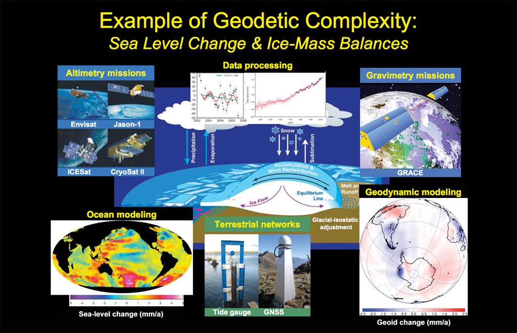


 Huntsville is the home of the original rocket scientists led by Werner von Braun, and home to the NASA Marshall Space Center and Redstone Arsenal. The city has become an extensive technology center with the Rocket Center as a focal point. If you visit, plan on a full day to see it all.