Trimble has introduced the Trimble Positions Mobile extension, a streamlined choice for integrating Trimble’s GNSS professional field solutions and data verification into the Esri ArcGIS for Windows Mobile environment.
The Trimble Positions software was first introduced as a development kit to Trimble’s GIS developer community in late 2011. Today, the software suite has expanded to provide a streamlined option for users who wish to work directly with Esri’s ArcGIS for Windows Mobile technology.
“Now, common Trimble and Esri users have a streamlined workflow between their Trimble devices and the Esri mobile software environment,” said Daniel Wallace of Trimble’s GIS Data Collection Division. “Because all data is verified and validated before it reaches Esri’s Enterprise GIS, each update adds value, making the geo-database more reliable and more useful.”
Using Trimble GNSS receivers, field workers can collect GNSS data for all feature geometries while leveraging the performance features of Trimble handhelds for improved productivity in tough GNSS environments. Data can be automatically posted to the enterprise server from the field where Trimble Positions Desktop add-in is used to process and validate the data coming in from field crews. Office administrators can check for new sessions, differentially correct the data, and verify that the data meets accuracy requirements before updating the enterprise database.
This release adds real time and postprocessed corrections support for Trimble’s GNSS receivers, including the Trimble GeoExplorer, Juno, Nomad, and Pro series receivers.
Actian Corporation has announced that Geological Data Design (GDD), a specialist in the collection, management and analysis of exploration and mining data, has selected the analytical database Vectorwise to power its Field Data Integrator. GDD’s Field Data Integrator is an end-to-end mining and exploration solution that makes working with large volumes of resource data, including GPS, faster and simpler, Actian said.
GDD’s Field Data Integrator automatically synchronizes sample data from GPS, various field instruments, and cameras onto a "tough" tablet using Bluetooth. Geologists enter notes directly onto the tablet using on-screen or wireless keyboards, enabling all data on samples to be collected automatically into a single source. The tablet then automatically synchronises with a master database running Vectorwise whenever in mobile range, saving geologists time in manual data entry.
The end-to-end solution enables geologists to collect samples in shorter time frames, and then quickly analyze large volumes of sample data for complex scenarios such as such as project timings, cash flows, and profitability with greater sensitivity levels.
“For the last 25 years GDD has been helping companies in the resource sector collect, manage, and analyze their data. Today’s technology enables us to do this more quickly and effectively,” said Tony Shellshear, principal and founder of GDD. “Geologists traditionally carry a lot of different field equipment to explore, record observations and take samples. They make notes and drawings, record coordinates, take photos, videos, or perhaps audio recordings. Collating this data can be very time consuming, and geologists can spend up to 1-2 hours a day manually entering these different information types into the database. GDD’s Field Data Integrator does all this automatically by synchronizing information from the various devices to the tablet computer, which then uploads the data to the main Vectorwise database when in reach of a wireless signal. This means geologists can spend more time collecting samples, or analysing the data, rather than being tied to the clerical work.”
While the field data collected during the day is not always large, this data often integrates into a very large database, in some cases hundreds of millions or even billions of records. GDD chose the Vectorwise database for its ability to deliver significantly faster analysis of this data on commodity hardware, Actian said.
The Topcon Tesla and the Topcon GRS-1 are compatible with ArcGIS Mobile using the new Topcon eGPS GNSS configuration utility, announced Topcon today. ArcGIS Mobile allows GIS users to deliver GIS tools and data to the field and utilize GIS data while adding accurate position and attribute information to GIS databases.
“With Topcon eGPS running on the Tesla and GRS-1, with ArcGIS Mobile you can tap into high-end GPS/GNSS receivers to easily update database accuracy and attribute information with one compact device," Jason Hooten, North American GIS sales manager, said.
Topcon’s new Tesla is a “cross-over controller for all field applications and accuracies. The Topcon Tesla has the benefits of a larger handheld screen without the heavy burden of a Tablet PC,” Hooten said.
Topcon’s GRS-1 is a 72-channel, dual-frequency L1/L2 GPS receiver with an integrated cellular modem. It can be used to dial up to a local reference station network for real-time corrections and is scalable from sub-meter to centimeter level accuracy.
“The Topcon eGPS configuration utility enables ArcGIS Mobile users to access Topcon’s full range of GPS products for any accuracy needed in the field. Now all accuracy levels are available for ArcGIS Mobile users with a simple interface,” Hooten said.
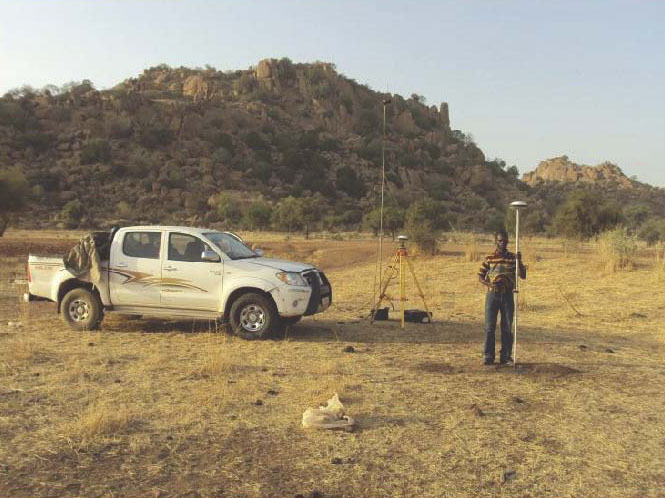
Surveyors install and configure a base and rover for a 13,000-hectare survey of the Plains Kogoni in Mali.
In the heart of landlocked Mali, between the Atlantic Ocean 800 miles to the south and the Sahara desert to the north, lays the extraordinary Inner Niger River Delta, also known as the Macina, a 1.8 million hectare oasis of lakes and floodplains with a vast potential for hydro agriculture.
CIRA, a major West African consulting engineering firm, working on behalf of the Office du Niger, a quasi-governmental Mali company charged with managing more than100,000 hectares of irrigated delta land, has completed surveying an additional 25,000 hectares for hydro-agriculture development.
Created in 1991, CIRA is an engineering and applied research consulting firm working in transportation, hydraulics, civil engineering and the environment. Based in Bamako, Mali, the firm works in more than 15 African countries, primarily in West Africa, Central Africa and East Africa.
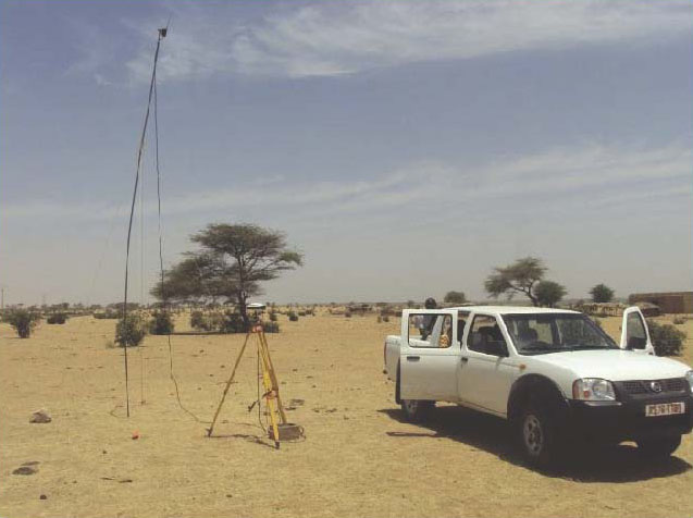
In the course of two months during the dry season, two CIRA survey teams, each equipped with three Spectra Precision ProMark 500s, a base station, and two rovers connected via UHF, completed the entire 25,000 hectare survey collecting four points in x, y, and z per hectare to produce a digital model. The model enabled the production of rough pre-study with all plans and a detailed pre-project CAD drawings for drainage, irrigation canals, and related infrastructures.
A very short eight-month contractual time set to complete the different studies meant that the land survey study would have to be completed as quickly as possible. The first thought was to use aerial photography combined with LIDAR, but setting this up would have taken too long, according to a CIRA spokesperson. Instead, CIRCA chose to employ differential GNSS, using base and rovers working in real-time kinematic. CIRA’s experience suggested the firm would achieve reliable results much quicker using only optical total stations. CIRA elected to use Ashtech ProMark 500 GNSS receivers for the project. From experience, they knew the models were easy to set up and use, lightweight, offered long battery life in the field, and field to office data transfer would be easy. Their expectations were met, and the job was completed within two months and on time.
The ProMark 500 RTK survey system provides short time to fix, long-range RTK and solution reliability. Its BLADE technology provides multi-constellation signal processing with the use of SBAS and GLONASS ranging signals to strenghten the GPS solution.
Trimble acquired Ashtech in 2011, making it part of Spectra Precision.
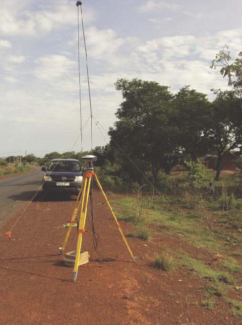
Setting up bitter points for calibration of satellite images on the corridor Sarh – Abeche in Chad (800km).Reference station during the survey topo Richard Toll road – N Dioum (120 miles) in Senegal.A reference station during the survey topo Zégoua Sikasso road (95 km) in Mali.
While the Esri Survey Summit still struggled to find a way to attract attendees, the International User Conference exploded by blowing away last year’s attendance by attracting a record 16,000+ GIS’ers this year in San Diego.
The Survey Summit reeled in only ~250 people this year along with a roomful of exhibitors. That’s not to say the content wasn’t good. On the contrary, the content was very good, as it usually is. However, state/regional conferences seem to be gearing up so it’s difficult to see how a national conference like the Survey Summit can offer enough superior content to entice people to spend a few days and a lot of dollars traveling to San Diego during prime field season.
Further complicating the issue is the fact that ACSM/NSPS is likely not going to participate in next year’s Survey Summit. But, the Survey Summit will survive because Esri will continue to sponsor it, and there’s a select few of us (yes, I’ll likely attend next year) who see the value of networking with the others who are like-minded.
Highlights of the Survey Summit
The opening ceremony featured Esri’s Donny Sosa playing the “Star-Spangled Banner” on an electric guitar.
But Donny wasn’t playing just any electric guitar. It was an Atom 3D “printed” guitar made by 3D Systems. Folks, 3D printing is going to be mind-blowing technology of the future. It will be like everyone having a machine-shop in their home/office. Design a part or a system on your home computer and manufacture it using your 3D printer (or a local 3D printing service).
Aside from the 3D printing entertainment, three subjects stuck in my head from the Survey Summit:
1. UAVs (Unmanned Aerial Vehicles) for mapping
I think the presenter from Hawkeye UAV said it best. Paraphrasing, he said that UAV commercial operations aren’t a major issue in any country besides the U.S. In the U.S., of course, commercial operations of UAVs are still prohibited. Only universities and government entities that are granted a CoA (Certification of Authorization) from the Federal Aviation Administration (FAA) are allowed to operate UAVs. The requirement for a CoA isn’t to be taken lightly, either. Last week, the Oregon Department of Fish & Wildlife was shut down from deploying a mapping UAV because its FAA paperwork wasn’t in order. They were planning to use an inexpensive RiteWind Zephyr II modified by Embry-Riddle University.
If you recall, a bill was passed earlier this year with a provision to integrate UAVs into the U.S. National Airspace System (NAS) by 2015. This is going to be a challenge for the FAA, and you can expect some pretty tight regulations being applied to UAV operations. Imagine paparazzi circling UAVs over Hollywood snapping photos of celebrity sunbathers. Some people speculate that UAV operators will be required to be licensed pilots, even if they aren’t actually flying the UAV (UAVs have pre-programmed paths they follow). The rationale is that UAV operators may need to communicate with Air Traffic Controllers to ensure there is a safe distance from other aircraft.
Although there are UAVs being designed and built specifically for mapping such as Gatewing (recently acquired by Trimble), there are an increasing number of low-cost and do-it-yourself UAVs such as Event 38 and others. In fact, I was speaking with one university researcher who operates UAVs. He said that for navigating one of his UAVs, he actually places a GPS-enabled mobile phone inside the UAV. The mobile phone, with a u-blox GPS chipset, is used to navigate the UAV as well as receive GPS corrections from mobile phone network. The only missing link from him obtaining reeeeally good accuracy was an external antenna (no such luck on a mobile phone), but he said the accuracy was still usable, and very affordable.
GPS World has published several articles lately on UAVs that you may be interested in reading.
Although I hear people say they don’t take UAVs seriously, I think it’s a serious technology with a lot of potential. Hawkeye UAV, which I mentioned earlier, says it is as busy as ever performing a lot of stockpile (volume) measurements in mines. That’s just one of many apps for this low-cost, fast, and easy-to-deploy technology.
2. 3D Rendering Technology
I’ve written before about 3D rendering technology; remember this cool Ted video? It’s worth watching.
Last year, Esri acquired a company called Procedural, which is the developer of a product named City Engine. It’s a really neat tool for “building” a city, from scratch if you wish, to help people visualize (in 3D) what a proposed development would look like. I’ve done similar things in the past with Autodesk’s 3D Studio Max, but City Engine seems to be a more quick-and-dirty, GIS-centric tool. Take a look at the following video on how to build a city from scratch into a complete 3D visualization:
3D visualization tools have been progressing slowly over the years, but I think it’s getting to the point that without a lot of expertise, one can generate high-quality 3D visualizations. The trend is clear. If you recall, Trimble acquired Sketchup from Google earlier this year to incorporate a 3D visualization toolset inside its software. Geospatial specialists are getting closer and closer to being able to produce video-game-quality 3D renderings for visualizing everything from land development to regional watersheds and environmental impact areas. It’s a fantastic tool for presenting rich, complex geospatial data to the general public.
3. The Cloud
Ok, cloud-based apps aren’t anything new. In fact, I’m writing this article using a cloud app. Microsoft has had a cloud version of Office apps for years.
It seems Esri has retooled its entire corporate strategy around cloud-based apps and data. It’s not just www.arcgis.com, Esri’s new cloud app for GIS, or ArcGIS for Android/iOS/Windows Mobile for mobile devices. According to Esri president Jack Dangermond, Esri has spent “tens of millions” on acquiring/licensing content (data) for cloud users. It’s not just vector data either (roads, etc.). In the U.S. arcgis.com subscribers will have access to nationwide 30-cm resolution imagery. In Europe, subscribers will have access to 60-cm resolution imagery, while subscribers in the rest of the world will have access to 1-meter imagery.
The upside of cloud apps is that users can offload the IT overhead part of GIS, which can be frightenly expensive and complex. It also makes GIS apps easier to deploy because there is no client software to install or maintain on users’ computers.
However, cloud GIS is not the solution to every GIS challenge. Even Esri president Jack Dangermond openly stated last week that “You don’t have to buy this, but you should,” referring to arcgis.com. But make no mistake about it, he’s clearly pointed the Esri ship to the cloud. My gut tells me that with arcgis.com, Esri will be successful in introducing GIS apps to a much broader audience, seemingly in line with Dangermond’s vision that eventually GIS will evolve from a scientific tool to a tool used by general society.
Courtesy: ESRI
On the subject of bringing GIS tools to to general public, Esri announced Esri Maps for Office, which Esri describes as an analytics tool to “visualize data by creating and sharing interactive maps directly within Microsoft Office.” In other words, make maps based on your Excel (or other Office) data. Take a look at the video below to gain an understanding of what Esri is talking about.
If you’d like to see some brief comments that I tweeted from the Survey Summit on some other interesting items, click here for a quick summary. In next week’s newsletter, look for my summary on the Esri User Conference.
The U.S. Census Bureau released a new online service that makes key demographic, socio-economic and housing statistics more accessible than ever before. The Census Bureau’s first-ever public Application Programming Interface (API) allows developers to design Web and mobile apps to explore or learn more about America's changing population and economy.
According to the announcement, the new API lets developers customize Census Bureau statistics into Web or mobile apps that provide users quick and easy access from two popular sets of statistics:
2010 Census (Summary File 1), which includes detailed statistics on population, age, sex, race, Hispanic origin, household relationship and owner/renter status, for a variety of geographic areas down to the level of census tracts and blocks.
2006-2010 American Community Survey (five-year estimates), which includes detailed statistics on a rich assortment of topics (education, income, employment, commuting, occupation, housing characteristics and more) down to the level of census tracts and block groups.
The Census Bureau reports that the 2010 Census and the American Community Survey statistics provide key information on the nation, neighborhoods and areas in between. By providing annual updates on population changes the survey helps communities plan for schools, social and emergency services, highway improvements and economic developments.
“We hope to see many apps grow out of the Census API, as this opens up our statistics beyond traditional uses,” Census Bureau Director Robert Groves said. “The API gives data developers in research, business and government the means to customize our statistics into an app that their audiences and customers need.”
For example, developers could use the statistics available through this API to create apps that:
Show commuting patterns for every city in America.
Display the latest numbers on owners and renters in a neighborhood someone may want to live in.
Provide a local government a range of socioeconomic statistics on its population.
“Apps give people simpler access to our statistics so they can get the information they need to answer questions or solve problems,” said Stephen Buckner, chief of the Census Bureau's Center for New Media and Promotions. “As Web developers exercise their creativity with our statistics, we believe the public will gain more opportunities to access more of our information on their laptops and mobile devices — anytime and anywhere they wish.”
The Census Bureau announced it has also launched a website for developers to provide feedback and ideas on the API. The website includes an “app gallery” where the public can view and download Web apps that have already been created:
Age Finder — Users have the flexibility to get a count of the population for a single year of age or for a customized age range by sex, race and Hispanic origin for states, counties and places.
Poverty Status in the Past 12 Months by Sex by Age — Users can get the poverty rate for counties in New York by sex and multiple age groups in an app developed by the Program on Applied Demographics at Cornell University.
With the release of this API and other upcoming forward-looking online communications improvements, the Census Bureau is meeting the goals of the President's digital strategy to make information more transparent and customer-centered.
Editor’s note from the Census Bureau: The API does not include any information that could identify an individual; such information is kept strictly confidential by law. The API only uses statistics that the Census Bureau has already released publicly and in aggregate form.
Trimble has announced that the Trimble GCSFlex Grade Control System for Excavators now offers highly accurate GPS machine guidance via Wi-Fi. By serving GPS corrections over a Wi-Fi connection from a local base station, Trimble has eliminated the need for a radio network on the construction site and made it easier than ever to deploy GPS for a broad range of excavation work, the company said.
Trimble introduced GCSFlex Grade Control System for Excavators in 2011 as an affordable, easy-to-use machine control system for owner operators and small to mid-sized contractors who want to increase their productivity and competitiveness. With several system configuration options available, contractors can select the sensor options that fit their job site needs at a price point that fits their budget.
The new configuration of GCSFlex is deployed with the innovative Trimble SPS985 GNSS Smart Antenna as a local base station for transmitting GPS corrections to the excavator. The operator needs only to position the Trimble SPS985 base station and power it on to automatically establish a Wi-Fi connection and begin broadcasting corrections to the machine. With simplified daily setup and operation, Trimble has made the highly powerful GCSFlex system easy to deploy and use, even for excavator operators with little or no experience with machine control.
GCSFlex with GPS Guidance also offers the benefit of using in-field design templates created directly from the cab on the Trimble CB450 Control Box. This allows the excavator operator to very accurately dig to a desired depth, slope or alignment without creating a digital design in the office.
Trimble announced a new UHF RFID Reader accessory for its Nomad rugged handheld computer.
The Trimble ThingMagic Reader supports reading and writing of EPC Global Gen2 tags which are commonly used for asset and inventory management. The UHF RFID Reader accessory is designed to withstand drops, vibration, humidity, extreme temperatures and immersion, making it ideal for challenging environments.
"The Nomad has been a very successful rugged mobile platform, supplying field workers with a robust tool for data capture and navigation," said Jim Sheldon, general manager of Trimble's Mobile Computing Solutions Division. "The RFID Reader further extends the Nomad's capabilities and offers enterprise management more options in its use."
"Similar to the widespread integration of GPS into today's positioning solutions, we believe RFID is a natural complement to many asset management applications and Trimble solutions," said Tom Grant, general manager of Trimble's ThingMagic Division. "Integrating high-performance RFID technology into high-value products like the Nomad delivers a strong platform for next generation productivity applications."
The UHF RFID Reader is available in two variations: one for use in Europe, and the other for use in the U.S., Canada and most of South America. The Reader is based on the best-in-class ThingMagic M5e Compact UHF RFID module, and includes device drivers and a Software Development Kit to enable systems integrators to add RFID capabilities to their mobile applications.
Topcon Positioning Systems (TPS), announces the release of a new mobile GIS field software – eGIS.
According to the announcement, eGIS is compatible with Topcon’s FC-25, FC-236, Tesla and GRS-1 controllers, and makes all accuracy capabilities from autonomous measurements to RTK centimeter level accuracy easy to achieve. The new software makes it easy to collect and maintain databases for a variety of uses – electric utilities, gas pipelines, disaster management, water and wastewater operations, forestry, highway maintenance, environmental studies, as well as other mapping projects.
Jason Hooten, TPS national sales manager for GIS products, said, “As applications for GIS data collection continue to expand, we are pleased to offer an easy-to-use field software solution. The customization and graphical interface aspects of this software make it very simple to collect, view, download and export GIS data.”
Key features of eGIS include:
• ESRI compatible (Native Shapefile format);
• Fully integrated GRS-1 GNSS functions;
• Capture, edit, analyze and display geographic information;
DeLorme today announced at the Esri Users Conference the introduction of ArcSync, a software engine that allows customers to transfer field data edits to Esri repositories and synchronize field databases with the internal GIS database.
ArcSync automates the process of defining and scheduling tasks, providing automatic data flow and keeping field and office databases in sync.
“The ArcSync engine is an automated tool that streamlines the synchronization between field data collection and the ArcGIS database at headquarters,” said John Auble, DeLorme vice president, data products and HA/DR programs. “It is the ideal solution for organizations with a need to collect and distribute GIS data to field personnel in a disconnected format. It creates disconnected GIS layers from ArcGIS feature classes and maintains synchronization as changes are made via DeLorme, ArcMap, or other Esri tools.”
Auble noted that ArcSync permits the GIS Admin to ensure data viewed in the field is current for both the connected and disconnected GIS user, pushing work tickets to field personnel in an automated fashion so that critical data can be collected in a timely manner. It also allows for a scheduled automated process to run in order to make sure that all databases are in sync, eliminating the need for GIS Admin to spend time processing files manually to keep the field database and internal GIS database synchronized.
DeLorme is showcasing its full range of mapping, positioning and tracking solutions in Booth 2407 at the 2012 Esri Users Conference this week in San Diego.
Altus Positioning Systems has made three announcements at the Esri 2012 Users Conference in San Diego this week. The company introduced a new GPS-based data-acquisition system for the GIS industry, introduced a portable integrated system for GIS applications, and announced the commercial availability of a GNSS receiver.
New GIS system. Altus introduced a new GPS-based data-acquisition system for the GIS industry. The new system from Altus includes an ikeGPS multi-sensor data-acquisition system and a variety of built-in software tools for specific data-collection projects.
The ikeGPS product combines a GPS receiver, laser rangefinder, 3D compass and digital camera in a single ruggedized handheld device, providing a fully integrated low-cost solution for capturing geospatial data and 3D GIS imagery. The versatile system permits the user to geolocate objects quickly and easily from a single location with the laser rangefinder and compass, using the recorder’s GPS coordinates as a reference. The digital camera provides a visual reference for each object captured into the database, and the system can even calculate position coordinates for target items directly from the photographs.
“The ikeGPS multi-sensor platform enables the capturing of GIS data in situations that would be otherwise impossible using traditional GIS equipment,” said Neil Vancans, CEO and president of Altus Positioning Systems. “The ikeGPS mobile GIS solutions provide unique improvements on conventional GIS data-collection efficiency. It also enables the user to capture accurate measurements of remote objects — for instance, across a busy highway, barbed-wire fence, or stream — from safe distances with its point-and-shoot capability, producing verifiable, geo-referenced data collection.”
Vancans noted that for applications requiring higher-precision positioning, the ikeGPS device can be interfaced with Altus’ APS-3 GNSS RTK survey-grade receivers for centimeter-level accuracies.
Portable Integrated System for GIS Applications. Altus also introduced the new ProCyon, which integrates the flexible, rugged Psion Workabout Pro handheld computer with Altus’ APS-3 RTK GNSS receiver for a powerful GIS data-acquisition platform, the company said.
The ProCyon system delivers one-centimeter RTK accuracy using an external antenna, integrated camera, and quad-band GSM modem. Additionally, the ProCyon has hardware expansion slots, making the addition of new modules fast and easy, as well as a range of available add-ons, including fingerprint scanners and the largest selection of RFID readers on any handheld device, Altus said.
The ProCyon Windows Mobile operating system accommodates ESRI ArcPad and ArcGIS applications. Both programs use NMEA messages that are standard outputs from the integrated GNSS receiver in the ProCyon.
“The ProCyon is built on the industry-standard platform of the Psion Workabout, one of the world’s top-selling Windows Mobile devices,” said Neil Vancans, CEO and president, Altus Positioning Systems. “The ProCyon is an answer to the needs of many utilities already using Psion products.”
Commercial Availability of GNSS Receiver. Altus Positioning Systems also announced the commercial availability of its new APS-U GNSS receiver. For maximum flexibility, the APS-U is scalable from a single stand-alone GNSS receiver to full options with heading, wireless links, precise point positioning, and RTK capability. The unit has an additional processor for on-board configuration and custom applications separate from the GNSS engine. It has an extensive suite of interfaces for data output, timing, event marks and a second antenna port for GNSS heading.
“The APS-U provides multi-frequency capability together with GNSS heading, L-Band positioning and wireless communications, all within a hardened housing that meets military environmental specifications,” said Neil Vancans, CEO and president, Altus Positioning Systems. “With its wide range of interfaces and 9-30V power input options, the APS-U is an ideal GNSS solution for GIS data collection as well as machine control, agriculture, aerial photogrammetry, heading sensors and military applications. It can also be used in a variety of different formats, without heading information, in a robust receiver or base station configuration.”
The 136-channel receiver is designed to use all GPS, GLONASS, and Galileo frequencies. Integrated wireless options include Bluetooth for easy configuration, plus a GSM or CDMA cellular modem and UHF radio modem for transmission and reception of RTK corrections. It also works with WAAS, EGNOS, and other satellite-based augmentation systems.
The rugged new APS-U units incorporate Septentrio GNSS receiver engines, and meet MIL-STD-810G specifications for humidity, dust, shock, and vibration, and operates under temperatures from 30 to minus 65 degrees Celsius.
DeLorme announced the introduction of ArcSync, a software engine that allows customers to transfer field data edits to Esri repositories and synchronize field databases with the internal GIS database.
ArcSync automates the process of defining and scheduling tasks, providing automatic data flow and keeping field and office databases in sync.
“The ArcSync engine is an automated tool that streamlines the synchronization between field data collection and the ArcGIS database at headquarters,” said John Auble, DeLorme vice president, data products and HA/DR programs. “It is the ideal solution for organizations with a
need to collect and distribute GIS data to field personnel in a disconnected format. It creates disconnected GIS layers from ArcGIS feature classes and maintains synchronization as changes are made via DeLorme, ArcMap or other Esri tools.”
Auble noted that ArcSync permits the GIS Admin to ensure data viewed in the field is current for both the connected and disconnected GIS user, pushing work tickets to field personnel in an automated fashion so that critical data can be collected in a timely manner. It also allows for a scheduled automated process to run in order to make sure that all databases are in sync, eliminating the need for GIS Admin to spend time processing files manually to keep the field database and internal GIS database synchronized.


 Portable Integrated System for GIS Applications. Altus also introduced the new ProCyon, which integrates the flexible, rugged Psion Workabout Pro handheld computer with Altus’ APS-3 RTK GNSS receiver for a powerful GIS data-acquisition platform, the company said.
 Commercial Availability of GNSS Receiver. Altus Positioning Systems also announced the commercial availability of its new APS-U GNSS receiver. For maximum flexibility, the APS-U is scalable from a single stand-alone GNSS receiver to full options with heading, wireless links, precise point positioning, and RTK capability. The unit has an additional processor for on-board configuration and custom applications separate from the GNSS engine. It has an extensive suite of interfaces for data output, timing, event marks and a second antenna port for GNSS heading.