A government-sponsored survey has set out to find the highest peak in Bangladesh. Field teams for the Survey department under the Ministry of Defense have begun field work in the remote hill areas of Ruma and Thanchi upazilas in Bandarban district.
The survey, taking place April 4-12, will use modern geodetic methods and advanced GNSS technology. The surveyors will follow international standards to determine the height of the country’s highest peak above mean sea level (MSL) with centimeter-level accuracy, including latitude, longitude, and elevation.
Through the use of a newly developed geoid model, it will be possible to accurately convert ellipsoid heights obtained from GNSS receivers into mean sea level (MSL) elevations of the mountain peaks, according to the government.
The survey is expected to resolve the long-standing debate over whether Tajingdong, Keokradong or Saka Haphong is the country’s highest mountain peak.
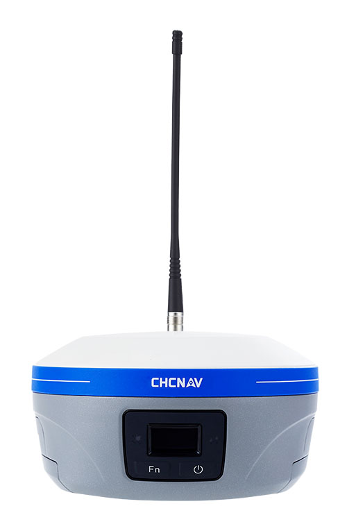
CHC Navigation has announced major updates to its i93, i85 and i76 GNSS receivers, as well as the iBase professional base station. The updates are designed to further improve positioning stability, simplify field setup, and expand operational capability across demanding surveying environments.
Enhanced RTK performance with the CHCNAV StellaX GNSS chip The updated i93, i85 and i76 receivers integrate the CHCNAV StellaX GNSS chip with multi frequency signal tracking and advanced anti interference mitigation. This design is intended to support more reliable GNSS RTK positioning and more consistent data collection in complex terrain and in areas with partial GNSS satellite visibility.
PointSky GNSS corrections service for remote surveying To reduce reliance on cellular networks and local radio links, the updated i93 and i85 now include a one-year standard subscription to the CHCNAV PointSky service. PointSky delivers GNSS corrections via satellite, enabling users to reach a 2.5 cm precision fix in three to five minutes. This capability supports surveying operations in remote locations such as mountains, forests and deserts where network coverage can be limited or unavailable.
Longer range radio operation and simplified iBase startup The iBase base station now integrates CHCNAV DistLink technology and improved data compression to increase radio sensitivity and support up to 30 km coverage for linear projects such as highways and railways. Power consumption has also been optimized to support more than 13 hours of continuous operation without external batteries. To streamline setup, iBase includes a one button startup sequence designed to automatically pair with rover units, reducing the need for manual parameter configuration in the field.
In my February GPS World newsletter, I highlighted that the National Geodetic Survey (NGS) staff participated in GeoWeek 2026 in Denver. They engaged with geospatial product and service users and provided the latest updates on the status of the modernization. On March 25, 2026, as President of American Association for Geodetic Surveying (AAGS), I participated in a GeoWeek webinar titled “NSRS Modernization is Here: What Surveyors Need to Know Now.”
The webinar was based on presentations by NGS and others at GeoWeek 2026. The webinar provided the status of NGS’s new modernized NSRS and the professional societies (AAGS, ASCE, ASPRS, and NSPS) addressed how they are helping others to prepare for the change. It is available to everyone under the “On-Demand Webinars” section of Geo Week News here: https://www.geoweeknews.com/webinars.
First, at the end of February’s newsletter, I shared my main thoughts and concerns that I believe NGS and the broader community should carefully consider before NGS adopts the new modernized NSRS.
I encourage you to watch the GeoWeek Webinar mentioned above for the latest update from NGS on the modernized NSRS.
I have already shared my concerns directly with NGS, but it’s important that they also hear from the user community. You can provide feedback via [email protected], user forums, or upcoming webinars and Q&A sessions.
Although I covered these points in my last newsletter, I believe they remain important, so here’s a shorter version of my key thoughts and concerns:
Timeline uncertainty: Clearer, more frequent milestone updates (beyond the Track Our Progress page) would help manage expectations.
OPUS and processing continuity: NGS should commit to a longer grace period — or ideally a defined parallel support window — for legacy OPUS tools (particularly OPUS-Projects 5) after the official adoption of the modernized NSRS.
Data access and usability in the new DDS: The new web-based system needs to provide robust APIs or export options that are comparable to those in current datasheets/legacy tools.
Transformation tools and legacy data handling:Users need confidence that transformations minimize errors, especially in deformation-prone areas.
Communication and outreach: Case studies, training resources, and FAQs that describe real-world practical examples, tailored to common workflows, need to be developed and documented.
Again, I encourage anyone reading this (including NGS staff) to test the beta products actively, submit detailed feedback, and participate in forums/Q&As. The community input will make or break the success of this once-in-a-generation update
Regarding the 2026 Society of Land Surveyors of Iowa (SLSI) Annual Meeting, I was grateful to receive the invitation and truly enjoyed attending. As always, I came away from this gathering of surveyors with valuable insights.
The conference was exceptionally well organized, with plenty of time for meaningful interactions among attendees, exhibitors, and speakers. In total, 285 people attended.
As expected, I presented on the new modernized NSRS. The topics I covered are listed in the box titled “Topics Addressed During my ½ Day Session on the New NSRS.”
I was fortunate to have Ben Sullivan, Seiler Geospatial, set the stage for my presentation by providing a short introduction to the new modernized NSRS. He provided an overview that addressed: (1) what the new national datum is, (2) how it will affect the geospatial community, and (3) how users can prepare for it once officially released by the NGS.
Topics Addressed During My Half-Day Session on the New NSRS
What to expect between NAD 83 (2011) and NATRF2022 in Iowa?
Why is NGS modernizing the NSRS and what are the expected coordinate changes in Iowa?
How are reference frames and datums defined?
What are the differences in CORS coordinates between the Multi-year CORS Solution 2 (MYCS2) and Multi-year CORS Solution 3 (MYCS 3) in Iowa?
What does NGS mean by time-dependent coordinates and why is it necessary for the new, modernized NSRS?
How will plate tectonics be handled in the new, modernized NSRS?
What’s the difference between NAD 83 (2011) epoch 2010.0 and NATRF2022 epoch 2020.0 in Iowa?
What are the differences between Reference Epoch Coordinates (REC) and Survey Epoch Coordinates (SEC)?
What’s the difference between ITRF2020 and NATRF2022 in Iowa?
How do you use NCAT to convert between reference frames and compute State Plane Coordinates?
Why is it important to have the appropriate metadata of your old projects for the implementation of the new, modernized NSRS?
What to expect between NAVD 88 and NAPGD2022 in Iowa?
How will orthometric heights be determined in the new, modernized NSRS; that is, how will NAPGD2022 orthometric heights be determined in the new NSRS?
Review of Computing GNSS-Derived Heights
What’s the estimated difference between NAVD 88 and NAPGD2022 epoch 2020.0 in Iowa?
How will NAPGD2022 Orthometric heights be determined using GEOID2022?
What are the differences between GEOID2022 models and Hybrid Geoid Model GEOID18 in Iowa?
How will NAPGD2022 affect the National Flood Insurance Program and the Elevation Certificate?
Updates from the National Geodetic Survey at GeoWeek 2026
Many of the topics covered in my session have been addressed in previous newsletters. For example:
My June 2020 newsletter explained how NAPGD2022 orthometric heights will be determined using GEOID2022, and why NGS will require GNSS occupations on primary marks when submitting leveling projects.
Whenever I attend conferences, I visit exhibitors to ask about the modernized NSRS. Many had heard of it, but only a few could explain the differences or how their company will adapt products and services to the new reference frames. Several said their company is aware of the change but couldn’t specify how or when they’ll respond. I encourage all users to contact their equipment and software providers and request a detailed plan for addressing the new NSRS.
I want to highlight two sessions I found both very interesting and important for surveyors. They were presented by Todd Horton, PE, PLS of Meridian Geospatial.
Meridian Geospatial Consulting Todd Horton, PE, PLS, is the owner of Meridian Geospatial Consulting, LLC. Todd has provided technician training and continuing education seminars for the land surveying industry since 2005. Todd served in the US Air Force and with the Illinois Department of Transportation in planning, design, construction, surveying and maintenance of civil engineering projects including commercial structures, airfields, utility systems and highways. He joined the full-time faculty at Parkland College in Champaign, IL, where he taught land surveying and construction management courses for 25 years. Todd founded the land surveying associate degree program at Parkland College in 2001. Having retired from full-time teaching, Todd has joined Farnsworth Group Inc. as a part-time senior project land surveyor. You can reach him at [email protected]. (From https://www.meridiangeospatial.com/)
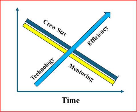
One of Horton’s presentations was titled “Professional Ethics.” In it, he highlighted how new technology is reducing the size of surveying crews and improving overall efficiency. However, this comes at the cost of reduced opportunities for mentoring the next generation of survey technicians and surveyors.
I’ve recreated his diagram below to illustrate the issue.
Crew Size vs. Mentorship
Crew vs Mentorship. (Recreated from Todd Horton’s presentation)
As shown in Horton’s diagram, while new technology increases efficiency and allows for smaller survey crews, it also reduces the time available for surveyors to mentor technicians and the next generation of professionals.
Training and mentoring are extremely important for the continued growth and development of individuals in the surveying and mapping community.
He explained that the world consists of two types of individuals: specialists, who have a narrow skill set and limited opportunities, and generalists, who possess broader knowledge and skills, think multi-faceted, and are forward-looking.
He emphasized that a professional surveyor typically needs 3 to 5 surveying technicians to successfully complete a project. While professional surveyors regularly attend training sessions (as evidenced by many participants at this conference), technicians often have little or no access to formal training.
He advocated that technicians should be trained as generalists. This means equipping them not only with better tools and equipment, but also with a strong foundational knowledge and skill set — especially understanding the “why” behind the “how.” This deeper knowledge enables them to prevent problems before they occur and effectively troubleshoot issues when they arise.
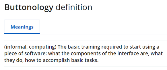
I addressed this same concern in my November 2022 newsletter, where I warned that the industry is creating a growing number of “buttonologists” — technicians who rely heavily on pushing buttons without deeper understanding.
This trend concerned me then, and it still does today. That’s why I was especially pleased to hear Todd directly address the issue and offer a clear path forward for improving training and development for both technicians and surveyors.
A participant at one of my workshops stated that “GPS has made geodesists out of all of us.” In my opinion, the advancements in GNSS equipment and processing software provided some users with a “false sense of knowledge or security” that they understood what was happening within the “black box.” One of my colleagues at NGS said that the new equipment and software programs were creating a field force of “buttonologists.”
He highlighted that the surveying community needs more technicians than licensed professionals. As a result, we should prioritize training and development for technicians. This is a constant need and would help reduce turnover rates.
He also emphasized the importance of growing future professionals from within the technical ranks. Doing so would increase technicians’ motivation and desire for advancement, making them more eager to take on greater responsibility and pursue professional growth.
He provided the following training approaches:
On-the-job training
Self-guided study
Continuing education resources
Online content
College courses
Live skill training
He noted that these investments in training will yield the following advantages in professional and organizational development:
Enhanced employee skills
Opportunities for career advancement
Stronger organizational performance
Sustained competitiveness via continuous learning
Increased productivity
Higher employee retention
A thriving culture of innovation
Horton also discussed a training program he’s involved in that not only trains technicians but also includes training for the trainers. This “train-the-trainer” approach helps accelerate the program’s growth and impact.
For more information, I encourage you to reach out to Horton directly for additional details about his programs and his ideas on improving technician training.
Horton also gave a very good session on a very difficult subject, that is ALTA/NSPS “Relative Positional Precision (RPP).”
As a side note: see the box titled “Top 5 Key Changes in the 2026 ALTA/NSPS Standards” for the key changes in the 2026 ALTA/NSPS standards. Detailed information on the ALTA/NSPS 2026 document can be downloaded at the following NSPS weblink: https://nsps.us.com/page/2026ALTA.
Precision (RPP): The clarification of RPP is a core technical change. While it does not alter how surveys are performed, it improves consistency and understanding of measurement quality expectations across the profession.
Shift from “on the ground” to “practices generally recognized as acceptable” (Sections 5 & 6): This is one of the most significant forward-looking changes. It explicitly accommodates modern technologies such as drones, lidar and future tools (including AI), without locking the standards to specific methods.
Expanded guidance on sourcing title evidence when a recent title commitment is unavailable: This change directly affects research responsibilities and risk management, especially on projects where title information is incomplete, delayed, or unconventional.
Requirement to note evidence of possession or occupation along the entire perimeter: This materially broadens what must be considered and documented in the field, regardless of how close that evidence is to the boundary line – an important title-risk issue.
Clarification that verbal (“parol”) statements must be noted when made: This adds explicit documentation requirements tied to conversations with landowners or occupants, which can be critical in dispute resolution and liability defense.
Todd started his presentation by providing RPP as defined by ALTA/NSPS (2026):
Relative Positional Precision (RPP) is the acceptable indicator of measurement quality on an ALTA.NSPS Land Title Survey.
It is defined as the length of the semi-major axis, expressed in meters or feet, of the error ellipse of the line connecting the monuments or witnesses marking adjacent boundary corners of the surveyed property at the 95 percent confidence level.
His session was organized into nine sections labeled RPP Keys for Success:
Choose one equipment and a measurement method based on the accuracy needs of the project.
Use well-adjusted instruments and procedures to eliminate systematic errors in measures.
Make internal checks to detect blunders in measurements.
Make redundant measurements to have a large degree of freedom.
Access the quality of control that will be used.
Avoid weak network geometry.
Organize all field measurements for software input.
Establish standard errors for all observation conditions.
Adjust and analyze results.
In these sessions, he covered fundamentals including:
precision vs. accuracy,
systematic vs. random errors, and
absolute vs. relative accuracy.
Horton emphasized that systematic errors follow mathematical or physical laws and can usually be modeled or reduced with proper procedures, while random errors persist after blunders and systematic errors are addressed. By using improved equipment and proper procedures to detect, reduce, or remove errors, users lower the uncertainty in their results — reducing uncertainty should be a goal for any product or service.
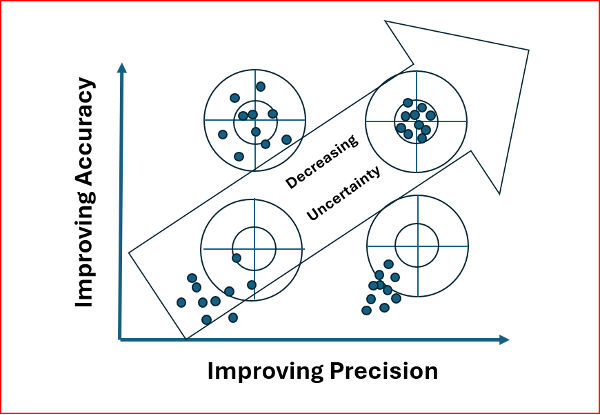
Many people are familiar with the classic bow-and-arrow (or target) diagram that illustrates the difference between precision and accuracy.
I recreated Horton’s diagram on this topic because it effectively highlights that our ultimate goal in surveying is to reduce uncertainty in our results.
As the diagram shows, simply repeating observations can give the appearance of good precision, but it does not guarantee accuracy. The result can be high precision with low accuracy — and therefore a large remaining uncertainty.
Precision vs. Accuracy
Recreated from Todd Horton presentation
Todd noted that most RPP values are derived from a properly weighted least-squares adjustment. Many manufacturers’ software packages now use least squares to estimate RPP, making it essential to provide accurate error estimates so the data are correctly weighted in the adjustment.
To illustrate this point, he provided clear examples of the following concepts:
Determining the appropriate error estimates for data,
Measuring errors,
Degrees of freedom and redundancy,
Significance and confidence intervals,
Appropriate weights of measurements,
Propagation of errors, and
Statistical tests for analysis of data and results.
He explained how to compute the allowable RPP and offered practical advice on selecting the appropriate equipment and measurement methods, tailored to the accuracy requirements of the project.
In my opinion, this topic can be challenging to grasp without a strong mathematical background. Todd did an excellent job explaining the concepts clearly while avoiding excessive mathematical detail.
To illustrate the RPP, Todd presented two real-world examples of combined networks using GNSS and traverse data. The first example combined GNSS with an open traverse using EDM, horizontal, and zenith angles. The second example incorporated RTK GNSS vectors with a closed traverse using classical survey data.
This was an excellent session. I highly recommend reaching out to Todd for more details about his programs and insights.
I want to thank the organizing committee of the 2026 SLSI Annual Meeting for the kind invitation to participate in their conference. I truly enjoyed the experience and came away with many valuable insights from this excellent gathering of surveyors.
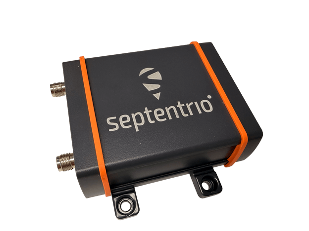
Septentrio, part of Hexagon, offers a new enclosed multi-frequency GNSS receiver: AsteRx EB.
The cost-effective product offers uncompromised high-accuracy positioning and GNSS heading for industrial robots, port logistics, marine, and scalable automation applications. Its IP67 enclosure protects the receiver from harsh weather conditions, while built-in advanced GNSS+ algorithms ensure reliable operation in environments that are challenging for GNSS, such as areas with foliage or near GNSS interference sources.
The RAIM+ integrity monitoring system ensures truthful positioning, which is essential for autonomous navigation. The compact enclosure of AsteRx EB enables easy installation, reducing time-to-market.
“AsteRx EB is an ideal boxed receiver for customers who need reliable, resilient, and highly accurate positioning in a compact form factor and at a price point that makes rapid scale-up possible,” said Danilo Sabbatini, Product Manager at Septentrio, part of Hexagon.
In a dual-antenna configuration, AsteRx EB delivers sub-degree GNSS heading for systems that require orientation in addition to RTK positioning. The built-in AIM+ anti-jamming and anti-spoofing technology protects the receiver from intentional or unintentional GNSS interference.
AsteRx EB extends Septentrio’s lineup of enclosed GNSS receivers. Like mosaic-go, it can be used for quick and easy testing or evaluation of Septentrio’s reliable positioning technology. Thanks to its robust housing, it can be deployed in a wide range of industrial applications. For systems exposed to very harsh weather conditions or intense mechanical stress, the AsteRx RB3 ultra-rugged receiver provides the highest level of protection.
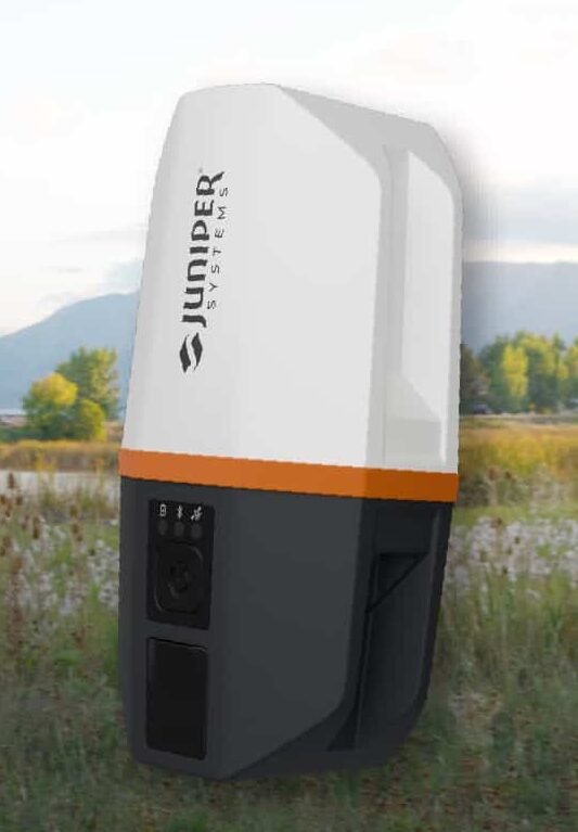
Juniper’s newest GNSS receiver, the Juniper Spire, is designed to simplify location data collection. With the Spire, users can achieve high-accuracy results with a light, compact design, one-button operation, and corrections services right out of the box.
Built for rugged environments and long workdays, it offers seamless integration with mobile devices and data collection apps, making it a reliable companion for all GIS and asset mapping applications.
It is designed for work in both remote areas and urban settings, and supports SBAS, Network RTK, and future correction services. Gather meter to centimeter-level data with our most forgiving antenna. With fast satellite acquisition, multi-constellation tracking, and extended battery life, it delivers consistent performance across a wide range of applications—from environmental monitoring to utility inspections.
Key features include:
Accuracy down to the 2cm range
Worldwide corrections with SBAS, RTK, and future compatibilities
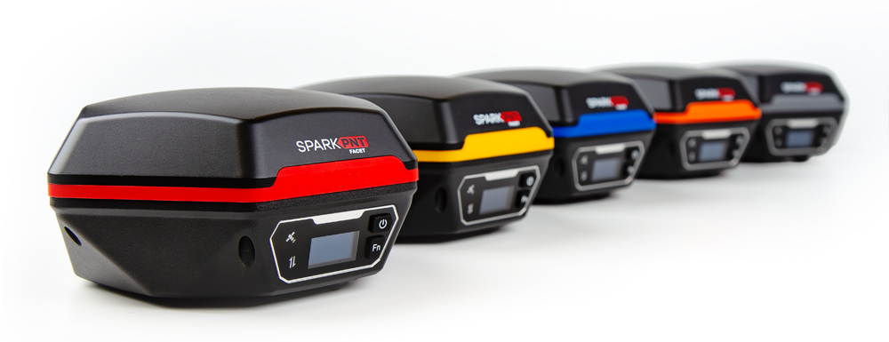
SparkPNT has released the SparkPNT Facet FP, a high-precision GNSS receiver designed to deliver centimeter-level accuracy with a focus on long-term flexibility, ease of use, and open-source innovation.
Built for a rapidly evolving positioning landscape, the Facet FP combines multi-band, multi-constellation GNSS support with fully open-source firmware — giving users a platform that can adapt as technologies continue to advance. Built to last, all models are contained in a robust waterproof cast-aluminum housing, with an internal structure designed for compatibility with the company’s Flex system of GNSS modules.
This gives users the choice between three different modules, plus the choice of having tilt-compensation or not, offering six different options with a range of price-points, securities and accuracies for different needs and applications.
Other notable features include:
MFi Certification
LoRa radio with detachable antenna
Internal survey-grade L1/L2/L5/L6 GNSS antenna
IP-67 rated housing that blocks out dust, water and other environmental hazards
Hemisphere GNSS, a brand of CNH, together with Calian Group Ltd, have released the A65 GNSS antenna, a jointly developed, next-generation solution engineered to deliver exceptional accuracy, superior interference protection, and robust GNSS tracking performance.
The A65 is designed as a drop-in replacement for the widely deployed A45 antenna, offering users a seamless upgrade path to the latest precision technology.
The collaboration reflects a shared focus on combining advanced RF design with real‑world application insight to address increasingly complex GNSS operating environments, with both teams working closely from the earliest stages of development to meet demanding original equipment manufacturer (OEM) performance requirements.
The antenna architecture itself, including the stacked patch quad feed element and RF front end, was engineered by Calian, and provides Calian’s XF Filtering. Hemisphere GNSS contributed application expertise, system integration requirements, and performance validation within real-world machine control, agriculture, marine and survey environments.
The result is a precision antenna that delivers:
outstanding multipath suppression
highly consistent phase center variation
accurate tracking across GPS (L1/L2/L5), Galileo (E1/E5/E6), BeiDou (B1/B2/B3), GLONASS (G1/G2/G3), NavIC L5, QZSS, and L-band correction services
lower power consumption and broad voltage compatibility
Together, Hemisphere and Calian ensured the A65 meets demanding field requirements while exceeding the performance benchmarks of the A45.
Calian XF Filtering for Interference Rejection
A major advancement of the A65 is the integration of Calian’s XF Filtering. The interference mitigation system rejects out-of-band energy at the antenna level, significantly improving signal quality in RF-challenging environments.
Calian XF Filtering provides protection against:
4G / 5G cellular transmissions
Ligado and adjacent band interference sources
broadband marine and aviation systems
industrial and urban RF noise
By combining Calian’s advanced filtering technology with Hemisphere GNSS’s application-level expertise, the A65 delivers cleaner signals, improved reliability, and more stable performance in harsh real-world environments.
Engineered for rugged field use
Validated through Hemisphere GNSS field testing and Calian engineering qualification, the A65 includes:
IP69K environmental protection
High-impact LEXAN radome and robust metallic base
Low noise amplifier (LNA) with high gain (2.5 dB NF, 28-30 dB gain)
15 kV electrostatic discharge (ESD) protection
-40°C to +85°C operating range
These specifications are designed to ensure the A65 provides long-term performance across agriculture, survey, machine control, marine and fixed-reference installations.
The A65 GNSS antenna is available now through Hemisphere GNSS. OEM module versions based on the same Calian engineered design are also offered for integrators requiring embedded solutions.
Digital Mapping Group, a pioneer in high-accuracy GNSS solutions for more than two decades, has released FastXY, a powerhouse mapping application for iOS and Android.
FastXY is designed to transform standard mobile devices into professional-grade data-collection tools for geospatial information system (GIS) and architecture, engineering and construction (AEC) professionals.
As the industry shifts away from bulky, proprietary hardware, FastXY offers professionals the ability to collect point, line and polygon data with the devices already in their pockets. Unlike “lite” mapping apps, FastXY delivers advanced capabilities including 3D basemaps, construction staking, topographic surveying, on-the-fly datum transformations, and survey-grade elevations.
Credit: Digital Mapping GroupCredit: Digital Mapping GroupCredit: Digital Mapping GroupCredit: Digital Mapping GroupCredit: Digital Mapping Group
One of FastXY’s most disruptive features is its built-in Bluetooth data parser. This allows users to configure the app to collect data from virtually any instrument supporting BLE Bluetooth or RS-232 — including echosounders, radiation sensors, laser rangefinders, barcode scanners and more — and marry that data instantly with precise GNSS coordinates.
“Our goal to create the most useful GNSS field data collection software for iOS/Android that uses the latest software tools,” said Ryan Skeele, software engineer. “The power of iOS/Android mobile devices increases every year, and we intend to iterate quickly to provide users more powerful solutions in the field.”
Available in two versions: Free and Premium
Essentials (free version)
High-accuracy ready. Works with device internal GNSS or Eos Positioning Systems’ Bluetooth receivers.
Offline-first approach. No internet connection required for field editing/data collection.
Rich visualization. 3D basemap featuring satellite, terrain and building overlays.
Smart logic. Attribute picklists with computational operations.
Survey-grade datum support. Real-time horizontal and vertical datum transformations.
Professional powerhouse (premium version)
Advanced point staking, auto-topographic data collection and cross track navigation.
Hardware integration. Full support for Eos Positioning Systems’ Skadi Tilt compensation and Smart Handle hardware.
Sensor hub. Connect to echosounders, laser rangefinders, barcode readers, radiation sensors, and other instruments with the external instrument configurator.
Advanced field workflow. Import Trimble Data Dictionaries, CAD/GIS files, KMZ/KML, and drone-captured raster imagery.
Post-processing. RINEX data collection and direct OPUS submission for static post-processing.
“We’re excited to offer an app for high-precision AEC users that runs on the mobile device in your pocket,” said Eric Gakstatter, principal GNSS consultant and former GPS World survey editor. “Separately, the unique Sensor Hub feature allows FastXY to consume data from almost any external instrument, combining it with high-precision GNSS data.”
FastXY is available for download today on the Apple App Store and Google Play. For more information, visit fastxy.com.
Digital Mapping Group
Founded 24 years ago, Digital Mapping Group has deployed tens of thousands of high-accuracy GNSS solutions globally. Their expertise spans utilities, public works, AEC, environmental, transportation and government sectors.
Topcon Positioning Systems and Geophysical Survey Systems, Inc. (GSSI) are collaborating to pair GSSI’s advanced ground penetrating radar systems with Topcon’s GNSS solutions and mass data workflow software. The new integrated solution will support applications across infrastructure and construction projects.
“GSSI is a long-standing industry leader in ground penetrating radar (GPR) systems, and we are excited to work with them on providing industry professionals with an advanced, integrated solution,” said Ron Oberlander, head of the Topcon Geomatics Platform. “By combining GSSI’s GPR technology with Topcon’s HiPer XR GNSS receiver, Topnet Live correction services, and Collage Web mass-data workflow software, we are bridging subsurface detection and spatial context from field to analysis.”
“Collaborating with Topcon allows us to unify GPR data and GNSS data to deliver visual, decision-ready insights, providing a more complete picture of the world above and below the surface,” said Chris Green, chief executive officer of GSSI. “Together, GSSI and Topcon are helping customers plan smarter, validate faster, and deliver higher quality outcomes with fewer surprises.”
The new solution will be showcased in both the Topcon Positioning Systems booth and the GSSI booth at CONEXPO-CON/AGG, taking place March 3-7 in Las Vegas.
In my January 2026 GPS World newsletter, I noted that the National Geodetic Survey (NGS) convened the Federal Geodetic Control Subcommittee (FGCS) meeting with federal geospatial agencies to boost awareness and align efforts on National Spatial Reference System (NSRS) Modernization government-wide. Key steps include cultivating internal champions to champion the initiative, distilling complex topics for clear leadership briefings, and bringing together agencies, partners, and industry to collaboratively shape solutions. I also highlighted that on Feb. 17-18, NGS staff would be participating in Geo Week 2026 in Denver to engage geospatial product and service users and further coordinate on the modernization. NGS gave several presentations during GeoWeek that addressed many of my questions on the new modernized NSRS. This newsletter will highlight some of NGS’s presentations.
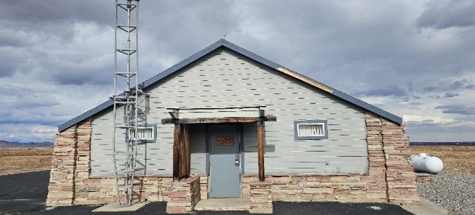
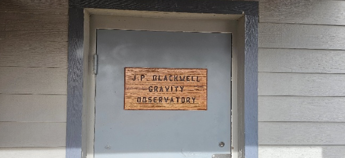
First, a special shout-out to my dear friend and former colleague, Juliana Blackwell, retired Director of the National Geodetic Survey. NOAA’s Table Mountain Gravity Observatory in Boulder, Colorado — long known for its absolute gravity work — has been officially renamed the J. P. Blackwell Gravity Observatory. This well-earned tribute honors her outstanding dedication and visionary leadership at NGS. Congratulations, Juliana!
J. P. Blackwell Gravity Observatory. (Photo: NGS)J. P. Blackwell Gravity Observatory. (Photo: NGS)J. P. Blackwell Gravity Observatory. (Photo: NGS)
NGS employees participated in the following sessions and meetings during GeoWeek 2026:
ASPRS NSRS Modernization Working Group Meeting
NSRS Modernization — The Latest Technical Updates
Preparing to Put the Modernized National Spatial Reference System into Practice
Roundtable — NSRS Modernization and Professional Societies
As President of the American Association for Geodetic Surveying (AAGS), I participated in the session titled “Roundtable – NSRS Modernization and Professional Societies.” Dana J Caccamise II, NGS regional geodetic advisor, opened our session by describing the NGS Modernization Engagement Plan and Progress. As I mentioned last month, Dana should get an award for the material he has prepared and for his work assisting agencies and professional organizations in preparing for the new NSRS. I highlighted Caccamise’s work in my October 2025 GPS World newsletter.
All the NGS sessions provided the latest information on activities associated with NGS’s NSRS Modernization. Here are the specific questions I had going into the session, along with the clear answers provided by NGS personnel during their presentations and the follow-up Q&A:
What NGS products and services will be available when federal agencies officially adopt the new NSRS?
When the modernized NSRS is officially adopted (following FGCS approval and the transition to it becoming “the NSRS”), NGS will make available a full suite of updated tools, data access points, and services built around the new reference frames (e.g., NATRF2022 and variants), the North American-Pacific Geopotential Datum of 2022 (NAPGD2022), the State Plane Coordinate System of 2022 (SPCS2022), and associated geopotential models like GEOID2022. Key products expected to be operational and official include:
NCAT
NGS Maps
Geodetic Station Page
CORS
Geodetic Mark Page
Passive Marks
OPUS–Static 5.2
OPUS-Share
What NGS products and services will NOT be available when federal agencies officially adopt the new NSRS?
Upon official adoption of the modernized NSRS — after FGCS approval and the shift to the new system becoming “the NSRS” — several current products and services will no longer be part of the official modernized NSRS or will be discontinued in their present form. Key items not included or no longer supported in the modernized NSRS release include:
OPUS Projects 5 will not be supported
OPUS-Rapid Static (OPUS-RS) will not be supported (modernized OPUS-Static 5.2 is expected to handle a broader range of observations)
OPUS 6.0 and OPUS 6.1 will not be available
What GNSS data will be included in the first iteration of the computation of Reference Epoch Coordinates (REC) for marks?
At Geo Week 2026, NGS stated that its plans include providing Reference Epoch Coordinates (RECs) for certain legacy GNSS projects. Specifically, this includes:
GPS projects that were originally processed and published under the NAD 83 (2011) realization, and
Other GNSS projects will be officially published by NGS through the end of 2025\
After the first iteration of Reference Epoch Coordinates, is NGS planning to perform future adjustments to determine REC and SEC of new marks? If so, what process will be used to establish RECs on new marks?
Yes, NGS plans include performing future adjustments to compute Reference Epoch Coordinates (REC) for new marks. However, at this time, no final decision has been made on how often this will be performed.
Has NGS changed how users need to submit data to incorporate leveling data into NAPDG2022?
Yes, NGS has introduced changes to better integrate leveling data (differential height differences) into the modernized NSRS for computing orthometric Reference Epoch Coordinates (RECs) in NAPGD2022 (epoch 2020.00).
As documented in Blueprint Document 3, when performing leveling projects, users will also be required to occupy a number of primary marks with GNSS.
OPUS 6.1 is built for future expansion to support other geodetic measurements (classical, leveling)-no timeframe was given for this.
Is NGS planning to officially adopt the new NSRS before users can submit data to NGS for technical review and publication in the NGS database?
Yes, that is what NGS is saying at this moment (February 2026). OPUS Project 5 will not be supported and OPUS 6.1 will not be operational when the new NSRS is officially adopted.NGS is working on the OPUS 6 application and is trying to “minimize any gap in service.”
Is NGS recommending using the OPUS-Share utility until users can submit data to NGS for technical review and publication in NGS database?
Yes, that is what NGS is recommending at this moment (February 2026).
OPUS-Projects 5 will not be included in the modernized NSRS. Instead, NGS will focus on both developing an improved software suite for OPUS, known as OPUS 6.0 and OPUS 6.1, and minimizing any gap in service in which the current OPUS-Projects functionality is not available for users to organize, process, adjust, and submit high-accuracy GPS surveys for use by NGS in expanding and improving the NSRS. As noted above, OPUS-Share will remain available as a means to submit data to NGS.
When will OPUS 6.1 be available for users to submit data to NGS for technical review and publication in NGS database? Is it weeks away, months away, or years away?
NGS has not announced an official completion or release date for OPUS 6.0 and OPUS 6.1. However, they have indicated that active development is underway on this enhanced OPUS tool suite. It’s not imminent— meaning not expected within several months—but it’s also not a distant, multi-year project.
NGS is working on the application and is trying to “minimize any gap in service.”
“OPUS-Projects 5 will not be included in the modernized NSRS. Instead, NGS will focus on both developing an improved software suite for OPUS, known as OPUS 6, and minimizing any gap in service in which the current OPUS-Projects functionality is not available for users to organize, process, adjust, and submit high-accuracy GPS surveys for use by NGS in expanding and improving the NSRS. As noted above, OPUS-Share will remain available as a means to submit data to NGS.”
What’s the cut-off date for users to submit projects via OPUS Project 5 so the data can be part of future computations of RECs?
Current OPUS-Projects 5 is going to be supported until adoption of the new NSRS, with a deadline announced at least 6 months in advance.
“Note: the current OPUS Projects 5 software will be supported until the modernized system is adopted, and a deadline for OPUS-Projects users to submit their surveys for publication will be announced with at least six months’ notice.”
In the session “NSRS Modernization – The Latest Technical Updates,” the National Geodetic Survey (NGS) presented slides detailing the status and upcoming tasks for the modernized National Spatial Reference System (NSRS). Key highlights from the presentation are summarized below.
106th Wyoming Engineering and Surveying (WES) Society Conference – February 5, 2026 – Brian Shaw
2026 GeoWeek – Modernized Tools – February 17, 2026 – Brian Shaw
2026 GeoWeek – Updates to OPUS for Accessing the Modernized NSRS – February 17, 2026 – Dan Gillins
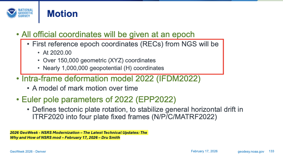
During Dru Smith’s presentation, he mentioned what will be included in the first iteration of the computation of Reference Epoch Coordinates (REC) for marks. The slide states that more than 150,000 geometric (XYZ) coordinates and 1 million geopotential coordinates (that is, orthometric heights) will get reference epoch coordinates (REC), epoch 2020.00. These will include data from NGS Integrated Database and from the OPUS Share database.
First Reference Epoch Coordinates (REC). (Presented at GeoWeek 2026)First Reference Epoch Coordinates (REC). (Presented at 106th WES Society Conference)
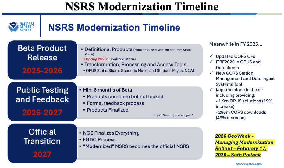
In the GeoWeek 2026 presentation by Seth Pollack (from NOAA’s National Geodetic Survey), a slide outlined the NSRS modernization timeline.
As detailed in the slide and consistent with NGS’s official rollout plan:
Beta products are currently being released incrementally on the beta site for public testing and feedback. This phased rollout began with initial beta releases in 2025 (following alpha in 2024) and continues through 2026, covering key components such as NAPGD2022, GEOID2022, SPCS2022, enhanced NCAT transformation tools, OPUS-Static updates, and forthcoming Data Delivery System features.
Each beta component, once released, undergoes public testing and stakeholder feedback, with overall testing continuing for at least 6 months after the final component is made available on the beta site.
Following sufficient testing—once all components appear stable and NGS has incorporated feedback—the Federal Geodetic Control Subcommittee (FGCS) will vote to recommend approval of the modernized NSRS. This vote is anticipated in late 2026 or early 2027.
Upon FGCS approval (and subsequent Federal Geographic Data Committee (FGDC) endorsement), NGS will probably publish a Federal Register Notice announcing the adoption. At that point, the modernized NSRS becomes the official National Spatial Reference System, replacing the legacy system (NAD 83 realizations, NAVD 88, etc.).
While earlier NGS documentation targeted adoption likely in mid-to-late 2026 (post-FGCS vote), recent updates from GeoWeek 2026 sessions and related reports indicate the full official adoption and transition may extend into the first part of 2027, accounting for final testing, FGCS/FGDC processes, Federal Register steps, and a smooth handover to avoid disruptions.
The current NSRS remains official throughout this period. Users are encouraged to test beta products now and provide feedback to help refine the system.
NSRS Modernization Timeline. (Presented at GeoWeek 2026)
Brian Shaw, NGS’s expert on GIS products and services, presented key updates on how users will access geodetic data in the modernized National Spatial Reference System (NSRS).
He emphasized the introduction of a revamped Data Delivery System (DDS), which includes:
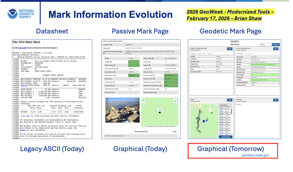
Geodetic Mark Pages — for passive marks. These replace the current ASCII-text datasheets with modernized, user-friendly pages featuring updated Reference Epoch Coordinates (RECs), integrated photos, graphics, maps, project details, and easier navigation.
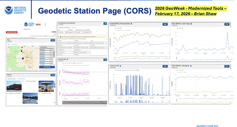
Geodetic Station Pages — for active stations like those in the NOAA CORS Network (NCN). These provide updated versions of existing CORS pages, including modernized coordinate functions (e.g., Coordinate Functions or time-dependent positioning info) aligned with the new reference frames (NATRF2022, etc.).
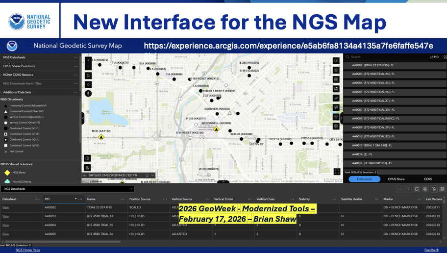
Additionally, Shaw highlighted a new interface for the NGS Map (the interactive web map application), serving as an enhanced landing page within the DDS. This updated “NGS Map” (replacing or evolving the current version at https://noaa.maps.arcgis.com/apps/webappviewer/index.html?id=190385f9aadb4cf1b0dd8759893032db ) will provide better access to geodetic control data, CORS stations, and other layers, improving visualization and querying for surveyors, GIS professionals, and the public.
These changes are part of the broader DDS rollout, currently pending beta release (as of February 2026), aimed at making data more accessible, visually rich, and compatible with the modernized NSRS components (e.g., NATRF2022, NAPGD2022, SPCS2022). The DDS landing page will consolidate access, moving away from legacy datasheet formats toward dynamic, web-based delivery.
Accessing Data from NGS. (Presented at GeoWeek 2026)Accessing Data from NGS. (Presented at GeoWeek 2026)Accessing Data from NGS. (Presented at GeoWeek 2026)
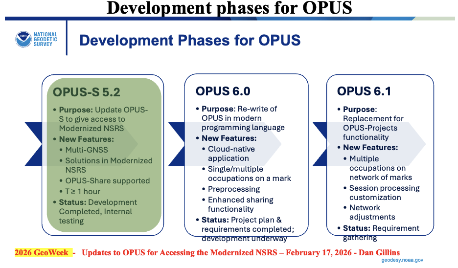
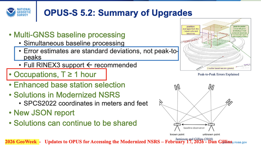
During Dan Gillins presentation he highlighted that NGS has three development phases for OPUS underway to support the Modernized NSRS:
OPUS-S 5.2:Multi-GNSS with similar functionality as current OPUS-S
Occupations – one hour or greater
Standard deviations estimate instead of peak-to-peak values
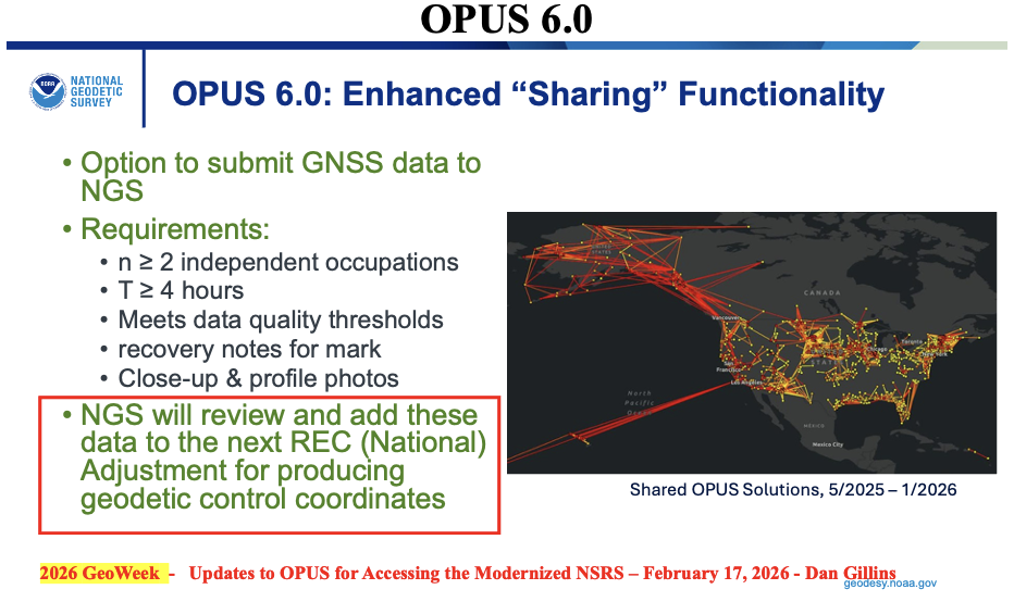
OPUS 6.0:Rewrite of code base in cloud-native application
single/multiple occupations on a single mark
enhanced sharing functionality
Occupation Time – minimum of 4 hours
NGS will review and add these data to the next reference epoch coordinate (REC) adjustment
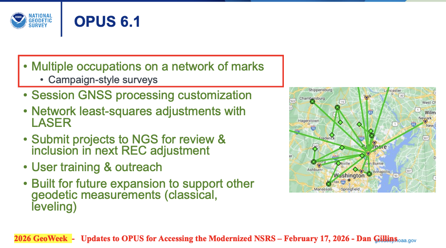
OPUS 6.1: Extension of OPUS 6.0 for multiple marks in a network
Replace OPUS-Projects functionality
Multiple occupations on a network of marks (campaign-style surveys)
Will allow multiple occupations on a single mark – uploads ~10 data files on a mark
Built for future expansion to support other geodetic measurements (classical, leveling)
I want to emphasize that, in my opinion, NGS is doing a fantastic job with the limited resources that they have. That said, I still have an issue with adopting the new NSRS without having a process for users to submit data to NGS for review, approval, and publication by NGS. This may not be an issue if NGS’s OPUS 6.1 is available soon after the new NSRS is adopted by the Federal Agencies.
My August 2025 GPS World Newsletter discussed the OPUS products under development and, as I mentioned at that time, in my opinion, may be a problem for some users. As I stated in my August newsletter, for the new NSRS to be successfully implemented by users, it is essential that all the necessary software tools are available to enable users to submit projects for review, approval and publication by NGS.
“The NGS News announcement provides a list of products that will be available and a list of products that will not be available when the new NSRS is adopted. Users need to understand what products will not be available after NGS officially adopts the new NSRS so they can determine what that means to their workflow process and client requirements. In my opinion, for the new NSRS to be successfully implemented by users, it is essential that all the necessary software tools are available to enable users to submit projects for review, approval, and publication by NGS. As many of you know, when I worked for NGS, I was the Project Manager of the North American Vertical Datum of 1988 (NAVD 88). That said, from my experience as the NAVD 88 Project Manager, having the appropriate tools available was important for users to implement NAVD 88. As a matter of fact, NGS accepted and processed vertical control data in both NGVD 29 and NAVD 88 for a period to assist users in the implementation of the new vertical reference datum.”
NGS does state that users will be able to submit data through OPUS and OPUS Share to obtain estimates of coordinates in the new NSRS. Unfortunately, using OPUS-Share results that are NOT official NSRS coordinates published by NGS could lead to confusing results and potential lawsuits since NGS does not stand behind the results and recommends NOT using OPUS-Share results for geodetic control.
“This is NGS’s statement on OPUS-Share: Additionally, the popular function of “sharing” your solution with others (colloquially called “OPUS-Share”) will be retained, but with appropriate caveats that the shared solution should not be used as geodetic control. These shared solutions will be available through the geodetic mark pages of the DDS.“
Why should users use OPUS-Share to establish geodetic control when NGS advises against relying on OPUS-Share for establishing geodetic control? OPUS-Share results are not officially submitted to NGS for review, approval, and publication on an NGS Datasheet. I don’t believe this approach will meet the needs of users who require their projects to be reviewed, approved, and published by NGS.
Finally, as someone deeply invested in the geodetic community—having retired from NGS and followed NGS developments closely for years—my overall opinion on the NSRS modernization rollout plan for the remaining products is cautiously positive, but with some genuine concerns that I believe NGS and stakeholders should address head-on to ensure a smoother transition.
The phased beta release approach (starting in 2025 and continuing through 2026) is smart and user focused. Releasing components incrementally on the beta site, allowing at least 6 months of public testing and feedback per major piece (and overall testing extending beyond the final release), shows NGS is prioritizing stability over speed. The emphasis on stakeholder input, FGCS approval (now looking like late 2026 or early 2027), and a multi-month transition to the official site align well with best practices for such a massive shift. It’s encouraging to see private industry partners (e.g., ESRI, Blue Marble) already engaging deeply and planning implementations—success will depend on industry buy-in.
That said, here are my main thoughts and concerns I’d share directly with NGS (perhaps via [email protected], user forums, or upcoming webinars/Q&A sessions):
Timeline uncertainty: Clearer, more frequent milestone updates (beyond the Track Our Progress page) would help manage expectations. For example, monthly or bimonthly “status dashboard” with remaining beta items and projected release windows would be invaluable.
OPUS and processing continuity: The shift away from OPUS-Projects 5 toward OPUS 6 and OPUS-Share is logical for a modern GNSS-centric system, but the lack of a firm end-of-support date for legacy OPUS tools (beyond “at least 6 months’ notice”) creates planning headaches for firms with ongoing projects. NGS should commit to a longer grace period—or ideally a defined parallel support window—for legacy OPUS tools (particularly OPUS-Projects 5) after the official adoption of the modernized NSRS.
Data access and usability in the new DDS: The revamped Geodetic Mark/Station Pages, updated NGS Map interface, and overall Data Delivery System sound promising (more visual, integrated RECs/SECs, photos, etc.), but surveyors rely heavily on reliable, scriptable access (e.g., for bulk queries or automation). If the new web-based system lacks robust APIs or export options comparable to current datasheets/legacy tools, it could hinder efficiency. Beta testers should push hard on this during the 6+ month window.
Transformation tools and legacy data handling: Enhanced web-based tools are key for bridging old-to-new (NAD 83/NAVD 88 to NATRF2022/NAPGD2022), but users need confidence that transformations minimize errors, especially in deformation-prone areas.
Communication and outreach: NGS has improved with webinars, the Presentations Library, and beta feedback channels, and more targeted outreach to state agencies, professional societies (NSPS, AAGS), and software vendors has helped. That said, many in the field still feel “in the dark” about practical impacts—case studies, training resources, and FAQs tailored to common workflows would go far.
In summary, the plan is thoughtful and deliberate, reflecting lessons from past delays. If NGS maintains transparency, incorporates feedback aggressively during beta, and ensures vendor readiness, the modernized NSRS will be a major win for accuracy, sustainability, and GNSS alignment.
I’d encourage anyone reading this (including NGS staff) to test the beta products actively, submit detailed feedback, and participate in forums/Q&As. The community input will make or break the success of this once-in-a-generation update.
Emesent has launched its GX1 all-in-one mobile scanning system at Geo Week 2026 in Denver.
The GX1 is an integrated, highly accurate all-in-one mobile scanning system combining simultaneous localization and mapping (SLAM), lidar, real-time kinematic (RTK) georeferencing, cameras and software. The product marks a breakthrough for the autonomous mapping technology company.
The GX1 supports a seamless workflow, from capture to validated deliverable. It not only brings Emesent’s proven SLAM technology to everyday surveying applications, but also eliminates the longstanding trade-off faced by survey firms and players in the architecture, engineering and construction (AEC) industry between mobile scanning speed and dependable survey-grade accuracy.
According to Emesent, the GX1 can reduce the time required to survey a site by up to 95%, reducing what once took weeks into a single day of scanning. Meanwhile, the independently validated global accuracy of 5-10 mm delivers the precision needed for use cases across topographic and road surveying, scan to building information models, construction progress tracking and more.
These capabilities are supported by integrated RTK georeferencing with real-time quality monitoring, four 20MP cameras for 360° panoramic imagery, and Emesent’s proven SLAM algorithm. This technology — which also powers the Emesent Hovermap product — was developed and validated in extreme real-world environments, including GPS-denied, underground locations to ensure repeatable accuracy and reliability both indoors and out. Accuracy validation reports are produced quickly and easily in the Aura processing software.
With four purpose-built deployment modes — backpack, survey pole, vehicle mount and supported handheld — and integrated batteries for cable-free management, the GX1 offers a high degree of versatility. In addition, surveyors can capture data using RTK in the field or using ground control points and checkpoints in post-processing. This flexible georeferencing minimizes the risk of having to return to a site for redo.
“With the introduction of the GX1, we’ve answered the call we’ve heard echoing throughout the surveying industry to end the tug-of-war between fast and accurate,” said Dr Stefan Hrabar, chief strategy officer and co-founder of Emesent. “By putting the power of SLAM into the hands of the everyday surveyor, the GX1 raises the bar for mobile scanning accuracy and keeps critical projects on track.”
The launch of the GX1 comes at a pivotal moment for survey firms and the AEC industry. They are grappling with a shortage of experienced surveyors, while also facing mounting pressure from clients demanding faster, cheaper and better results without compromising on quality. The GX1 has been designed to be simple enough for junior surveyors to train on and deploy in a matter of days. At the same time, it is powerful enough to meet — and, according to Emesent, exceed — the real-world needs of professionals in the field.
SparkFun Electronics has released the SparkPNT TX2, a quad-band GNSS rover that combines an IP67-rated aluminum enclosure with support for Galileo’s High Accuracy Service (HAS) and standard RTK correction workflows.
The receiver is built around the Quectel LG290P quad-band GNSS engine and supports multi-constellation tracking. Galileo HAS support provides sub-20 cm accuracy globally without subscription-based correction services, while RTK workflows via NTRIP or u-blox PointPerfect can achieve centimeter-level positioning.
Battery life is rated at 50-plus hours, positioning the TX2 for multi-day field campaigns without recharging. The unit connects to iOS and Android devices via Bluetooth and Wi-Fi, with compatibility reported for common GIS and data-collection applications.
A notable design choice is the open-source firmware, which gives users visibility into how positioning data is processed and allows for customization and third-party integration. SparkFun has positioned this as an alternative to closed GNSS ecosystems where firmware and processing pipelines are not user-accessible.