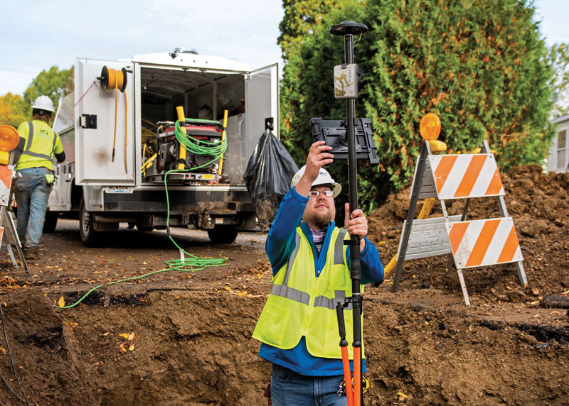
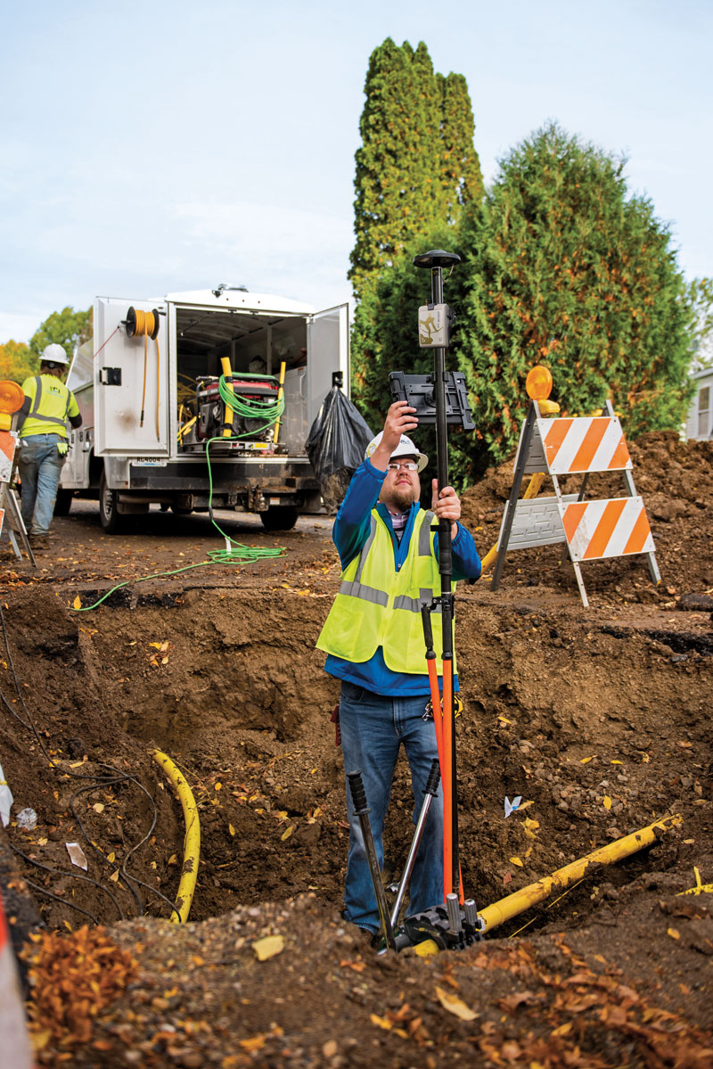
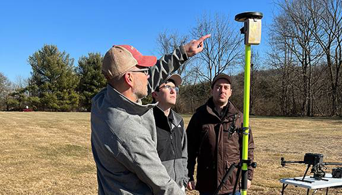
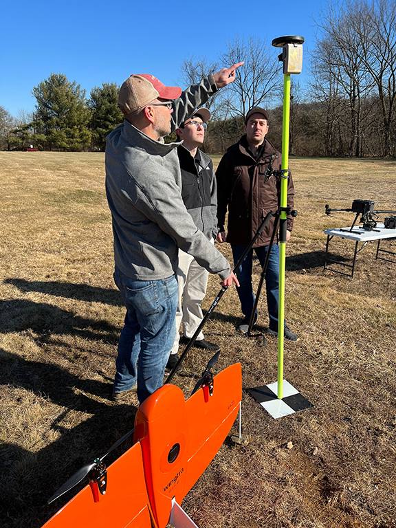
The danger of hitting a buried water or gas pipe when digging for a construction project persists despite many efforts to reduce it, such as “call before you dig” phone numbers. For example, in Minnesota there were 4,000 such hits in 2019. That is one reason why it is very important to map “as built” underground utilities accurately. This must be done quickly and efficiently, before trenches are filled and without slowing progress of the project.
Traditionally, crews have mapped the underground pipes and cables on paper. In turn, when a construction project needs to know the location of underground utilities before digging, it typically relies on someone who consults those paper maps, uses an electromagnetic utility locating tool, and marks the ground with spray paint. The construction crew then must correctly interpret those marks on the ground. In 2019, Minnesota-based utility consultancy Ellingson Companies was asked to develop a new and more efficient process.
Capturing Data in Real Time
By leveraging solutions from Esri and from Canadian hardware and software manufacturer Eos Positioning Systems, Ellingson Companies GIS Manager Damon Nelton developed a solution that allows his team to capture new pipe construction in real time. By streamlining documentation workflows, the new process improved field productivity and allowed Ellingson Companies to produce digital as-builts that meet the needs of its gas utility clients and improve the safety of future construction projects.
While construction crews have been putting pipe in the ground for generations, today they are expected to produce a digital record of their work in real time — for the sake of safety and efficiency.
Using Esri’s Utility Pipeline Data Model, Nelton created a system that enables crews to map their as-built pipe projects while also tracking components. The system improves data integrity — in other words, reduces human error — by relying on scannable 16-digit alphanumeric bar codes developed by the American Society for Testing and Materials that provide seven attributes for each conduit, including thickness, diameter, lot number and manufacturer date. To collect and store these data, Nelton set up an ArcGIS Enterprise geodatabase.
Gas meters, which also need to be mapped, are often in locations that are hard to map directly with a GNSS receiver because line-of-sight to the satellites is obstructed by trees, roof eves, or adjacent buildings. Therefore, they must be shot with an offset. For these situations, Nelton used Eos Positioning Systems’ laser mapping solution, which enables surveyors to use lasers attached to their range poles to feed data directly into their GIS.
No More Battleship
Using Eos Positioning System’s Arrow Gold receiver and the MNCoors RTK network, Nelton said, his team was able to average an accuracy of 0.25 throughout a project in the city of Owatonna, Minnesota, as confirmed by spot checks with other survey equipment and with the city’s survey team.
“Not every shot was easy, and some took multiple attempts and tricks of the trade to get them,” Nelton pointed out.
On projects in the middle of mountains, where real-time kinematic (RTK) networks do not exist, the company has used the Atlas Service, averaging accuracies of 12 in.
“Given the circumstances of these projects,” Nelton said, “we still consider that to be great.”
Using the new system, foremen use a survey in ArcGIS Survey123 to input their inspection notes and other information, feeding it all from the field to the office and into layers shared between divisions. This way, the data are available in real time, not at the end of the project.
For customers who still want a piece of paper to file in a physical folder in a filing cabinet, Nelton creates a Microsoft Word document template in their format, populates it using dynamic text with syntax in ArcGIS Pro, inserts a map, then saves the Word document as a PDF.
“At the end of the project, we got almost 17,000 digits with no human entry other than pressing the button on the barcode scanner, which means zero data errors,” said Nelton.
No pieces of paper with critical data on the underground utilities languish in a glove compartment or are eaten by a surveyor’s dog, and all the data is available in real time.
Additionally, the combination of the barcode scanning workflow and the high accuracy GNSS receiver enables Nelton’s team to locate gas asset pieces that need to be replaced — for example, due to a recall by the manufacturer — “without playing battleship,” he said.
GeoCue has released the TrueView 535 imaging system for UAVs, and the TrueView 720, its fourth-generation Riegl integration. It also launched its LP360 software add-on called 3D Accuracy and the Accuracy Star hardware.
TrueView 535 is built on TrueView 515’s technology and consists of updated lidar sensors, adding a third return, increasing mapping abilities below canopy. An additional third nadir camera offers another point-of-view and improves photogrammetry quality. It also includes a longer, usable lidar range to increase flexibility.
TrueView 535. (Image: GeoCue)
TrueView 720 is a fourth-generation Riegl VUX-120 with three laser beam orientations. It provides high point-density corridor mapping. Using the Riegl VUX-120 with three laser beam orientations (nadir, +10-degrees forward and –10-degrees backward) and three oblique/nadir cameras enables data collection from more surfaces in one flight path.
Trueview 720. (Image: GeoCue)
One application of TrueView 720 is scanning power lines. Users can capture the poles vertically, front and back. The extreme range of this system means it can be integrated with UAVs, airplanes or helicopters.
In addition to the two sensor payloads, GeoCue has launched its LP360 software add-on for processing and visualization — the 3D Accuracy and the Accuracy Star hardware.
Accuracy Star. (Image: GeoCue)
“When used together, Accuracy Star and the 3D Accuracy add-on provide automated horizontal and vertical checks,” said Darrick Wagg, vice president of customer success for GeoCue. “You can automatically find a 3D target on a drone dataset. The software will calculate the correction for any 3D target and provide a seamless workflow to apply the correction on the point cloud.”
These products are suitable for geospatial professionals.
Trimble has released Trimble 4D Control (T4D) version 6.4 software and an add-on monitoring module for automated and semi-automated rail monitoring. The T4D Rail module enables simple data collection and reduces office work required to automate movement detection for rail monitoring projects.
The T4D software offers four main elements for automated monitoring: sensor management and data integration for GNSS, total station, geotechnical, vibration and environmental sensors; geodetic processing and adjustments for accurate results; analysis and visualization through several tools that provide real-time updates to support in-depth analysis and data presentation; and alarming and reporting.
The T4D Rail module enables integration of rail as-builts collected with the Trimble GEDO system or with a track measuring bar paired with the Trimble Access Gauge Survey app. It can also automate calculations for track geometry parameters, generate analysis charts, and trigger alarms.
The T4D software is offered in five editions to fit various project requirements. The editions include T4D Access, T4D Field, T4D Intermediate, T4D Geotechnical and T4D Advanced. T4D Access and T4D Advanced are the two editions that support the add-on Rail Module.
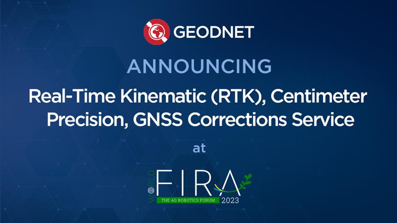
GEODNET has released a real-time kinematic (RTK), centimeter-precision, GNSS corrections service designed for OEMs and system integrators of agricultural robotics. GEODNET is compatible with several GNSS receivers from major brands, on-vehicle automated steering, spraying kits, and most UAVs and robots.
The GEODNET corrections service has more than 1,700 total full-constellation reference stations worldwide and supports GPS, Galileo, GLONASS and BDS signals. It also has the RTCM 3.2 data format for maximum rover/receiver compatibility and NTRIP sign-on and access.
Additional local reference stations can be added.
Free GEODNET correction service trials are available now for qualified OEMs and system integrators in most agricultural regions globally. Interested parties can apply for a trial stream here.
Atmos has integrated the Sony a7R mark III and IV camera into its vertical take-off and landing (VTOL) fixed-wing UAV, the Marlyn Cobalt. This will increase coverage and accuracy achieved in a single flight for surveyors.
Both cameras have an ISO of 32,000, which is expandable to 102,400, and camera sensors with high megapixel count — 42,4 MP for the a7R III and 61 MP for the a7R IV. When combined with Zeiss’ 35 mm and 21 mm lenses, it enables UAV surveyors to achieve ground sample distance levels below one 1 cm.
The integration of the two cameras enables Marlyn Cobalt users to map an area of 210 hectares with centimeter-level accuracy in a single flight.
UAV Navigation-Grupo Oesía has released the GHU-100 ground control hub unit that helps platform manufacturers connect multiple ground devices to form a single network segment.
The GHU-100 enables multi-UAV and multi-ground control system (GCS) operation and is also designed to fulfill all requirements of maritime operations. This includes control of NMEA inputs, real-time kinematic corrections, and more. The ground control station hub unit also increases UAV flight safety, as it is independent from the computer OS and its potential PC crashes.
The GHU-100 is designed to increase a system’s robustness while maintaining a high flexibility with its extensive input/output capabilities, which makes it easy to integrate into complex and advanced GCS architectures. It also implements critical functionalities on a self-developed real-time operating system to ensure secure missions in all environments.
A roundup of recent products in the GNSS and inertial positioning industry from the January 2023 issue of GPS World magazine.
SURVEYING & MAPPING
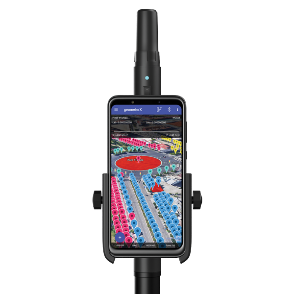
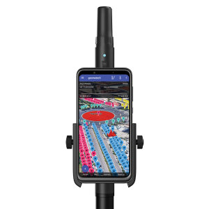
Image: Geometer International
Dual-Frequency Receiver
Receives all GNSS constellations plus SBAS
The Walker RTK is a dual-frequency GNSS receiver (L1, L2) for high-precision coordinate surveying in real-time kinematic (RTK) mode. It comes with a helical antenna, a bracket for attaching a smartphone, and the Geometer SCOUT mobile app. A classic geodesic antenna can be connected through the SMA connector. The Walker RTK has a rugged aluminum alloy casing with a shock-resistant coating, yet weighs only 250 grams. GNSS signals processed by the Walker RTK GNSS receiver include GPS (L1C/A, L2C), GLONASS (L1OF, L2OF), Galileo (E1B/C, E5b), BeiDou (B1I, B2I), QZSS (L1C/A, L1S, L2C) and SBAS (L1C/A). A built-in rechargeable battery provides 24 hours of continuous operation without recharging.
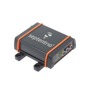
The AsteRx SB3 ProBase creates high-quality measurements for real-time kinematic (RTK) and differential corrections. The IP68-housed GNSS base station receiver features the latest quad-constellation GNSS technology and complements the SB3 receiver family: the AsteRx SB3 Pro rover receiver, the AsteRx SB3 Pro+ rover and base receiver, and the AsteRx SB3 CLAS for the Japanese market. The SB3 ProBase is easy to configure, the company says. It comes with Septentrio’s GNSS+ technologies, including anti-jam and anti-spoofing technology (AIM+) for robustness and reliability. AsteRx SB3 products are pin-to-pin compatible with the AsteRx SB ProDirect receiver and the recently released AsteRx SBi3 GNSS/INS system.
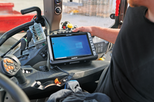
The Algiz 10XR is a rugged 10-inch Windows tablet that combines durability with a GNSS receiver and 5G communications. It was developed for challenging environments in logistics, mining, public transport, public safety, waste management or geographic information systems (GIS). The 10xR is customizable and has a dedicated multiband GNSS u-blox NEO-M8U receiver for accurate positioning as well as untethered dead-reckoning technology. The high-resolution, sunlight-readable 10-inch touchscreen has super-hardened glass and rain-and-glove mode. The tablet also has 4G/LTE high-speed data, Wi-Fi and Bluetooth.
The VZ-600i terrestrial laser scanner has a 3D position accuracy of 3 mm and less than 30 seconds of scan time for high-resolution scans with 6 mm point spacing at 10 m. This enables more than 60 scan positions per hour with real-time registration. Weighing less than 6 kg (13 pounds), the VZ-600i has a 2.2-MHZ pulse repetition rate, three internal cameras and an integrated GNSS receiver. It also includes key features to speed up workflows in indoor and outdoor applications such as architecture, engineering, construction, building information modeling, as-built surveying, forensic and crash scene investigation, archaeology and cultural heritage documentation and forestry.
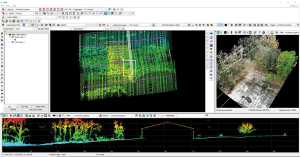
The LP360 Drone software system provides a geospatial-data workflow for UAV lidar and photogrammetry data processing. It provides powerful point cloud visualizations with multiple, synchronized windows. It can transform lidar and imagery data into survey-grade deliverables including visualization, quality checks, classification, analysis and 3D editing. For users of larger datasets, LP360 Geospatial can process captured lidar data or images from any aircraft or mobile sensor and analyze and extract values.
Free library offers data on healthcare, business, traffic
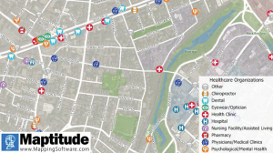
The extensive Maptitude library of free mapping databases has been updated for 2022 and is available for download, supporting insightful business development analysis. The data is available free to users of the latest version of the Maptitude mapping software. The data are also available as shapefile, KML, KMZ or GeoJSON for a fee. Maptitude includes business-critical data such as demographics, boundaries, streets, and the most ZIP Code/postal boundaries. Also available is a catalog of free premium datasets that can be used in other GIS applications, on the web, or in corporate databases.
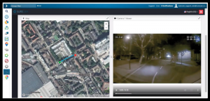
Indoor and outdoor tracking of low-power, small IoT devices
Traxmate is integrating Nestwave GNSS location technology into its asset-tracking platform for seamless indoor and outdoor positioning, tracking and routing of small, low-power and battery-powered devices for the internet of things (IoT). Nestwave’s NestCore IP and NestCloud cloud services enable power-efficient geolocation solutions, while Traxmate (pictured) is a comprehensive data-processing hub that simplifies setup of tracking environments and provides real-time visualization of device location. The resulting geolocation solution is suitable for applications ranging from carrier tracking to tracking individual parcels and packets. Traxmate is simple to use and set up, requires no coding, and provides an out-of-the-box feature set that includes dashboards, alerts and processing rules for taking actions on incoming data. Nestwave’s trackers include ThinTrack, an ultra-low-profile, compact GPS tracking solution that integrates an LTE-M/NB-IoT modem, antenna, battery and SIM into a device that measures 82 mm x 35 mm x3 mm and weighs 15 g.
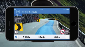
Provides guidance even without an internet connection
The Sygic GPS Navigation app uses a smartphone’s camera and augmented reality to display navigation instructions over the view ahead on the windshield. The head-up display is especially useful at night, enabling recognition of critical speed limit, road work or traffic restriction signs. Cockpit is a powerful tool that shows the real-time performance of the car, measuring the G force and actual speed to help users drive economically. The Dashcam feature records the road ahead and automatically saves the video in case of an accident. An Electric Vehicle Mode locates nearby charging stations.
Enhanced data-based rule implementation for fleets
An enhanced SureCam video telematics integration provides fleet managers with access to new capabilities to keep drivers safe and maximize fleet efficiency. The solution features a method for capturing video footage from SureCam cameras using Geotab’s powerful telematics device and rule-based system. The result is a seamless display of video within the MyGeotab platform. The enhanced SureCam fleet video solution leverages Geotab’s numerous data-based rules, such as improper seat belt usage and speeding. It uses G-force triggered alerts that detect unsafe driving behaviors and automatically captures video footage that can be reviewed later on the MyGeotab platform and alert managers to incidents when necessary. Camera configuration and customized triggers are managed directly within MyGeotab.
Driver 2.0 is a Level 4 production-ready autonomous driving solution that can operate in complex and challenging traffic environments. Demonstrations with Driver 2.0 showed an autonomous vehicle could maneuver around double-parked cars, e-scooters and pedestrians, negotiate oncoming vehicles to calculate the right timing and trajectory to pass busy intersections, and make multiple lane changes and unprotected left turns. In the case of long tail scenarios, the system will alert the remote monitoring center to intervene or take other safety measures. Driver 2.0 includes five solid-state lidar units, eight cameras and other sensors, and a computing platform integrated with a proprietary inference engine. The perception algorithm with sensor fusion can achieve precise object detection up to nearly 220 yards. The planning and control algorithm based on game theory can choose optimal routes and make decisions based on real-time situations when negotiating with oncoming vehicles and other road agents.
Provide improved signal gain for automotive antennas
Two new compounds could improve signal-gain performance compared to ceramics in second-generation automotive GNSS antennas. The new compounds — LNP Thermocomp ZKC0CXXD and LNP Thermocomp ZKC0DXXD — help enable the design and molding of antenna substrates with more complex pattern markings that add effective surface area, a critical factor in enhancing signal capture. They also provide flexibility to produce smaller parts with the same performance as ceramic, or equal-size parts with better performance. The LNP Thermocomp compounds feature electroplating capability, good thermal resistance for reliability, and the design freedom and production efficiency of thermoplastics. Both are well-suited for shark-fin-style and new conformal antenna designs.
SABIC, sabic.com
AUTONOMOUS
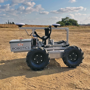
Image: Civ Robotics
Robotic Surveyor
Precisely marks thousands of coordinates per day
The CivDot unmanned ground vehicle (UGV) is designed for civil engineering and infrastructure projects such as solar farms, roadways, data centers, power plants and more. The autonomous surveying robot is designed to increase efficiency, productivity and safety on the job. Augmenting the surveyor’s work, CivDot marks thousands of coordinates per day precisely and efficiently, while delivering layouts faster than traditional methods. Civ Robotics uses Trimble’s high-precision GNSS positioning technology and surveying software.
The compact DJI Mavic 3E and 3T drones have been designed for an array of commercial missions. Flight time is 45 minutes. Both models have a real-time kinematic (RTK) module that enables surveying professionals to achieve centimeter-level accuracy with support for network RTK, custom network RTK services, and the D-RTK 2 Mobile Station. The D-RTK 2 Mobile Station is DJI’s upgraded high-precision GNSS receiver that supports all major GNSS, providing real-time differential corrections. The DJI Mavic 3E enables efficient mapping and surveying missions without the need for ground control points. The DJI Mavic 3T is engineered for aerial operations in firefighting, search and rescue, inspections and night missions.
AlphaRTK has signed agreements with Rutgers University, West Chester University and Warren County Community College to provide free access to its GNSS correction network for students and faculty.
The AlphaRTK network — an affordable RTK subscription network that supports four constellations — launched in 2021 and is available for use in New Jersey as well as both the New York City and Philadelphia metropolitan areas.
All institutions perform geospatial research and instruction. Having access to the AlphaRTK network is a powerful resource and will enhance the performance of modern geospatial data collection, the company said.
Warren County Community College specializes in precision agriculture using drones. The AlphaRTK network will provide its fleet with centimeter-level accuracy, advancing analytical capabilities. Rutgers University plans to advance turf farm research, and West Chester University aims to use the network for a geophysics course, among more geospatial research.
AlphaRTK records raw RINEX data that can be used for post-processing workflows, such as with post-processed kinematic drones. Additionally, in southern New Jersey where wireless coverage is weak, Alpha RTK has added ultra-high frequency radio transmitters to broadcast real-time data wirelessly.
The Choctaw Nation of Oklahoma (CNO) Beyond Program and uAvionix have received approval from the Federal Aviation Administration (FAA) for beyond-visual-line-of-sight (BVLOS) operations. The approval signifies uAvionix and the CNO have demonstrated to the FAA that the aircraft procedures, detect-and-avoid systems and control network meet the safety requirement for operation in the national airspace.
This is the second BVLOS waiver granted by the FAA for the combinations of uAvionix SkyLine software and SkyLink hardware, allowing UAV pilots operating at the CNO range to use only an electronic observer.
The CNO will be using uAvionix SkyLine command-and-control (C2) management platform and pingStation3 dual-mode ADS-B receivers at the Emerging Aviation Technology Center UAS Test Range. The SkyLine C2 management platform is integrated with the DeTect Harrier radar for surveillance, and is used to control several CNO and uAvionix owned electric vehicle takeoff and landing aircraft through muLTElink and SkyLink series C2 radios.
“Having this capability available at CNO enables our customers to conduct testing and demonstration in Oklahoma and will further serve as guidance for future applications leveraging this concept of operations,” said uAvionix President Christian Ramsey.
Transport Canada has approved Ontario Power Generation (OPG) to operate Percepto’s drone-in-a-box solution beyond visual line of sight (BVLOS) at McConnell Lake Control Dam without a visual observer on site. A BVLOS Special Flight Operations Certificate was issued for the Percepto Air Max autonomous drone-in-a-box for the remote inspection.
The approval enables remote inspection of the dam as a part of a pilot project, which started in January. Since Canadian power utilities are seeking to ensure their power grid and stations are resilient, the OPG facility will gain actionable insights from the remote inspection.
Percepto’s automated drone-in-a-box has been deployed by other electric utilities to monitor the durability of power grid infrastructure and quickly detect problems, enabling faster response times and restoring power quicker after storms and natural disasters.
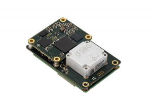
SBG Systems has released Quanta Plus, a GNSS-aided inertial navigation system (INS). Quanta Plus is a small, lightweight product, which can be easily integrated into survey systems with lidar or other third-party sensors.
The device combines a micro-electromechanical (MEMS) inertial measurement unit (IMU) with a resilient GNSS receiver to get reliable position and attitude, providing real-time kinematic (RTK) fixes.
Quanta Plus includes motion profiles, which enable users to optimize the sensor parameters to suit different use cases. The built-in precise time protocol server ensures sub-microsecond synchronization with external devices such as lidar. The device also has a built-in datalogger, Ethernet interface for easy integration, and a web configuration interface for simple setup and control.
The INS can be integrated with Qinertia, SBG System’s post-processing software. Qinertia improves the performance of acquired data during a mission using reliable RTK corrections from a wide range of continuously operating reference station networks, or by importing base-station data during the process.
Quanta Plus also improves the accuracy of the position and attitude using forward and backward processing and by integrating a tight coupling between GNSS and IMU data.
Quanta Plus is suitable for survey professionals or a navigation-dependent company seeking a robust navigation device. Specific solutions are available for integrators and OEMs who want to use Qinertia as a component in their application-specific data-processing solutions.
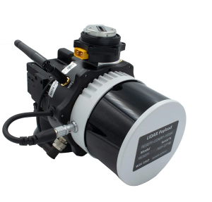
Inertial Labs has released a remote sensing payload instrument. The Resepi Hesai XT32 laser is designed for accurate remote-sensing applications. The Resepi laser can be used with commercially available lidar scanners, including Velodyne, Quanergy, Ouster, RIEGL, LIVOX and Hesai, as well as with UAVs.
Resepi is completely modular, so users have full control for customization. The remote sensing device uses a GPS-aided inertial navigation system with NovAtel RTK/PPK single- or dual-antenna GNSS receiver, integrated with a Linux-based processing platform. It also comes with a 2 TB USB memory drive and has an embedded Wi-Fi cellular modem.
Resepi has 3-5 cm point-cloud accuracy and can reach heights of more than 200 m above ground level. It is compatible with most UAV models; however, it is typically used with DJI M300, DJI M210 or DJI M600 models.
The device is suitable for scanning and mapping, precision agriculture with lidar, simultaneous localization and mapping (SLAM) algorithm development, utility inspection and construction site monitoring. Resepi-supported software includes Hexagon NovAtel, PCPainter and PCMaster.