The average age of surveyors in the United States is nearly that of retirement. Can new technology attract a new generation to the profession?
“We do not fully understand the trend in the United States,” said Simon Peng, ComNav Technology, “but in China we find that modern survey technology — such as UAV/lidar mapping and total stations — make field work simple. New trends such as computer imaging, point clouds and building information models (BIM) attract young surveying engineers.”
Using the equipment in the field is becoming increasingly easier, said Bernhard Richter, Leica Geosystems. “Our goal is that operating the field equipment should not be more difficult than playing with your smartphone. That means that you don’t need the super expert in the field so much anymore.” However, he argued, “someone who studied surveying should now be more the data manager, have the expertise to put the data in geospatial relation, and know in which reference frame he is operating.”
For example, that person needs to know about orthometric and ellipsoidal heights, especially for engineering projects between countries that might have different height codes. “Anybody who has an interest to geolocate an object can capture the data and upload it to the cloud environment,” Richter said. “Then there are the data managers. Certainly, they need to know the physical limits of surveying technology, and they need to manage the complexity of modeling Earth. They need to become data managers to really put data to work.”
“The anticipated number of new professionals is not necessarily replacing all the surveyors who are expected to retire over the next 10 years,” said Boris Skopljak, Trimble. To tackle this challenge Trimble is using a two-pronged approach: attracting younger workers by raising awareness of surveying as a future career and modernization of the profession. For the first prong, Skopljak cited “phenomenal programs out there, such as Get Kids into Survey.” He pointed out that many Trimble employees are part of those education programs, “promoting inclusion of not just a younger generation, but also of women and minority groups that are heavily underrepresented in our industry today.”
For the second prong, “Digital data capture workflows present opportunities. A very common interview question we ask these days is ‘Do you play video games?’ Generally, those young professionals who are gamers thrive in the 3D environment. The technology aligns well with the interests of younger folks.”
Additionally, a growing number of educational institutions are evolving their curriculums to meet these needs, said Skopljak. Trimble is establishing Trimble Technology Labs in selected academic institutions around the world that are helping students access the latest technology and the best modern engineering practices. Boosting productivity also helps compensate for the declining number of surveyors, because it reduces the number of people needed to get the job done. “As the technology becomes easier to digest and operate and more focused on the workflows, it also becomes easier for companies to standardize it and attract talent,” Skopljak said.
One of the biggest threats to the survey profession, according to Huff, is that it “let bits and pieces of traditional surveys fall off to the wayside.” Geographic information systems (GIS) use the same positioning technology, he pointed out. “Fifty years ago, that was more of a function of the surveyor than it was necessarily the GIS profession. In many ways, while the surveyor is aging — the licensed cadastral surveyors certainly are aging — there is a new generation of folks coming through who are leveraging the new technology, such as drones and mobile mapping systems.”
This new generation, Huff argued, will achieve the same accuracies as the previous one partly because it’s getting easier to do so. “We definitely have more of a generation of digital users that can leverage the technology to do things where even my mentors performed many calculations by hand, on the fly, from plain tables in their logbooks with sine, cosine and tangent in them. Now, I think that technology and 3D immersive technology, which hinges on GPS location, attracts a younger crowd to certain facets of the profession.”
François Freulon, Septentrio, agreed that new technologies now available “can be easily adopted by new generations in the profession,” yet added that “quality surveying requires a good formation and experience in the field.” Therefore, he argued, “surveying education systems will need to adapt their programs and incorporate newer techniques such as new positioning modes and corrections.
Surely RTK remains as the main accuracy technique, but this could change quickly in the coming years as correction services bring better performance and regional coverage.”
Advances in GNSS technology constantly expand the range of projects that benefit from them.
ComNav Technology
A telecom company adopted its CORS station to build China’s national CORS service for public companies. It is increasingly used for field robotics, including the development of self-driving cars.
Leica Geosystems
Bernhard Richter, vice president of Geomatics, Leica Geosystems AG, pointed to one of the biggest infrastructure projects in Europe, which aims to connect London to Birmingham, Manchester and Leeds with a high-speed railway system, avoiding the need to fly between those cities. This will have great environmental benefits because high-speed trains are much more efficient than planes.
However, high-speed rail requires tremendous precision. “First comes the prep work, moving dirt,” said Richter. “Then you must install the railroad ties with tenths of a millimeter precision relative to each other to avoid side accelerations. For a surveyor, it really has everything in one project. You need to constantly work with civil engineers. You then try to build as much as possible with machine-control-guided systems to make the leveling as automated as possible.” The project will include building bridges over whole valleys and monitoring them, particularly during the construction phase, to ensure that they are not moving.
“Even the factory they are building is huge, so just to build the factory you need a lot of surveying,” Richter said. The project is generating 25,000 jobs at 300 construction sites, all of which must be managed on very tight schedules. In this context, the quality of the survey gear is critical. “On a construction site, the surveyor should be an invisible person,” Richter said. “When they come with the big machines and want to get stuff done, they don’t want a surveyor on the site. So, he has to work off hours, then remain on alert and trust that what comes out of an instrument is correct.” Leica Geosystems is one of the main suppliers for this project. “They chose us because of our focus on reliability, trust and quality.”
Trimble
Software is increasingly driving sales, pointed out Boris Skopljak, vice president, Surveying & Mapping Strategy and Product Marketing at Trimble Inc. As an example, he cited Trimble’s SX12 scanning total station, which uses Trimble Access software to leverage scanning, imaging and traditional total station capabilities in the field. “We have provided more inspection tools to enable people to decide whether something is meeting the tolerance.” The Trimble Connect cloud-based collaboration platform, coupled with the continuous field and office connectivity, has driven productivity increases and moved customers toward choosing the company’s solutions, he said.
As an example of Trimble solutions, Skopljak cited City Rail Link, New Zealand’s first underground rail network and the largest transportation infrastructure project ever undertaken there. “The Trimble R10 was integral to acquiring static observations above the work site, while the Trimble S9, DiNi and Trimble Business Center network adjustment were game changers for the survey control network,” he said. To expedite mine tunneling the surveyors used the SX12’s combined total station and scanning functionality with Trimble Access field software infield inspection tools. “Fewer customers are choosing solutions on a spec. It’s not about how many satellites you can track, for how many days, or how many points you can scan. They are choosing solutions based on the ecosystem and productivity.”
The new device will ship in the fourth quarter of this year and is available for pre-order
Juniper Systems is entering the 10-inch rugged tablet market with the launch of its Mesa Pro rugged tablet. The Mesa Pro features 11th Generation Intel Core processors, a Windows 11 operating system, device customization options, a large sunlight-readable display and “Juniper Rugged” company design.
“We are excited to be entering the 10-inch rugged tablet segment for the first time,” said Darren Hellstern, the Mesa Pro product manager at Juniper Systems. “Mesa Pro offers powerful processing, a rugged design meant for any environment, and is a versatile workstation that can be used in the office or the field.”
Standard Mesa Pro units come equipped with an 11th Gen Intel Core i5 processor and 16 GB of LPDDR4x RAM. Core i7 and Celeron versions of the device are also available.
Each Mesa Pro configuration offers powerful performance and allows users to select a level of computing performance that best fits their needs while having options that meet their budgets.
“It was important for us to offer performance tiers,” said Hellstern. “This is the first time we have offered various performance levels in one of our devices. The needs that our customers and users have varies greatly. From running CAD programs, viewing construction plans, mapping and mounted-vehicle solutions, we feel that we have an offering with Mesa Pro that fits the processing need of the user. We are also available to help users determine what level of performance they need.”
Mesa Pro joins the current Mesa family of 7-inch devices and helps Juniper Systems achieve its mission of providing powerful rugged computing and data-collection devices to mobile field workers everywhere. The Mesa 3 runs on either Windows or Android operating systems. The Mesa family started in 2010 with the launch of the Mesa Rugged Notepad.
“Mesa devices have served our customers for over a decade,” said Hellstern. “We are proud to add Mesa Pro to that list of incredible devices and offer more options to our customers and users around the world.”
Juniper Systems is now accepting pre-orders for the Mesa Pro.
“Nothing can remain immense if it can be measured,” Hannah Arendt wrote in 1958 in The Human Condition. This could be the guiding inspiration for any geodesist or surveyor throughout history. In about 240 B.C., Eratosthenes became the father of geodesy by ingeniously measuring Earth’s circumference using the Sun, a well, a vertical column, the distance a camel caravan traveled from Syene to Alexandria and some basic mathematics. His estimate of 46,000 kilometers was 16% too large but remarkably close considering that he lacked any modern measuring tool. (For a great account of this epic feat, see John Noble Wilford’s The Mapmakers.)
Geodesy, a branch of applied mathematics, is concerned with accurately measuring and understanding three of Earth’s fundamental properties: its geometric shape, its orientation in space, and its gravity field. Earth’s true shape varies from the mathematically smooth surface of an ellipsoid due to local differences in its density that cause variations in the strength of the gravitational pull, in turn causing regions to dip below or bulge above a reference ellipsoid.
This undulating shape is the geoid, which geodesists have defined as the three-dimensional surface along which the pull of gravity is a specific constant. It serves as the zero-level surface for height measurements globally, and all GNSS are pegged to it. It is a hypothetical surface that essentially represents an extension of the idealized mean sea level over (actually, mostly under) Earth’s land surface. Unlike the surface of the oceans, however, it is unaffected by wind, waves, the Moon, or forces other than Earth’s gravity.
Surveyors are content with measuring much smaller portions of Earth’s surface, from single lots to national boundaries. Unlike Eratosthenes, they work with the latest fruit of modern science and technology — including GNSS receivers, robotic total stations, inertial measurement units, lidar, other sensors and unmanned aerial vehicles — and can measure distances with millimeter precision.
When I started in this business a little more than 20 years ago, we used to group GPS receivers by accuracy into three buckets: consumer grade, resource/mapping grade and survey grade. As accuracy has increased for all GNSS receivers, the boundaries between those categories, especially between mapping and surveying, have blurred. Additionally, we now have way more GNSS satellites — in some parts of the world, as many as 70 are in view at one time — and a panoply of public and private, ground-based and satellite-based corrections services.
So, surveyors have a growing set of tools, and they are constantly getting more accurate and more user-friendly.
Now, let me throw another number in the mix: 66. That is the average age of surveyors in the United States. In the short run, employment for surveyors hinges in part on the vagaries of the economy. In the long run, however, population growth and climate change will force large investments in infrastructure. On most construction sites, the first to arrive and the last to leave are the surveyors. We know what their tools are, but who will they be?
Trimble has introduced data integrity monitoring for CenterPoint RTX Fast, its precise point positioning (PPP) correction service.
The Trimble RTX Integrity monitoring system is an innovative, patented solution, built in direct response to client requirements for production-ready applications. It continuously validates the reliability of correction data processed by the network, which is broadcast to users in the agriculture, geospatial, construction and automotive industries, ensuring positioning data is right the first time.
Through a two-step process, the Trimble RTX Integrity system verifies the integrity of GNSS data and filters faulty information in the network server before the data is broadcast. A secondary post-broadcast check is conducted on the entire data transmission process where additional errors may be detected and removed.
The integrity monitoring system is fully automated and reacts in seconds to detect, isolate and block faulty data to provide even more highly accurate and reliable positioning.
Trimble RTX Integrity is comprised of independent monitoring stations strategically positioned across RTX Fast networks in the United States, southern Canada and across Europe. These stations continuously monitor data output during multiple stages of the Trimble RTX positioning process. Any suspicious satellite data is removed during the integrity protection process and positioning is calculated using only validated data.
Trimble Alloy GNSS reference receivers power the independent monitoring stations using redundant internet connectivity for added reliability. To date, no other positioning network offers the same level of data integrity validation across such expansive, contiguous geographies.
Trimble RTX Integrity monitoring system was developed in accordance with Automotive Software Performance Improvement and Capability dEtermination (ASPICE) and ISO 26262 automotive safety standards, making it easy to integrate into major automotive manufacturers’ autonomous driving systems.
Trimble RTX Integrity can also be used by Trimble’s customers in the agriculture, geospatial and construction industries to ensure correction stream integrity and reliability for applications such as machine control and high-accuracy surveying applications.
“Trimble remains committed to exceeding expectations by providing accurate corrections to our customers to support safety-critical and other day-to-day applications,” said Patricia Boothe, SVP of autonomy, Trimble. “Implementing additional checks and balances to ensure our data is authenticated, trustworthy and accurate is of paramount importance to maintaining the integrity of our RTX network and instilling confidence with our users that the data is correct.”
A roundup of recent products in the GNSS and inertial positioning industry from the August 2022 issue of GPS World magazine.
OEM
Receiver Module
Designed for autonomous applications
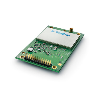
Photo: Trimble
The Trimble BD9250 dual-frequency receiver module supports Trimble RTX correction services and is designed to deliver high-accuracy positioning for high-volume, autonomous-ready applications in agriculture, construction, robotics and logistics. The compact receiver has an industry-standard form factor and pinout, allowing for easy system integration and configuration. Equipped with Trimble’s advanced ProPoint positioning engine, the BD9250 delivers robust and accurate positioning. It is compatible with Trimble RTX correction services or real-time kinematic (RTK) and supports GPS, Galileo, GLONASS and BeiDou as well as QZSS and NavIC. Support for the Indian NavIC S-Band signal is also available.
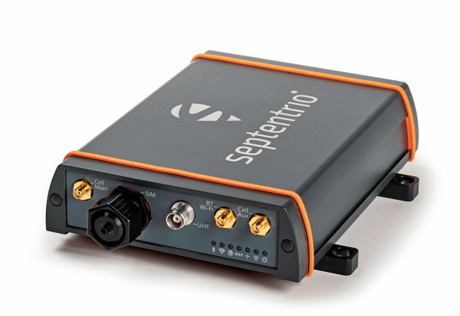
The AsteRx-U3 ruggedized GNSS receiver is the successor to the AsteRx-U for construction, mining and other machine control applications. It combines a triple-band precise positioning GNSS core with extended wireless communication features including Wi-Fi, UHF and 4G LTE, making it easy to fit it into any control system. The AsteRx-U3 offers low latency of under 10 msec with a high data rate, which allows machines to work rapidly and accurately. An IP68-rated housing, with fixing brackets and robust M12 connectors, enables quick installation.
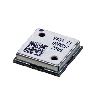
The M20071 integrated GNSS receiver module, measuring 9 x 9 x 1.8 mm, incorporates the MediaTek AG3335MN flash chip. The receiver tracks four GNSS constellations concurrently (GPS + Galileo + GLONASS + BeiDou). The 1.8-volt system power supply provides outstanding low power consumption. Its multipath algorithms improve position accuracy in inner-city environments. The onboard low noise amplifier provides good performance in weak signal environments such as wearable devices.
The Strategic Anti-jam Beamforming Receiver – M-Code (SABR-M) enables precise geolocation and strike capabilities in highly contested battlespaces. It integrates receiver technology with advanced antenna electronics in a small, hardened package designed to meet challenging performance requirements. It delivers accurate position, velocity, altitude and timing data, as well as strong protection against GPS signal jamming and spoofing. At 4.5 x 6 x 1 inches, the SABR-M meets size, weight, power, cost (SWaP-C) and thermal requirements for space-constrained military applications. It uses advanced beamforming technology to improve GPS signal reception and counter threat signals.
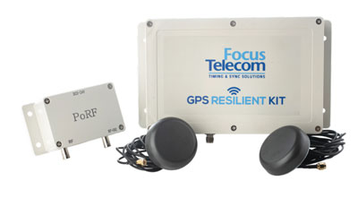
The GPS Resilient Kit (GRK) is a cybersecurity device that comes with two antennas for monitoring and protecting time-critical infrastructures. It can be integrated with any GNSS receiver, either as a retrofit or in greenfield deployment. The GRK features a proprietary interference filtering algorithm for maximum protection, up to 40-dB attenuation of jamming signals with the premium option. It requires minimal power consumption while providing cloud-based monitoring with real-time reporting of jamming attacks. It protects GPS L1 (C/A code) with a latency of 100 ns ±15 ns (fixed).
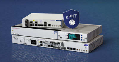
GBaaS enables providers to combat PNT cyberattacks
Photo: ADVA
GNSS-backup-as-a-service (GBaaS) enables service providers to help operators safeguard services that rely on positioning, navigation and timing (PNT). In-network timing based on network time protocols (NTP) and precision time protocols (PTP) are also increasingly vulnerable to cyber threats. GBaas is based on ADVA’s aPNT+ platform, which leverages a suite of technologies, including multi-band GNSS receivers and management software based on artificial intelligence and machine-learning. Service providers can offer ADVA’s aPNT+ protection as a subscription-based service as part of their service-level agreements.
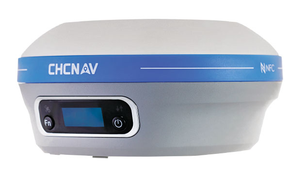
The i73+ pocket-sized receiver is a powerful and versatile receiver with an integrated UHF modem that delivers survey-grade accuracy in all jobsite configurations. It has 624 GNSS channels and the latest iStar technology and can be operated as either a base station or a rover. The i73+ is a highly productive NTRIP rover when used with a handheld controller or tablet and connected to a GNSS RTK network via CHCNAV LandStar field software. The receiver takes advantage of GPS, GLONASS, Galileo and BeiDou, in particular the latest BeiDou 3 signal, to provide robust data quality at all times.
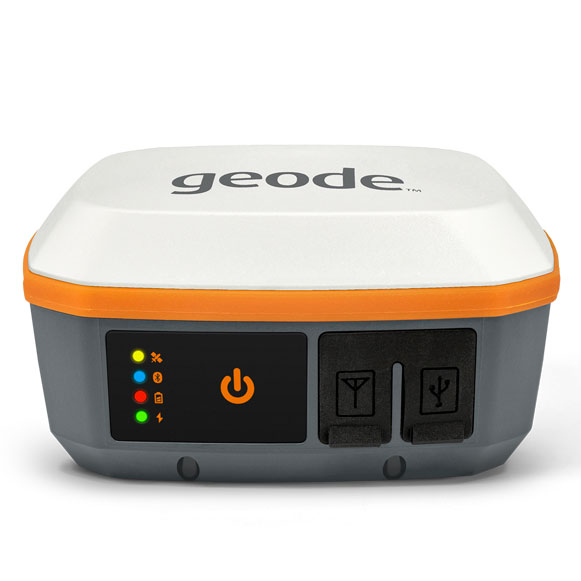
The Geode GNS3 GNSS receiver allows users to collect real-time GNSS data with sub-meter, sub-foot and decimeter accuracy options. With a scalable accuracy platform, users can purchase what they need now, while having the option to increase accuracy in the future. It offers sub-meter accuracy with a single-frequency antenna, while its multi-frequency antenna supports all constellations on L1, L2 and L5. Atlas L-band corrections allow the Geode to be used in water utility locating, agriculture and irrigation mapping, as well as mapping projects in remote locations where other correction services are not available. The Geode GNS3 can be used with Windows, Android, iPhone and iPad devices.
Improved colorization to contextualize point clouds
Photo: GeoSLAM
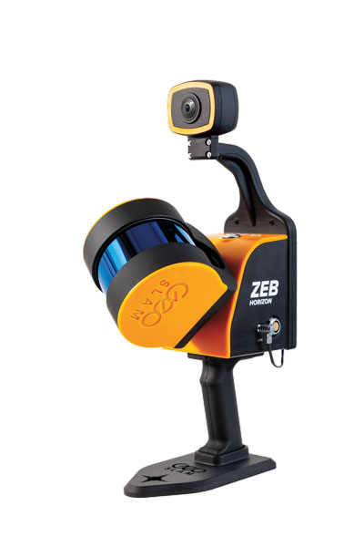
The ZEB Vision is a camera accessory for the ZEB Horizon system that can be used to capture 360° panoramic photography in 4K definition for point cloud colorization. Data is captured as the user walks through the area of interest. The ZEB Vision uses GeoSLAM’s SLAM algorithm to automatically and accurately position panoramic photos on a point cloud for an interactive viewing experience. The ZEB Vision attaches easily to the ZEB Horizon. The 4K resolution increases feature definition of objects within the point cloud, allowing for a new perspective on data by navigating within a virtual representation of an environment. This means industries such as architecture, construction and facilities can add real-world context to point clouds for the creation of CAD/BIM models.
The Leica Chiroptera-5 is a high-performance airborne bathymetric lidar sensor for coastal and inland water surveys. It combines airborne bathymetric and topographic lidar sensors with a four-band camera to collect seamless data from the seabed to land. Compared to previous models, the Chiroptera-5 provides 40% higher point density, a 20% increase in water-depth penetration, and improved topographic sensitivity for generating more detailed hydrographic maps. Its high-resolution lidar data supports nautical charting, coastal infrastructure planning, environmental monitoring and landslide and erosion risk assessments.
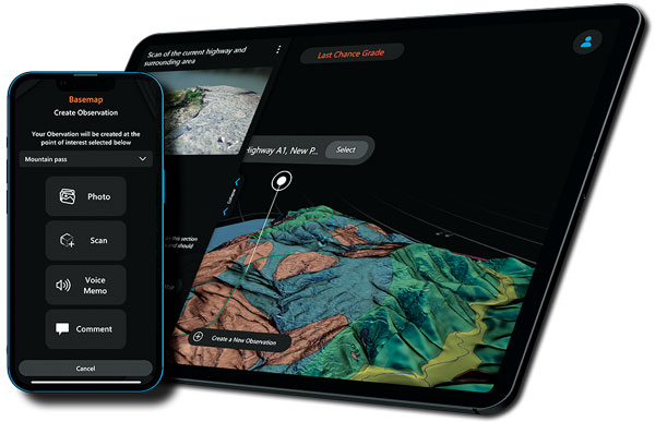
The Clirio application combines mobile lidar 3D scanning with smart remote collaboration tools to offer teams an end-to-end 3D solution to capture, organize, share and problem-solve. This is all based on real-time field observations and data, whether team members are on site or a continent away. Clirio is a set of mobile, web and VR/AR apps for instantly capturing, sharing, reviewing and resolving worksite field observations. At a field site, Clirio users collect notes, photos and 3D scans (using the laser scanner built into a new iPad Pro or iPhone Pro). These field observations are automatically geo-referenced within the map-based workspace and synced to a secure cloud workspace. An intuitive interface allows colleagues, managers, partners, or stakeholders to sort, review, compare, and act on field observations.
The Visual Parking System (VPS) by Bird is designed to keep track of scooter parking in a scalable, efficient and vandalism-immune way that requires zero infrastructure within a community. Powered by Google’s ARCore Geospatial API, VPS enables scooter parking with pinpoint accuracy. When parking a scooter, riders will be prompted to take a quick scan of their surroundings. The system seamlessly compares a rider’s images against Google’s data and Street View images in real time to produce the best available parking solution. Stationary objects such as buildings and signs are used as reference points, while more dynamic objects such as people and vehicles are disregarded. The near-instantaneous process results in a precise, centimeter-level geolocation that enables Bird VPS to detect and prevent improper parking with extreme accuracy, helping ensure Bird vehicles are only left in approved areas.
Supports Industry 4.0 with real-time visibility of assets
Photo: Pozyx
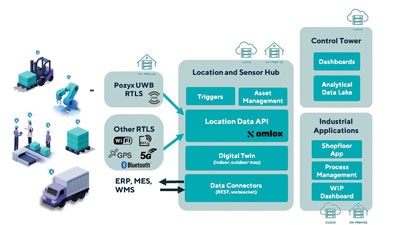
The Pozyx Platform is an asset tracking and identification solution for seamless indoor and outdoor tracking, following packages or other assets from trucks to their destination. It is based on the omlox hub, an open standard for real-time location systems that combines GPS data with data from ultra-wideband, 5G, radio-frequency identification, Wi-Fi and Bluetooth. The Pozyx Platform offers a seamless indoor/outdoor transition with zoom-in from a worldwide map to a detailed indoor map, showing highly accurate locations up to 10 cm. It is designed for smart manufacturing, providing a supply-chain solution that supports Industry 4.0. It tracks and identifies any asset, providing real-time data to facilitate warehouse and inventory control, keep track of critical tools, and slash lost asset costs.
Land surveying is an ancient practice, dating back at least 5,000 years to when Egyptian rulers used it to tax land plots. Over the centuries, it has been repeatedly transformed by new technologies — the compass (about 200 B.C), the theodolite (1550s), Gunter’s chain (1620), the sextant (1757), electronic distance measurement (1950s), and total stations (1970s). Then came GPS, followed by the other GNSS and corrections services.
Now comes sensor fusion, which aims to compensate for the limitations of GNSS — orbit and satellite clock errors, ionospheric and tropospheric delays, multipath, dilution of precision, urban canyons, jamming, extremely weak received signal, etc. — by integrating it with other sources of positioning data, including inertial measurement units (IMUs), lidar sensors and cameras. Even crowdsourced geolocation data collected with cell phones help expedite surveys by guiding surveyors to landmarks.
In the following article, representatives of five companies share their perspectives on recent advances in surveying and the remaining challenges.
Many More Satellites
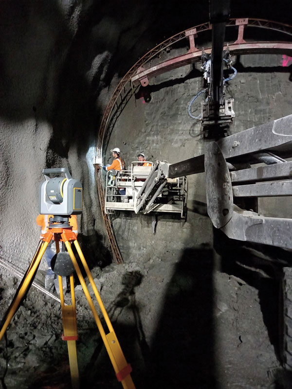
City Rail Link is New Zealand’s first underground rail network and the largest transportation project ever undertaken there. In this photo, taken at Karangahape Station, the Mined Tunnel Team installs a lattice girder secondary support structure using a Trimble SX12. (Photo: Link Alliance)
Compared to just a few years ago, there are many more GNSS satellites, signals and options for correction services. Over the past decade, the average number of satellites in view has more than doubled to more than 40 today. Some parts of the world have more than 70 satellites in view, said Boris Skopljak, vice president, Surveying & Mapping Strategy and Product Marketing at Trimble Inc.
“The developments in GNSS field systems have always been geared toward simplifying workflows, improving accuracies and increasing productivity,” Skopljak said. “In the last few years, we’ve seen that on a massive scale. In some of our materials, we no longer even quote how many signals our GNSS receivers are tracking.”
The vast increase in the number of satellites has extended high-precision applications to the robotics and automotive markets. The challenge now is “position solution,” not just GNSS, said Simon Peng, director of the Overseas Department at ComNav Technology. The improvements in the satellite constellations, antenna technologies and algorithms also enable surveyors and other users to obtain results faster and to operate in environments previously impervious to GNSS, such as under heavy canopy and very close to buildings.
“Our customers can now operate in environments where there is no virtual reference station (VRS) infrastructure or real-time kinematic (RTK), by leveraging precise point positioning (PPP) solutions, such as the Trimble RTX corrections service,” Skopljak said.
“Additional satellite signals and constellations (like Beidou),” Skopljak said, “improved antenna technology and continuously evolving algorithms are contributing to improving the RTX accuracy while bringing the convergence times to almost instantaneous in normal conditions and making technology available in more regions.”
“When I first started surveying, if we had a 12-channel receiver, that was doing very well,” recalled Jesse Huff, head of Sales and Marketing, JAVAD GNSS. “Now, we’re tracking 36 birds in the sky at one time with an 874-channel receiver. That’s phenomenal.”
Huff described a patent-pending feature called real-time post-processed kinematic (RTPK). “It combines RTK, PPK and PP techniques, with multiple core processing engines and a single solution coming out of that. It is impressive standing underneath a giant oak tree and surveying that monument with GPS and knowing what your accuracies are. We’re not even chasing RMS values; we can report the actual positional uncertainties, which is amazing.”
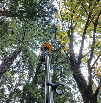
Pole tilt compensation enables surveyors to precisely and easily localize points that are difficult or dangerous to access. (Photo: ComNav Technology Ltd.)
“With so many signals and the new ways of how we compute positions based on PPP technology, we can almost globally get to centimeter-level positioning within a couple of minutes from just one global correction link,” said Bernhard Richter, vice president of Geomatics at Leica Geosystems AG, part of Hexagon. “Under optimum conditions, you can have almost an instantaneous global accuracy of a couple of centimeters.” In mature areas, he added, a local RTK network infrastructure enables achieving centimeter accuracy within a couple of seconds.
Galileo, Richter pointed out, will be fully operational in 2023 with great signals, though he’s “a bit skeptical” about the system’s target date for its high-accuracy service. “So, we will basically get global constellation corrections that allow us also centimeter-level positioning.” BeiDou has been fully operational since 2020. “GLONASS is more unpredictable,” Richter said. “It looks like modernization is slowing down a bit, in particular the CDMA developments.” Additionally, he pointed out, it is possible that one or more governments may decide not to use those signals, for military or political reasons. “It’s not the manufacturers who decide which signals to take.”
“In open-sky conditions, additional satellites have added redundancy — which is always good for position integrity — but it’s only when obstacles start to appear on the horizon, blocking out parts of the sky, that all-in-view RTK really comes into its own,” said François Freulon, Head of Product Management at Septentrio. When they did not have a full view of the sky, he recalled, GNSS users used to have to carefully schedule their work to coincide with times of high satellite visibility. “Nowadays, by using multiple constellations and signals, RTK can reach the parts that receivers in the past could not tread. More signals and constellations have also helped in easing the collection workflow for surveyors, making the capture of data in difficult conditions much quicker and more efficient.” New correction services are further simplifying the workflow “thanks to new positioning techniques, pricing business models and simplified network density.” However, corrections companies still face challenges in ensuring that centimeter accuracy can be uniformly achievable at a global scale.
Sensor Fusion
The ongoing evolution in computing power and communication technology “leads to many more sensor combinations,” Skopljak said. “We are not talking about GNSS alone anymore. We are talking about integrating a GNSS antenna, a receiver, an IMU, power and communications into a single compact housing.” The integration of inertial sensors makes it possible to localize the instrument rod tip when the pole instrument is tilted. “That allows our customers to measure more safely in dangerous environments.”
“We are reaching a maturity stage of what we can do only with GNSS,” said Richter. “It’s all about sensor fusion. The problem when signals are obstructed, that’s not solved, even though we can do positioning from Wi-Fi hotspots or from local pseudolites.” So, fusing data from cameras, lidar, GNSS and IMUs in better ways is the way to go and presents “a huge open research ground.”
For Richter, the challenge is not just positioning, the orientation of objects is almost as important as that, especially for such tasks as machine control. “It’s also about what you do with the data that you collect. Hexagon’s vision is of an autonomous future where we put data to work in connected ecosystems to boost efficiency.” However, he pointed out, this requires large amounts of data, such as those from aerial photogrammetry, lidar and mobile mapping systems used to create city models and digital twins of buildings. “If you really want a car to drive autonomously through a city with all the things that could happen, you must rely on a perfect replication of the real world,” he said. Other examples he cited are more efficient evacuation plans and flooding simulations. “GNSS will never be enough, but it will always be a very good enabler because it works.”
Classes of Receivers
JAVAD GNSS designed its TRIUMPH-LS Plus receiver to work under heavy tree canopy. (Photo: JAVAD GNSS)
Two decades ago, we would often group GNSS receivers by accuracy into three buckets: consumer grade, resource or mapping grade, and survey grade. As accuracy has increased for all GNSS receivers, the boundaries between those categories — especially between mapping and surveying — have blurred. “The performance of GNSS has increased so much that we are not using the traditional accuracy-based differentiation between surveying and GIS,” said Skopljak. “For mapping professionals, 10 years ago it was all about points, lines and polygons; now it is all about locating assets and adding the most accurate positions as attributes to those assets. For our survey and engineering customers, what matters is still geometry and working with the models to serve the connected construction in the field.” As for the pure GNSS technology stack, “we are seeing fewer differences between mapping and surveying receivers, but we are focusing on serving the customer in terms of product-as-a-service or as a productivity tool.”
Huff made two points. First, that “survey grade” does not necessarily equal RTK. “Some education needs to happen so that people understand RTK as a technique, not an accuracy. You can get poor accuracy and poor fixes with RTK, even when you’re using good techniques. So, when I say ‘survey grade’ I’m still talking about the full frequency receivers, using all available signals.” Second, that consumer-grade receivers, such as the chipsets in our phones and computers, do not require the same robustness as professional ones. “While they may be achieving the same precision, surveyors must be able to defend their position in a court of law.”
Huff cited the “phenomenal” success of the simultaneous localization and mapping (SLAM) movement with all kinds of positioning challenges. “From a survey perspective,” he said, “we’re dealing with a much more feature-rich dataset than we were even just 10 years ago, with everybody having some type of GPS device on their phones. There are location tags on everything. That creates evidence for the surveyor to be able to go out and recreate things, reduce trips to the field, reduce rework times — all those things that make a surveyor’s life much easier.”
Surveyors now can fly aerial surveys of hundreds of acres in less than half an hour using drones with RTK, Huff said, instead of having to wait for the flying season with traditional airborne photos. If needed, they can pick a few ground-control points for ground truthing. “We’re able to do that with photogrammetry techniques, but using GNSS technology to position drones, whether it’s real time or post-processing, has definitely made surveying jobs easier.”
Correction Services
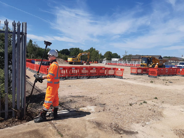
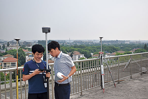
The adoption of GNSS in construction is growing and receiver manufacturers are making it easier to use their equipment in the field. (Photo: Leica Geosystems)
Correction services — such as satellite-based augmentation systems (SBAS), the ground-based Wide Area Augmentation System (WAAS) and the European Geostationary Navigation Overlay Service (EGNOS) — make a big difference along with PPP and similar techniques when base stations are not available. “We have the whole CORS network here in the United States,” Huff pointed out. “We also have services available from the National Geodetic Survey.”
Those who don’t want to have to fully engage in post-processing can upload their data to the Online Positioning User Service (OPUS), AUSPOS (a free online GPS data-processing facility provided by Geoscience Australia) or other corrections services that will post-process positioning data. “It has made it more accessible for all the surveyors all the way around, especially as the technology has improved and the cost barrier to entry into a survey-grade GPS receiver has come down significantly as well,” Huff said.
Growing Adoption of GNSS
The greater number of satellites in orbit significantly reduces convergence time and increases the accuracy of the solution, which makes the technology much more user-friendly for professionals and nonprofessionals alike.
For surveyors and mapping professionals, the increasing levels of GNSS performance means that “GNSS continues to be the dominant equipment and they can operate in challenging GNSS environments while still meeting the accuracy and precision requirements,” Skopljak said. GNSS usage is also growing in such industries as agriculture, construction, transportation and logistics. “Now, when farmers are on a combine, they don’t have to wait for an RTX or PPP solution to converge for 20 minutes. The solutions just work, and they can perform their task.”
Skopljak also pointed to “more flexible business models, such as pay-as-you-go or equipping seasonal workers or fleets of spatially enabled consumers to use GNSS,” that reduce the required upfront investment. “Surveyors now can go for longer and be productive in more areas where they could not use GNSS technology before. The non-surveying professionals — such as in natural resources, farming or construction — now can just turn on the machine and things work for them. They don’t have to worry about coordinate transformations and things like that.”
“Twenty years ago, when RTK and networks kicked in and then became popular, we were discussing whether it was the end of the automated total station,” Richter recalled. “Yet, the number of automated total stations has grown ever since.” To him, this is proof that GNSS alone will never solve all surveying problems. GNSS’ weak signal will always require surveyors to supplement it with other sensors, such as reflectorless total stations. “These instruments always need to work in harmony,” Richter said.
Success on both construction sites and in machine control require a very good robotic total station and a very good GNSS receiver, Richter said. “The simple problem of leveling a pole is actually solved, and we are using the technology that we developed for tilt-compensating GNSS receivers. We’re leveraging this now into the world of the total station.” This has solved one of the fundamental problems surveyors have long had, because they no longer need to level up and can measure tilted poles with a total station and with a GNSS receiver. “We have also made it very seamless for surveyors to switch between using GNSS receivers and total stations,” Richter said.
Geneq Inc. has released the SXblue SMART to meet the requirements of professionals looking for an accurate, flexible smart antenna for field work.
The SXblue SMART features a GNSS engine capable of quickly tracking all-in-view GNSS signals. Its design includes interference mitigation technology and optimization for handling a wide frequency band.
Weighing 850 g including battery, the SXblue SMART is compact, supplying the accuracy, ruggedness and maneuverability needed by surveying professionals. Its radio link is based on the Farlink protocol that allows a range of up to 8 km, a performance achievable while reserving a wide bandwidth for transmission of real-time kinematic (RTK) data.
In addition to a tilt sensor for measurements in hard-to-reach places, the SXblue SMART features a high-performance attitude measurement module that can detect and measure movement of the device. An integrated inertial measurement unit provides even more accurate and stable measurements and increased productivity. The SXblue SMART also has a built-in thermometer for monitoring and controlling its internal temperature.
Compared to the company’s previous products, the SXblue SMART has improved communication features, including near-field communication that facilitates close communication with a controller or mobile phone equipped with this technology.
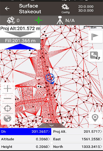
Tersus GNSS has updated its surveying smartphone app, Nuwa. The latest version includes features such as vector map import and digital surface stakeout.
The Nuwa app runs on Android and is reliable, and easy to operate. It has rich and powerful functions that can help surveyors complete measurements more efficiently and accurately.
The app is designed to work with the David and Oscar GNSS receivers from Tersus GNSS, plus other receivers that support NMEA-0183.
New features in Nuwa version 2.3.3.2 include:
Vector map import and stake. The new version supports importing vector maps in DXF, LandXML, KML, and KMZ formats in the import module, optimizes the loading speed of vector maps for display in the Survey and Stakeout interface, and allows direct clicking to select points and lines on vector drawings for staking.
Digital surface stakeout. The new version supports importing DXF files containing 3dface entities and LandXML files containing surfaces, manually selecting points to form Delaunay TIN, and entering surface offsets for fill and cut value interpolation calculations in Surface Stakeout.
Update version description. Now, when receiving a version update, the highlights of the latest version are displayed directly in the application, including essential or market-focused features and fixes for issues.
Existing features of Nuwa include:
Ability to configure base, rover and static surveys
Graphical interface with background map (online/import)
My previous column highlighted that orthometric heights in NAPGD2022 will be defined through ellipsoid heights and a geoid model, such as GEOID2022. Therefore, changes in the geoid model will be very important to users estimating orthometric heights using GNSS. I briefly described the geophysical reasons for changes in the geoid that affect the orthometric height of a mark.
For the past four years, I have discussed in my columns the tasks associated with the new, modernized 2022 reference frames. It’s now the middle of 2022, so where are the new reference frames? Well, on June 9, Dru Smith, NSRS modernization manager for the National Geodetic Survey (NGS), provided an update on the status of the modernization in a webinar. The Powerpoint slides and video of the presentation can be downloaded from the NGS website under the following title: It’s 2022…Are You Done Yet? I will highlight some of the items from the webinar, but I encourage everyone to download the video and listen to the webinar.
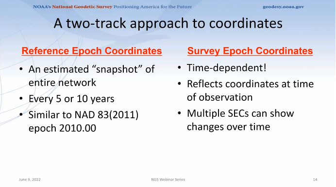
First, Smith mentioned that NGS will be providing new types of coordinates. The NGS denotes this as a two-track approach to coordinates: Reference Epoch Coordinates (REC) and Survey Epoch Coordinates (SEC). See the box below.
New types of coordinates (Image: NGS June 6 webinar)
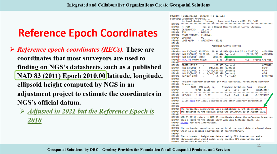
Reference Epochs Coordinates (REC) are defined in NGS Blueprint for the Modernized NSRS, Part 3 as coordinates computed by NGS in an adjustment project to estimate the coordinates at one of the official reference epochs that NGS will define in 2025. RECs are similar to coordinates computed by NGS in a nationwide adjustment project such as the National Adjustment of 2011 (see the box below).
NAD 83 (2011) epoch 2010.00 coordinates (Image: NGS)
NGS has not determined what data will be included in the first iteration of RECs. For the 2020.00 project, the current cutoff date for incorporating data is Dec. 31. Users can submit the data to NGS via OPUS projects and the OPUS-Share tool. To increase the submission of GNSS observations on marks, NGS has developed a beta OPUS-Projects 5.0 webtool that will allow real-time kinematic and real time network (RTK/RTN) observations to be submitted.
As previously mentioned, at this time, the NGS has not determined the cutoff for the earliest data to be included in the determination of the 2020.00 RECs. The agency will be conducting experiments to determine the appropriate cutoff date. These coordinates will require an intra-frame velocity model (IFVM) to generate the RECs at the specific reference epoch.
As of February 2021, based on NGS’ Blueprint for the Modernized NSRS, Part 3, version February 2021, the following is the agency’s policy with regard to RECs:
For a given mark and a given reference epoch, the REC will never be changed–except to correct a blunder.
This does not prevent NGS from adding new RECs
on points with new data that have not yet had an REC computed
for marks that do not have an REC in the most recently passed reference epoch, a new REC can be computed and added to the NSRS.
Survey epoch coordinates (SECs) are defined as coordinates computed by NGS at a specific survey epoch. Users will submit their data and its metadata to NGS, and NGS will then check, adjust and define the coordinates at one “survey epoch.” These coordinates will be “part of the NSRS,” Smith said. NGS is computing coordinates in this manner to provide the best estimate of the coordinates at any mark at a specific moment in time, which is very important in areas influenced by crustal movement.
So, how will NGS process and generate these SECs?
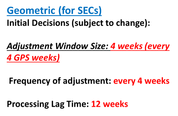
Survey epoch coordinates (SECs) are designed to provide time-dependent geodetic coordinates. Therefore, NGS has to choose some time span in which all observations will be processed together to yield a single SEC of a mark. NGS denotes this time span as a “geometric adjustment window.” NGS wants the adjustment window to be short enough so that movement of a mark did not occur between repeat observations (or was small enough to be ignored) and long enough for users to efficiently and effectively collect redundant observations for submission to NGS (see the box below).
One or more GNSS occupation(s) over a single mark will be processed into one survey epoch coordinate when all occupations take place within one geometric adjustment window.
If a user submits two occupations on one mark, but they happen to fall in two consecutive geometric adjustment windows, NGS will use them to create two distinct survey epoch coordinates. Each SEC will be based on one occupation.
Future columns will provide more explanation about this concept of a geometric adjustment window and how NGS will process the data to generate survey epoch coordinates.
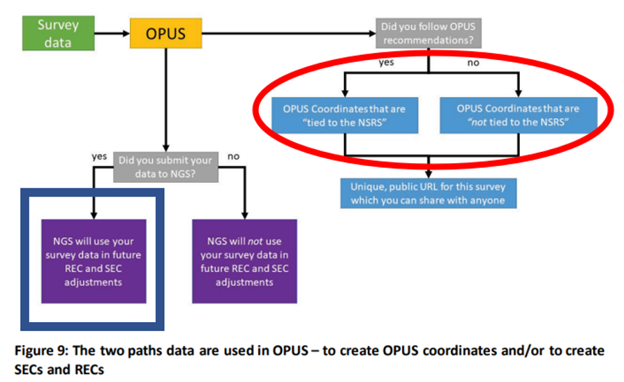
NGS is developing models and tools for users to submit data to NGS to compute coordinates — including OPUS coordinates, reference epoch coordinates and survey epoch coordinates. Figure 9 from Blueprint for the Modernized NSRS, Part 3, version February 2021, is a schematic that shows the flexibility NGS is building into an OPUS-type webtool. Basically, if users follow NGS guidelines and rules, and submit their data to NGS, then NGS will compute and publish REC and SEC coordinates (see the blue outline in the box below). If users only want to compute OPUS coordinates, then they can use NGS’s webtool without submitting the data to NGS (see the red outline in the box below).
Building flexibility into OPUS (Image: NGS)
Dru Smith’s June 9 update on the status of the modernization provided a mockup of how users will be able to retrieve data using their web browsers — a prototype is being developed. The data will also be available in downloadable form such as an XML file for users to input the data and metadata into their programs or databases. I recently discussed some of this material at seminars I presented at the Florida Surveyors and Mapping Society’s 67th annual conference held in Palm Beach Gardens. The participants were very interested in the prototype, but really wanted to learn more about the format and process of the downloadable XML files. I’m sure future NGS webinars will address this topic. I emphasized to the group that they should watch the entire presentation and provide feedback to NGS. As mentioned above, Powerpoint slides and video can be downloaded from the NGS webinar website.
The boxes below highlight a few of the options NGS is considering. The box “Data Delivery – Prototype” is an example provided by Smith during his webinar. It should be noted that the images of the prototype are not included in the downable slides, but they are part of the video. The images presented in this column are screen captures from the video.
Data delivery prototype. (Image: NGS)
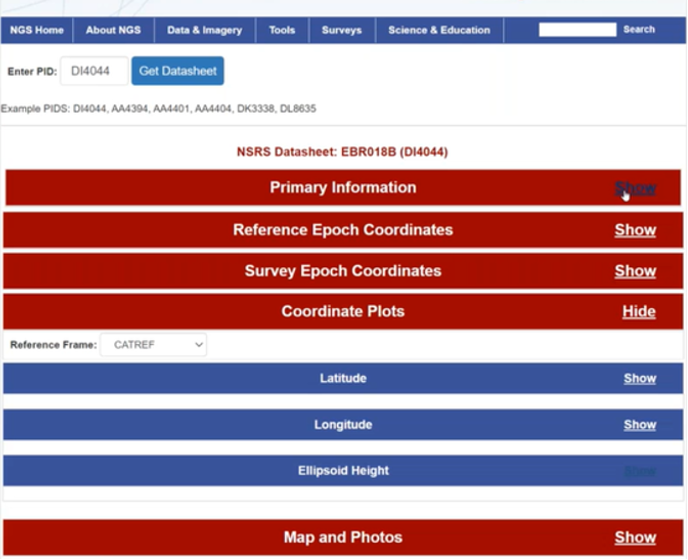
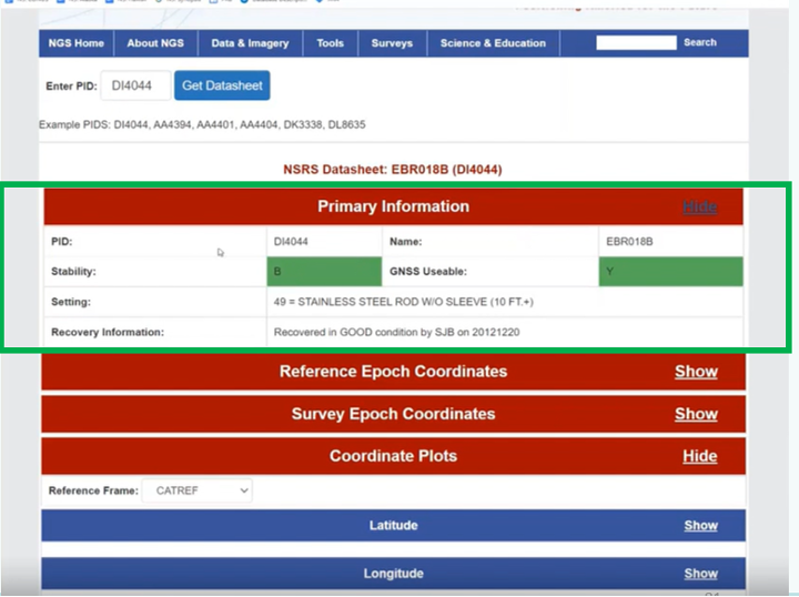
The box below provides some of the basic information of a mark, such as its PID, name, stability, GNSS usable code, setting and the latest recovery information. Again, this is a prototype, so users should feel free to send feedback to NGS. NGS wants to generate a usable product, and is interested in user feedback.
Primary information prototype. (Image: NGS)
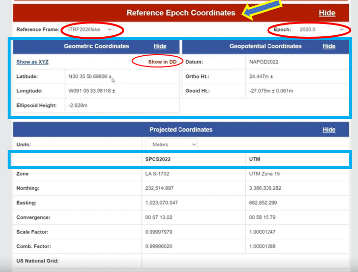
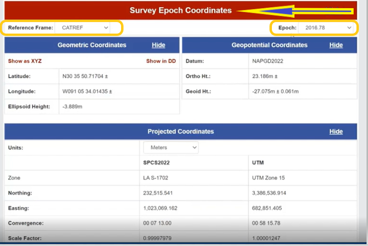
As previously stated, NGS is implementing a two-track approach to coordinates: publishing REC and SEC. The box below provides the REC information of a mark when a user clicks the “Show” button. As shown in the diagram, the reference frame and epoch are provided, as well as the geometric coordinates (latitude, longitude, ellipsoid height) and geopotential coordinate information (NAPGD2022 orthometric height and geoid height).
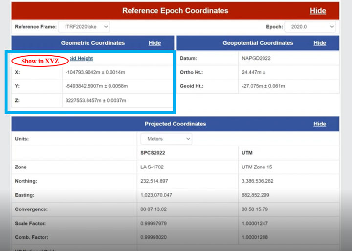
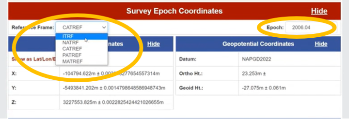
NGS provides an option for individuals who want the geometric coordinates in the X, Y, Z format (see the box below). Remember, this is only a mockup of a prototype, to give us an idea of the direction NGS is going with its data delivery system in the new, modernized 2022 NSRS.
REC Shown in X,Y,Z. (Image: NGS)
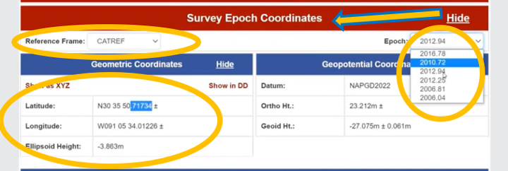
Similar to the REC, the prototype includes SEC. For a mark, the latter are different from the former because SEC are computed at the epoch of the survey observations (see the box below).
The box titled “SEC in CATRF – Prototype” is an example of a mark in the CATRF reference frame and the survey epoch of 2012.94. As indicated in the diagrams, users will be able to select the reference frame (ITRF, NATRF, CATRF, PATRF and MATRF) and the survey epoch.
SEC in CATRF – Prototype
Option to Select Survey EpochOptions to select reference frame (Images: NGS)
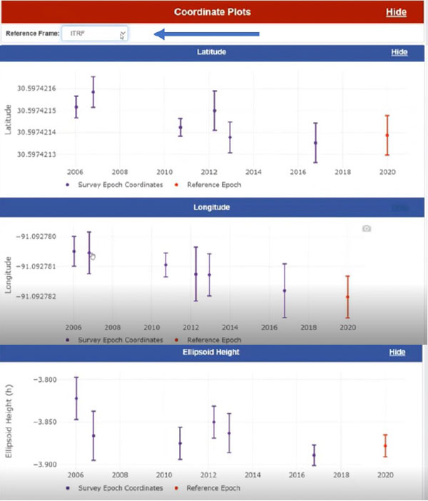
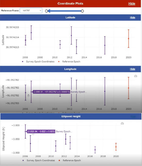
Another feature of the data delivery system is that it provides plots of a mark’s survey epoch coordinate values at different epochs. In the example shown in the box below, the plots provide values of a mark’s latitude, longitude and ellipsoid heights based on each survey epoch data. The user can select various reference frames of the mark to understand the change based on the reference frame.
Coordinate plots in ITRF prototype. (Image: NGS)
The box below clearly shows a slope in the changes in coordinates based on survey epochs, especially in the longitude. This is the plate rotating in time. You can see the changes in latitude, longitude and ellipsoid height in the NATRF reference frame for the same mark. The latitude and longitude plots do not show a slope because the plate rotation is removed using a model to change from the ITRF reference frame to the NATRF reference frame. That said, the ellipsoid height plots look the same because the rotation model does not change the ellipsoid height.
Coordinate plots in NATRF prototype. (Image: NGS)
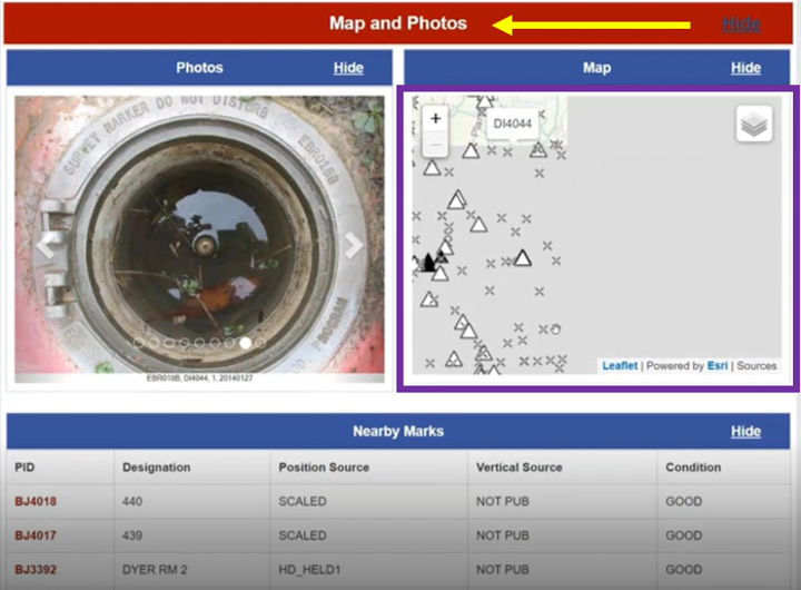
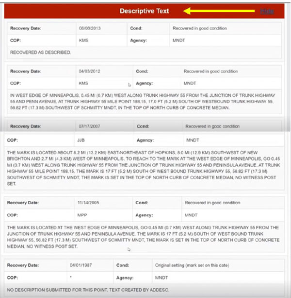
The prototype also provides maps, photos and descriptive text of the mark.
Map and photos of a mark in the prototype. (Image: NGS)Descriptive text prototype (Image: NGS)
Some of this data delivery output may seem familiar to users who have used the NGS beta routines (see the box below).
Beta Routines
Beta routines (Image: NGS)
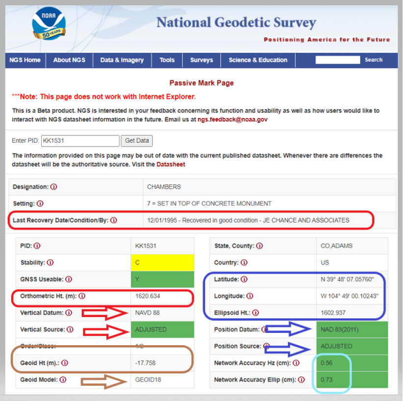
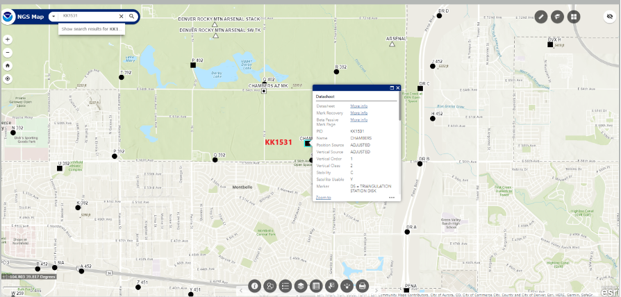
For example, the Passive Mark Page Webtool provides the coordinate information for a mark. My October 2020 column described the tool is detail. See below for an example of the passive mark tool.
Beta Passive Mark of KK1531 (Image: NGS)
The NGS Beta Map routine enables users to link to NGS datasheets, the passive mark tool and mark recovery, as well as connect to OPUS Shared Solutions and the NOAA CORS Network. See below for an example. It also provides a measuring tool, multiple basemaps and the ability to export data. My December 2021 column described the NGS Beta Map in detail.
Example of NGS Beta Map Routine for KK1531 (Image: National Geodetic Survey)
Only three years remain before the release of the new, modernized NSRS. I encourage everyone to try all of the beta products, and download Dru Smith’s June 6 webinar for a better understanding of the agency’s current thoughts on how it will provide data to users in the new, modernized NSRS. As for all the NGS beta products, the agency would like users to try the tools and provide feedback on what they liked and what they didn’t like, as well as any additional information you need or would like to see. The NGS is trying to develop tools useful to everyone, but that won’t be possible unless they hear from users.
The following statement on NGS beta products explains how to provide feedback and why it is important:
“This is a beta product. NGS is interested in your feedback concerning its function and usability as well as how users would like to interact with NGS datasheet information in the future. Email us at [email protected].”
Trimble has introduced the Trimble X12 scanning system to the geospatial scanning portfolio. The X12 integrates intuitive Trimble software for precise data capture and in-field registration with 3D laser scanning and imaging hardware technology from Zoller+Fröhlich (Z+F), combining the expertise of two industry leaders into a single solution.
The Trimble X12 can be operated by using Trimble Perspective field software installed on a Trimble T10x tablet to enable registration and refinement of scans in the field, ensuring project accuracy and completion before leaving the jobsite. Users can also leverage Trimble’s customized onboard software menu to configure and operate the scanner.
Data is exported from the field and processed in the office with Trimble RealWorks software or third-party software. Final deliverables can be shared online with clients and stakeholders using Trimble Clarity, a browser-based data collaboration and visualization tool.
Transforming high-quality 3D data into decisions — such as using scans, models and imagery to determine the structural integrity of aging infrastructure — is streamlined with the Trimble X12 because the data can reside within the Trimble software ecosystem. This allows users to easily visualize, manage and evaluate the project throughout the entire workflow, even for beginners and new users to scanning technology.
With features including range (from 0.3 up to 365 meters) and scan speed of up to 2.187 million points per second, the Trimble X12 produces scan data and images with high quality and clarity, complementing the Trimble X7’s capabilities within the scanning product portfolio.
“The Trimble X12 puts the most advanced 3D scan and image capture within reach for a variety of skill levels,” said Jacek Pietruczanis, business area director for Scanning and Mobile Mapping, Trimble Geospatial. “The system enables advanced scanning professionals to improve their productivity with top-of-the-line performance and efficiency gains, while those new to scanning can easily unlock this advanced capability with the touch of a button.”
Jason Poitras (left) and Marc Veinotte of MicroSurvey test a multi-constellation OEM rover with the FieldGenius for Android field controller software. (Photo: Gavin Schrock)
It’s about more than advances in technology — peak times demand peak productivity
Trusty legacy rovers have served surveyors well. Under the right conditions and with proper procedures, a 20-year-old rover might still deliver precisions that could match the latest and greatest.
We’ve become so used to the limitations of legacy gear that we’ve built our workflows, expectations, and job estimates around them. However, in the past few years, the state of GNSS rovers has experienced a sea change, with gains in productivity, the ability to work in mixed environments, ease of use, and increased speed, repeatability and reliability — these developments have come at an opportune time.
Peak Times
Surveying always has been a feast-or-famine prospect; the rises and dips in economics are felt sharply within the profession.
In many places, there is more work than surveyors can accommodate, with competition to recruit and retain enough field personnel to meet demand. It is unclear how long this peak will last. Surveying firms recognize this and do their best to take on as many projects as they can.
Staffing is an acute challenge. Firms have had to dip into incentives beyond the usual pay and benefits packages to attract and retain qualified field personnel. Having the latest gear is a definite plus. Experienced surveyors know much they struggled with legacy gear: GPS-only or GPS + GLONASS only, slow processors, poor multipath performance, and field-data-collector operating systems and software that are obsolete or no longer supported.
Despite the immediate need, it’s generally less desirable to hire people with no surveying experience and train them from scratch. However, newer rovers and field software often do not have the same steep learning curve posed by legacy systems and methods.
Productivity Now
It is hard to say how much of the productivity gains, stated by various manufacturers for their newest systems, will be realized for your specific workflows, but simple testing can give you an idea.
When surveyors try out new rovers, they tend to find themselves so impressed by the first unit tried, they conclude it must be “the best” and eschew due diligence in the selection process. That aside, I believe it is safe to say that there is a near across-the-board productivity improvement with the latest generation of rovers.
Most rovers now provide no-calibration tilt compensation. (Photo: Gavin Schrock)
A Confluence of Factors
We haven’t seen such a sea change in GNSS rover technology in decades; most gains have been incremental. Similar jumps in the past included going from the static-only world to real-time and the first additional constellation beyond GPS.
While the early days of GLONASS were rocky, and most manufacturers were hesitant to productize an unreliable and noisy solution, it did eventually improve. The effect of nearly doubling satellites in view translated to productivity gains. But that was two decades ago.
The recent advent of true, multi-constellation GNSS has had a profound impact on the state of rovers. In 2020, both the Galileo and BeiDou constellations reached a full level of global coverage and signal integration.
Many rovers were already equipped to utilize some (but not all) of the newest satellites and signals. Interface control documents (ICD) for some of the signals have only been released by the constellation providers in the past few years. ICDs provide signal specifics that manufacturers need to integrate them into GNSS solutions.
Some rovers (and base receivers) developed four or more years ago may not be able to take advantage of the full complement of signals. And many did not have the processing power to utilize so many signals from so many satellites in real-time solutions.
By contrast, nearly every new GNSS board released in the past few years has greatly increased processing power, often double that of legacy gear.
Newer rovers are able to work better in sky-view-challenged and multipath hazard-prone places than rovers from only a few short years ago. And it is not just about the total number of channels on a rover datasheet, it is about how many are actually being utilized, how much of that data the processors and real-time kinematic (RTK) engine can handle, and how modernized signals are being leveraged.
Modernized signals are yielding additional advantages. The expected benefits of L5 for the GPS constellation have been widely promoted. L5 was designed to be robust enough for certain safety-of-life applications. The L5 signal is being deployed incrementally to the GPS constellation and should be broadcast from 24 satellites by 2027.
Modern receivers incorporate multi-GNSS signals that can improve performance under tree canopy. (Photo: Gavin Schrock)
I have heard surveyors say they won’t bother upgrading until L5 is complete. But wait — two other constellations already have third-signal capabilities. Indeed, there are 3, 4, 5, even 6 usable signals (in the case of Galileo) already available — modernized, robust signals.
Although L5 will only make this better, you can reap the benefits of signal modernization right now. Some of the innovation put into these modernized signals contributes to reducing certain sources of error. For instance, the Galileo E5a-E5b AltBOC — multiplexing signals in a wide band — is particularly beneficial for dealing with multipath.
Rovers have evolved in other ways besides multi-constellation integration. The decades between these sea changes brought developments such as electronic bubbles, better operating systems, and automation of some functions, but essentially the form factor and functionality of a surveying rover has not changed much. There have been some gadgets and gimmicks along the way, but otherwise rovers had remained pretty much standard in those intervening years.
Real-time precise-point positioning (PPP) has matured to the point that it could be viewed as survey-grade (at least in the horizontal). The delivery of clock, orbit and other data broadcast from geostationary communications satellites (as a service) for PPP means that, for many applications, high-precision positions can be processed by a rover over much of the globe — no base, no radio, no network and no cell phone connection required.
Once research and development removed the lengthy convergence times that plagued legacy PPP, it became commercially viable for many applications. Commercial providers such as Trimble (RTX), Hexagon | Leica (SmartLink), Hemisphere GNSS (Atlas) and others provide subscription services for surveying, construction, agriculture and the growing autonomy market. Most new survey rovers have a PPP option.
Multi-sensor integration, particularly of inertial measurement units (IMU), is becoming standard on new rovers. While there was some value from magnetometer-oriented tilt compensation in the past (though it could be cumbersome and somewhat unreliable), it served as a precursor to modern-day integrated GNSS/IMU no-calibration tilt.
The first no-calibration tilt system hit the market as recently as 2017; now it is hard to find a rover without it. Accessing hard-to-reach points and improved stakeout workflows are some of the benefits of tilt compensation. The development of reliable IMU/GNSS processing was also the key to fully integrating camera-based offset point capture — and soon other sensors such as lidar might be incorporated.
Market Choices
Another set of changes in the high-precision GNSS industry coincided with the above developments, growing a more competitive marketplace. This equates to more choice. The secret sauce of high-precision GNSS is no longer in the hands of the few. The glass floor has been broken, with more rovers than ever available.
Many tiers for choice have emerged.
The Top End. The manufacturers traditionally considered to be the top end continue to innovate and are usually the first to productize developments such as multi-sensor integration and PPP. They continue to lead in integrated surveying solutions, track record, performance, quality, service, support and peer user networks — which continues to appeal to many users. However, they also have second-tier offerings to suit various markets, regions and value propositions.
Whether to Use OEM Devices. For many users, there are compelling reasons to stick with top-end solutions, but there always has been room for other price point options. Until recently, most lesser-known rover brands exclusively integrated GNSS boards from a handful of well-known original equipment manufacturers (OEMs) such as Trimble and NovAtel. Sometimes new developments hit the OEM market quite rapidly — for instance, IMU integration. These third-party manufacturers may add their own touches, but in effect, nearly every rover out there offered a narrow set of DNA — until recently.
Rolling Their Own. Globally, technical universities are graduating GNSS engineers at an unprecedented rate; the prospect of mass applications such as vehicular autonomy and robotics are driving demand. With this expanding pool of engineers, it is now much more practical to develop GNSS solutions from scratch and to fully leverage multiple constellations.
Some third-party manufacturers began working with OEMs but have started developing their own boards and related technologies. I’ve tried several, and performance is, in most cases, as good as that of new boards from traditional sources..
The Rise of Mid-Price Rovers. There are a growing number of breakout rovers from lesser-known brands or rebranded models. These are about half the price of some of the top-end models, yet performance is in most cases nearly par. Some include OEM boards, or the new wave of independent boards.
I’ve seen a sharp rise in the popularity of mid-level rovers among small and mid-sized firms. However, there has not been a corresponding drop in sales of top-end rovers. It seems that surveyors are simply buying more rovers during this peak time.
Receivers-as-a-Service. Another approach for surveying and asset-mapping rovers is pay-as-you-go. This means you do not have to make large up-front investments in hardware. Instead, you pay for high-precision capabilities through subscriptions or tokens when you need it. This can be a good choice for occasional or seasonal users.
One example is Trimble’s Catalyst system. For Catalyst, the hardware investment is an inexpensive antenna, and then you access a subscription service via your mobile field data collector, tablet or smartphone to activate the software-defined receiver (SDR).
Another such model is Flex. With Flex, you have the option to pay full price for the full receiver/antenna to operate as a conventional rover. Alternatively, you can choose to pay a lower up-front price for the rover and use tokens to activate the high-precision capabilities.
Surveyors should put new rovers through their paces before choosing. (Photo: Gavin Schrock)
Low-Priced Rovers. Two external factors have fostered a mini boom in low-cost rovers: R&D for mass markets such as autonomy, and RTK/post-processed kinematic (PPK) solutions for drones, which are often used to reduce the need to set ground control points.
In both segments, inexpensive and often small GNSS boards have been developed. For drone applications where a base was needed for RTK/PPK methods, developers sometimes took the same GNSS board in the drone and packaged it as a base. It did not take long for some of these developers to package the rover for surveying or asset mapping (with geographic information system, or GIS).
While these rovers can perform just as well as top-end or mid-priced rovers in optimal conditions, they may struggle in mixed environments. I’ve tried some, and I can see why every surveyor I’ve asked about performance adds “for the price” to their assessment.
Other developers have taken this a step further, selling a bare-bones rover for less than $1,000, though these can take a lot of tinkering and extra attention to fit into a production workflow. There are even folks creating do-it-yourself rovers. I am not seeing many large firms, who have high-ticket projects and need to conduct integrated surveying, opting for lower priced systems.
We are riding a new wave of GNSS rovers, awash with more choices than ever. In this period of increased demand for surveying services, it might be a great time to upgrade and boost productivity.
New Players
A “roll your own” example is Tersus GNSS, which has designed and manufactured in-house GNSS boards and RTK engines since its inception in 2014. I asked Winston Wen, founder and CEO of Tersus, why they chose this strategy.
“I’m a hardware guy; electronics, computer science, signal processing, etc.,” Wen said. “In 2014, I took a look at the price and portfolios for high-precision, and for equipment for surveyors — the price point looked exceptionally high. From my point of view, it looked like there was room for a new player, and I felt we could do better. There are also growing markets for applications for high-precision GNSS, such as the internet of things (IoT) and autonomy.”
Tersus has experienced solid reception for its products globally. I asked Wen if he felt GNSS for surveying has reached a new level of performance. “Yes, nowadays with 50 satellites, that is huge. Surveyors will be very happy with performance, especially in environments with limited sky view. At this time, there don’t appear to be any new signals announced, so rovers bought today should be top performers to, say, 2025 and beyond.”
Industry Insights
GNSS executives told Gavin Schrock about recent developments in their companies.
Neil Gerein, Senior Director of Marketing,
Autonomy & Positioning Division, Hexagon
As satellite constellations were modernized, GNSS receivers kept pace to offer multi-constellation and multi-frequency capabilities to culminate in the latest technologies in PPP corrections.
For example, Hexagon’s RTK From the Sky technology is able to achieve highly available corrections with centimeter-level accuracy globally. However, modern GNSS receivers also offer other benefits, such as interference mitigation and spoofing detection for improved positioning robustness, multipath mitigation, and more powerful sensor fusion.
Miles Ware, Vice President,
Marketing & Global Customer Care, Hemisphere GNSS
Much like the constantly evolving world of smartphones, tablets, and computers, the improvements in multi-constellation GNSS receiver performance have been significant, even over just the past few years.
Many legacy rovers, bases and reference stations that are older than four years cannot track some of the newest signals, such as from BeiDou Phase 3 satellites. This means some of the highest performing signals available are now accessible to many users. As fewer BeiDou Phase 2 satellites continue to transmit, many legacy receivers will no longer have the performance they once did.
With upcoming services such as OSNMA (the Galileo GNSS data authentication service) and global PPP signals, many receivers from a few years ago do not have the CPU capacity to employ them. Today’s GNSS engines track more satellites, more signals per satellite, and have more CPU to perform advanced operations, all while consuming the same or less power than previous generations.
Francois Martin, Vice General Manager,
CHC Navigation
The latest GNSS RTK rover technology evolutions are based on the maturity and enhancement of satellite navigation systems, as well as the integration of IMU sensors into the receivers.
The most recent generation of our GNSS rovers, such as the CHCNAV i83, is based on the sophisticated iStar algorithm that significantly improves the efficiency of GNSS satellite signals tracking for unmatched performance in GPS, GLONASS, BeiDou, Galileo and QZSS constellations, utilizing all available frequencies, including BeiDou 3.
Moreover, the fusion of GNSS and IMU technologies enables centimeter-level positioning, maintains fixed and reliable RTK accuracy, and collects points faster than ever before, even in challenging conditions. GNSS survey productivity is increased by up to 30%, and the user base expands from experienced users to new users such as construction site foremen.
Gavin Schrock, PLS, is a practicing land surveyor, the operator of a cooperative real-time GNSS network in Washington state, and a technology writer.