Category: Survey

  • Juniper Systems Pulls Cedar Tree Under Its Banner

    Juniper Systems Pulls Cedar Tree Under Its Banner

    CT4-Handheld-W
    The CT4 and other rugged handhelds by Cedar Tree Technologies will now be available through Juniper Systems.

    Juniper Systems is merging its subsidiary company, Cedar Tree Technologies, into Juniper Systems. The move will allow customers to purchase Cedar’s Android-operated rugged handhelds directly from Juniper Systems.

    Juniper Systems launched Cedar Tree Technologies as a rugged handheld company in August 2014.

    “With a reputation for top-of-the-line, ultra-rugged handheld computers, Juniper Systems aimed to expand its products to meet the needs of customers who may not need the outstanding level of ruggedness or support that Juniper handhelds provide. And that’s how Cedar Tree Technologies began. Cedar handhelds lie somewhere between consumer devices and Juniper Systems’ ultra-rugged handhelds, providing a mesh of both ruggedness and affordability,” said a statement from the company.

    Cedar handhelds run on the Android operating system, offering access to thousands of business-ready apps and Google services via the Google Play Store. This provides users with an off-the-shelf product, eliminating the need to download third-party data collection software. Juniper Systems has published a blog post that outlines the differences between Cedar and Juniper handhelds.

    The Cedar product line that Juniper Systems will now be carrying includes three new handheld devices:

    • CT7 Rugged Tablet. Featuring a large, 7-inch display, the CT7 tablet is IP67 waterproof and dustproof, and is priced at $899 USD.
    • CT4 Rugged Handheld. The CT4 handheld is a more compact device than the CT7. Featuring a 4.3-inch display and an IP68 waterproof and dustproof rating, it is priced at $489.
    • CMP1 Miniphone. The CMP1 Miniphone is rated IP65 (dustproof and resistant to water), and is ideal for swapping out a regular smartphone for outdoor excursions, for kids, or for use as an emergency phone. The CMP1 sells for $124.

    To learn more about Juniper Systems’ new Cedar handhelds, visit the company website.

  • Hemisphere GNSS Releases Next-Generation GNSS RTK Engine

    Hemisphere GNSS has released Athena, its next-generation GNSS engine. Offering significantly enhanced performance, Athena provides Hemisphere with a new, future-oriented foundation providing strong performance, flexibility and reliability, according to the company.

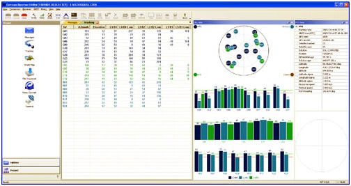
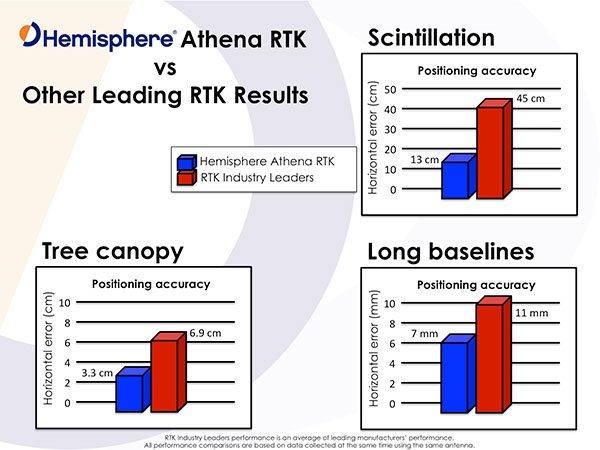
    Athena has yielded outstanding performed in virtually every environment where high-accuracy GNSS receivers can be used, the company stated. Hemisphere customers have tested Athena’s performance in long baseline, in open-sky environments, under heavy canopy, and in geographic locations experiencing significant scintillation.

    Hemisphere has designed its new core engine to maximize the company’s ability to excel at the rigorous GNSS requirements in multiple market segments, supplying its customers in machine control, survey and GIS, with a design for now and in the future, Hemisphere said in a statement.

    The release of Athena is a significant milestone for Hemisphere, which promises another new product entry into the market in the coming months.

    Features of Athena include these capabilities:

    • Initialization time — A reliably consistent initialization performance, less than 15 seconds at better than 99.9 percent reliability.
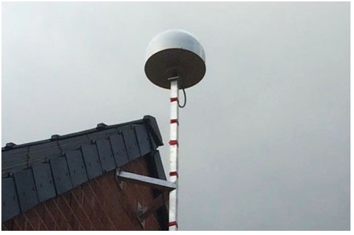
    • Robustness in difficult operating environments — Extremely high productivity under the most aggressive of geographic and landscape oriented environments for GNSS, while delivering up to 50 percent better performance in user tests matched against competitive systems.
    • Performance on long baselines — Position stability for long baseline applications, with position quality often times exceeding the performance of other leading RTK systems on the market.
    • Performance under scintillation — Sustained accuracy under ionospheric scintillation activities, providing one of the most reliable means to work with GNSS in scintillation-affected areas.

    Rodrigo Leandro, Hemisphere’s director of engineering, GNSS Positioning Systems, gave this description of the design process for Athena.

    “Development of Athena started shortly after I came to Hemisphere in August of 2013. The company has been a leader in RTK solutions for many years. During those years, we focused in certain specific market segments such as agriculture, and under new leadership we determined there was a need to address a wider spectrum of market segments, with very high accuracy and feature rich capabilities built on the strong legacy platform we had already established. So, working with Mike Whitehead, the company CTO and our main RTK technologist, we identified the goal of reengineering our RTK engine to match the needs of RTK for the next 10 years, and to provide a foundation for future product development.”

    Leandro continued, “As part of this, we made a decision to build an expanded, world-class software development team, pulling great talent from around the industry to create a group of 11 totally focused on what we should do to move GNSS technologies forward — looking at all types of positioning techniques, not just RTK. Athena is just the first result of that work to become publicly available — you will see plenty more coming from the team over time.

    “Looking at Athena specifically, we did a complete review, touching every part of the engine — from how we deal with the atmosphere, quality-control of the data, modeling the clock of the receiver, and so on, through to how to do external corrections, whether single-based or network-based. We even looked at and modified the receiver system, improving the multitasking architecture to more actively use the CPU for our computational work,” Leandro said.

    I’m proud to say that the results of all that work match up to what we envisioned. RTK is a pretty mature technology at this point, so improving on what is available in the industry is a tough ask. However, our extensive competitive testing shows that the engine performs really well in terms of initialization, accuracy, and stability across a range of different environments, for instance in long baselines and under tree canopy, and our tests of scintillation are showing great results as well. Overall, we have seen excellent accuracy coming out of this engine compared to legacy as well as others in the marketplace. It’s hard to win every single time in a toe-to-toe comparison, as systems and conditions differ in every test, but our broad testing shows us not only matching, but beating competitive systems pretty consistently.”

    Photo: Hemisphere GNSS

    “In our user base, both Hemisphere branded products and our OEM boards, we get exposed to a wide variety of applications and environments, from agriculture and marine, through machine control applications and survey systems,” Leandro said. “Our goal from the start was to build a system that performed across that user base, and we are proud to say that we have delivered with Athena.”

    “In terms of availability, we want to get the Athena engine on as many current and legacy systems as possible, so our users have the best possible experience. However, we have also been improving the legacy engine as well, delivering gradual steps of improvement to our customers, so whatever version they are using, their experience should be much improved,” Leandro concluded.

    Test Reports

    Hemisphere GNSS provided the following statements by an independent tester and from customers, widely distributed around the industry.

    “I’ve had an opportunity to thoroughly test Athena in both moderate and extreme environments,” said Andy Carbognin, an independent GNSS test specialist at Vecto Geomatics of Ottowa, Canada. “I’m very impressed with the performance, and we’ve tested alongside the current industry leaders’ top-of-the-line products. In every situation, Athena is proving to be a tremendous improvement over Hemisphere’s most widespread legacy firmware versions, at a minimum, matching the industry’s best while in many cases exceeding their performance.”

    “Carlson Software has extensively tested Hemisphere’s new Athena RTK engine on the Carlson BRx5 GNSS receiver,” said Butch Herter, director of Hardware Development, Carlson Software. “The Athena RTK engine provides precise, reliable, and repeatable positions. Athena exceeds or matches the performance of all other GNSS receivers it has been tested against. We have been particularly impressed with the performance of the Athena engine, when using a long baseline or in areas where there is a limited view of the sky. Athena is a first class RTK engine.”

    “We’ve been working with Hemisphere’s technology for a number of years,” states Randy Noland, vice president of business development and director of Machine Control, Carlson Software. “I’m amazed at the team they’ve brought together and how they’re radically modernizing their technology. Collaborating with the ‘new’ Hemisphere has been an eye-opening experience, and I’m excited at how their innovative technologies will positively impact our future business.”

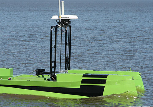
    “In the marine construction and hydrographic survey markets, time is money. We’ve seen very high system reliability and impeccable results using the Athena RTK engine, which ensures we are achieving maximum up-time,” said Harrison Steves, operations manager at Cable Arm. “As well, not being tied to a specific make of RTK base gives us flexibility with our equipment deployment.”

    “We’ve found Athena to offer exceptional performance, especially their RTK fix times and maintaining RTK lock on long baselines,” said David Vaughn, CEO, Novariant. “With the latest competitive performance testing completed, Novariant is excited about adding Hemisphere’s Athena offering to the list of the Novariant-recognized certified receivers that, when combined with our precision steering solution, can assure centimeter-level steering control in the toughest environments in the world.”

    CEO Statement

    “Our goal is to be nothing short of the best GNSS technology partner in the industry, and a key component of that is delivering market-leading technologies tailored to our customer’s needs,” said Chuck Joseph, Hemisphere GNSS CEO and president. “To that end, we have put together a world-class team that is totally rethinking our product family, and our new Athena engine is just the first, powerful proof of our fresh approach. Watch this space!”

    Availability

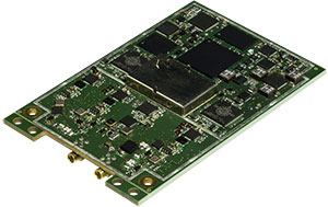
    Before the end of this month, Athena will be included in all Hemisphere multi-frequency, RTK-capable products, such as the A325, R330, S320 and VS330. To download and install Athena, visit Hemisphere’s Software page.

  • Topcon GNSS Network Expands to Latin America

    Topcon GNSS Network Expands to Latin America

    Photo: Topcon GNSS

    Topcon Positioning Group is expanding the TopNETlive GNSS reference station network into Latin America. In conjunction with hosting partners, new service will be provided in Mexico, Peru, the Dominican Republic, Bolivia, Guatemala, Colombia and Panama.

    TopNETlive is designed to deliver high-accuracy GNSS correction data to rovers for surveying, construction, GIS mapping and agricultural applications.

    Partners in the Latin America expansion include TTQ of Monterrey, Geomatic Instruments Corporation, Caribbean Positioning System, Mertind, GYFSA and GeoSystem.

    “The growth of the network into Latin America through these strong partnerships clearly demonstrates the Topcon commitment to grow TopNETlive and provide quality service to more positioning professionals globally,” said Jonathan Ball, senior manager for the Topcon network business. “Our hosting partners provide outstanding support, training and service to their customers and the addition of the TopNETlive reference stations will allow them to expand their operations by offering real-time network correction data.”

    Topcon dealers will host TopNETlive throughout the various regions, which include: TTQ of Monterrey for Mexico, Geomatic Instruments Corporation in the Peruvian market, Caribbean Positioning System in the Dominican Republic area, Mertind Ltda in Bolivia, GYFSA in Guatemala, and Columbia-based GeoSystem will host the network throughout Colombia and Panama.


  • CHC Introduces LT500 Series GNSS Handheld

    CHC Introduces LT500 Series GNSS Handheld

    Photo: CHC

    CHC has launched the LT500 series of handheld GPS receivers. The LT500 series LT500N /LT500T/LT500H covers three accuracy ranges from sub-meter to centimeter accuracy and is a cost-effective full GNSS positioning solution for survey, construction and GIS professionals.

    Powered by the Windows Embedded Handheld 6.5 operating system, the LT500 is accurate, rugged and versatile, CHC said. User productivity is enhanced with the built-in gyroscope, an innovative laser plummet for positioning the accurate handheld receiver over a point, an E-compass for showing the direction and G-sensors for leveling.

    The LT500 series is competitively priced and comes with several bundled software programs, including SurvCE, DigiTerra, MapCloud and other third-party software.

    “CHC’s LT500 series is our brand-new GNSS handheld, which has amazing features and specifications. It meets more customers’ needs with more options and affordable prices,” said George Zhao, CEO of CHC. “The introduction of the LT500 demonstrates CHC’s commitment to provide the GIS community with a full spectrum of rugged, cost-effective professional GPS handhelds.”

    The CHC LT500.
    The CHC LT500.

    The LT500 series features these specifications:

    • 1-GHz high-speed CPU with 512-MB RAM and 16-GB flash memory built-in
    • Three tracking options:
      • LT500H 120 channel GPS L1/L2/L2C,GLONASS G1,G2,BeiDou B1, Galileo E1 Tracking
      • LT500T 220 channel L1,G1,B1
      • LT500N 12 channel L1
    • 13-hour battery: 11.1V, 2600mAh
    • Gyro, laser-plummet, E-compass, G-sensor

    The LT500 series is available immediately through CHC’s worldwide distribution channel.

  • FAA Grants Topcon UAS Exemption for Sirius

    FAA Grants Topcon UAS Exemption for Sirius

    Sirius-Topcon-UAS-O

    Topcon Positioning Systems has received a national exemption from the Federal Aviation Administration (FAA) that allows for operation of its unmanned aerial system (UAS) in the United States. The exemption covers the operation of the Sirius Basic and Sirius Pro for aerial data collection.

    In early April, the FAA issued 30 more commercial exemptions, bringing the total to 99. That number has since grown to 235.

    The Sirius Pro and Sirius Basic systems are designed to produce accurate solutions for the automated mapping of a wide range of sites — regardless of terrain — including construction sites, mines and quarries. The UAS are designed for land surveying, transmission line and pipeline inspection, and agricultural operations such as field mapping and livestock management. With the Sirius Pro model, Topcon eliminates the need for ground-control points by combining real-time kinematic (RTK) GNSS solutions with precision timing technology to provide accurate mapping results, Topcon said.

    “This exemption is exciting news for the U.S. marketplace,” said Eduardo Falcon, executive vice president and general manager of the Topcon GeoPositioning Solutions Group. “It allows Topcon to be a resource for end-users and provide UAS demonstrations and training. Aerial data collection has a strong impending impact on all the industries we serve, and the possibilities for survey, construction, and agricultural applications are seemingly limitless.

    “Building on the success the Sirius models have already seen in the European and Australian markets, this exemption allows Topcon to expand on that momentum in the U.S.,” Falcon said.

  • Trimble Expands Product Line for Surveyors

    Trimble Expands Product Line for Surveyors

    Photo: Trimble

    Trimble has expanded its portfolio of geospatial solutions for surveyors, engineers and mapping professionals. Highlights include new total stations, a new GNSS receiver and new field and office software features. The solutions save time, reduce costs, streamline workflows and produce high-quality geospatial deliverables across a wide range of industries, Trimble said.

    “Trimble’s portfolio expansion will enable our customers to work in a more efficient, seamless and collaborative manner,” said Chris Gibson, vice president of Trimble. “Trimble’s solutions are best known for quality, dependability and performance. Our vision is to equip customers with the most innovative tools, which includes a focus on offering new software applications that streamline and elevate the value of geospatial data to guide smart decision-making and transform the way organizations work.”

    The expanded portfolio of productivity solutions include:

    GNSS Solutions

    The new Trimble R8s Integrated GNSS receiver and updated version of Trimble Access field software combine to offer configurable and scalable settings. Surveyors have the flexibility across their workflows by being able to tailor the Trimble R8s receiver with the updated field software for their specific application. The ability to customize provides flexibility for future business requirements and allows customers to maximize efficiencies across their workflows.

    Total Station Solutions

    Trimble-totalstations-W

    A range of new and enhanced robotic total stations — the Trimble S5, S7 and S9 — improve project efficiencies, productivity and deliverables. Times saving enhancements include improved Trimble VISION technology, SureScan technology included in the S7 and optional in the S9 total station, and the DR Plus electronic distance measurement technology as a standard feature.

    Theft and loss risks are also minimized now with Locate2Protect technology embedded in each instrument, allowing users to remotely track the location of their equipment in real-time using Trimble InSphere Equipment Manager.

    In the office, Trimble Business Center software can be used to create high-dynamic-range (HDR) images using data captured with total stations. A new total station data editor enables fieldwork to be rapidly reviewed and allows surveyors to create deliverables with confidence, Trimble said.

    Scanning Solutions

    Trimble continues to blend powerful 3D laser scanning and imaging hardware with workflow-based software to drive new efficiencies for survey applications and construction planning and design.

    The Trimble TX8 3D laser scanner now offers greater accuracy (down to 1 mm) and streamlined onboard operation when measuring to longer ranges, decreasing the field time required for capturing reliable high-accuracy data.

    Enhanced tools in Trimble RealWorks software version 9.1 further reduce the time to produce high-quality deliverables from Trimble TX8 data. The new version of Trimble RealWorks software includes improved workflows for creating floor settlement plans and 3D pipeline models as well as complete storage tank inspection and reporting capabilities.

    cameraSightImage_S6-W

    Imaging Solutions

    Trimble enhancements to Trimble VISION workflows increase the value of highly accurate image data. Survey, engineering and civil infrastructure professionals can now generate dense point cloud deliverables in Trimble Business Center from images captured using the Trimble V10 Imaging Rover. Users can also quickly generate 2D CAD and 3D real-world models from images captured with Trimble total stations using the streamlined workflows created within Trimble Business Center and SketchUp software.

    Availability

    Trimble Access field software, Trimble Business Center version 3.50 office software, the Trimble R8s GNSS receiver, Trimble S5, S7 and S9 Total Stations and TX8 3D Scanner are available now through Trimble’s Geospatial Distribution Channel.

  • Applanix Unveils Expanded Marine Product Portfolio

    Applanix Unveils Expanded Marine Product Portfolio

    Applanix has introduced an expanded portfolio of marine georeferencing and motion compensation solutions. Taking advantage of Applanix proprietary technology, the new line-up of marine products offers high-performance solutions to a broader cross-section of the hydrographic survey industry.

    All Applanix Marine products benefit from the optimal integration of GNSS and inertial observables, with access to Trimble GNSS technology for performance advantages.

    The Applanix POS MV Surfmaster.
    The Applanix POS MV Surfmaster.

    The announcement was made at Ocean Business 2015, an exhibition of more than 300 of the world’s leading manufacturers and service providers in the industry.

    “Advances in Applanix inertial technology enable us to offer the high performance levels we are known for at even more attractive price points. By introducing this new product portfolio, we are able to deliver solutions suited to all types of bathymetric mapping,” said Peter Stewart, director of Marine Products. “This revised product lineup demonstrates Applanix’ continued commitment to provide customers with options that best fit their budget and requirements.”

    At the entry level of the expanded product portfolio, Applanix introduced the new POS MV SurfMaster. Incorporating Applanix’s proprietary SmartCal inertial calibration techniques, POS MV SurfMaster delivers robust georeferencing for small platforms, both manned and unmanned. SurfMaster is fully supported by Applanix’ post-processing software POSPac MMS, and can deliver roll and pitch accuracy to 0.03 degrees, regardless of latitude or rate of vessel motion.  

    Applanix’ new marine product lineup also includes POS MV WaveMaster II and POS MV OceanMaster. Using newly developed inertial technology, POS MV WaveMaster II delivers performance equal to the well-established and proven WaveMaster E, but at a new lower price point. POS MV OceanMaster replaces the POS MV 320 E as the georeferencing and motion compensation solution of choice for the hydrographic professional, integrating next generation inertial sensors, which enable performance and pricing previously unavailable with this class of technology. POS MV OceanMaster provides reliable and robust surveying in even the most demanding sea conditions. POS MV Elite remains the ultimate option for users seeking the highest level of performance available to the industry.

    The new POS MV SurfMaster, POS MV WaveMaster II and the POS MV OceanMaster are available now worldwide through the Applanix sales channel.

  • Hemisphere GNSS Offers RTK-Capable Compass Antenna

    Hemisphere GNSS Offers RTK-Capable Compass Antenna

    The Hemisphere GNSS V320 GNSS compass.
    The Hemisphere GNSS V320 GNSS compass.

    Hemisphere GNSS is offering a new RTK-enabled Vector V320 GNSS compass. The Vector V320 smart antenna supports multi-frequency GPS, GLONASS, Galileo (future firmware upgrade required) and BeiDou, and Hemisphere GNSS says it’s “the first of its kind.”

    Designed for the professional marine and marine survey markets, the Vector V320 is the a multi-frequency, multi-GNSS, all-in-one smart antenna capable of both RTK-level positioning accuracy and better than 0.2-degree heading accuracy in a simple-to-install package.

    “The Vector V320 combines our expertise in GNSS and smart antenna design,” said Lyle Geck, senior manager, Product Marketing, at Hemisphere GNSS. “With RTK performance that competes with current industry leaders, extremely accurate accelerometer-aided GNSS heading, and the simplicity of install offered by the smart antenna design, it is an incredible product.”

    The Vector V320 is the latest in a line of GPS/GNSS compasses, including the multi-frequency, multi-GNSS Vector VS330 receiver as well as the Vector V102, Vector V103 and Vector V104 compass smart antennas.

    “There has been a void in the market. Our customers have been looking for a product that provides RTK accuracy together with precision heading in an easy-to-install package,” said Andy Smith, managing director of Saderet Ltd. “The Vector V320 delivers.”

    The Vector V320 GNSS compass is being featured by Hemisphere GNSS at Ocean Business in Southampton, UK, April 14-16, at stand K12.

  • ComNav, CGEOS Build First BeiDou CORS Station in Europe

    Experiencing the Qiao Station with ComNav T300 for surveying.
    Experiencing the Qiao Station with ComNav T300 for surveying.

    Europe’s first commercial BeiDou CORS station  — Qiao CORS Station — has been built in Wallonia, Belgium. ComNav partnered with local company CGEOS – Creative Geosensing on the project. ComNav develops and manufactures GNSS OEM boards and receivers for demanding high-precision positioning applications.

    Qiao means bridge in Chinese, and Joël van Cranenbroeck, managing director of CGEOS, is working to build the bridge between the Chinese and European GNSS industries by introducing the Chinese high-precision GNSS technologies of ComNav Technology to European users, ComNav said in a statement.

    The Qiao Station can track BeiDou Navigation Satellite System on the three frequencies and transmit observation data in RTCM format in real time through NTRIP and observation data in RINEX format. It enhances the positioning performance and result by combining BeiDou with GPS and GLONASS.

    Currently, the BeiDou Navigation Satellite System mainly covers  the Asia Pacific region. Though China is still in the process of building it into a global network, up to six BeiDou satellites can now be tracked in Europe during certain periods of the day. With the new Qiao Station, European users can now try the BeiDou system.

  • Septentrio Introduces Next-Generation GNSS Receiver, AsteRX4

    Septentrio Introduces Next-Generation GNSS Receiver, AsteRX4

    Septentrio's AsteRx4 OEM.
    Septentrio’s AsteRx4 OEM.

    Septentrio has launched its next-generation dual-antenna GNSS receiver, the AsteRx 4 OEM. The AsteRx 4 OEM is a multi-frequency, dual antenna receiver that incorporates the latest innovative GNSS tracking and positioning algorithms from Septentrio. It offers users in the marine, machine control and agricultural industries precision, accuracy, reliability and ease of use, the company said.

    Thanks to Septentrio’s positioning engine, which uses advanced multipath and ionosphere modeling algorithms, the AsteRx4 offers robust positioning scalable from meter to centimeter accuracy. Together with precise heading and reliable error estimates, the AsteRx 4 OEM functions in tough conditions on land, at sea or in the air.  

    Use of all available constellations (GPS, GLONASS, BeiDou, Galileo) provide the operator with a reliable solution even in obstructed areas such as in narrow city streets or at the corners of large structures, Septentrio said. The AsteRx4 OEM features the full range of positioning techniques from stand-alone to real-time kinematic (RTK).

    For users who operate in more remote regions of the globe, the AsteRx4 OEM supports Veripos and Terrastar correction PPP services. Furthermore, the receiver features special interference mitigation technology which filters out ambient intentional and unintentional RF interference.

    The AsteRx4 OEM is straightforward to set up and integrate with existing systems, Septentrio said. It has the similar hardware interface as earlier AsteRx receivers, and supports the same open and well documented command and binary output format. Users will be able to operate their receiver without special configuration software by using the very accessible web interface, which is available via network and USB connections.

    “AsteRx4 incorporates many powerful improvements based on practical difficulties our customers face in the field every day,” said Jan Van Hees, vice president of Business Development, Septentrio. “We are particularly proud of the solutions for interference robustness that we have incorporated into our new ASIC,  the GReCo4; the solid and reliable positioning algorithms that result from taking the receivers into the most extreme environments and from focusing not only on accuracy, but on reliability of the position solution.”

    The AsteRx4, along with all the AsteRx family of receivers, will be on display at booth W40 for the duration of Ocean Business 2015 starting April 14 at the National Oceanography Centre, Southampton, UK.

  • FAA Grants 30 More Commercial UAS Exemptions

    FAA Grants 30 More Commercial UAS Exemptions

    The PrecisionHawk UAV.
    The PrecisionHawk UAV.

    The Federal Aviation Administration has approved 30 more commercial unmanned aircraft systems exemptions, bringing the total number of approved operations to 99, reports AUVSI News. AUVSI is the Association for Unmanned Vehicle Systems International.

    Among those receiving exemptions are the insurance companies USAA and AIG. USAA said in a press release that the exemption “could help speed review of insurance claims from its members following natural disasters.” USAA plans to fly the PrecisionHawk drone.

    USAA also filed for an additional FAA exemption in November that will enhance USAA’s ability to use drones in catastrophes. That exemption petition is pending approval, and a decision is expected soon.

    Other companies receiving exemptions include senseFly for precision agriculture, and AeroVironment for agriculture, aerial survey and patrol applications.