Trimble has introduced Trimble TrimView Direct, a mobile application that leverages existing real-time data collected by Trimble’s TrimFleet Suite for the ready-mix concrete industry. Trimble has teamed with development partner, BCMI, to expand on how the data is viewed and used by top-level management.
By leveraging mobile technology, organizations have access to instantaneous information so managers no longer need to wait for paper reports to understand the state of their business. Using TrimView Direct, ready-mix producers and management across the organization have real-time access to critical data that impact their daily business decisions. The app collects information from existing systems and integrates it in a Web-based environment to deliver an accurate view of the company’s strengths, customer trends and opportunities for improvement on a mobile platform.
The app, available on iOS and Android devices, provides a dashboard of real-time data, including order status, ticket details, order timelines, fleet analytics and performance, vehicle location, trip status, signal health, driver hours and performance. The data can be filtered and viewed using maps, graphs, charts and timelines for a visual representation of critical information.
TrimView Direct is organized in modes: delivery, fleet and driver. Navigating using scrolling menus and toggle screens, users can tap or swipe the page to instantly find and record data.
For example, managers use the fleet dashboard to see average cycle miles, current fleet usage, average costs, signal health and delivery performance for a fleet, plant, truck or group of trucks. Sales and account managers who are on a customer site can reference data in the field, including order status, performance, timeline and ticket information.
“Our work with BCMI empowers today’s mobile worker,” said Glenn Bramer, director of marketing for Trimble Construction Logistics. “As we continue to develop solutions that transform the way work is done, we must look at how we can extend valuable information beyond desktop users and enable management to make smarter decisions anytime, anywhere. TrimView Direct is a bold step in this direction.”
“Coupling Trimble’s expertise in collecting real-time data for improved productivity with our movement to modernize the tools and processes for ready mix operations, we have enabled the entire concrete production chain, both human and machine, to interact with actionable, real-time information,” said Bernie Benson, co-founder of BCMI.
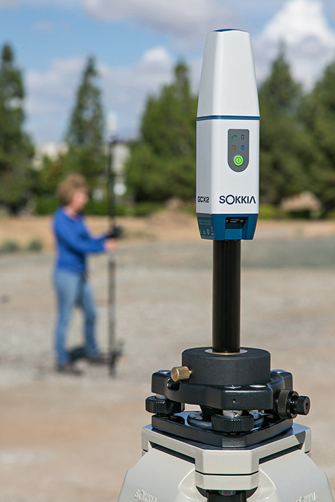
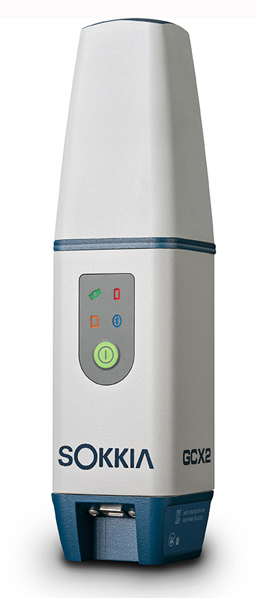
Sokkia has introduced a GNSS integrated receiver designed for lightweight and convenient field operation — the GCX2.
“Nicknamed ‘the bullet’, the GCX2 exemplifies a completely reimagined approach to receiver design that offers an ultra-lightweight and ergonomic solution at a low cost,” said Eduardo Falcon, executive vice president and general manager of the GeoPositioning Solutions Group.
The multi-constellation and dual-frequency receiver is designed to offer affordable high-quality results for traditional applications in the surveying and construction fields — as well as unconventional uses such as in landscape architecture, GIS, BIM and forensic mapping. The receiver connects via Bluetooth to the Sokkia S-10 or GHX2 field controller, enabling ease-of-operation within the MAGNET suite of software. The GXC2 uses 226 channels, each one optimized to constantly track any currently available satellite signals.
“This is the smallest and lightest integrated receiver Sokkia has ever offered,” said Falcon. “The innovative POST (Precision Orbital Satellite Technology) antenna element allows for a form that is both ergonomic and extremely lightweight, which fully differentiates it from existing receivers in the market. The unique ‘bullet’ shape appears as a small extension of the range pole — almost as if it’s not even there.”
The receiver features radio-free RTK operation via interference-free data communication technology, which eliminates licensing issues. When used as a base station, it can support up to three concurrent GCX2 rovers at a range of up to 300 meters. Each receiver can be used as a base or as a rover.
For network operation, the GCX2 may be paired with a cellular-enabled data-controller to provide RTK network corrections and connectivity with MAGNET Enterprise.
“The GCX2 delivers a high level of performance and efficient workflow, and it’s offered with a substantial pricing advantage over competitive systems,” said Falcon.
Additional features include a rechargeable battery and Sokkia receiver utility (SRU) software compatibility.
The United States Civil GPS Service Interface Committee (CGSIC) has issued a notice about a problem some receivers are having implementing the correct time. The U.S. Coast Guard Navigation Center has received reports of synchronization issues since the implementation of a leap second on Jan. 21. Users experiencing this problem should contact the receiver manufacturer for a firmware or software update.
Below is the text of the CGSIC notice:
All CGSIC: 2015 GPS Future Leap Second Implementation
The GPS 50 bit-per-second navigation message transmitted by each GPS satellite (specifically Page 18, subframe 4) includes the parameters needed to relate GPS time to UTC (Coordinated Universal Time). That relationship is maintained through leap second implementation transitions by IS-GPS-200 compliant user equipment. For leap second transition, user equipment must utilize the notice regarding a scheduled future delta time due to leap seconds (ÄtLSF), together with the week number (WNLSF) and the day number (DN), at the end of which the leap second becomes effective.
On or about Jan. 21, 2015, those GPS navigation messages began to include future leap second data which indicates an increase in the leap second to become effective at the end of June 2015. IS-GPS-200 revision H, dated 24 Sep 2013 paragraph 20.3.3.5.2.4 Coordinated Universal Time (UTC), documents the appropriate algorithm details to ensure correct utilization of the parameters above (including all potential truncated week number transitions and variations in time of processing relative to satellite upload timing near the future leap second effectivity).
The data upload for the June 30 leap second, initiated with SVN48/PRN07 at 18:33:56z on Jan. 21, was correctly executed. However, there are several receivers brands/models that seem to be mishandling this information and applying the leap second now. This is creating a negative one-second offset in faulty receivers. The U.S. Coast Guard Navigation Center has reports of these receivers causing synchronization issues with radios, computer systems, and data logging equipment.
Users experiencing issues with GPS receivers that began on Jan. 21 should contact the receiver manufacturer to determine if the latest firmware or software patch can correct the issue.
V/R Rick Hamilton
CGSIC Executive Secretariat GPS Information
Analysis Team Lead USCG Navigation Center
703-313-5930
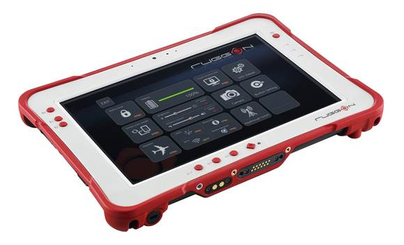
Taiwan-based company RuggON is launching the Rextorm series of rugged tablets. With an ultra-bright 1000 Nit optically bonded display, high speed 802.11ac connectivity, hot swappable dual-battery design, and capacitive glove touch capability, the 10.1-inch fully ruggedized tablets are ready for use in the field.
With the latest communication technology including GNSS Positioning (GPS/GLONASS/Beidou), 802.11 ac, Bluetooth 4.0 and optional 4G LTE, mobile workers can experience precise positioning, fast processing, broad coverage and more stable data transfer even around buildings or trees, RuggON said. For in-vehicle usage, a dual pass-through port allows users to connect via vehicle dock for improved GNSS, WLAN, or WWAN reception. Standard I/O ports include USB 3.0, 2.0, RS232, RJ45, Micro-HDMI, and Micro-SD.
The Rextorm series is a fully ruggedized tablet that meets and exceeds MIL-STD-810G standards for shock and vibration, offers IP65 rating, wide operating temperature range and superior drop resistance of 5 feet on to a concrete surface.
Using the Intel Core i5 Haswell processor, the PX-501 has the fastest processor of the series and is a rugged workstation that can be taken to the field. High-capacity 120GB or 240GB SSDs are available, as well as 4GB or 8GB of DDR3 RAM. A precision digitizer allows accurate input for illustrations and technical work in the field. Windows 7/8 Pro as well as Windows Embedded 7/8 are available.
REAL 2015: Capture, Compute, Create will be held Feb. 25–26 at Fort Mason Center in San Francisco. REAL is designed to explore the professional 3D sensing, creation, and visualization industries. It includes an executive summit and a world’s fair of cutting-edge 3D demonstrations, and is organized by Autodesk.
According to organizers, “From drones to autonomous cars, industrial robots to major engineering works, and game consoles to tomorrow’s mobile phones, 3D sensors are suddenly everywhere. And several decades after first grabbing headlines, VR and 3D printing are hot again, attracting billions in investment, and moving beyond early adopters to professionals. But it is the sum total, where sensing meets making, where big change is brewing.”
Sponsors include Leica Geosystems and Topcon. Two Topcon experts will speak at the event: Jason Hallett, Topcon vice president of global product management, and Eduardo Falcon, executive vice president and general manager of the GeoPositioning Solutions Group.
“The Topcon line of advanced 3D imaging and mapping technologies are designed for a wide range of geospatial applications providing data-rich results,” Falcon said. “REAL 2015 presents opportunities to explore how our mobile and static scanning solutions can be utilized in forward-thinking ways, as 3D sensing and reality capture continue to permeate traditional and non-traditional industries alike.”
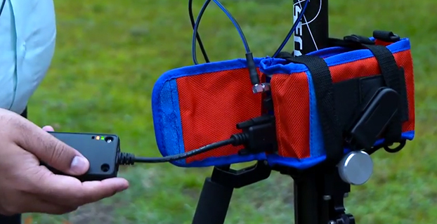
A kickstarter campaign has launched for an NMEA dongle that connects any existing GPS receiver to iOS devices. The device connects and communicates with high-accuracy GPS/GNSS devices and other field sensors that emit NMEA data to iOS devices over Bluetooth, allowing users to collect data on an iPad or iPhone using one or more sensors in the field.
Primary functions include:
overriding the internal GPS on iOS device with the location data coming from the external GPS so all existing apps using internal location services can benefit from the increased accuracy without any changes to the app.
providing the ability to connect with other field sensors that emit NMEA-format data (such as underground cable locators, lasers, resistographs, and audiographs) simultaneously with a GPS so data from multiple sensors can be incorporated into the data-collection application.
Garg explained the need for the dongle on his Kickstarter page: “The accuracy and precision of the internal GPS on iPads and iPhones is highly unreliable — it works fine for navigational purposes but fails miserably for mapping and asset management applications. The accuracy varies in range from a few meters to a few hundred meters depending on operating conditions, and there is no easy way to reliably ascertain that. Tests have proven that the accuracy rating on the location data returned by Apple is more of a general estimate than a reliable metric.”
The NMEA dongle is business-card-sized, and has an internal battery and a long-range Bluetooth. The dongle plusg into an existing GPS receiver’s serial port or connects via bluetooth to transmit the GPS data to the iPad. This allows users to feed RTK/NTRIP data to their iOS device.
“We have tested our solution with most of the leading brands of GPS receivers available in U.S., including Trimble, Topcon, John Deere, Altus, Geneq, EOS, CHC,” developer Sharad Garg told GPS World, “on most of the popular networks that we could get access to, including the Leica, Trimble, MyWayRTK, a few state-run networks and of course Unavco. Our solution is compatible with all of them, so its a very generic product at this point compatible with just about all the different solutions out there.”
Garg said his team also designed the dongle so that it allows users to connect to sensors such as laser range finders, valve exercising machine, Resistographs or agricultural sensors that emit data in NMEA format. The National Marine Electronics Association (NMEA) specification defines the interface between various pieces of marine electronic equipment, a standard that permits marine electronics to send information to computers and to other marine equipment.
“We have actually improved the design very significantly to be very modular and be compatible with all sorts of GPS connections that might be offered by the different vendors out there,” Garg said.
This YouTube video shows the dongle’s RTK functionality.
GPS World published general articles on NMEA and RTK in Innovation:
First of all, on behalf of all of us here at GPS World magazine, allow me to welcome you to 2015. We wish you a healthy and prosperous new year!
I’d like to start out the new year stating the obvious for some of you, maybe most of you…perhaps all of you: GNSS is the new GPS.
In the high-precision GNSS community, I think this is already our mindset, and has been for quite some time. The benefit of using signals from as many satellite navigation systems to the high-precision user is obvious. We saw this with the adoption of GLONASS more than a decade ago. It’s to the point now that even many consumer receivers (such as my Samsung Galaxy S5) utilize both GPS and GLONASS satellites.
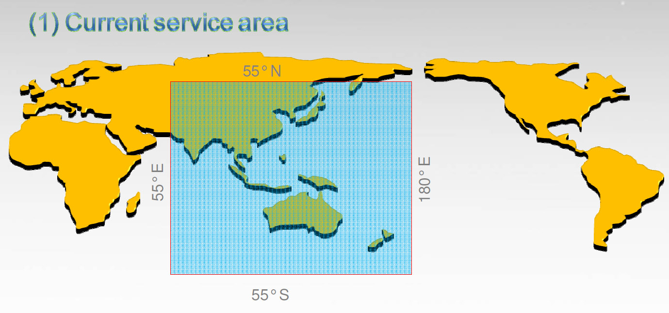
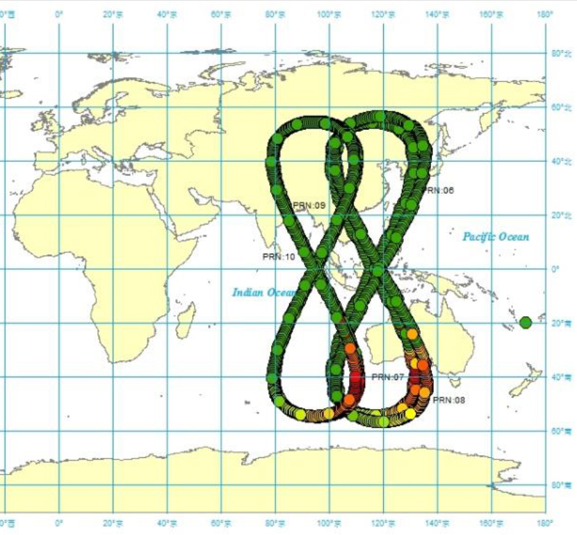
I think it’s pretty obvious we’ll see the same phenomenon with Galileo (Europe) and BDS (China’s BeiDou system). It’s exciting to think about what high-precision GNSS positioning is going to look like just 2-3 years from now. Think about how much better RTK positioning will be with 30+ satellites in view. By the way, that’s already a reality in China where BDS has 14 regional satellites in addition to GPS and GLONASS. It’s the best place in the world for RTK positioning due to the number of satellites in view at any one time, and it might be the reason that China consumes more RTK receivers than the rest of the world combined.
BDS coverage area.
BDS satellite orbit map.
I certainly look forward to the deployment of Galileo and BDS. It will only make us more productive in accomplishing our work. Yet I’m reminded frequently when reading mainstream news headlines that Galileo, BDS, and GLONASS compete with GPS. Even some of those who hold GPS dear to their hearts, such as those who were involved in the development, promotion and deployment of GPS, view the other satellite systems as competition.
Maybe that’s not a bad thing because competitors push each other to perform better. However, where it might hurt is when it comes to support, such as funding. Galileo, in particular, because it’s funded with civil funds instead of defense funds like GPS and GLONASS, has been criticized as a wasteful use of resources because GPS already exists. What more can it add, they ask? The mainstream media doesn’t have a clue that the satellite navigation systems are complementary rather than competitive. You and I know that more satellites generally equates to increased productivity no matter who owns/operates the satellite that is sending the signal. I cringe when I read these headlines:
News Headlines
GPS and its Three Main Competitors: Galileo, Beidou, GLONASS
GPS vs. Galileo; Where Are They Headed?
China Spreads Alternative To U.S. GPS System
China’s Beidou Navigation Satellite System More Precise than GPS in Certain Areas
GPS vs GLONASS: Which Is Best for Tracking Applications?
Generally, I dismiss the mainstream media in the GNSS arena, but these misleading articles can have an impact on funding of the various GNSS, such as Galileo. Politicians and various purse-string holders can be influenced by these stories.
Galileo Moving Forward
The Europeans are pushing forward after the recent hiccup when the first two Full Operation Capability (FOC) Galileo satellites were inserted in the incorrect orbits due to an improper fuel line installation on the rocket launcher resulting in the satellites being inserted in an orbit far below its intended orbit (an elliptical orbit, 49.8 degrees at 26,200 km, vs. the intended circular orbit, 55 degrees at 29,900 km).
In October 2014, shortly after the faulty launch, the outlook for the two satellites was bleak. The consensus was that there was no feasible method to move the satellites to their intended orbits. The good news was that besides the fact that they were in New York instead of Los Angeles :-), they checked out healthy, were properly oriented to the sun, and were “thermally stable.” Would they join GPS SVN-49 in being demoted to permanent test mode status, never being allowed to join the operational constellation, further delaying the deployment of Galileo? Not so.
The first live test was completed on December 9, 2014, when the satellite was one of four Galileo satellites that delivered a position fix of better than two meters. Furthermore, in a January 1 article published on GPS World’s website, Peter Steigenberger and André Hauschild of the German Aerospace Center wrote that the rogue Galileo FOC satellites can likely be used by commercial, multi-frequency, high-precision GNSS receivers for carrier-phase positioning. One drawback is that because the satellite’s orbit doesn’t fall within the limits of the standard Galileo almanac, it may take receivers longer to begin tracking the satellite.
Flight engineers are now working on maneuvering the second rogue Galileo satellite in the same manner, hoping for the same result.
All in all, this is about as good of a result that could possibly be expected. My hat’s off to the folks who made this happen.
Meanwhile, the next four Galileo FOC satellites are moving through the production process. Originally slated for a December launch, I suspect last year’s launch anomaly had the Galileo folks double-triple-quadruple checking, dotting i’s and crossing T’s, so make sure the next launch has the best chance of success. They haven’t announced a new launch schedule yet, but I would guess it’s likely in the next six months, with quarterly launches resuming if things goes smoothly. If all goes well, we could be benefiting from 10 healthy Galileo satellites by the end of the year.
The Hobbico ORA, a new drone system for aerial photographers, is being demonstrated at the 2015 International CES, running January 6-9 in Las Vegas. The camera-equipped drone displays captured aerial images on a seven-inch touchscreen integrated into the transceiver. With a 370-mm diameter and an onboard 1080p HD camera, the ORA also delivers high-quality images, reliability and long range through its recording method and choice of radio frequencies.
Designed for taking aerial views of action sports, outdoor weddings, real estate, vacation vistas and more, the ORA delivers out-of-the-box aerial photo and video capture with no need for radio-control piloting experience. All images are recorded on an SD card built into the drone, providing higher resolution than systems that use the transceiver for data capture, Hobbico said. Use of the 5.8-GHz radio band instead of the typical 2.-4GHz or Wi-Fi ensures a robust connection and a 500-meter flight control and video signal range.
The seven-inch first-person view touchscreen built into the ORA transceiver displays what the UAV’s onboard camera sees in real time, eliminating the need to use a cell phone, tablet or other third-party device to view captured images. Users can frame scenes exactly as they want them filmed by remotely controlling the camera gimbal. One-, two- and three-axis gimbal options are available, each designed also to accept GoPro cameras.
The transceiver has an integrated Android device for programming ORA functions through the touchscreen. A separate OLED telemetry screen displays flight data such as GPS coordinates, altitude and battery power status.
Other highlights include:
30 minutes of flight time per battery charge
Built-in GPS programming that puts flight routes, speed and altitude on auto-pilot
Support for 32 separate GPS waypoints to execute complex flight patterns
The ability to hold a steady altitude and position via GPS to film desired scenes
The option to save coordinates and fly the identical path again any number of times.
Selecting “Return to Home” brings the ORA back to its pilot with a single command. An “Actual Direction” option prevents control reversal confusion during manual flight — when activated, the quad always moves in the same direction as the control sticks. Additional failsafe systems watch for dangers such as low-battery power and automatically bring the ORA and camera home for safe landing.
The Hobbico ORA is scheduled for early 2015 release at an MSRP of $1,500-$2,000 depending on the battery, gimbal and camera configuration. The package will include the drone, 10-channel touchscreen transceiver, gimbal, batteries and charger.
The drone is on display at CES Booth #25214 in the Unmanned Systems Marketplace at the Las Vegas Convention Center’s South Hall 2.
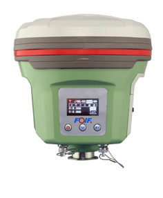
Chinese company FOIF is offering a new survey receiver, the A50. FOIF said that with the A50, the company focused on developing a smart design for a receiver to make it lightweight, yet powerful, making it easy to use for fieldwork. Besides Bluetooth, wireless radio, and mobile network (2G and 3G), Wi-Fi feature was added to broaden data communications for GNSS. The A50 is designed to provide excellent performance, with a high-sensitivity GNSS module.
According to FOIF, the A50 has not only sophisticated onboard software, but also optional application programs such as FOIF FieldGenius and Carlson SurvCE, providing multiple field solutions.
The A50’s features include:
Wi-Fi to achieve quick and long distance parameters settings and data transferring;
Tracking of GPS, GLONASS, Galileo, BeiDou satellites on 220 channels;
An industry-standard GNSS engine (Trimble, NovAtel) that can access local CORS;
horizontal real-time accuracy (rms) of 10mm+1ppm, and vertical of 20mm+1ppm;
OLED display with superior brightness and temperature range
Rugged design, with an IP67 rating;
Voice messaging.
RTK(<30km)
H:8 mm + 1 ppm
V:15 mm + 1 ppm
DGPS
H:0.25 m + 1 ppmV:0.50 m + 1 ppm
SBAS
0.5m (initialization time < 10s, initialization reliability > 99.9%)
Computer security company Absolute Software Corporation is extending its products to use Google Maps to provide improved device geolocation tracking in its Absolute Computrace product. The partnership will provide Absolute customers with improved global coverage and more accurate geolocations.
“The location of a device is an important factor in assessing the risk of a data loss event and measuring compliance with corporate policies. The accuracy of the geolocation data we present in our products is critical to our customers,” said Bill Gordon, vice president, engineering and development at Absolute Software. “Using Google Maps technology allows our customers to track devices and be alerted of risks with the highest accuracy.”
The geolocation capabilities of Absolute Computrace include recent and historical location information for a device, as well as the ability to build geofences to contain devices within a specific geographical area. If a device goes beyond the bounds of a geofence, IT is alerted so they can investigate and determine if the device and the data on it is at risk.
“Our customers rely on our solutions to provide timely and accurate information regarding the health and safety of their endpoints and the data they contain,” said Geoff Haydon, CEO of Absolute Software. “Google Maps will ensure we are delivering the most accurate results, from every device, for all of our customers worldwide.”
Trimble announced today Trimble ProjectSight, a cloud-based solution for construction field management that Trimble says simplifies the creation, access and sharing of project information between the field and the office. The new solution provides mobile workers with access to up-to-date project information and smart workflows for increased productivity and more informed decision making. Trimble ProjectSight allows contractors to lower software costs while enabling a wide team of collaborators to access the information they need.
Trimble ProjectSight is designed for contractors and construction managers who want an easy-to-use and cost-effective field management application. Accessible via a web browser or an iPad app, ProjectSight features a simple, intuitive user interface overlaying smart, project-based workflows to keep teams in sync. Access to centralized data provides users with up-to-date information related to material tracking, issues reporting, information requests and critical project drawings, models and documents. Fully functional offline capabilities allow information to remain available during unconnected sessions commonly encountered on construction sites.
ProjectSight joins other solutions in Trimble’s portfolio for managing construction project logistics, budgets, estimates, schedules, coordination and change in both 2D and 3D datasets. ProjectSight leverages the new Trimble Connect collaboration environment for design, engineering and construction firms. Trimble Connect enables teams to access and manage any data via a cloud platform and specifically allows ProjectSight users to access and share project management data with Trimble Connect users across the design-build-operate lifecycle.
“Effective project management is critical to the profitability of any construction project,” said Mark Sawyer, general manager of the General Contractor / Construction Manager Division of Trimble Buildings. “With Trimble ProjectSight, we now offer a solution that addresses the core functions of project management in a very easy-to-learn, easy-to-use and easy-to-deploy system. ProjectSight ensures workers have access to accurate, up-to-date information and it puts that information in the hands of highly distributed teams at very low cost.”
Eos Positioning Systems has introduced a new line of high-accuracy GNSS receivers for smartphones and tablet computers, including both sub-meter and RTK performance for all mobile platforms: iOS, Android, and Windows.
Eos’s entry-level product, the Arrow Lite, is Bluetooth compatible with all mobile devices.
The Arrow 100 is Eos’s advanced real-time, sub-meter GNSS receiver that utilizes both GPS and GLONASS, and is expandable to Galileo, Beidou and QZSS. It offers superior tracking under tree canopy, around buildings and in rugged terrain, the company said. In addition to supporting SBAS in North/Central America, Europe, Northern Africa, Japan, India and Russia, the Arrow 100 also supports OmniSTAR’s worldwide, real-time sub-meter service.
The most advanced Arrow receiver is the Arrow 200, a dual-frequency, multi-constellation RTK GNSS receiver capable of 1-cm accuracy in real time. The Arrow 200 is an iOS-compatible RTK and OmniSTAR receiver that works with all models of iPads and iPhones via wireless Bluetooth connection. An iOS NTRIP app that allows the user to log into any available RTK network. The Arrow 200 will provide quality RTK performance for years to come because it supports current and future satellite constellations: GPS, GLONASS, Galileo, BeiDou and QZSS, the company said. It also supports OmniSTAR’s G2, XP and HP real-time worldwide decimeter services.
“After spending more than 12 years designing high-accuracy Bluetooth GNSS receivers, I believe Eos has set the new standard for high- accuracy GNSS receivers that work across all mobile platforms, no matter if it’s iOS, Android or Windows,” said Chief Technology Officer Jean-Yves Lauture.
All Arrow receivers employ long-range (1-km) universal Bluetooth connectivity so the user can interface to any brand of smartphone or tablet, whether it’s iOS, Android, or Windows-based. A variable-power Bluetooth implementation allows the Arrow receivers to communicate up to one kilometer from the mobile device.
Arrow receivers have been optimized to run all day on battery power. The battery pack is field-replaceable and rechargeable separately. It contains smart charging logic so expensive battery chargers are not needed.
All Arrow receivers have been designed to meet IP-67 specifications for immersion in water and are completely dust-proof so they will survive in the harshest environments.
The Arrow receiver product line is targeted at high-accuracy applications like GIS, environmental, agriculture, electric/gas/water utilities, surveying, machine control, and federal/state/local government.