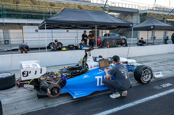
TUM competed in a field of nine teams from 21 universities to win the $1 million grand prize.
Rules of the IAC competition required each team to compete in a fastest-lap competition that included an obstacle avoidance component. The winning team recorded the fastest two-lap average speed of 135.944 mph on the famed oval track.
“Participating in the Indy Autonomous Challenge allowed our team to advance autonomous driving technologies, and being able to take first place after two years of hard work acknowledges that we had an outstanding team,” said Alex Wischnewski, team leader of TUM Autonomous Motorsport. “Our next goal is to win a high-speed autonomous head-to-head race.”
Organized by Energy Systems Network and the Indianapolis Motor Speedway, the primary goal of the IAC is to advance technology that can speed the commercialization of fully autonomous vehicles and deployments of advanced driver-assistance systems (ADAS).
These enhancements will lead to increased safety and performance in motorsports, as well as all modes of commercial transportation. The competition also serves as a platform for students to excel in science, technology, engineering and math (STEM) and inspire the next generation of innovators.
In addition to thousands of attendees at the IMS, and more than 20,000 viewers on the AWS livestream, the IAC hosted 350 high school STEM students representing more than 50 urban, rural and suburban school districts across Indiana.
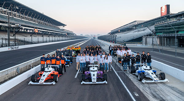
Autonomous racecar competition takes place at the Indianapolis Motor Speedway
The Indy Autonomous Challenge will be livestreamed on Oct. 23 through Amazon Web Services for viewers worldwide. Teams from 21 universities from nine countries will compete for the $1 million grand prize, which will be used to advance the education and research missions of the winning universities.
Livestreaming begins at 1 p.m. EDT and can be viewed on the IAC website homepage and on Twitch @IndyAChallenge.
“Due to the generous support of Amazon Web Services (AWS), we will have a global audience for the first autonomous high-speed competition at the Racing Capital of the World — the Indianapolis Motor Speedway,” said Paul Mitchell, president and CEO, Energy Systems Network, co-organizer of the IAC. “This is critically important as the IAC is a global competition having involved at its inception 41 universities from around the world.”
Organized by Energy Systems Network and the Indianapolis Motor Speedway, the primary goal of the IAC is to advance technologies that can speed the commercialization of fully autonomous vehicles and deployments of advanced driver-assistance systems (ADAS). These enhancements will lead to increased safety and performance in motorsports as well as all modes of transportation.
In addition, the competition is a platform for students to excel in science, technology, engineering and math (STEM) and inspire the next generation of innovators.
Brandmotion LLC is collaborating with DENSO Products and Services Americas to offer a one-stop service to cities seeking to equip vehicles with advanced vehicle-to-everything (V2X) technology.
DENSO is a global mobility supplier and Brandmotion develops vehicle integration for V2X deployments. By combining forces, the two companies are offering cities and agencies an easier path to vehicle integration for V2X deployment testing.
V2X technology has been proposed by the U.S. Department of Transportation as the best way to address the chronic death toll on America’s roadways, with nearly 37,000 lives lost and a record 6,721 pedestrians killed at intersections in 2020. Many city managers and state transportation agencies are looking to deploy V2X technology regionally to reduce vehicle crashes and fatalities and improve pedestrian safety.
The DENSO-Brandmotion partnership simplifies the process of equipping vehicles for long-term testing. Many cities have had to assemble the elements of a large vehicle V2X deployment manually, developing specifications and coordinating multiple vendors.
Brandmotion has served the Tampa Connected Vehicle Pilot for five years and provided responsive professional-grade automotive integration and service capability. DENSO is the on-board unit (OBU) supplier to OEMs for phase 4 of Tampa’s pilot project, bringing true Tier 1 development capabilities to the project.
The partnership will provide transportation agencies with the following vehicle-related deployment services:
the DENSO On Board Unit (OBU) platform (Hercules), which has the ability to run and process applications that support both cellular V2X (C-V2X) communications and dedicated short range communications (DSRC) in an automotive environment (while DSRC is still permitted by the U.S. Federal Communication Commission)
a standard set of applications, including blindspot/lane-change warning, electronic emergency brake light, forward crash warning, intersection movement assist, red light violation warning, and traffic signal priority
custom application development for specific agency application goals
thorough vehicle-specific installation planning, vehicle system design and validation
small to large-scale installation and tech support.
TomTom integrates Vaisala’s environmental data capabilities into its Hazard Warnings service to deliver time-critical alerts for road weather hazards
Vaisala — a global leader in weather, environmental and industrial measurement — will bring its accurate insights and actionable road weather data to the TomTom Hazard Warnings service.
TomTom Hazard Warnings creates time-critical signals that alert drivers and automated vehicles to safety-critical incidents as they happen. These incidents include traffic, weather and road hazards.
“More than every fifth traffic accident is a result of inclement weather-related impacts, yet drivers often don’t receive real-time information about weather or driving conditions from their in-vehicle technology — even in new vehicle models,” said Petri Marjava, head of Automotive at Vaisala. “While TomTom has utilized our atmospheric weather data for years, our new arrangement equips its Hazard Warnings service with must-have predictive road weather information. Road weather data takes in-vehicle weather services to the next level by helping drivers stay safe while conveniently optimizing route and travel times in all weather conditions.”
TomTom Hazard Warnings uses Vaisala’s data to deliver early warnings related to weather hazards, such as slippery roads, reduced visibility and strong winds. This data enables better route planning and notifies drivers to prepare and adjust for driving in poor conditions.
In addition to general weather conditions and detailed point forecasts, Vaisala is now providing TomTom Hazard Warnings with road surface measurements and driving conditions forecasts.
The road weather data Vaisala delivers covers continent-wide road networks across the United States and Europe to enhance driver safety, efficiency and convenience, with other geographical regions to follow.
The Automotive News PACEpilot award recognizes post-pilot, pre-commercial innovations in the automotive and future mobility space. These represent product, software/IT system or process and idea incubators that have the potential to revolutionize an automaker’s business.
This was the second year Automotive News recognized PACEpilot honorees and the first time the publication named Innovations to Watch. Swift’s precise positioning platform was selected as one of 10 winners from a group of 23 finalists from 20 companies.
Swift’s precise positioning solution consists of the receiver-agnostic Starling positioning engine and cloud-based corrections from Skylark precise positioning service. The system was designed for autonomy and built to scale for automotive, to change how automakers and OEMs navigate by reducing costs, improving product flexibility, improving safety and delivering high-fidelity, lane-level absolute positioning.
Swift’s technology has been developed into a precise positioning platform that can improve vehicle GNSS-based positioning from an average of 3 meters of accuracy to better than 4 centimeters. Swift’s solution is a software-only implementation with minimal impact to hardware on the vehicle. The accuracy can be guaranteed down to less than one failure per 1,142 years of driving, making it a highly reliable ADAS and automated driving sensor.
“The team at Swift is honored to receive this recognition from Automotive News,” said Joel Gibson, executive vice president of Automotive at Swift Navigation. “Swift is bringing its ground-breaking, high-accuracy localization to the automotive space and we appreciate that those in the industry are taking notice.”
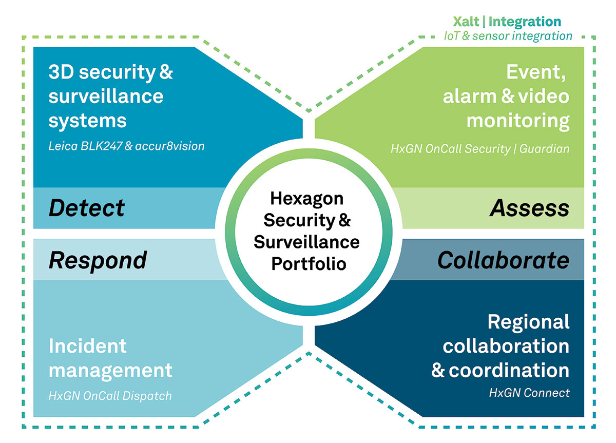
The Security & Surveillance portfolio for rail. (Image: Hexagon)
Hexagon’s Safety, Infrastructure & Geospatial division, in partnership with Hexagon’s Geosystems division, has introduced Hexagon’s Security & Surveillance portfolio for rail.
Comprised of an integrated set of solutions proven in rail operations around the globe, the portfolio unites 3D surveillance systems with best-in-class security, dispatching and collaboration software. It enables rail operators to better protect their assets, passengers and freight to reduce disruptions and improve safety and customer satisfaction.
The portfolio addresses the complete lifecycle of incident management, empowering operators to detect, assess and respond to threats and incidents and collaborate with outside organizations when needed. It includes:
Detect: Leica BLK247 and accur8vision 3D security and surveillance systems go beyond traditional 2D security cameras by integrating lidar, thermal sensors, video and 3D planning and tracking software for high-value areas, perimeters and zones, such as tunnels and rolling stock.
Assess: HxGN OnCall Security | Guardian provides a common operational picture for alarms, sensors, the internet of things, intrusion devices and video data to deliver situational awareness for real-time event monitoring.
Respond: HxGN OnCall Dispatch, a computer-aided dispatch solution with embedded assistive artificial intelligence, allows control room operators to dispatch resources to respond to incidents.
Collaborate: HxGN Connect facilitates collaboration and information sharing between internal teams and external entities to ensure stakeholders are informed and engaged during events.
“Globally, passenger and freight traffic are expected to double by 2050, which means rail operators must begin investing in safer rail operations now,” said Juergen Dold, President, GSI, Hexagon. “Rail networks have a broad spectrum of security needs, and Hexagon’s Security & Surveillance portfolio uniquely spans different hazards, capabilities and teams. It offers scalable solutions that seamlessly transition from simple security monitoring to emergency response to collaboration among diverse teams during complex operations.”
Hexagon’s Security & Surveillance portfolio builds on Hexagon’s capabilities for rail safety and security operations. Every year, Hexagon solutions protect more than 5 billion rail and transit passengers around the world. In North America alone, the company’s technologies help protect more than 56,000 miles of railways.
A roundup of recent products in the GNSS and inertial positioning industry from the September 2021 issue of GPS World magazine.
OEM
Network Expansion
Provides precision timing over fiber
Photo: Huber+Suhner
Direct GPS-over-Fiber is a copper-free GNSS remote antenna that eliminates the need for costly power infrastructure. It uses power-over-fiber technology to distribute both the timing signal and power for the remote device. It is designed for telecommunication and data-center customers in need of scalable timing infrastructure solutions for outdoor remote antenna applications. It is fast and easy to install, with flexible, space-saving configurations that eliminate the need for power infrastructure at the remote end. The product makes network expansion achievable with a compact design and integrated transmitters, eliminating the need for multiple GPS antennas and maximizing the available space. It also extends the signal range between the antenna and the receiver.
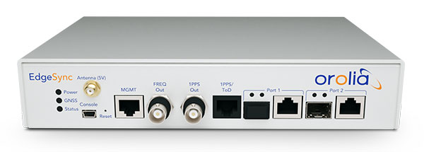
The cost-effective EdgeSync network timing platform provides NTP and PTP grandmaster and boundary clock functionality for real-time edge applications. High performance, scalability, ease of use and manageability make EdgeSync suitable for data centers, finance, mobile edge computing, enterprise, smart grid, industrial IoT, process control and telecommunications. EdgeSync uses a multi-GNSS receiver (GPS, Galileo, GLONASS, BeiDou and QZSS), PTP and Synchronous Ethernet as input references and generates PTP, SyncE, NTP and timing signals (10 MHz, 1 PPS and Time of Day message) as outputs. It also can provide IEEE 1588-2008 (PTP) grandmaster and boundary clock functionality and leverages unique PTP algorithms to deliver stringent timing for demanding, precise applications.
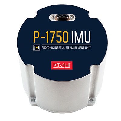
The P-1750 IMU and the P-1725 IMU complement the previously released P-1775 IMU to create a full line of IMUs with high-performance accelerometers and photonic integrated chip (PIC) technology. The P-series IMUs are offered in the same compact IMU housing design, and now offer more dynamic and accurate sensor performance, delivering improved navigation capability and more environmental robustness in vibration and shock capability for more challenging applications. PIC technology features an integrated planar optical chip that replaces individual fiber-optic components to simplify production and increase reliability. The accelerometers used in the P-series IMUs offer greater sensitivity and accuracy in their dynamic ranges. The IMUs are designed for challenging applications on land, sea and air, including autonomous trucks and people movers, drones, autonomous underwater vehicles and platform stabilization. Industries include transportation, military, agriculture, construction and mining.
The HC860 and HC860E active GNSS/Iridium antennas are designed for precise positioning, covering the GPS/QZSS-L1/L2, GLONASS-G1/G2, Galileo-E1 and BeiDou-B1 bands, including regional SBAS. The antennas also support active Iridium reception in the 1616.0-1626.5 MHz band. The HC860 housed and HC860E embedded helical antennas are designed for high-accuracy positioning. They are packaged in a light, compact form factor suitable for a variety of applications, including autonomous vehicle navigation (land, sea and air), handheld survey devices, automotive positioning, timing and other precise-positioning applications.
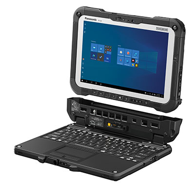
The Panasonic Toughbook G2 is a fully rugged 2-in-1 detachable tablet with optional keyboard that features an innovative modular design and user-removable expansion packs (xPAKs). With three modular expansion areas and up to 36 xPAK combinations, users can customize the Toughbook G2 to suit their needs with options including a 4G LTE-A multi-carrier with GPS or a dedicated U-blox NEO M8N receiver. The device is backward compatible with most Toughbook 20 and G1 docks. It has a 10.1-inch display, an Intel Core i5 and i7 vPro processor and runs on Windows 10 Pro. It has an 18.5-hour battery life. The 2-in-1 detachable design allows users to operate the device both in laptop and tablet modes.
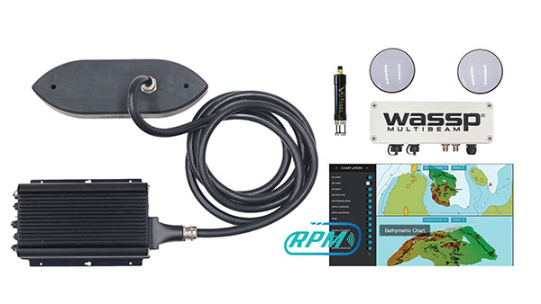
The WASSP S3r multibeam sounder combines data from a multibeam sounder transducer with 224 beams covering a 120° swath port to starboard along with position, heading and motion to create an accurate survey situations and environmental conditions. WASSP S3r is able to survey areas up to 10 times faster than a single-beam sounder. The S3r uses an SBG Ellipse-D Inertial Navigation System for its RTK + INS. The Ellipse-D allows the sounder to create accurately positioned 3D bathymetric representations of the seafloor, down to centimeter accuracy with minimal passes. WASSP has also incorporated the Ellipse-D into its S3Pr portable survey package. The SBG Ellipse-D was able to fit into a covered housing that allows quick setup on small vessels and interface with the WASSP DRX processing unit and CDX software. Ellipse-D integrates a dual-antenna, multi-band GNSS receiver, and is capable of delivering precise heading as well as centimeter-level position accuracy in challenging GNSS conditions.
Voyage is a plug-and-play lidar perception system that delivers highly accurate object detection, tracking and classification capabilities. The deployment kit is equipped with SENSR2 software, lidar sensors and a lidar processing unit. Voyage provides volumetric profiling and motion-prediction capabilities, regardless of lighting conditions, and can collect and process data from up to four sensors for insights across the sensor coverage zones. Voyage does not capture, show or store any biometric and otherwise identifying data to maximize the protection of people’s privacy when installed as part of smart-city and security systems. The company’s sensor-agnostic perception software is available worldwide and is deployed by top-tier organizations such as BMW, Mercedes-Benz, the Chattanooga Department of Transportation and Emart, among others.
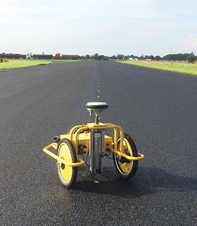
The TinySurveyor is a high-precision instrument for the surveying and infrastructure industries, able to execute large tasks up to 10 times faster than traditional methods. The machine pairs with a GNSS receiver to accomplish large-scale stake-outs, road pre-marking, as-built surveys and topographic surveys. Its ability to mark out existing data or collect new data at high speed and with high accuracy makes the TinySurveyor suitable for repetitive, time-consuming and labor-intensive tasks. With a GNSS receiver, repeatable results ensure accuracy of 1-2 cm. The TinySurveyor integrates with any GNSS receiver and has been tested with units from Topcon, Trimble and Leica.
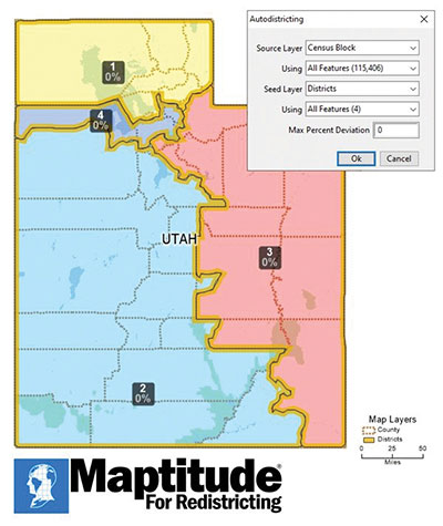
Maptitude for Redistricting 2021 is a specialized tool for political redistricting that enables state legislatures, political and public interest groups, local governments and private citizens to create and advocate redistricting plans that meet their goals, adhere to legal requirements, and stand up to public scrutiny and legal challenges. Unlike a general-purpose GIS, Maptitude for Redistricting streamlines the plan creation process for all types of political boundary definitions and provides all of the calculations and reports needed. It is suitable for congressional redistricting as well as state legislative districts, city councils and local school board districts.
With the Luciad 2021 platform, defense, aviation, maritime and other organizations can develop effective and reliable web applications. LuciadFusion, an all-in-one server solution for geospatial data management, has two new types of data streaming, resulting in faster streaming of imagery and point cloud data. LuciadRIA supports Web Assembly to bring desktop-like calculations to the browser. Luciad 2021 also features enhancements to software development kits for desktop and on-board vehicle applications. LuciadLightspeed seamlessly integrates into JavaFX-based applications, making it easier to embed its map components into user interfaces, and now provides for high-resolution map printing. LuciadCPillar, an API for C++ and C# developers, was updated with labeling support and other new features.
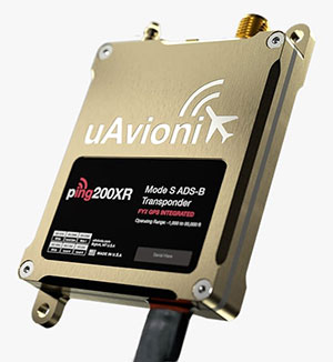
The Ping200XR integrates the capability of the Ping200X TSO Certified Mode S ADS-B OUT transponder with the high-integrity truFYX TSO-certified GPS position source into a single enclosure. The integration simplifies installation and allows the customer to choose between the installed GPS antenna or one provided with the Ping200XR. The integrated GPS ensures maximum safety by providing Source Integrity Level (SIL) 3 RTCA DO-229D and TSO-C145e Class Beta 1 performance, a requirement for Mode S and ADS-B airspace access, and for reception and processing by certified avionics and traffic collision avoidance systems in other aircraft as well as air traffic control. SIL 3 performance is not available from non-aviation certified GPS receivers, which often are used as an autopilot navigation source.
The RTL-450 lidar sensor incorporates a lightweight MEMS mirror and a precision navigation system to generate accurate data for demanding aerial surveying missions. The high-resolution, three-dimensional point clouds it creates enables operators to conduct advanced analytics of geographic and manmade features. Made in the United States, the RTL-450 incorporates patented lidar sensor technology. It weighs just over 4 pounds and is designed to operate independently of a drone platform, providing great flexibility for drone integration. Its modular design facilitates quick, efficient integration onto user-selected platforms.
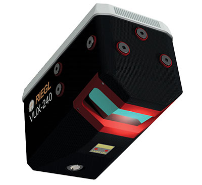
The RIEGL VUX-240 is a lightweight airborne laser scanner, especially designed for use on UAS/UAV/RPAS and small manned airplanes or helicopters. With its wide field of view of 75° and a data acquisition rate of up to 1.8 MHz, the instrument is suitable for high-point-density corridor mapping applications. The VUX-240 uses Riegl’s Waveform-Lidar technology, allowing echo digitization and online waveform processing. Multi-target resolution is the basis for penetrating even dense foliage. A continuously rotating polygon mirror wheel enables scan speeds of up to 400 lines per second, for efficiently covering large areas when operated from fast UAVs or aircrafts. The scanner stores 1 terabyte of data internally and is equipped with interfaces for an external IMU/GNSS system to control up to four external cameras.
The Carrier H6 Hybrid is a heavy-lift gas-electric hybrid drone powered by either the H2400 (Carrier H6 HE+) or H5000 (Carrier H6 HL) hybrid drone generator. The Carrier H6 Hybrid HE+ is equipped with the H2400 generator providing 2400W of continuous power. The recommended payload is 4 kg allowing for up to 2.5 hours of flight. The maximum payload of 6 kg allows up to 1.5 hours of flight. The Carrier H6 Hybrid HL has a maximum payload capacity of 15 kg and can be configured to carry more robust scientific-grade sensors, such as multispectral cameras, professional DSLRs for cinematography and lidar. The H6 Hybrid HL also can be used in heavy-lift applications involving asset transportation and delivery, agricultural spraying and search and rescue.
Harris Aerial, harrisaerial.com
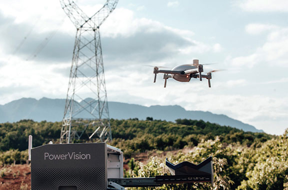
Industrial drone system
Autonomous ops from a dock
Photo: PowerVision
The PowerVision True Unmanned Aerial System combines the PowerEgg X 8K drone, PowerEgg Dock and the PowerVision Cloud web-based software platform. The integration provides a turnkey solution for remote, autonomous data-collection missions. With the system, drones can be deployed at scale as data-acquisition infrastructure, instead of tools to be operated on individual missions. Powered by artificial intelligence, the system streamlines the drone’s takeoff, flight, dynamic mission and return to the charging dock autonomously. The system weighs 34.8 pounds (15.8 kg) in a 570 x 400 x 250-millimeter form factor, allowing it to be deployed by a single person without special tools or equipment. The solution can be used for powerline inspections, environmental compliance, asset inspection, facility security, GIS, surveying and mapping.
The StarCourse service provides real-time extended ephemeris data for GNSS chipsets in connected mobile devices, giving them a headstart in determining position accurately and quickly. For devices with limited connectivity, typical extended ephemeris solutions have provided a headstart with 7¬–14 days of ephemeris data. StarCourse provides a 50% reduction in RAM requirements, 90% reduction in CPU cycles, and high location accuracy. Full data customization is provided to StarCourse subscribers, allowing them to create optimal solutions for their needs. The service enables autonomous positioning on connected GNSS IoT devices including asset tracking, wearables, in-dash navigation and mobile devices. For situations where accuracy is paramount, StarCourse Premium provides ultra-precise predicted ephemeris for the first 24 hours.
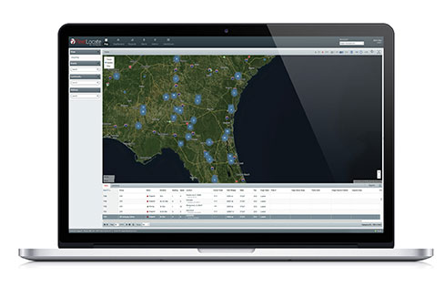
Trailer management solution FleetLocate captures data at the trailer level and translates it into actionable business intelligence to increase trailer productivity while reducing waste and costs. Telematics devices deliver core trailer insights that help automate yard checks and maximize use. Advanced trailer technologies are available, such as solar power management, tethered/untethered configurations, IntelliScan cargo sensing, cargo image capture and retrieval, door sensors, liftgate battery monitoring and more.
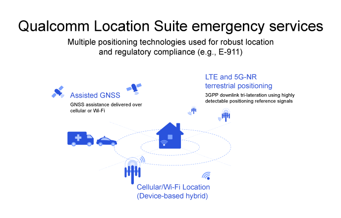
To comply with Federal Communications Commission (FCC) E-911 regulations, Qualcomm Technologies has enhanced its Qualcomm Location Suite to provide improved horizontal and vertical positioning information. The upgrade will help first responders better determine the floor within a multi-story building from which an emergency call was placed.
The Qualcomm Location Suite is deeply integrated with Qualcomm’s Snapdragon Mobile Platforms and Snapdragon Modem-RF Systems that power millions of mobile devices in the U.S. The suite has supported emergency location services in the U.S. and globally for two decades.
The change will help mobile service providers comply with new E-911 regulations requiring that the horizontal and vertical position of each wireless caller be determined with a certain level of precision.
The Qualcomm Location Suite uses GNSS with network-based positioning and dead reckoning to deliver accurate location with speed and efficiency. GNSS assistance is delivered over cellular or Wi-Fi, LTE and 5G-NR terrestrial positioning; cellular/Wi-Fi-based location is also provided.
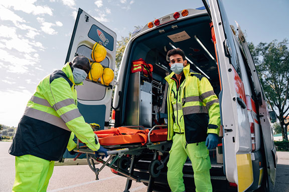
When an emergency call comes in, operators rely on a combination of triangulation of wireless signals and device positioning technologies, such as GPS, to provide the position of the caller. The use of technologies in the Qualcomm Location Suite is designed to result in highly accurate positioning information and the ability to share this reliable information with first responders, allowing them to reach the precise emergency site more quickly.
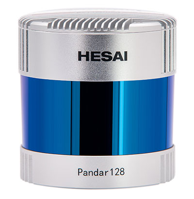
Under a new agreement, Lidar USA — a developer of geomatics solutions — will include Hesai Technology Co. Ltd., 3D lidar sensors in its product lineup. Hesai Technology announced the agreement at the Commercial UAV Expo 2021 in Las Vegas, Sept. 7-9.
The Pandar128 lidar unit. (Photo: Hesai)
Under the terms of the agreement, Lidar USA will leverage its marketing and sales expertise to distribute Hesai sensors across the United States, Canada and Mexico.
“Hesai’s product portfolio has the sensors we have all long awaited — bridging the gap between sensors made for automotive navigation and those made for precision measurement,” said Lidar USA CEO Jeff Fagerman. “Users will enjoy the affordability of the former and results of the latter.”
Hesai’s lidar units offer superior performance and reliability to ensure robust detection under different operating and environmental conditions, the company stated in a press release. Hesai’s XT sensors, embedded with proprietary lidar application-specific integrated circuits (ASICs), deliver performance advantages while maintaining a compact form factor and low cost.
The XT sensors are lightweight and draw less power, enabling longer operation for airborne applications. The XT’s precision and accuracy allows for fine detail capture.
PandarQT, a short-range sensor for blindspot detection, has a large vertical field-of-view of 104.2°. The Pandar series lidars — Pandar128, Pandar64 and Pandar40P — deliver long detection range, high resolution and high point density for optimized perception results.
“Lidars are increasingly being adopted for different end markets and applications,” said David Li, Hesai’s CEO. “We’re excited to partner with an industry leader like Lidar USA, whose strong foothold in North America will help expand access to sensors across different segments.”
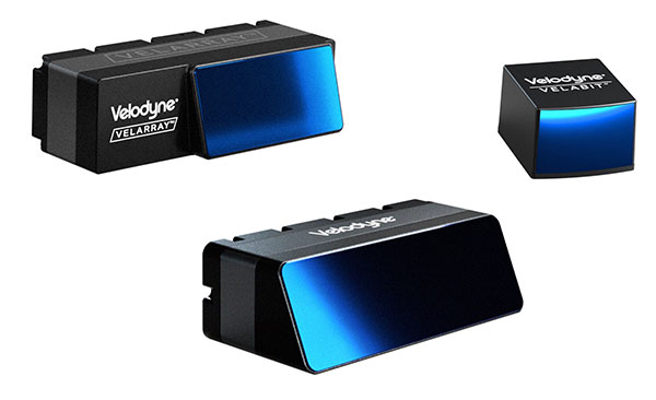
Velodyne Lidar will display its lidar sensors and software at the IAA Mobility trade show, which takes place Sep. 7-12 in Munich.
Showcased are:
Velarray H800, a solid-state lidar sensor architected for automotive grade performance. With combined long-range perception and a broad field of view, the sensor is designed for safe navigation and collision avoidance in ADAS and autonomous mobility applications.
Velarray M1600, a solid-state lidar sensor designed to serve mobile robotic applications, enables touchless mobile and last-mile delivery robots to operate autonomously and safely, without human intervention.
Velabit, Velodyne’s smallest sensor, designed for versatility and affordability to 3D lidar perception.
Velodyne Lidar’s Intelligent Infrastructure Solution addresses the pressing need for smart city systems that can help improve road safety and prevent traffic accidents. The solution creates a real-time 3D map of roads and intersections, providing precise traffic monitoring and analytics that is not possible with other types of sensors like cameras or radar.
Partners Using Velodyne
NI, developer of automated test and automated measurement systems, is co-exhibiting at the Velodyne booth. NI is showing simulations optimized for Velodyne’s lidar sensors that can be used in developing and testing advanced driver assistance systems (ADAS) and autonomous vehicle (AV) capabilities.
NI will demonstrate how its monoDrive AV simulation software is using Velodyne’s lidar technology to create digital twins and is providing validated physics-based sensor models for Velodyne lidar sensors.
Seoul Robotics, an Automated with Velodyne partner, is demonstrating at the Velodyne booth its AI perception engine for Velodyne’s lidar sensors. The engine provides real-time object detection, classification, tracking and prediction for autonomous systems.
The AI engine can power self-driving cars as well as smart-city applications and advanced parameter monitoring systems for facilities. Seoul Robotics’ SENSR perception software includes an AI engine that is fully optimized to utilize Velodyne’s portfolio of lidar sensors, including the Puck, Ultra Puck and Alpha Prime.
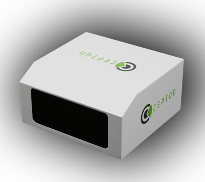
Cepton, a provider of automotive lidar solutions, will showcase its automotive-grade, long-range Vista-X90 lidar device at two upcoming tradeshows in Europe: IAA Mobility 2021 in Munich, Germany (September 7-12) and AutoSens in Brussels, Belgium (September 15t-16).
Photo: Ception
Vista-X90 combines high performance, auto-grade reliability and low cost to meet the critical requirements for mass-market automotive applications. During both events, Cepton representatives will be available to talk about Cepton’s lidar offering for a range of smart mobility applications, including advanced driver assistance systems (ADAS), autonomous vehicles (AV) and smart infrastructure.
With a compact and embeddable design, Vista-X90 is optimized for ease of vehicle integration, offering multiple placement options, such as in the headlamp, in the fascia, behind the windshield, or on the roof. Featuring Cepton’s next-generation ASIC technology, the Vista-X90 supports AUTOSAR and over-the-air (OTA) functionality, with advanced capabilities for functional safety, cybersecurity, and extrinsic calibration.
Visitors to the Cepton booth at IAA and AutoSens will also be able to learn about Cepton’s award-winning lidar solutions portfolio that extends beyond automotive and supports smart infrastructure applications such as smart roads and rail, electronic tolling, and more.
Cepton provides intelligent, lidar-based solutions for a range of markets such as automotive (ADAS/AV), smart cities, smart spaces, and smart industrial applications. Cepton’s patented MMT-based lidar technology enables reliable, scalable and cost-effective solutions that deliver long-range, high-resolution 3D perception for smart applications.
Founded in 2016 and led by industry veterans with more than two decades of collective experience across a wide range of advanced lidar and imaging technologies, Cepton is focused on the mass market commercialization of high performance, high quality lidar solutions. Cepton is headquartered in San Jose, California, USA, with a presence in North America, Germany, Japan, India, and China, to serve a fast-growing global customer base.
Volvo Group Venture Capital AB has announced a new investment in a company in the field of measurable safety for driver assistance and autonomous vehicles. Foretellix Ltd was founded in 2018 by a team of verification and validation pioneers whose mission is to make automated driving systems safe and efficient.
One of the main challenges of autonomous systems is deciding when a product is safe enough to commercialize. This is what Foretellix is tackling with its verification platform. It uses intelligent automation and big data analytics tools which coordinate and monitor millions of driving scenarios to ensure that the autonomous vehicle behaves correctly under all possible driving conditions, including edge cases.
In addition to the Volvo Group Venture Capital investment, Volvo Autonomous Solutions formed a closer partnership with Foretellix earlier this year with the aim of jointly creating a coverage-driven verification solution for autonomous driving that operates both on public roads and in restricted areas.
The role of Volvo Group Venture Capital is to make investments that drive transformation by facilitating the creation of new services and solutions and to support collaborations between start-ups and the Volvo Group.
Against the background of the trends shaping the future of transportation and the strategic priorities of the Volvo Group, the key areas of investment for Volvo Group Venture Capital are logistics services, site solutions and electrical infrastructure. The organization has a global scope and focuses on Europe and North America.