Category: Transportation

  • Audi, Qualcomm and Virginia DOT to deploy C-V2X

    Audi, Qualcomm and Virginia DOT to deploy C-V2X

    Audi of America, the Virginia Department of Transportation (VDOT) and Qualcomm Technologies Inc. are planning for initial deployments of cellular vehicle-to-everything (C-V2X) communication on northern Virginia roadways.

    C-V2X employs advanced wireless communications to enhance vehicle safety by using the same portion of the 5.9-GHz band that the Federal Communications Commission (FCC) has proposed to allocate for C-V2X.

    In line with the Federal Department of Transportation’s announcement to establish a First Responder Safety Pilot Program, the organizations’ combined efforts are designed to focus on improving safety for construction workers and motorists.

    The initial deployment is expected to take place on select roadways in Virginia beginning in the third quarter of this year.

    C-V2X will be used to deliver work zone warnings on highways as well as signal timing information on approaches to signalized intersections on arterial roadways. In both cases, C-V2X communications can help deliver critical safety messages between vehicles and infrastructure with minimal latency, while less time-sensitive alerts are designed to be provided via C-V2X using the cellular network.

    Photo: Audi
    Photo: Audi

    The initial deployments are aimed at expanding safety use cases in the connected vehicle safety spectrum established by the FCC, with the aim to curtail road hazards and fatalities. In a given year, traffic fatalities in the U.S. exceed 36,000 people.

    The initial deployment is designed for connected-car systems designed to

    • boost safety around school buses,
    • warn motorists about dangerous road conditions,
    • alleviate congestion at traffic chokepoints and curbsides,
    • help improve the performance of automated vehicles that are nearing commercialization
    • potentially let cars communicate with mobile devices to send warnings that may one day help prevent the more than 6,000 pedestrian fatalities per year.

    The northern Virginia initial deployment involves two primary use cases:

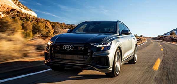
    • Work zone warnings, which the organizations feel is an important use case on highways, featuring a Qualcomm 9150 C-V2X chipset solution via an in-vehicle display in Audi Q8 SUVs designed to deliver a graduated warning, with the last link being a low-latency, reliable warning to drivers of the workers’ physical presence.
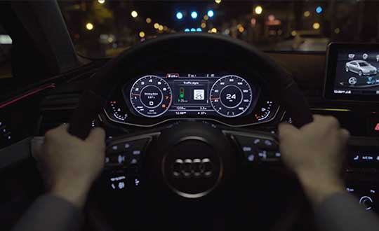
    • On arterial roadways, the signal phase and timing (SpaT) from a traffic signal, will be transmitted with a Qualcomm 9150 C-V2X chipset solution to Audi Q8 SUVs. These vehicles have the Audi Traffic Light Information (TLI) service that can provide drivers a countdown to the green light. C-V2X from the traffic signal can also provide direct information to the Audi Q8, which will be used by the TLI system to fine-tune the countdown information of the signal phase and timing.

    “VDOT has long supported research into the benefits of connected and automated vehicles, particularly those aspects that have the potential to significantly enhance safety,” said Virginia’s Director of Transportation Research and Innovation Cathy McGhee. “The inclusion of shorter-range, direct communication in the 5.9 GHz band using C-V2X is exciting, as it can allow us to evaluate this emerging communication option for essential and practical safety and mobility services, including saving the lives of maintenance and construction personnel in work zones.”

    Photo: Audi
    Photo: Audi

    “We recognize the immediate value of the spectrum that the FCC proposed to allocate to C-V2X, and we endeavor to show our V2X equipped cars on real roads engaging in how transportation safety and mobility could be jump-started,” said Anupam Malhotra, Director, Connected Vehicle Services, Audi of America. “We are excited about our participation in this pilot deployment as it highlights the broad societal advantages that technology is now poised to deliver through the full 5.9 GHz V2X spectrum near term with far, far more to come as connected and automated vehicle fleets emerge over the next decade.”

    Audi’s Traffic Light Information V2X services operate in 25 cities and nearly 10,000 intersections nationwide, including more than 1,700 intersections in the Washington D.C. metropolitan region.

    “Qualcomm Technologies is excited to work with the VDOT, through its partner Virginia Tech and Audi to support the C-V2X use cases on the very same spectrum that the FCC has proposed to allocate for C-V2X. Qualcomm Technologies has long been a pioneer in the connected car with over 20 years of experience delivering in-vehicle telematic systems,” said Jim Misener, senior director, product management, Qualcomm Technologies, Inc. “With the advances in cellular communications now enabling us to also offer direct connectivity for safety services, traffic efficiency and emerging automated use cases, we are pleased to work closely with VDOT, Audi of America and Virginia Tech to showcase the commercial maturity and technological sophistication of C-V2X and to start the proliferation of the technology on U.S. roadways.”

    The Virginia Tech Transportation Institute (VTTI) will develop the software and systems to support the primary use cases defined for the initial deployment. Following software development, the institute will then conduct a demonstration of C-V2X technology operating in these use cases.

    C-V2X Features and Benefits

    • The C-V2X solution used in this initial deployment is based on third-generation partnership project (3GPP) Release 14 and Release 15 specifications. Direct communication of this solution uses 20 MHz from the 5.905 – 5.925 GHz ITS band, the same spectrum that the FCC has proposed allocating for C-V2X.
    • A more advanced mode of C-V2X has an evolution path to 5G using 3GPP Release 16 specifications.
      Field test results issued by the 5G Automotive Association (5GAA) have proven C-V2X to be an efficient and effective radio access technology, showing that it significantly increases in range and reliability compared to other radio technologies.
    • C-V2X commercial products are now widely available in the form of multiple chip platforms, wireless modules, vehicular Onboard Units and infrastructure Roadside Units.
    • C-V2X encompasses both direct short-range communications that operate in the 5.9GHz ITS band and longer-range network communications delivered by mobile network operators; chipsets now offer both direct and network connectivity in the same solution concurrently, aiding in the adoption of the technology.

    For more information about the Traffic Light Information technologies on Audi models in select markets, visit www.media.audiusa.com.

  • U-blox L-band receiver enables cm-level positioning for mass market

    U-blox L-band receiver enables cm-level positioning for mass market

    Photo: u-blox
    Photo: u-blox

    U-blox said its new NEO-D9S GNSS correction data receiver module provides an affordable approach to bringing centimeter-level accuracy to GNSS receivers.

    The NEO-D9S receives from correction service providers broadcast on the L-band (1525-1559 MHz). A host processor can then decrypt this correction data and provide it to a high-precision GNSS receiver, combining corrections directly with readings from the satellite constellations to enable much more accurate position readings than those offered by GNSS signals alone.

    Use of the NEO-D9S will also increase the availability of high-precision GNSS positioning data in areas with limited connectivity and reduce the amount of cellular data consumed by positioning receivers.

    Customers are expected to include carmakers, both Tier 1 and OEMs, industrial system integrators that offer position-correction services, and any other applications that rely on very accurate positioning at low cost.

    The NEO-D9S module is a correction-only receiver, based on the latest u-blox ninth-generation (D9) platform. This means that it will integrate easily with the u-blox F9 RTK GNSS receivers from u-blox, or can be used as part of a modular product roadmap. The module also integrates a TCXO and SAW filter to ensure good RF sensitivity and resilience to interference from adjacent channels.

    The module includes the algorithms necessary to decode satellite data broadcasts. It is configured to work initially with whichever correction service has been set as default, but can be configured for any L-band data broadcast. It stores its configuration settings in non-volatile memory.

  • Airbus reminds pilots what to do when GNSS interference hits

    Airbus reminds pilots what to do when GNSS interference hits

    Airbus is providing safety information to all pilots, not just those of the new BelugaXL. (Photo: Airbus)
    Airbus is providing safety information to all pilots, not just those of the new BelugaXL. (Photo: Airbus)

    Commercial airline pilots should be ready if their GNSS interference or jamming takes place. This safety message, along with steps to take, was provided by Airbus in the January issue of its publication “Safety First.”

    In the publication, Airbus is reminding pilots of the consequences and required action in the cockpit, according to Aviation Week. Loss of the GNSS signal can affect navigation and surveillance functions. While built-in redundancies will maintain position computation, up to a dozen systems and functions can be affected.

    Cover: Airbus
    Cover: Airbus

    “A loss of GNSS inputs does not lead to a map shift or an erroneous position computation by the FMS (Flight Management System). In the case of a loss of GPS signal, the FMS switches from the mixed GPS/IRS position to an IRS-DME/DME position or IRS-VOR/DME or pure IRS, in order of priority,” the experts explain in the publication.

    Other affected systems can include the predictive functions of the terrain awareness and warning system, the runway overrun protection system, and ADS-B Out, in which case pilots should notify air traffic control.

    Once the flight is over, pilots should report the GNSS interference event to air navigation service providers.

  • Marine vessels to use Oceaneering C-Nav positioning

    Oceaneering C-Nav Positioning Solutions to provide C-Nav5000 GNSS receivers for select SEACOR marine vessels

    The C-Nav5000 GNSS receiver. (Photo: Oceaneering)
    The C-Nav5000 GNSS receiver. (Photo: Oceaneering)

    Oceaneering C-Nav Positioning Solutions has been selected by SEACOR Marine to supply C-Nav5000 GNSS receivers for a select number of the company’s oil-and-gas support vessels worldwide.

    The scope of work calls for C-Nav to provide two C-Nav5000 GNSS systems per vessel. SEACOR will license corrections signals from C-Nav while the equipment is onboard and the vessels are working. C-Nav expects to install the C-Nav5000 receiver on seven vessels by year’s end.

    “We are delighted to have been selected by SEACOR to provide our precise point positioning receivers onboard their vessels,” said David Fitts, senior manager, C-Nav Positioning Solutions. “Our receivers will provide SEACOR vessels with the latest in GNSS hardware.”

    The C-Nav5000 offers integrated GNSS capabilities that allow tracking of multiple systems. It features triple L-band channels for correction tracking and is software-configurable to user requirements.

  • Research Roundup: Focus on maritime

    Research Roundup: Focus on maritime

    The 18,000-container-capacity CMA CGM Kuergelen. (Photo: CMA CGM)
    The 18,000-container-capacity CMA CGM Kuergelen. (Photo: CMA CGM)

    Of the 273 papers researchers presented this year at the Institute of Navigation’s annual ION GNSS+ conference, which took place in Miami on Sept. 16–20, the following five focused on maritime issues. Papers are available at www.ion.org/publications/browse.cfm.

    Automating the Sharing of Ocean Weather Data

    The Automatic Identification System (AIS) — mandatory for large ships and used by many mid-sized ones — was designed to help avoid collisions, enable shore authorities to provide vessel traffic services, and allow coastal states to monitor their waters. It also may be used to transmit other information between AIS stations onboard and ashore.

    In the aftermath of the sinking of the container ship El Faro in 2015, the U.S. National Transportation Safety Board (NTSB) and U.S. Coast Guard found a contributing factor was lack of reliable weather forecasts. The NTSB then recommended to the National Oceanic and Atmospheric Administration (NOAA) that it determine whether AIS could be used to share weather data collected by ships, to supplement the Voluntary Observing Ship (VOS) program where ships voluntarily submit weather observations to NOAA. The paper describes a successful test of this concept.

    Citation. Gregory Johnson, Ken Dykstra, Gaurav Dhungana and Brian Tetreault, “Sharing Ships’ Weather Data via AIS.”

    EGNOS for Maritime Navigation

    The European Geostationary Navigation Overlay System (EGNOS), which has been providing guidance to civil aviation since 2011, also can support maritime, railway and road applications. This paper assesses its use for maritime navigation compliant with International Maritime Organization (IMO) requirements for harbor entrances, harbor approaches and coastal waters: 99.8% of signal availability, 99.8% of service availability, 99.97% of service continuity, and 10 meters of horizontal accuracy. A kinematic test campaign was conducted in the waters of the Canary Islands using a geodetic multi-frequency, multi-constellation receiver-antenna pair installed aboard two vessels. The EGNOS Maritime Service met all IMO requirements by achieving a signal availability of 99.999%, a service availability in 99.9% of a predefined rectangular region, and 1.06 meters of horizontal accuracy at the 95th percentile. The service continuity requirement, however, was met in only 62.50% of the predefined region. Therefore, the paper concludes that the continuity risk is the most limiting factor for expanding the EGNOS Maritime Service along the coastal waters of the Canary Islands.

    Citation. Deimos Ibáñez Segura, Adria Rovira Garcia, Jaume Sanz, José Miguel Juan, Guillermo González Casado, María Teresa Alonso, José A. López Salcedo, Huamin Jia, Francisco Javier Pancorbo Garcia, Carlos Garcia Daroca, Irene Martin Calle, Santos Rodrigo Abadía Heredia and Manuel López Martínez, “A Kinematic Campaign to Evaluate EGNOS 1046 Maritime Service.”

    Options for Integrity

    Many maritime authorities are considering how to maintain the integrity of navigation systems as their infrastructure ages, especially given that the need for integrity in the user position is expected to increase with e-navigation services and for autonomous vessels. In harbor entrances, harbor approaches and coastal waters, the International Association of Marine Aids to Navigation and Lighthouse Authorities (IALA) prescribes an absolute horizontal accuracy of ≤10 meters 95% of the time, with an integrity risk of 99.99999%. Today’s GNSS more than meets that accuracy requirement, so the driver is integrity. Options for integrity are marine radiobeacon DGPS/DGNSS, the primary augmentation system in use today; receiver autonomous integrity monitoring (RAIM); satellite-based augmentation systems (SBAS); and others (such as commercial services or inertial.). The European MarRINav project is investigating resilient PNT options to support UK Critical National Infrastructure. Part of this work is comparing EGNOS and marine radiobeacon DGPS performance to inform international discussions and receiver standardization.

    Citation. Alan Grant, George Shaw and Martin Bransby, “Considering SBAS and marine radiobeacon corrections to support safe maritime operations.”

    Evaluation of WAAS for Use in Canadian Waters

    Mariners navigating in Canadian waters use a ground-based augmentation system (GBAS) that provides differential corrections and integrity monitoring of GPS. This GBAS has been provided since 1994 by the Canadian Coast Guard (CCG) in the form of a differential GPS (DGPS) broadcast service. The service is only provided south of latitude 60°N in collaboration with the U.S. Coast Guard. Before embarking on a recapitalization program of its 24-year-old DGPS, and given that the U.S. Coast Guard is progressively shutting down its National Differential GPS sites, the CCG is evaluating options for its own DGPS network. Options include the wide-area augmentation system (WAAS), originally developed by the U.S. Federal Aviation Administration for civil aviation. This paper describes the authors’ evaluation for the CCG to determine the expected accuracy, integrity and availability of WAAS throughout Canadian waters, concluding that the current WAAS provides acceptable accuracy and integrity for most of Canada, excluding the higher latitudes.

    Citation. Gregory Johnson, Gaurav Dhungana and Jean Delisle, “An Evaluation of WAAS 2020+ to Meet Maritime Navigation Requirements in Canadian Waters.”

    GNSS + INS for Attitude Determination

    Attitude determination (AD) is an important navigation component for ships and spacecraft. GNSS enables resolving their orientation in a precise and absolute manner, by employing multiple antennas rigidly mounted on the vessel. This requires carrier-phase observations, with the consequent added complexity of resolving integer ambiguities. Inertial aiding has been extensively exploited for AD, because it enables tracking fast rotation variations and bridging short periods of GNSS outage. In this paper, the fusion of inertial and GNSS information is exploited within the recursive Bayesian estimation framework, applying an Error State Kalman Filter, which, unlike common Kalman filters, tracks the error or variations in the state estimate, posing meaningful advantages for AD. The results show that the inertial aiding, along with a constrained attitude model for the float estimation, significantly improve the performance of attitude determination compared to classical unaided baseline tracking.

    Citation. Daniel Medina, Vincenzo Centrone, Ralf Ziebold, and Jesús García, “Attitude Determination via GNSS Carrier Phase and Inertial Aiding.”

  • US Department of Transportation updates guidelines on autonomous vehicles

    US Department of Transportation updates guidelines on autonomous vehicles

    Image: USDOT
    Image: USDOT

    The U.S. Department of Transportation on Wednesday released updated guidelines for autonomous vehicles.

    “Ensuring American Leadership in Automated Vehicle Technologies: Automated Vehicles 4.0” (AV 4.0) was announced by U.S. Transportation Secretary Elaine L. Chao in a keynote speech at CES 2020 in Las Vegas.

    AV 4.0 unifies efforts in automated vehicles across 38 federal departments, independent agencies, commissions and executive offices, providing high-level guidance to state and local governments, innovators and stakeholders on the U.S. government’s approach toward autonomous vehicles.

    “AV 4.0 will ensure American leadership in AV technology development and integration by providing unified guidance for the first time across the federal government for innovators and stakeholders,” Chao said.

    AV 4.0 establishes federal principles for the development and integration of automated vehicles, consisting of three core focus areas: prioritize safety and security, promote innovation, and ensure a consistent regulatory approach.

    It also outlines ongoing administration efforts supporting autonomous vehicle technology growth and leadership, as well as opportunities for collaboration including federal investments in the sector and resources for innovators, researchers and the public.

    “AV 4.0 brings all of the important work happening on automated vehicle technologies across the federal government under one unified approach. The federal principles released today help foster an environment for innovators to advance safe AV technologies, and put the U.S. in a position of continued leadership in the future of transportation,” said U.S. Chief Technology Officer Michael Kratsios.

    The USDOT is preparing for emerging technologies by engaging with new technologies to address legitimate public concerns about safety, security and privacy without hampering innovation, the department said in a press release.

    With the release of “Automated Driving Systems 2.0: A Vision for Safety” (ADS 2.0) in September 2017, the USDOT provided voluntary guidance to industry, as well as technical assistance and best practices to states, offering a path forward for the safe testing and integration of Automated Driving Systems.

    In October 2018, “Preparing for the Future of Transportation: Automated Vehicles 3.0” (AV 3.0) introduced guiding principles for autonomous vehicle innovation for all surface transportation modes, and described the USDOT’s strategy to address existing barriers to potential safety benefits and progress.

    “AV 4.0 builds on these efforts by presenting a unifying posture to inform collaborative efforts in automated vehicles for all stakeholders and outlines past and current federal government efforts to ensure the United States leads the world in AV technology development and integration while prioritizing safety, security, and privacy and safeguarding the freedoms enjoyed by Americans,” the press release stated.

    AV 4.0 will be published in the Federal Register for public review and comment. More information on the USDOT’s work on automated vehicles can be found at https://www.transportation.gov/av/4.

  • Launchpad: Handheld and UAV receivers, GNSS antennas

    Launchpad: Handheld and UAV receivers, GNSS antennas

    A roundup of recent products in the GNSS and inertial positioning industry from the January 2020 issue of GPS World magazine.


    OEM

    Heavy-duty antenna

    For challenging environments

    AT311 antenna. (Photo: CHC Navigation)
    AT311 antenna. (Photo: CHC Navigation)

    The heavy-duty CHCNAV AT311T is designed for demanding applications subject to shocks and vibrations. With advanced filtering and robust signal tracking, it provides survey-grade GNSS signals to enhance position reliability for marine applications, machine control, precision agriculture and industrial automation. Features include multi-constellation GNSS tracking using GPS, GLONASS, BeiDou, Galileo, QZSS, IRNSS and SBAS. Its IP68 water-resistant design makes it safe to use in extreme conditions with a wide temperature range (–40° C to +85° C). Its internal stacked structure enhances performance in high-interference environments, and the 40-dB signal gains, advanced signal filtering and multipath rejection design provide superior and robust GNSS signal tracking in challenging surroundings.

    CHC Navigation, www.chcnav.com

    UAV GNSS board

    Compact, high-precision for UAS

    The UAS1 GNSS receiver module has been designed for UAV/UAS applications requiring centimeter accuracy in a small package.(Photo: Trimble)
    The UAS1 GNSS receiver module has been designed for UAV/UAS applications requiring centimeter accuracy in a small package.(Photo: Trimble)

    The UAS1 compact, high-precision GNSS board was designed for unmanned aerial systems (UAS). It allows UAS system integrators to add upgradeable GNSS-based positioning using rugged connectors and Trimble’s software interface. Its 336-channel GNSS engine is capable of tracking L1/L2 frequencies from GPS, GLONASS, Galileo and BeiDou for centimeter-level, real-time kinematic (RTK) positioning. The compact board provides capabilities from high-accuracy GPS-only to full GNSS features. The receiver supports fault detection and exclusion (FDE) and receiver autonomous integrity monitoring (RAIM). System integrators also have the ability to detect interference with an RF spectrum monitoring and analysis tool embedded in the receiver.

    Trimble, trimble.com

    Upgradeable OEM board

    Offers software-enabled features

    Photo: NavCom
    Photo: NavCom

    The Onyx multi-frequency GNSS OEM board offers integrated StarFire/real-time kinematic (RTK) GNSS capabilities. It features 255-channel tracking, including multi-constellation support for GPS, GLONASS, BeiDou and Galileo. It provides high performance in GNSS receiver sensitivity and signal tracking as well as patented multipath mitigation, interference rejection and anti-jamming capabilities. Through software options, the Onyx ,allows upgrades from free differential GPS signal sources such as WAAS, to increased accuracy services such as StarFire and RTK Extend. The software-enabled features are sold in bundles, but can also be purchased individually to suit changing application needs.

    NavCom Technology, www.navcomtech.com

    Network timing

    Sub-microsecond synchronization

    The OSA 5401 and OSA 5405 now enable power utility and broadcast networks to achieve sub-microsecond synchronization. (Photo: Business Wire)
    The OSA 5401 and OSA 5405 now enable power utility and broadcast networks to achieve sub-microsecond synchronization. (Photo: Business Wire)

    The OSA 5401 and OSA 5405 upgraded PTP grandmaster clocks deliver precise, robust timing in a compact form factor. Oscilloquartz PTP timing technology enables power utility and broadcast networks to achieve sub-microsecond synchronization. The pluggable OSA 5401 is a small PTP grandmaster clock, and the OSA 5405 is an integrated PTP grandmaster with dual GNSS antenna and receiver. With spoofing and jamming detection capabilities, they also provide high availability. The OSA 5401 and 5405 provide new levels of accuracy and resilience for infrastructure and support emerging bandwidth-intensive, latency-sensitive applications. With sub-microsecond synchronization, smart grids can perform flexible, real-time decision making, as well as monitoring and automated maintenance. The OSA 5401 and OSA 5405 comply with the latest PTP profiles for time, frequency and phase synchronization in both power utility and broadcast networks. These include the IEC/IEEE 61850-9-3 Power Utility Profile for precise time distribution and clock synchronization in electrical grids with an accuracy of 1μs, and SMPTE 2059 for synchronizing video and audio equipment over packet networks.

    Adva, www.adva.com


    TRANSPORTATION

    Aircraft GPS

    Helps with ADS-B Out compliance

    CMA-5024. (Photo: CMC Electronics)
    CMA-5024. (Photo: CMC Electronics)

    The SBAS-capable CMA-5024 GPS has received U.S. Federal Aviation Administration (FAA) approval for installation on Boeing 737 Next-Generation aircraft. It enables B737NGs to comply with worldwide ADS-B Out mandates as well as SBAS/GPS navigation, enabling the first localizer performance with vertical guidance (LPV) approaches for B737NGs. The CMA-5024 GPS is a cost-effective alternative to replace a multi-mode receiver (MMR). The approved DO-260B ADS-B Out positioning source can be paired with any DO-260B compliant transponder, allowing operators to meet FAA and EASA ADS-B Out requirements, the UAE’s ADS-B Out and RNP requirements mandated by GCAA as well as India’s GAGAN requirements.

    CMC Electronics, www.cmcelectronics.ca

    ADS-B transmitter

    Receives FAA approval

    Photo:
    Photo: uAvionix

    The U.S. Federal Aviation Administration (FAA) has approved the VTU-20 automatic dependent surveillance – broadcast (ADS-B) transmitter for airport surface management. Adhering to the performance and design assurance specifications of FAA-E-3032, the externally mounted VTU-20 ensures integration and interoperability with Airport Surface Detection Equipment, Model X (ASDE-X), Airport Surface Surveillance Capability (ASSC) and ADS-B receiver surveillance solutions for airport. The VTU-20 can be permanently or magnetically mounted to all airside vehicles, including utility, emergency, snow-removal and maintenance equipment. Each vehicle is clearly and uniquely identified, providing an essential addition to any surface movement guidance and control system.

    uAvionix, uavionix.com


    UAV

    Airspace Intelligence

    Provides critical safety data to drone pilots

    Image: Skyward
    Image: Skyward

    Skyward’s Advanced Airspace Intelligence drone airspace maps provide airspace data combined with essential ground intelligence including 3D views of key structures, transmission lines, and more than a million vertical obstacles. The platform also provides access to LAANC, the Low Altitude Authorization and Notification Capability program provided by the U.S. Federal Aviation Administration. Data available for situational awareness includes vertical structure obstacles, power lines, airports, runways, national parks, stadiums, hospitals and schools.

    Skyward, skyward.io

    PPK for Phantom 4 RTK drones

    Provides reliable camera positioning data

    Screenshot: Hi-Target
    Screenshot: Hi-Target

    Hi-Target PPK GO precision add-on enables Phantom 4 RTK drones to achieve the accurate and reliable camera positioning data in any coordinate system without measure targets or ground control points. With 2-centimeter accuracies on XYZ, the output text file with position information or geotagged images can be used directly in major photogrammetric mapping or 3D survey software. The add-on allows selection of GPS/GLONASS/Beidou/ Galileo L1+L2+L5 and further parameter adjustments for position calculation in the PPK process to ensure the most reliable and accurate camera positioning even in poor single satellite system signals.

    Hi-Target, en.hi-target.com.cn


    SURVEYING & MAPPING

    GNSS Receiver

    Full-featured positioning system

    The R620 GNSS receiver is a complete refresh of Hemisphere's previous version, the R330. (Photo: Allison Barwacz)
    The R620 GNSS receiver is a complete refresh of Hemisphere’s previous version, the R330. (Photo: Allison Barwacz)

    The next-generation R620 receiver is designed for land and marine applications requiring high-precision positioning. It is a complete refresh of the previous version (R330) and has a new low-profile ruggedized enclosure. Customers can start with sub-meter positioning accuracy and upgrade the receiver through activations and subscriptions to add functionality and improve performance capability to centimeter-level accuracy. Powered by the Vega series, the R620 GNSS receiver processes and supports more than 1,100 channels. It simultaneously tracks GPS, GLONASS, BeiDou (including Phase 3), Galileo, QZSS, IRNSS, SBAS and Atlas L-band corrections. It has status LEDs , a powerful WebUI, UHF (400-MHz and 900-MHz) radio, cellular modem, Bluetooth, Wi-Fi, Ethernet (including power over Ethernet), CAN, serial and USB.

    Hemisphere GNSS, hemispheregnss.com

    Rugged data collector

    For land surveying and geospatial information systems (GIS)

    Photo: Geneq
    Photo: Geneq

    The rugged SXPad 1500 data collector features an alphanumeric keypad and long-range Bluetooth, and was designed to meet the rigorous IP67 standard for challenging field conditions. It has a 5-inch sunlight-readable touchscreen. The SXPad 1500 can be connected to any GNSS receiver or compatible robotic total station. Driven by a 1-GHz processor and the Windows Mobile 6.5 operating system, providing the power to work with maps and large data sets in the field. Its integrated cellular modem and Wi-Fi provides wireless connectivity for internet access and GIS data transfer — helpful for configuring a real-time kinematic (RTK)-compatible GNSS receiver. Equipped with an internal memory of 1 GB (memory can be expanded to 16 GB with an SD card), the SXPad 1500 provides enough storage space for data recording. Its high-performance lithium battery allows uninterrupted field operation for up to eight hours.

    Geneq, sxbluegps.com

    GNSS RTK tablet

    Receives 184 channels

    Photo: CHC Navigation
    Photo: CHC Navigation

    The LT700H RTK Android tablet is designed to increase efficiency and productivity of the mobile field workforce in applications requiring centimeter-to-decimeter positioning accuracy. Portable, rugged and versatile, the LT700H enables precision GIS data collection, forensic mapping, construction site layout, environmental surveys, landscaping and earthmoving jobs. Powered by 184-channel high-performance GPS, GLONASS, Galileo and BeiDou module and a superior tracking GNSS helical antenna, the LT700H provides position availability in demanding environments. Its integrated 4G modem ensures seamless communication from field-to-office and robust connectivity to RTK correction networks.

    CHC Navigation, www.chcnav.com

    Reference receiver

    Now supports BDS-3 signals

    Photo: Trimble
    Photo: Trimble

    The Trimble Alloy GNSS reference receiver now supports BeiDou Generation III (BDS-3) signals. This will enable operators to meet the ongoing demand from surveyors, mapping professionals and precision farmers for accurate, reliable corrections derived from real-time networks. Released in 2018, the Alloy has the processing power needed for high-quality data from multiple constellations. Alloy version 5.42 firmware tracks all available and planned GPS Block IIIA L1C and BDS-3 signals.

    Trimble, www.trimble.com

    Utility mapping

    Ground penetrating radar

    Hexagon showcased the Leica DSX utility detection solution at Intergeo 2019. (Photo: Allison Barwacz)
    Hexagon showcased the Leica DSX utility detection solution at Intergeo 2019. (Photo: Allison Barwacz)

    The Leica DSX utility detection solution can be used together with Leica GPS/GNSS systems to generate highly accurate, georeferenced maps. The DSX uncovers utilities for repair and maintenance, civil engineering and surveying projects. The ground-penetrating radar system includes portable hardware and software that automates data analysis and creates a 3D utility map.

    Hexagon, hexagon.com

  • Qualcomm Snapdragon Ride platform designed for autonomous vehicles

    Qualcomm Technologies unveiled at CES 2020 its newest addition to the company’s portfolio of automotive products — the Qualcomm Snapdragon Ride Platform.

    Snapdragon Ride is an advanced, scalable and open autonomous driving solution consisting of the family of Snapdragon Ride Safety system-on-chips (SoCs), Snapdragon Ride Safety Accelerator and Snapdragon Ride Autonomous Stack.

    CES 2020, the massive annual consumer electronics show, is taking place Jan. 7-10 in Las Vegas.

    Snapdragon Ride aims to address the complexity of autonomous driving and ADAS by leveraging its high-performance, power-efficient hardware, industry-leading artificial intelligence (AI) technologies and pioneering autonomous driving stack to deliver a comprehensive, cost and energy efficient systems solution.

    The unique combination of Snapdragon Ride SoCs, accelerator and autonomous stack offers automakers a scalable solution designed to support three industry segments of autonomous systems, namely L1/L2 Active Safety ADAS for vehicles that include automatic emergency braking, traffic sign recognition and lane keeping assist functions; L2+ Convenience ADAS for vehicles featuring Automated Highway Driving, Self-Parking and Urban Driving in Stop-and-Go traffic; and L4/L5 Fully Autonomous Driving for autonomous urban driving, robo-taxis and robo-logistics.

    The Snapdragon Ride Platform, based on the Snapdragon family of automotive SoCs and accelerator, is built on scalable and modular heterogeneous high-performance multi-core CPUs, energy efficient AI and computer vision (CV) engines, industry-leading GPU.

    The platform with combination of SoCs and accelerator can be used as needed to address every market segment offering industry-leading thermal efficiency, from 30 Tera Operations Per Second (TOPS) for L1/L2 applications to over 700 TOPS at 130W for L4/L5 driving.

    The platform can therefore result in designs that can be passively or air-cooled, thereby reducing cost, and increasing reliability, avoiding the need for expensive liquid cooled systems and allowing for simpler vehicle designs, and extending the driving range for electric vehicles. The Snapdragon Ride SoCs and accelerator are designed for functional safety ASIL-D systems.

    Snapdragon Ride is expected to be available for pre-development to automakers and tier-1 suppliers in the first half of 2020. Qualcomm Technologies anticipates Snapdragon Ride-enabled vehicles to be in production in 2023.

    While the company believes the next wave of innovation may be in the L2+ Convenience ADAS segment, the hardware solutions utilized in Snapdragon Ride from a single system-on-chip (SoC) for an Active Safety ADAS system driven by regulatory mandates to a highly scalable architecture of multiple SoCs and dedicated autonomous driving accelerators allowing for fully autonomous self-driving systems.

    Qualcomm Technologies’ family of ADAS SoCs and accelerators are built on the fundamental approach of heterogeneous compute capabilities designed for application requirements.

    These ADAS SoCs and accelerators effectively manage a large amount of data from onboard systems, leveraging Qualcomm Technologies’ next generation AI engines; image signal processors for camera sensors; enhanced digital signal processors (DSPs) for sensor signal processing; high-performance CPUs for planning and decision making; cutting-edge GPU technology for high-end visualization and immersive user experience; dedicated safety and security subsystems across the SoC and autonomous driving accelerator.

    Through the autonomous driving accelerator, Qualcomm Technologies brings energy efficient compute capabilities to mainstream vehicles, which has so far been largely unavailable to the automotive industry due to exceptionally complex and expensive thermal solutions that are fundamentally unscalable because of their power consumption requirements.


    Snapdragon Ride Benefits

    • Proven and integrated safety board support package with safe OS and hypervisors
    • Safety frameworks from automotive industry leaders, including Adaptive AUTOSAR
    • Optimized and comprehensive foundational function libraries for computer vision, sensor signal processing, and standard arithmetic libraries
    • AI tools for improving model efficiencies, as well as optimizing runtime on heterogeneous compute units
    • Comprehensive autonomous driving stack for highway functions, such as perception and planning for highway driving functions
    • Cost-efficient localization solution with Qualcomm Vision Enhanced Precise Positioning (VEPP)
    • Hardware and Software in Loop Test environment
    • Data Management Tools for intelligent data collection and automated annotation

    Autonomous Stack

    Integrated as a part of Snapdragon Ride is Qualcomm Technologies’ new purpose-built autonomous driving software stack, a modular and scalable solution available to automotive OEM and tier-1 suppliers to accelerate their development and innovations.

    The software stack facilitates automakers’ abilities to offer increased safety and comfort to everyday driving by offering optimized software and applications for complex use cases, such as self-navigating human-like highway driving, as well as choice of modular options like perception, localization, sensor fusion and behavior planning.

    The software infrastructure for Snapdragon Ride supports customer specific stack components to be co-hosted with the Snapdragon Ride Autonomous Stack components.

    “Over the years, we have consistently demonstrated our prowess in large-scale deployment of high-performance and highly intelligent cockpit and connected car solutions that operate in power-constrained environments across virtually every class of vehicle. Today, we are pleased to be introducing our first-generation Snapdragon Ride platform, which is highly scalable, open, fully customizable and highly power optimized autonomous driving solution designed to address a range of requirements from NCAP to L2+ Highway Autopilot to Robo Taxis. Combined with our Snapdragon Ride Autonomous Stack, or an automaker or tier-1’s own algorithms, our platform aims at accelerating the deployment of high-performance autonomous driving to mass market vehicles,” said Nakul Duggal, senior vice president, product management, Qualcomm Technologies, Inc. “We’ve spent the last several years researching and developing our new autonomous platform and accompanying driving stack, identifying challenges and gathering insights from data analysis to address the complexities automakers want to solve.”

  • HERE’s new HD GNSS enables sub-meter positioning for mass market

    HERE’s new HD GNSS enables sub-meter positioning for mass market

    The company also announces that HERE Navigation On-Demand is OEM-ready with APCOA as partner

    HERE Technologies has introduced at CES 2020 its High Definition Global Navigation Satellite System (HD GNSS) positioning, a cloud-based solution that enables mass-market devices to achieve sub-meter accuracy across the globe.

    CES 2020, the massive annual consumer electronics show, is taking place Jan. 7-10 in Las Vegas. Here’s booth is at Central Plaza, Tech East.

    HD GNSS enables new user experiences with lane-level navigation, augmented and virtual reality. It combines precise point positioning (PPP) and real-time kinematic (RTK) positioning methods, allowing for fast convergence time, high availability and global coverage.

    It also supports off-the-shelf mobile devices and internet of things (IoT) trackers equipped with dual frequency chipsets such as the Broadcom BCM47765 and BCM47755.

    Photo: HERE
    Photo: HERE

    More mass-market devices and vehicles are being equipped with dual-frequency GNSS receivers. With the HD GNSS service, the receivers enable high-precision positioning, HERE said, a capability that was cost and geographically prohibitive less than two years ago.

    HERE HD GNSS accelerates chipset, hardware and software makers’ ability to offer a step change in what can be delivered to consumers in new product capabilities, features and user experiences, the company said.

    HERE HD GNSS data delivery is optimized for mobile devices, requires no additional hardware and comes equipped with spoofing detection and phone sensor integration. It provides global coverage (including China and Japan), with single-frequency mobile device support in the future.

    HERE is also working across a partner ecosystem — including reference station operators, chipset manufacturers, module makers, hardware vendors, mobile network operators and system integrators — to jointly improve the positioning accuracy to centimeter levels, and in more challenging environments such as urban canyons.


    Automotive use cases

    Autonomous driving. For safety, it’s critical that automated vehicles are designed with high levels of redundancy in positioning systems. If an automated vehicle gets caught in bad weather conditions which are degrading optical sensor operations, <0.2m positioning accuracy available via HD GNSS increases safety and operation time in autonomous mode.

    Assisted driving. In case of an obstacle on the road, HD GNSS combined with HERE HD maps provide obstacle indication and avoidance functionality.

    Mobile device use cases

    Road lane guidance and improved ETAs on mobile devices. If a driver is unfamiliar with the roadway, HERE HD GNSS, combined with precision HERE map data, shows the driver the correct lane and path to navigate to the destination fast and safely.

    Improved gaming and augmented reality experience. Location-based games are growing and widely popular, however they currently rely on less accurate positioning technologies that inhibit next generation use cases. HERE HD GNSS bring exciting opportunities to design the next version of games with sub-meter positional accuracy.


    HERE Navigation On-Demand is OEM-ready with APCOA as partner

    HERE Navigation On-Demand is now available for integration in OEM infotainment programs. APCOA Parking is the first non-automotive company to use the Service Package SDK to make its parking services available on HERE Navigation On-Demand.

    HERE Technologies’ software-as-a-service solution HERE Navigation On-Demand is available for integration in OEM infotainment programs. With HERE Navigation On-Demand, OEMs and Tier 1 vendors get to deliver both connected services and expandable navigation experiences on both embedded and mobile platforms.

    The connected solution cuts development and lifecycle costs by offering cutting-edge, off-the-shelf functionalities while enabling OEMs and Tier 1 vendors to use an SDK to build their own features or integrate third party services.

    As a software-as-a-service offering, HERE Navigation On-Demand enables OEMs to remotely configure and monitor the deployed navigation solution making it possible to update and upgrade the experience anytime, even after the sale of the vehicle.

    OEMs can further offer any functionality as a subscription option and thus generate new, recurring revenue streams. The end-user accesses the navigation experience through client software which downloads the Service Packages from the cloud.

    The highly modular Service Packages include map data, software features, UX elements and references to Cloud Service APIs. Smart caching of these Service Packages ensures that HERE Navigation On-Demand also works offline.

    Alexa, Amazon’s cloud-based voice service, is pre-integrated into HERE Navigation On-Demand, making it faster and easier for automakers to deliver an intuitive, voice-first navigation experience to customers in the car.

  • NovAtel delivers signal generators to modernize FAA’s WAAS

    NovAtel delivers signal generators to modernize FAA’s WAAS

    Next-generation NovAtel ground uplink station signal generators delivered for SBAS modernization

    Photo: NovAtel
    Photo: NovAtel

    Hexagon/NovAtel announced that shipments of next-generation ground uplink station (GUS) signal generators have commenced in fulfillment of its contract with the United States Federal Aviation Administration (FAA) to support the FAA’s safety of life wide-area augmentation system (WAAS) navigation service.

    Developed by the FAA for civil aviation, WAAS is a safety-critical navigation aid that provides integrity monitoring and differential corrections for all phases of flight. The next-generation NovAtel GUS signal generator replaces the legacy product that has operated successfully for more than 15 years and ensures continued operation for years to come.

    Along with the GUS signal generator modernization, the contract includes ongoing engineering support services for the complete portfolio of NovAtel ground reference receiver products deployed by the FAA.

    “We have a long-standing relationship with the FAA and worked very closely with the WAAS program team to deliver this critical next-generation technology for SBAS modernization,” stated Jonathan Auld, NovAtel Vice President of Engineering and Safety Critical Systems. “We’re very pleased to continue our commitment to support the FAA and their safety of life WAAS service.”

  • Uber and Hyundai release full-scale air taxi model at CES

    Hyundai is the first Uber Elevate partner with manufacturing capabilities to mass produce Uber Air Taxis

    Uber and Hyundai Motor Company announced at CES 2020 a new partnership to develop Uber Air Taxis for a future aerial ride-share network and unveiled a full-scale aircraft concept. Hyundai is the first automotive company to join the Uber Elevate initiative, bringing automotive-scale manufacturing capability and a track record of mass-producing electric vehicles.

    CES 2020, the massive annual consumer electronics show, is taking place Jan. 7-10 in Las Vegas. Hyundai Motor’s innovative smart mobility solutions including UAM, PBV, Hub and more are showcased at Booth 5431 in the Las Vegas Convention Center North Hall.

    The taxi concept was created in part through Uber’s open design process, a NASA-inspired approach that jump starts innovation by publicly releasing vehicle design concepts so any company can use them to innovate their air taxi models and engineering technologies.

    In this partnership, Hyundai will produce and deploy the air vehicles, and Uber will provide airspace support services, connections to ground transportation, and customer interfaces through an aerial ride-share network. Both parties are collaborating on infrastructure concepts to support take-off and landing for this new class of vehicles.

    The SA-1 air taxi. (Photo: Uber/Hyundai)
    The SA-1 air taxi. (Photo: Uber/Hyundai)

    “Our vision of urban air mobility will transform the concept of urban transportation,” said Jaiwon Shin, Executive Vice President and Head of Hyundai’s Urban Air Mobility (UAM) Division. “We expect UAM to vitalize urban communities and provide more quality time to people. We are confident that Uber Elevate is the right partner to make this innovative product readily available to as many customers as possible.”

    “Hyundai is our first vehicle partner with experience of manufacturing passenger cars on a global scale. We believe Hyundai has the potential to build Uber Air vehicles at rates unseen in the current aerospace industry, producing high quality, reliable aircraft at high volumes to drive down passenger costs per trip. Combining Hyundai’s manufacturing muscle with Uber’s technology platform represents a giant leap forward for launching a vibrant air taxi network in the coming years,” said Eric Allison, head of Uber Elevate.

    In preparation for this announcement, Hyundai worked with Uber Elevate to develop a PAV (personal air vehicle) model, S-A1, that uses innovative design processes to optimize electric vertical take-off and landing (eVTOL) aircraft for aerial ridesharing purposes. S-A1 previous eVTOL designs Uber Elevate has released in the following ways:

    • It is designed for a cruising speed up to 180 miles/hr (290 km/hr), a cruising altitude of around 1,000-2,000 feet (300 – 600 mt) above ground, and to fly trips up to 60 mile (100 km).
    • The Hyundai vehicle will be 100% electric, utilizing distributed electric propulsion and during peak hours will require about five to seven minutes for recharging.
    • Hyundai’s electric aircraft utilizes distributed electric propulsion, powering multiple rotors and propellers around the airframe to increase safety by decreasing any single point of failure. Having several, smaller rotors also reduces noise relative to large rotor helicopters with combustion engines, which is very important to cities.
    • The model is designed to take off vertically, transition to wing-borne lift in cruise, and then transition back to vertical flight to land.
    • The Hyundai vehicle will be piloted initially, but over time they will become autonomous.
    • The cabin is designed with four passenger seats, allowing riders to board and disembark easily and avoid the middle seat with enough space for a personal bag or backpack.

    Ushering in the era of seamless mobility, Hyundai’s exploration of future urban transportation incorporates the electric PAV concept with a new ground transportation, the Purpose Built Vehicle (PBV) concept.

    Hyundai’s vision for creating communities from future transit systems comes into focus with yet another new infrastructure concept, called the Hub. When many PBVs and PAVs are docked and connected to a Hub, they make a new public space where diverse groups of people can come together.

  • AVL adds Rohde & Schwarz GNSS simulation to vehicle test environment

    AVL adds Rohde & Schwarz GNSS simulation to vehicle test environment

    A collaboration between AVL and Rohde & Schwarz, two providers of measuring and automotive testing systems, now permits the reproduction of realistic GNSS reception conditions for testbed vehicle testing. As a result, users can reliably test all aspects of GNSS-based vehicle positioning — a core functionality of autonomous vehicles.

    AVL DRIVINGCUBE enables the reproducible testing of driver assistance systems and driving features for self-driving vehicles using a real vehicle within a virtual environment in a variety of different traffic situations. For that purpose, test drives are performed with a real, ready-to-drive vehicle on a chassis dynamometer or powertrain testbed.

    With the help of realistic virtual driving scenarios, it is possible to test peripheral sensors, control systems and actuators inside the vehicle in a fully reproducible and reliable manner. Automated vehicle functions are thus sufficiently validated during development and even before testing on the proving ground.

    The range of environment simulations carried out with AVL DRIVINGCUBE can now be extended to include GNSS signals, bringing simulation closer to reality than ever before. The vehicle’s GNSS receiver is stimulated realistically using GNSS signals generated on the testbed.

    This way, technical engineers can identify exactly how sensors, automated driving features and other actuators respond inside the vehicle. The now possible GNSS-based vehicle positioning feature is a core functionality of automated driving, and the approach ensures that it is reliably tested.

    The SMBV100B GNSS simulator. (Photo: Rohde & Schwarz)
    The SMBV100B GNSS simulator. (Photo: Rohde & Schwarz)

    For generating GNSS signals, Rohde & Schwarz GNSS simulators are used (R&S SMBV100B or R&S SMW200A), which allow the generation of signals for all of the available satellite navigation systems (GPS, Glonass, Galileo, BeiDou, QZSS, SBAS) across all frequency bandwidths (L1, L2, L5). This also makes them suitable for testing multi-frequency receivers, which are playing an increasingly important role in automated driving.

    “In Rohde & Schwarz, we now have a strong and reliable partner for GNSS stimulation. By generating consistent GNSS signals in connection with environment simulation, AVL DRIVINGCUBE now provides a test system that allows users to validate GNSS-based driver assistance systems and autonomous driving features,” explains Dr.-Ing. Tobias Düser, Head of Advanced Solution Lab at AVL Deutschland GmbH.

    Christoph Pointner, Head of Signal Generators at Rohde & Schwarz, adds: “We are very pleased to bring our expertise in the field of signal generation to this collaboration with AVL and contribute to such an important innovation and trendsetting solution for testing automatized driving features.”

    The additional GNSS stimulation makes testbed testing not only more realistic, it is above all a further step in moving testing from the road to the rig. This leads to a much sharper reduction of test drives than was the case previously and major savings in the kilometers driven.

    Rohde & Schwarz GNSS stimulators form a flexible, modular system that can be adapted to your requirements and is easily integrated in the AVL DRIVINGCUBE environment. The stimulator is controlled automatically from the simulation platform. GNSS extensions for AVL DRIVINGCUBE are available with immediate effect.

    AVL DRIVINGCUBE enables the reproducible testing of driver assistance systems for self-driving vehicles. (Photo: AVL)
    AVL DRIVINGCUBE enables the reproducible testing of driver assistance systems for self-driving vehicles. (Photo: AVL)