Category: Transportation

  • NavVis improves SLAM precision indoors

    NavVis, a mobile indoor mapping, visualization and navigation company, released new mapping software that significantly improves the accuracy of simultaneous localization and mapping (SLAM) technology in indoor environments, such as long corridors, the company said.

    The software update will be available for users of the NavVis M3 Trolley and will significantly improve the accuracy of the resulting maps and point clouds. NavVis’ mobile mapping system, the M3 Trolley, builds upon SLAM to increase speed and efficiency when scanning buildings.

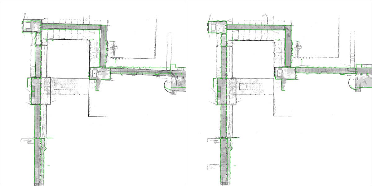
    The images below demonstrate the impact of NavVis Precision SLAM technology. The left image depicts a long corridor mapped with a conventional SLAM system where the above-mentioned drift error has occurred. The green outline shows how the map deviates from the true structure. The image on the right shows the significantly improved map accuracy obtained when mapping the same area using the M3 Trolley with the new Precision SLAM technology.

    Image: NavVis
    Image: NavVis

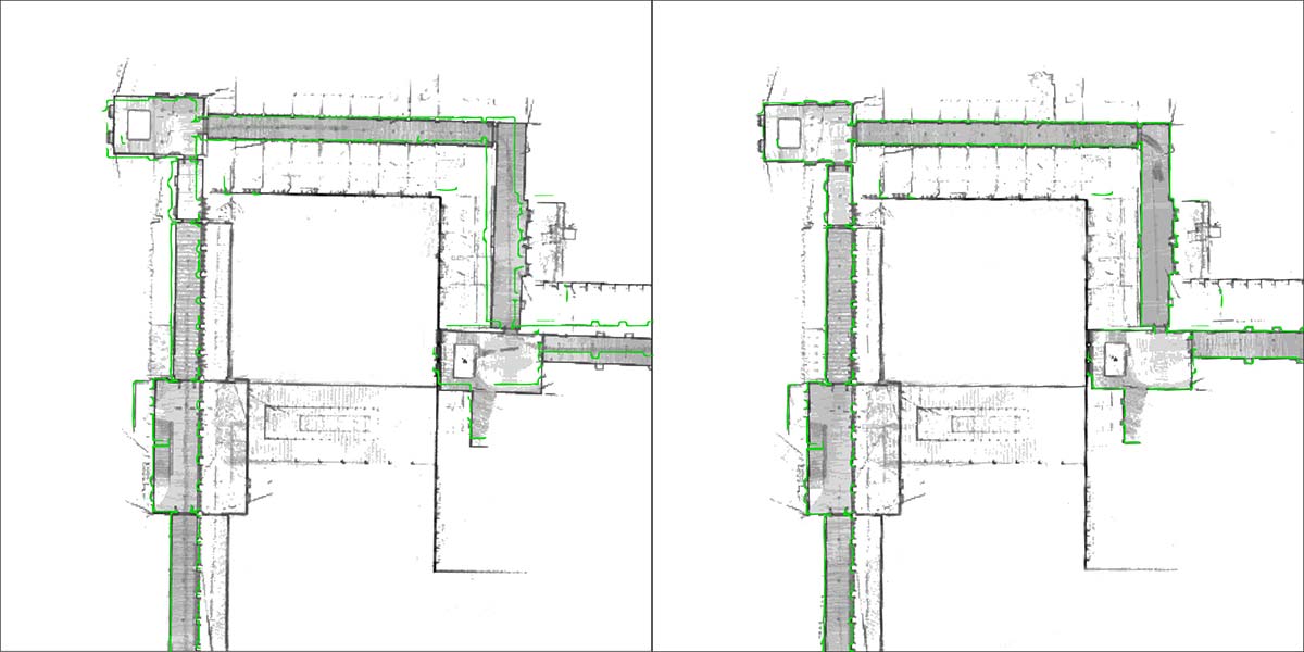
    Here is a closer look:

    Image: NavVis
    Image: NavVis

    SLAM is a technique originally developed by the robotics industry that is now increasingly being used in surveying and autonomous driving technologies. It solves a core problem that long plagued robotics engineers by enabling a device to determine its location while simultaneously mapping an unknown environment. This is done by chaining millions of measurements into a trajectory estimate.

    However, even when a device captures highly accurate individual measurements, chaining them will result in an accumulation of noise and tiny measurement uncertainties. Over time, the estimated motion will start to deviate from the true motion (drift error). This can often be observed as a slight bending of long corridors that are actually straight. All available SLAM systems — regardless of whether these use LIDARs or other sensors — are inherently affected by this phenomenon.

    The NavVis Precision SLAM technology significantly reduces drift error and improves the SLAM accuracy. This is particularly evident in cases where complementary techniques such as loop closures cannot be deployed, if, for example, the building’s layout does not allow for it.

    Precision SLAM even improves accuracy when SLAM anchors are used to incorporate ground control points into the mapping process.

    “I am very excited about our new Precision SLAM technology,” said Stefan Romberg, head of mapping and perception at NavVis. “We are always striving for the highest possible map and point-cloud accuracy and improving SLAM is a critical component to being successful. It is widely known among SLAM developers and users that complementary approaches such as loop closures or ground control points are needed to achieve a high accuracy.

    “However, with the Precision SLAM technology we have developed an approach that not only nicely complements the former techniques but is especially evident when these have little effect or cannot be used.”

  • ION names winners of 8th annual Autonomous Snowplow Competition

    ION names winners of 8th annual Autonomous Snowplow Competition

    The winner’s of ION’s 8th annual Autonomous Snowplow Competition was team “Snow Squirrel” from the University of Minnesota. Photo courtesy of ION.

    The Institute of Navigation’s (ION) Satellite Division held its 8th annual Autonomous Snowplow Competition Jan. 25-28 at Rice Park in St. Paul, Minnesota.

    The ION Autonomous Snowplow Competition, held in cooperation with the ION North Star Section, is an international event open to college and university students, as well as the general public. According to ION, the competition challenges teams to design, build and operate a fully autonomous snowplow using state-of-the-art navigation and control technologies.

    Eleven teams entered the competition, and eight of those teams successfully completed all the phases of the competition. Each team used a variety of navigation systems, including lira, optical navigation systems, inertial instruments, magnetic sensors, ultra wide-band radio reflectors, visual odometry, GNSS and differential GPS, to rapidly and accurately clear a designated path of snow.

    Teams were judged based upon their cumulative scores earned throughout the competition phases, including presentations and dynamic vehicle events.

    The first place team was the University of Minnesota’s “Snow Squirrel” team. The team was awarded $7,000 and a Golden Snow Globe Award, and is invited to present during the ION GNSS+ 2018 conference Sept. 24-38 in Miami. The second place team was the Dunwoody College of Technology’s “Wendigo 2018” team, which was awarded $4,000 and a Silver Snow Globe Award. Finally, the third place team was North Dakota State University’s “Thundar 3.0” team, which received $2,000 and a Bronze Snow Globe Award.

  • Next-generation EGNOS to combine Galileo, GPS for aviation

    Next-generation EGNOS to combine Galileo, GPS for aviation

    Satellite-based augmentation systems worldwide. (Image: ESA)

    News from the European Space Agency

    The next generation of Europe’s satellite navigation overlay service, EGNOS, will combine use of GPS and Galileo signals to improve accuracy and robustness of navigation for air traffic and other uses where lives are at stake.

    A contract was signed Jan. 26 at ESA’s technical centre in the Netherlands for the second  generation  of the European Geostationary Navigation Overlay Service, EGNOS V3, planned to enter service in 2025.

    ESA Director of Navigation Paul Verhoef signs the EGNOS V3 contract Jan. 26 with Senior Vice President of Airbus Defence and Space, Mathilde Royer Germain. (Photo: ESA)

    ESA Director of Navigation Paul Verhoef signed the contract with the senior vice president of Airbus Defence and Space, Mathilde Royer Germain,  in the presence of senior managers of the European Global Navigation Satellite System Agency (GSA) and of the European Commission.

    This improved version of the service will take advantage of in-operation Galileo signals as well as new frequencies from an improved class of GPS satellites. Use of the L5 second frequency will improve service robustness against errors and propagation delays caused by the ionosphere, an electrically active outer layer of Earth’s atmosphere.

    “This will be the first such regional satellite augmentation systems worldwide to employ dual frequency, GPS and Galileo signals,” comments Didier Flament, overseeing EGNOS development for ESA.

    For aircraft with the latest avionics, EGNOS V3 will be able to guide them accurately and safely down to Category 1, a 10 m Vertical Alert Limit (also called Cat1 Autoland capability), while also providing legacy users equipped with current avionics a more robust version of the current LPV200, or 35 m vertical limit vertical guidance service.

    As well as improving services for civil aviation, the plan is to introduce new services for other sectors such as maritime navigation and rail, and extend service coverage from the European continent to link up seamlessly with other interoperable augmentation systems worldwide.

    EGNOS is Europe’s other satellite navigation system, next to the global Galileo system.  Comparable to the US WAAS, the Wide Area Augmentation System, and other regional augmentation systems in the rest of the world, EGNOS is an overlay system based on a network of ground stations and transponders on geostationary satellites. These stations gather data on the current accuracy of US GPS signals and embed correction data in the EGNOS signal, which is uplinked via geostationary satellites to EGNOS users.

    The current EGNOS augments the accuracy of GPS signals across Europe and informs users of their current reliability level within six seconds. EGNOS belongs to a family of systems called Satellite Based Augmentation Systems (SBAS); the EGNOS V3 second generation will augment both GPS and Galileo.

    Designed against global standards set by the International Civil Aviation Organisation, EGNOS began offering its Open Service for non-safety-of-life uses in October 2009. In March 2011 its Safety-of-Life Service became available for aircraft navigation.

    Dozens of European airports are today employing EGNOS for vertical guidance approaches, as an economic alternative to ground-based infrastructure, like Instrument Landing Systems. It is estimated that that around 110 000 aircrafts worldwide are today equipped and using SBAS systems.

    The development of satellite-based augmentation systems around the world is being coordinated in particular by the international SBAS Interoperability Working Group, which last week held its 33rd meeting at ESA’s centre in Madrid, chaired by ESA and the US Federal Avigation Authority, joined by current or planned service providers from Africa, Australia, Canada, China, India, Japan, Russia and South Korea.

    Initiated by ESA in cooperation with the EU and Eurocontrol, the EGNOS Exploitation phase is managed by GSA and funded by the EU. ESA manages the EGNOS development under a working arrangement signed between GSA and ESA.

  • Danlaw releases through-glass integrated V2X antenna

    Danlaw Inc. has released its Through Glass Integrated V2X Antenna for vehicle-to-vehicle and vehicle-to-everything (V2X) communications.

    The design incorporates an integrated GNSS antenna on the interior coupler. Optional cellular, Wi-Fi, and other antennas are also available on request.

    The antenna pairs with dedicated short-range communications (DSRC) devices to enable vehicle-to-vehicle, and vehicle-to-infrastructure communications.

    Traditional aftermarket antennas require drilling holes or passing cables through window and door openings, which risks damaging vehicle seals.

    Danlaw’s dual-radio, glass-mounted antenna eliminates the risk of damaging the vehicle by using a coupling pair-to-pass DSRC signals between the vehicle’s interior and exterior.

    The easy-to-install antenna can be mounted on the rear, front or side windows using automotive grade glass adhesive. This flexible installation allows the shortest cable route to the V2X device, reducing signal losses due to cable length, the company said.

    “Our customers running pilot programs want to install V2X DSRC systems on vehicles with best-in-class RF performance without modifying their cars,” said Scott Morell, Danlaw’s vice president of engineering. “Combined with our Aftermarket V2X Safety Device, this enables V2X capabilities to be installed on vehicles simply and easily.”

    The antenna enhances Danlaw’s Connected Vehicle portfolio which includes an aftermarket safety device (ASD) and V2X development tools.

    The ASD has been selected by pilot programs supporting multiple applications, including critical safety advice, driver access solutions, and real-time road condition and congestion information.

    Danlaw development tools include the OmniAir-certified Mx-DSRC Conformance Test System and Mx-Drive Mobility Simulator.

    Detailed specifications for the antenna are available.

  • TomTom Autostream provides map delivery for autonomous driving

    TomTom has launched TomTom AutoStream, an innovative map delivery service for autonomous driving and advanced driver assistance systems. The first partners to use the technology — Baidu and Zenuity — were unveiled at the 2018 Consumer Electronics Show.

    TomTom AutoStream enables vehicles to build a horizon for the road ahead by streaming the latest map data from the TomTom cloud. By ensuring that the map used to power advanced driving functions is always the latest, TomTom AutoStream enhances driver comfort and safety.

    “The launch of TomTom AutoStream is a game-changer for OEMs and technology companies that are working on the future of driving,” said Willem Strijbosch, TomTom’s head of autonomous driving. “TomTom AutoStream allows vehicles to access the latest, most up-to-date TomTom map data for their driving automation functions.”

    TomTom AutoStream is designed in a flexible way, allowing customers to customize the map data stream based on criteria such as sensor configuration and horizon length. It can stream a wide variety of map data including ADAS attributes such as gradient and curvature, and the TomTom HD Map with RoadDNA. This flexibility allows customers to use AutoStream to power a wide range of driving automation functions.

    Strijbosch continued, “Our early investment in the TomTom advanced map-making platform means that we can continue to deliver revolutionary innovations like TomTom AutoStream. With TomTom AutoStream we can significantly simplify and shorten the development time for our customers, accelerating the future of driving.”

    TomTom AutoStream ensures that the TomTom map data used to power advanced driving functions is the latest, most accurate available, enabling a safer and more comfortable experience.

    “With AutoStream TomTom is offering an innovative map delivery system targeted at automated driving,” said Roger C. Lanctot, director, Automotive Connected Mobility for Strategy Analytics. “The development is targeted at helping automakers bring ADAS and autonomous driving functions to market faster.”

    TomTom AutoStream will be available for production usage in 2018.

  • Applanix offers Autonomy Development Platform for autonomous vehicles

    Applanix offers Autonomy Development Platform for autonomous vehicles

    Applanix, a Trimble Company, has introduced its Autonomy Development Platform to provide automakers, truck makers and Tier 1 vehicle suppliers the hardware, software, engineering and integration services they need to accelerate their development programs for on-road and off-road autonomous vehicles.

    By combining customized integration and engineering services along with Applanix’ GNSS-inertial positioning technologies, the Autonomy Development Platform advances driverless vehicle development projects at every stage of development and commercialization.

    “With the introduction of our Autonomy Development Platform, Applanix now offers on-road and off-road vehicle manufacturers the tools and engineering expertise necessary to support and augment their driverless vehicle development programs,” said Louis Nastro, director of Land Products at Applanix.

    “The platform delivers a navigation solution that is fully customizable and includes integration and engineering services, field-tested hardware and proprietary software for highly accurate positioning,” continued Nastro. “The navigation solution is capable of working with all sensors, including multiple cameras, lidar, radar and ultrasonic sensors, and with all vehicle types at all stages in the development and commercialization cycle.

    “The Applanix technology enables highly accurate assessments of the full 360-degree environment around a vehicle to produce a robust representation, including static and dynamic objects, critical for successful vehicle autonomy.”

    “Applanix has been committed to meeting the needs of autonomous vehicle manufacturers for more than a decade, going back to our success at the DARPA Challenges. In addition, our expertise in autonomous technologies is part of an extensive portfolio of Trimble solutions for automation and vehicle autonomy, which began more than three decades ago,” said Steve Woolven, president of Applanix. “Our refined positioning algorithms and expertise with sensor fusion and mobile robotic technologies enable us to provide a development platform that delivers the required performance and reliability for manufacturers to develop and produce self-driving vehicles for all environments and tasks.”

    The Applanix Autonomy Development Platform is available now through the Applanix worldwide sales channel.

    https://youtu.be/hF53U3MF_AE

  • Launchpad: Spoofer detection for surveyors

    OEM

    RF front-end board

    7-channel multi-GNSS multi-band for software-defined receiver

    The NT1065/66_USB3 multi-channel GNSS RF front-end board is based on NTLab’s RF ICs: NT1065 (four channels for GPS / GLONASS / Galileo / BeiDou / IRNSS / QZSS, L1/L2/L3/L5 bands) and new NT1066 (two channels for all previously mentioned GNSS signals, plus one extra-channel for IRNSS S-band). The board supports USB3 connection, allowing users to process captured satellite signals on a PC or DSP platform. The board is accompanied by comprehensive software and manuals. Features include six channels for L1/L2/L3/L5-band signals + one channel for S-band signals simultaneous reception; up to four coherent channels; IF bandwidth up to 32 MHz; acquisition of wideband signals up to 64 MHz (such as Galileo E5) by two coherent channels; USB3 interface (up to 800 Mbit/s); ability to connect four x CRPA. NTLab offers an academic discount program for universities, colleges and institutes, allowing them to purchase this powerful research tool with significant savings.

    NTLab, www.ntlab.com

    GNSS OEM RTK boards

    With rover radio for wireless applications

    Three new Tersus GNSS HRS kits feature high-precision BX305, BX306 and BX316 GNSS RTK boards. The kits consist of RTK receivers, GNSS antennas, RS05R radio station modems, radio station antennas, and related cables and converters. Embedded in the receivers are the Tersus RTK boards. They are compact-design, energy-efficient, centimeter-level accurate GNSS real-time kinematic (RTK) boards that bring high-precision positioning accuracy to the market. Different from the standard BX305/306/316 GNSS kits, the new HRS versions are equipped with the RS05R lightweight and robust UHF rover radio for wireless applications. It provides reliable data communication for demanding conditions that require a combination of stability, high performance and long-range operation. The kits can be used in a variety of applications, such as unmanned aerial vehicles (UAVs), surveying, mapping, precision agriculture, construction engineering and deformation monitoring.

    Tersus GNSS, www.tersus-gnss.com

    SURVEY & MAPPING

    Spoofer detection

    Spoofing alerts for surveyors

    Spoofer detection is now available on all JAVAD GNSS original equipment manufacturer (OEM) boards. When a receiver equipped with a JAVAD board detects more than one correlation peak for any PRN code, it warns the user of the presence of spoofing (false signals) and identifies the spoofed satellites. The receivers then switch to other signals and sensors that are not being spoofed to maintain accurate positioning. The user can also employ the receiver to try to identify the direction from which the spoofing signals are originating.

    JAVAD GNSS, www.javad.com

    Laser scanner

    Scanning range reaches 1 kilometer

    The ScanStation P50 combines all the features of the P40 plus a longer range scanning capability of more than 1 kilometer. The rugged, versatile laser scanner enables professionals to 3D capture at great distances with angular accuracy paired with low-range noise and survey-grade dual-axis compensation. The ScanStation P50 opens new business opportunities for reality-capture professionals, helping them to scan what was previously unreachable such as big mine pits, long bridges, dams and skyscrapers. With its range, the P50 enables users to scan any tall or wide infrastructure or dangerous sites from a remote and safe position. This newest member of the P-Series provides the highest quality 3D data and high-dynamic range (HDR) imaging at an extremely fast scan rate of up to 1 million points per second and ranges of more than 1 kilometer.

    Leica Geosystems, leica-geosystems.com

    TRANSPORTATION

    Smartphone data analysis

    Integrates gamification and real-time data

    Azuga FleetMobile: Standalone Smartphone Edition (SSE) is a smartphone-based solution for driver behavior monitoring, mobile timecard management and GPS tracking. Azuga FleetMobile SSE leverages data analysis components of the original Azuga FleetMobile application, including driver behavior monitoring, location-based timestamps for timecards, gamification and driver rewards, without requiring separate hardware installation via a vehicle’s OBD port. Azuga’s GPS fleet-tracking offerings feature a driver rewards program to help fleets reduce accidents by up to 70 percent. The standalone application, which works on both Android and iOS smartphones, integrates gamification and real-time data to encourage self-coaching and healthy competition. Azuga’s data science team can then leverage information about driving behaviors and combine them with route patterns, fleets’ vehicle health information and environmental factors to identify opportunities for performance improvements in fleet operations.

    Azuga, azuga.com

    Vehicle tracker

    Able to receive MobileEye ADAS alerts

    The RIFA series of full-featured GPS trackers have built-in gyro and G-sensors, and supports OBDII and J1939 protocols. In addition to 4G/3G communication, it provides options to use low-power wide-area networks (LPWAN) such as NB-IOT or LoRa, which can reduce communication costs significantly. The unique CAN-to-ADR (automotive dead reckoning) function provides accurate positioning in situations of weak GPS signals, such as driving in tunnels, indoor parking facilities, urban canyons or when GPS signal obstruction hinders positioning, without additional cabling for wheel speed input.

    Antzer Tech, www.antzer-tech.com

    UAV

    Thermal imaging payloads

    Ethernet/IP-Based connectivity

    The ThermalCapture IRnet provides an Ethernet interface for live data streaming to new and existing FLIR Tau 2 drone cores and FLIR Vue Pro/R cores. The market has increased its demand for connectivity by Ethernet, with professional drone manufacturers choosing Ethernet for communication on board UAVs. The ThermalCapture IRnet allows for real-time access via Ethernet while recording radiometric data to microSD, bringing real-time access in drone flight operations to thermal imaging data. It stores the full 14-bit radiometric thermal data on a microSD card. Real-time access remains available while radiometric data are being recorded; operators can also control the camera and settings via Ethernet. Using Ethernet also offers data privacy.

    TeAx, thermalcapture.com

    Airborne lidar mapping

    Centimeter-level accuracy for 3D mapping products

    The Think 3D Stormbee multicopter integrated with Trimble’s AP15 provides efficiency, accuracy and performance for lidar surveys from unmanned vehicles. The Stormbee is a directly georeferenced UAV lidar solution for 3D industrial mapping applications, designed to collect survey-grade spatial data more cost effectively and efficiently than static lidar. Stormbee’s 3D mapping technologies include Faro’s Focus 130 laser scanner, Trimble’s AP15 high-performance GNSS/inertial receiver, Applanix’s POSPac UAV GNSS/inertial post-processing software and Stormbee Beeflex software for lidar point-cloud generation. By using the high-performance Trimble AP15 with two antennas and the Applanix post-processing software (POSPac MMS) for georeferencing the lidar data, Stormbee provides an accurate real-time and post-mission solution for all motion variables.

    Think 3D, think3d.be

    Applanix, applanix.com

  • Helix Technologies to develop GNSS antennas for driverless cars

    Helix Technologies Ltd., a U.K.-based developer of high-performance, ceramic-based helix antennas, has secured funding that will enable continued development of antennas for a wide range of applications including autonomous vehicles, drones, internet of things and machine-to-machine communications.

    Photo: HelixAntenia
    Photo: HelixAntenia

    The company closed its Phase B funding round with GBP 650,000 of financing provided by private investors.

    The company said that the driverless car segment, both GNSS and vehicle-to-everything (V2X) dedicated short-range communications (DSRC) applications, represents the most immediate and compelling need and business opportunity for its helix antenna technology.

    Helix Technologies said its dielectric-loaded helix antennas will provide significant performance advantages over incumbent antenna technologies for next-generation GNSS and V2X applications.

    The use of a dielectric ceramic core gives its antennas unique properties including unsurpassed gain/efficiency per unit of volume and more effective and predictable behaviour in a wide range of challenging user scenarios.

    “We are grateful for the support of our investors which allows us to develop innovative solutions for this exciting growth market,” said John Yates, managing director of Helix Technologies. “The first self-driving cars are widely forecast to be on the market between 2019 and 2021. Any navigation and communications equipment used onboard will have to fulfil the highest-possible standards on safety, integrity and accuracy.”

    The company expects to have prototypes of its V2X DSRC antenna available by the second quarter of  2018 and its NEXTGEN GNSS antenna by the third quarter of 2018.

    According to the company, the use of the ceramic core enables the fabrication of antennas that are physically smaller than conventional antennas, behave much more effectively and predictably in a wide range of challenging user scenarios and have many compelling technical advantages which include:

    • Maintaining radiation efficiency near absorbing objects (such as the human body)
    • Improving the accuracy of GNSS systems in multipath environments (such as in cities)
    • Operation in sub-optimal orientations towards the sky
    • Are able to be placed into very tightly integrated systems
    • Operation in slim devices without a ground plane
    • Unsurpassed gain/efficiency per unit of volume
    • Simple and robust design and construction for durability and reliability
    • Excellent beamwidth (omni-directionality)
    • Multi-frequency, tailored frequency response
  • u-blox automotive-grade GNSS module features extended operating temperatures

    u-blox automotive-grade GNSS module features extended operating temperatures

    u‑blox is offering the automotive-grade MAX‑M8Q‑01A GNSS module, which measures 9.7 x 10.1 x 2.5 millimeters and has an operating temperature range from –40 degrees Celsius to 105 degrees Celsius.

    The MAX‑M8Q is the company’s third automotive-grade GNSS module to date, alongside the NEO‑M8Q‑01A and NEO‑M8L‑03A modules.

    MAX‑M8Q‑01A is designed to meet the stringent requirements of the automotive market, providing superior positioning accuracy even in challenging environments such as urban canyons. Its extended temperature range ensures reliable performance even in harsh environments, e.g. when mounted in a car‑roof antenna.

    Produced in adherence to the u‑blox 0 ppm program, which aims to bring down product failures rates to zero and consistently achieve high production quality, the module is delivered with the automotive industry’s standard PPAP documentation to ensure compliance with customer requirements.

    The module offers product developers a reduction of design and qualification time and effort, shortening time‑to‑market and considerably reducing risks for new product development.

    “We developed this automotive grade GNSS module in the small MAX form factor in response to customer requests for a GNSS receiver that operates reliably in an extended temperature range,” said Franck Berny, senior principal, automotive market development, u-blox. “We are confident that the module’s high quality, robust and secure performance, and small form factor will appeal to the automotive industry at large.”

  • Qualcomm Automotive Solutions chosen by Jaguar, Honda, more

    Qualcomm Automotive Solutions chosen by Jaguar, Honda, more

    Qualcomm Technologies Inc., a subsidiary of Qualcomm Incorporated, announced several automotive agreements at the Consumer Electronics Show (CES) 2018, at North Hall Booth 5616. The show took place Jan. 9-12 in Las Vegas.

    As the automotive industry advances toward 5G, highly advanced connectivity solutions are needed to support road safety, mission critical applications, as well as advanced capabilities, such as autonomy.

    With the Qualcomm Snapdragon automotive platform’s integrated GNSS and automotive dead reckoning, future vehicles are expected to have the increased capability to effectively be aware of its surroundings.

    2017 Jaguar Land Rover. (Photo: Jaguar)
    2017 Jaguar Land Rover. (Photo: Jaguar)

    Jaguar Land Rover. Jaguar will use the Qualcomm Snapdragon automotive platform in the Land Rover to power highly advanced telematics, infotainment and digital cluster with integrated connectivity and rear-seat entertainment. The platform will help meet the demand for rich, immersive and seamless connected in-vehicle experiences in future Jaguar Land Rover vehicles.

    For telematics units, Jaguar Land Rover will use the Snapdragon 820Am automotive platform to provide customers with ultra-quick and efficient connectivity throughout the vehicle by integrating 4G LTE Advanced, Wi-Fi and Bluetooth technologies.

    As Qualcomm Technologies’ most advanced automotive solution, the Snapdragon 820Am Automotive platform features a custom-built 64-bit Qualcomm Kryo  CPU, custom-built Qualcomm Adreno 530 GPU for virtualization advantages, and Qualcomm Hexagon 680 DSP Vector eXtension to stream high-definition videos seamlessly onto multiple displays.

    It also features the Snapdragon X12 LTE modem to support Category 12 speeds up to 600 Mbps download, as well as vehicle sensor integration and computer vision to support driver assistance using the Snapdragon Neural Processing Engine.

    2018 Honda Accord. The 2018 Honda Accord features the Snapdragon Automotive Platform to power applications for its in-vehicle infotainment and navigation system. The 2018 Honda Accord also features a Qualcomm 4G LTE modem designed to support the Hondalink vehicle connectivity system. 

    BYD Electric Vehicles. Chinese new energy company BYD Company Ltd. also selected Qualcomm Technologies’ automotive solutions for its upcoming electric vehicles. Anticipated to begin in 2019, BYD electric vehicles will feature integrated infotainment and digital cluster systems powered by the Qualcomm Snapdragon 820A Automotive platform.

    The software architecture, hypervisor support and integration capability of the 820A supports BYD’s efforts to integrate its infotainment and digital cluster systems into a single electronic control unit (ECU). This is designed to deliver significant optimization and integration benefits compared to previous architectures, which used several different ECUs within the vehicle.

    Qualcomm Technologies’ automotive solutions help improve power efficiency within the integrated ECU, which aids in enhancing the vehicle overall performance, battery life and driving range. The use of Qualcomm Technologies’ integrated infotainment and cluster system with Snapdragon 820A Automotive platform is designed to support a unified user interface, improvement in contextual awareness, and a rich in-vehicle user experience with multimedia.

    Visteon Cockpit. Visteon Corporation plans to deliver the next-generation of its SmartCore cockpit controllers using automotive solutions from Qualcomm.

    Future SmartCore cockpit controllers will feature the Qualcomm Snapdragon 820A Automotive platform to support automakers’ demand for highly advanced virtual cockpit controllers, which Visteon will design to support autonomous driving technology and applications.

    Visteon’s SmartCore domain controller, which can independently operate several cockpit domains on one system-on-a-chip (SoC) through a single driver interface, will be the first platform-based domain controller to incorporate the Snapdragon 820A Automotive platform.

    Using Snapdragon automotive solutions from Qualcomm Technologies, Visteon aims to make available technologies to support advanced virtual cockpits and autonomous driving through Visteon’s scalable hardware and software stack in SmartCore and its DriveCore  autonomous driving controller.

    DriveCore is an open platform consisting of the hardware, middleware and frameworks to develop machine learning algorithms for object classification, detection, path planning and execution.

    Visteon is scheduled to launch the first SmartCore-based solution in 2018 on a high-volume, global vehicle platform with a European automaker.

  • Fleets go green — and get green — with GPS

    By Jason Penkethman, Chief Product Officer at Spireon

    Fleets looking to take their operations to the next level look to GPS solutions for the obvious benefits — driver/vehicle location tracking, driver behavior monitoring, improved efficiency — and some that are not so obvious, such as making a positive impact on the environment.

    “Going green” can be an arduous task, requiring constant calculations and adjustments to ensure that a fleet’s reduced environmental impact doesn’t negatively affect normal operations.

    Fortunately, GPS fleet management solutions have come a long way and go far beyond simple geolocation. We live in an age where technology empowers fleet managers to go green – both environmentally and fiscally. And with effective communication and transparency, even drivers who once may have perceived fleet tracking as “big brother” are now seeing how joining the green initiative puts green in their own pockets.

    The Case for Smarter, Eco-friendly Workdays

    No matter the size of the fleet, reducing unnecessary drive time saves time, gas, and reduces carbon footprint. When last minute changes or emergencies arise, fleet tracking allows managers to dispatch the nearest driver for faster, more effective resolution. Fleet tracking also allows better planning of a driver’s day with proximity as a guide.

    Image: Spireon
    Image: Spireon

    Eliminating Paper Waste. To properly manage a fleet, there is a seemingly endless stream of logs and diagnostics for drivers, cargo, vehicles and more. Implementing GPS tracking will cut back on the paperwork for managers and drivers alike by automating what once were manual processes and making compliance with new federal regulations such as the ELD mandate and the Food Safety Modernization Act a breeze.

    Cutting Unnecessary Emissions. Idling and abrupt acceleration or braking are the biggest culprits of wasting gas and producing excess emissions. Thanks to GPS logging, these can be avoided as feedback is provided to fleet managers and drivers, allowing active awareness for better driving habits.

    Better Maintenance, Better Mileage. Second to employees, vehicles are a fleet’s most important asset, and both need proper attention and care to succeed! While drivers can tell a fleet manager what they need, many vehicles won’t until it’s too late. With modern GPS devices, diagnostics are constantly run, keeping fleets informed and instantly aware of upcoming maintenance or surprises to keep drivers safe and vehicles running at maximum efficiency.

    Creating Driver Advocates

    While the benefits of GPS fleet tracking seem clear, overcoming driver apprehension sometimes causes pause for the business owner looking to implement a solution.

    However, drivers can become GPS’ greatest advocates with clear communication and transparency. It’s important to explain that GPS tracking works to a driver’s advantage when there are records of driver performance in the event of an accident, medical emergency or crime.

    Fleet managers can use the data to support drivers if they are accused of wrongdoing by customers or an insurance company. Additionally, the system can be used to offer incentives including higher base pay, recognition or bonuses to the best performing drivers.

    Fleets should convey that the main goal of GPS is not to point fingers at drivers or to spy on them, but rather to make the business enterprise more efficient and competitive.

    Part of the process necessarily means an overall improvement in their working conditions such as not having to call them all the time to keep track of their positions, sending the closest convenient driver to a location, establishing routes and schedules that are manageable and — yes — monitoring their behavior.

    This, however, is an incentive to keep drivers under the speed limit and make them feel more responsible — not least, protecting against legal and safety issues. In our experience, good employees have no problem with accountability and, in fact, welcome it as it sets them apart from less productive co-workers.

    Greenery on the Scenery

    Fleet tracking also helps to explain the savings in company costs made on fuel, maintenance and administration jobs.

    Fleet managers should explain to drivers how the new process can generate bonus programs, reduce customer call-backs, cancellations, complaints and paperwork (for timecards) and improve upon driver training.

    GPS will make for a better company with benefits everyone should realize and readily appreciate. The healthier the company, the more secure the jobs within it. Everyone benefits from a fatter bottom line, and job security is nonexistent without profitability. Helping drivers to understand why the fleet is adopting the solution will help recruit them toward a positive outcome.

    Whether a fleet business is interested in going green for the environment, or for its own profitability, GPS tracking solutions — and gaining driver buy-in — create a powerful catapult to achieving goals rapidly and effectively.


    Jason Penkethman is chief product officer at Spireon and is responsible for leading innovation in the company’s products and platform, and creating vehicle connectivity solutions to maximize customer value.

  • NovAtel technology showcased at CES 2018 with Renesas Electronics

    NovAtel technology showcased at CES 2018 with Renesas Electronics

    NovAtel technology will be on display at Consumer Electronics Show (CES) Jan. 9-12 in Las Vegas with Renesas Electronics Corporation.

    Renesas will use NovAtel’s high-performance SPAN tightly coupled GNSS and inertial navigation system (INS) technologies with GNSS correction services for live autonomous vehicles and advanced driver assistance systems (ADAS) demonstrations throughout CES.

    SPAN GNSS+INS products provide position, orientation and time solutions that are critical for autonomous applications.

    NovAtel’s assured positioning technology not only delivers solutions based on signals from satellite constellations but also uses vehicle behavior modelling, inertial sensor integration and GNSS correction signals to improve accuracy and significantly reduce interruptions in availability.

    Image: NovAtel
    Image: NovAtel

    Renesas relies on NovAtel products to provide high integrity and accurate positioning for autonomous driving, ADAS, connected car feature demonstrations and automotive solutions that will be showcased at CES 2018.

    With the commitment to ensure autonomous vehicles have assured positioning solution, a team of engineers formed the Safety Critical Systems Group at NovAtel to meet the exceptional performance and safety requirements of autonomous vehicles at the necessary production volumes and price point required.

    Since its formation, the group has made many positive partnerships in the automotive industry.

    NovAtel and Renesas are currently collaborating on implementing NovAtel’s high-performance GNSS+INS positioning solution with the Renesas R-Car H3 system-on-chip (SoC). The R-Car H3 is compliant with the ISO 26262 functional safety standard for automotive applications, which aligns with NovAtel’s automotive strategy.

    NovAtel has a long history providing industry leading high-precision GNSS solutions that are high quality and reliable. As an ISO 9001 certified company, NovAtel is also developing an extensive product line of receivers, antennas, correction signals, positioning algorithms, sensor fusion solutions and systems that fulfill specific safety requirements of the automotive industry such as ISO 26262.