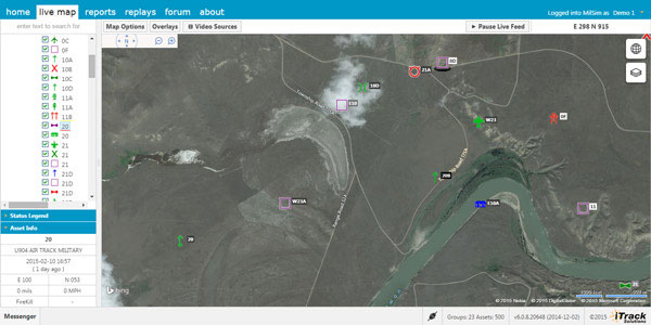
Integrated Tracking (iTrack) Solutions Loki Gen 6 is a web-based mapping software derived from a series of other Loki software products focused on asset tracking for large fleets of vehicles.
The maps are provided by Bing, but custom mapping can also be used with the support of Esri ArcGIS REST services and shapefiles.
iTrack Solutions is based in Calgary, Canada, and provides GPS tracking, mobile data communications and display software. The Loki Gen 6 features are listed below.
Home Home is a configurable dashboard showing plans, schedules, calendars and other details.
Live View Live View shows the live BING map from anywhere in the world, which includes maps, satellite and aerial imagery as well as maps provided by the user. Video streams are supported, and a 3D viewing feature is provided from Cesium. A user can add or draw features on the map to share with other users.
Photo: Integrated Tracking Solutions
Communication With this feature, users can communicate one-to-one or through a chat room, which includes video chat functionality.
Management An administrative user can assign tracking devices to vehicles, assign vehicles to subgroups, assign subgroups to larger groups or drivers to vehicles. An administrator also can set privileges for individual users.
Access to data Users can generate and view a replay on the fly as well as generate reports for vehicle tracking, hours in service, mileage, stop location and speed.
Observations, Analysis The forum feature provides a place group discussion, which becomes part of the Loki database, is searchable and can be linked to reports and replays.
A contract between the Congolese Ministry of Roads and Public Works and IGN France International for a preliminary study on updating the country’s existing roadways database was signed on Jan. 12 at the Congolese Embassy in France.
Once this database is fully operational it will be used as a decision-making tool for the Ministry and various institutions in charge of road network maintenance, as well enabling the management of Congo’s road heritage.
IGN France International will carry out a preliminary study for the Ministry, which aims to update the existing roadways database for the whole of the country.
Among those present at the signing of the contact was a large Congolese delegation led by the Ministry of Roads and Public Works Minister, Emile Ouosso.
This project is the next phase of an overall program of large-scale works undertaken by the Congolese government since 2009, which have already included the extension and improvement of the country’s road network, which no longer resembles the map created by IGN — French National Institute for Geographic and Forest Information — in 1993.
The preliminary study will define:
the expected functionalities of the future database;
the status of reference data;
the status of various “trades;”
the general organization to be implemented for the effective update of the database;
the equipment required for data acquisition, treatment and conservation;
and the knowledge transfer to be provided in order that work can be carried out locally.
This database will constitute a road heritage management and decision-making tool for the Ministry.
At present, the National Transport program (PNT) adopted by the Parliament of Congo in 2007 remains the general framework governing the actions to be taken in terms of the construction, rehabilitation or maintenance work on roadway infrastructures includes in the societal program created by the President of the Republic.
Fugro has introduced its high-accuracy G2+ service, designed to benefit offshore operators around the globe who require positioning and measurement accuracy at centimeter level.
G2+ is an enhancement of Fugro’s G2 service (based on GPS and GLONASS). The service uses highly advanced GNSS augmentation algorithms developed in house. The code and carrier-phase signals transmitted by GPS and GLONASS satellites are monitored globally by Fugro’s worldwide network of reference stations.
These observations are processed centrally in real-time using the company’s proprietary algorithms to generate precise corrections which are used to augment the standard signals broadcast by GPS and GLONASS satellites.
Customers receive corrections via seven high-powered communications satellites, providing at least two independent G2+ data sources. The new satellite positioning service will be particularly beneficial when seeking to measure latitude, longitude, elevation and speed with high accuracy in real-time, Fugro said.
Applications include offshore construction, survey services, vessel monitoring and structural monitoring. The ultra-high accuracy enables the real-time correction of tidal changes — which impact the accuracy of seabed mapping — as well as the real-time monitoring of the motion of floating and fixed structures.
The 3D accuracies of the system approach those of GNSS RTK (real-time kinematic) systems while avoiding the need for an RTK base station or local transmission link, overcoming the logistical challenges and range limitations associated with coastal RTK systems, Fugro said.
The launch of G2+ follows the recent launch of Fugro’s G4 satellite correction service, which takes advantage of all four global navigation satellite systems: GPS, GLONASS, BeiDou and Galileo.
SAFIR is part of the Africa-EU long-term strategic partnership to enhance safety in air transport. Its global objective is to build capacity within African ACP countries for the future deployment of GNSS/EGNOS in the region. The three-year project is funded by the European Union and financed from the 10th EDF Intra ACP envelope with 3.7 million euros, under an international consortium led by ASECNA (Agence pour la Sécurité de la Navigation Aérienne en Afrique et à Madagascar) with Egis, Pildo Labs and ESSP.
The ceremony took place in Dakar on March 3. Those attending included Matthias Petschke, EU Satellite Navigation Programmes director; Karolina Stasiak from the UE Delegation in Sénégal; and Amadou Ousmane Guittèye, director general of ASECNA.
“Satellite navigation can bring huge societal benefits, be it in transport, in agriculture or land management,” Petschke said in remarks at the launch ceremony. “Satellite-based augmentation systems in particular, like EGNOS, can bring enormous social and economic benefits. I attach, therefore, great importance to the setting up of the EGNOS Africa Joint Programme Office and am particularly pleased to see this team of African experts who have extensive experience and knowledge to support the development of an African satellite based augmentation system.”
In his speech, Guittèye said, “The first mission of the JPO is to ensure Africa has developed adequate competencies and then to coordinate the implementation of the development and of the deployment of GNSS/EGNOS services and applications in the continent. The EGNOS-Africa Joint Programme Office (JPO) is a pan-African entity that acts for the benefit of Africa and supports stakeholders in their GNSS/EGNOS strategy, developments and implementation.”
The ceremony also was attended by officials from the International Civil Aviation Organisation (ICAO), the African Civil Aviation Commission (AFCAC), the Agence Nationale de l’Aviation Civile et de la Météorologie (ANACIM) , the Aéroports du Sénégal (ADS) and local authorities.
The SAFIR project began on January 15, 2013. It covers the set-up, staffing and operations of an EGNOS-Africa Joint Programme Office, and sets up and supports a number of technical working sessions composed of regional stakeholders concerned with GNSS/EGNOS in sub-Saharan Africa.
ASECNA has 18 member states. With air navigation safety as its main mission, it cooperatively manages African airspace for the countries of Benin, Burkina Faso, Cameroun, Central African Republic, Comoros, Congo, Côte d’Ivoire, France, Gabon, Guinea Bissau, Equatorial Guinea , Madagascar, Mali, Mauritania, Niger, Senegal, Chad and Togo.
Esri and RouteSmart Technologies, Inc., are collaborating to help postal organizations deliver packages reliably, efficiently, and accurately. The companies provide comprehensive dynamic routing solutions based on Esri’s ArcGIS platform.
National postal and global and regional parcel delivery services, including Whistl, Posti, and Swiss Post, are among the customers that leverage these routing solutions. Most customers have experienced cost savings of 15 percent, on average, through reduced working hours, mileage, and new vehicle acquisition. Customers also report growth opportunities through opening new lines of distribution business to support the burgeoning e-commerce delivery segment.
“By integrating location-based analysis with a postal organization’s traditional business systems, such as sorting machines and address management systems, we are solving territory planning and route management challenges these organizations are facing,” said Chris Walz, vice president of sales and marketing for RouteSmart Technologies. “With our help, they can align to the new realities of postal and parcel distribution economics brought on through the growth of e-commerce shipping volumes and declining letter volumes.”
Esri and RouteSmart will share how they are helping postal organizations continue to be drivers of innovation in transportation and operational efficiencies at the European Post and Parcel Services Conference in Vienna, Austria, March 24–26.
“One of the biggest upcoming challenges for the postal industry will be the adoption of fully automated vehicles for deliveries,” Hall said. “With our partner RouteSmart, we provide a path for migration with the help of advanced location intelligence, optimization, and analysis tools.”
In the report, the analysts have identified and deciphered the market dynamics in important GNSS industry segments, highlighting the areas offering promising possibilities for companies to boost their growth, according to Research and Markets. The report studies the market by sectors including location-based services (LBS), transportation (further divided into road navigation, rail navigation, air navigation and marine navigation), surveying and agriculture. The GNSS application market is further studied by region: North America, Europe, Asia-Pacific, and Rest of World.
The report provides a complete overview of the GNSS market globally. All the current trends and drivers, coupled with potential growth areas of the GNSS industry, have been evaluated in the report. Furthermore, the report provides information on opportunities in the industry for different companies in the chapter titled Opportunity Assessment.
Additionally, to provide an exhaustive knowledge of the prospects for GNSS players on the geographical front, the report provides comprehensive knowledge of the 10 most worthwhile GNSS markets around the world (U.S., Canada, UK, France, Germany, Russia, Japan, China, South Korea and India). It includes information about the present state and future outlook of the LBS and telematics markets in these countries along with information about their personal navigation systems such as GPS, BeiDou,Galileo, GLONASS, QZSS and IRNSS.
The report also looks into the competitive landscape covering business overviews, key financials, product analyses, recent developments and strengths and weaknesses of each of the players.
Key trends considered in the report include:
Driverless Car: New GNSS Technology Use
Indoor GNSS Positioning Poised for Growth
People, Pets and Thing Finder: The Next Attraction
GNSS Based Products: A Burgeoning Market Opportunity
Tallysman Wireless has released a hosted data service for its TruFleet AVL (Automatic Vehicle Location) system, which runs on MOTOTRBO digital two-way radio networks. The new service enables Tallysman’s channel partners to build and brand their own carrier network of individual radio systems and to generate an ongoing revenue stream using any MOTOTRBO radio configuration, from conventional repeaters though to wide area trunking systems.
TruFleet is a web browser interface for Tallysman’s fleet management AVL application that enables clear fleet overview and management. It delivers excellent web-based reporting capabilities, is very reliable, and has a rich, intuitive interface that is simple to master and to operate.
The new TruFleet hosted data service enables channel partners to offer a cost-effective AVL solution for fleet sizes with as few as 15 subscribers.
“The TruFleet solution generates compressed batched messages transmitted at a low reporting rate, similar to first generation Tallysman Sprite devices, but a patent-pending algorithm provides much greater data compression, conserving data bandwidth,” said John Seymour, director of data systems at Tallysman. “This enables us to to provide precise positioning at rates that are competitive with cellular systems.”
Veripos, a supplier of high-precision GNSS positioning facilities to offshore and associated industries, has upgraded its Apex and Apex² precise point positioning (PPP) services.
The services now typically provide users with a horizontal position accuracy of better than 5 cm and 12 cm in the vertical at the two sigma (95 percent) confidence level.
The enhanced levels of performance, now available to all current users of Apex and Apex² without any need to upgrade, have been calculated from static data obtained in Aberdeen, Scotland, where Veripos is headquartered, as well as Houston, Texas, and Singapore. Veripos said that accuracies may vary with observing conditions, however.
The improved accuracy follows a major upgrade of the entire Veripos global reference station network for tracking all GNSS signals, together with introduction of new receivers and geodetic antennas for delivery of better measurement quality resulting from refinements to algorithms and software used to derive necessary GNSS orbit and clock corrections.
Designed to meet all offshore positioning and navigation applications, the dual-beam Apex and Apex² PPP services are relayed via seven geostationary communications satellites to ensure continuous availability and service redundancy while providing access to both GPS and GLONASS constellations. Positional accuracy is maintained regardless of user location, Veripos said.
Rohde & Schwarz adds ERA GLONASS to its reliable test solution for in vehicle emergency call systems. Photo: Rohde & Schwarz
Effective January 1, 2015, all new car models introduced to the Russian market must be equipped with the automatic ERA-GLONASS emergency call system. Rohde & Schwarz now offers a standard compliant test solution for manufacturers and suppliers of these in-vehicle systems.
Rohde & Schwarz is demonstrating its ERA-GLONASS test setup at Mobile World Congress, being held this week in Barcelona, Spain.
The test setup consists of the R&S CMW500 wideband radio communication tester and R&S SMBV100A vector signal generator as a GNSS simulator. This setup allows manufacturers and suppliers of automatic in-vehicle systems (IVS) to perform reliable and reproducible pre-conformance tests on their ERA-GLONASS modules in the lab.
In the Russian Federation, ERA-GLONASS works much like the European Union’s eCall system. When an accident occurs, the IVS connects with a public safety answering point (PSAP) via the local wireless communications network and transmits a standardized minimum set of data (MSD). In addition to GLONASS or GPS coordinates, the MSD also contains data with information about the accident vehicle as specified in ERA-GLONASS. If no voice connection can be made or if data cannot be transferred via the voice channel, the MSD is sent to the PSAP via SMS. This fallback option is a special ERA-GLONASS feature. The Russian system is also certified for 2G and WCDMA networks.
Rohde & Schwarz developed its R&S CMW-KA095 application software to meet ERA-GLONASS requirements in line with Russia’s GOST specification. Based on the R&S CMW-KA094 eCall software, the R&S CMW-KA095 simulates a PSAP and controls the R&S CMW500 emulating a wireless communications network in the lab. The software also controls the GNSS simulator that supplies the coordinates required for vehicle localization. With this solution, users can verify whether their IVS modem is able to successfully initiate an emergency call, transmit the correct MSD and establish a voice connection with a PSAP. The results are interpreted in line with the GOST specification.
The ERA-GLONASS SMS protocol has also been integrated into the test solution, making it possible to test the SMS functionality of the IVS modem when no voice connection is available.
The test solution is fully automated because of the R&S CMWrun sequencer software. The R&S CMW-KT110 eCall/ERA-GLONASS test package provides a user-friendly, automated functional test in line with GOST55330, enabling users to verify the operability of an entire system in the lab and document it in a report.
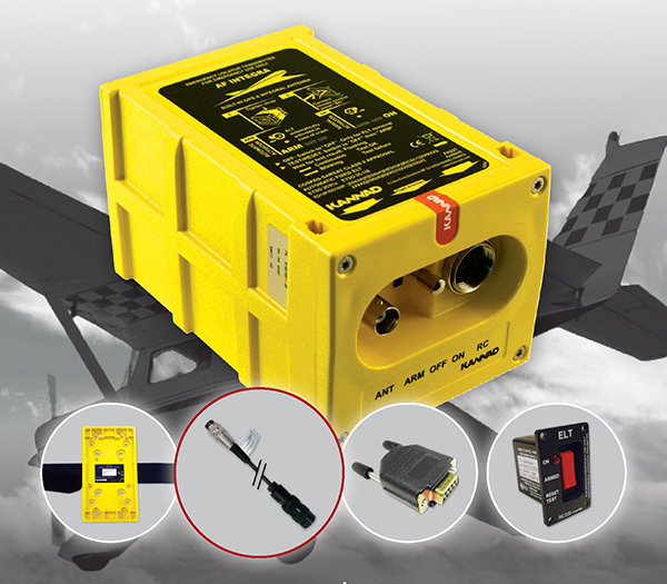
The The Kannad Integra Smart Pack by McMurdo Group could make it twice as easy to find missing aircraft. Photo: McMurdo Group
McMurdo Group, maker of end-to-end search and rescue solutions, has launched the Kannad Integra Smart Pack, an aviation emergency locator transmitter (ELT) bundle with both GPS and antenna redundancy. The product can result in Integra Smart Pack-equipped aircraft being twice as likely to be found in the event of an emergency compared to standard ELTs.
The Kannad Integra Smart Pack includes:
The Kannad Integra ELT – a small, light ELT with a built-in antenna and embedded GPS receiver.
The new Kannad Integra e-NAV NMEA – an NMEA-standard interface cable that connects the Integra ELT to the aircraft GPS. The latest known aircraft GPS position is continually updated and stored on the interface cable itself to provide an additional level of redundancy over the embedded Integra ELT GPS data.
Traditional ELTs rely on an aircraft’s external antenna and GPS equipment, which is subject to failure in the event of an emergency. The Integra ELT, however, can operate independently of the aircraft to provide key positioning data through its internal antenna and GPS receiver.
With the Integra Smart Pack bundle, in the event that the Integra ELT’s internal GPS antenna is unsuccessful for any reason, the positioning coordinates from the Integra e-NAV NMEA will be used. This additional GPS redundancy will result in better location positioning and higher chance of rescue.
“McMurdo is delighted to continue its long history of aviation search and rescue innovation with the introduction of the Kannad Integra Smart Pack,” said Christian Belleux, head of McMurdo’s Kannad Aviation Business Unit. “The Integra Smart Pack is a must-have SAR [search-and-rescue] solution to help ensure accelerated rescue response in the event of an emergency and to ultimately save more lives.”
The Integra ELT Smart Pack is suitable for all types of aircraft with specific versions to support helicopters, general aviation planes and large commercial jets. Once activated, the Integra ELT transmits a distress signal to alert international rescue services to the emergency location via the global Cospas-Sarsat Search and Rescue satellite system, which has helped to save more than 37,000 lives since 1982.
The McMurdo Group is exhibiting this week at Heli Expo 2015, Booth 5465, in Orlando, Fla.
Geotab, a telematics engineering company, has released its IOX-CAN extender, a plug-and-play solution that allows partners to send data from their device over a private CAN network in the vehicle, supporting integrations on all vehicle types.
Geotab is exhibiting at Mobile World Congress 2015, at Hall 3, Stand 3J20.
According to Geotab, Fortune 500 companies, including 40 percent of the top ten fleets and 18 percent of the top 100 fleets in North America, rely on Geotab’s solutions to improve productivity, optimize fleets through the reduction of fuel consumption, enhance driver safety, and achieve stronger compliance to regulatory changes.
A number of companies are already leveraging the IOX-CAN extender to send data from their devices to the MyGeotab system. Geotab’s integration with Mobileye, a technology company that develops vision-based Advanced Driver Assistance Systems (ADAS) providing warnings for collision prevention and mitigation, has been upgraded with the IOX-CAN extender allowing full support for all vehicle types, including OBDII (on-board diagnostics II) vehicles.
Geotab’s new add-on solution allows Mobileye devices to plug into Geotab’s GO6 and GO7 devices, allowing Mobileye data to be sent to the MyGeotab software platform, where it can be viewed and analyzed by dispatchers and fleet managers.
“Our solutions are designed to make the roads safer for everyone as the issue of distracted driving continues to be a problem,” said Elad Serfaty, vice president and general manager of Mobileye Aftermarket. “Working with Geotab allows us to not only provide feedback to the driver, and with managers who can effect change where needed, but we can do this across all vehicle types.”
“Expanding our integration capabilities and continuing our work with Mobileye is a natural evolution as more and more companies realize the benefits of fleet management,” said Neil Cawse, CEO, Geotab. “Providing collision warnings to drivers just before a crash is the first step to creating a safer driving environment for everyone.”
Editor’s note: Dennehy is GPS World’s editor for location-based services, writing a monthly column for the LBS Insider newsletter. The views expressed are his own. He will be covering the Mobile World Congress in Barcelona for GPS World. Contact him at [email protected] with your news.
Sen. Ed Markey’s new car technology report, released earlier this month, basically says that connected vehicles can be hacked, causing danger to drivers and presenting major privacy concerns. While some critics believe Markey’s report was meant to drive media hysteria, others say it raises serious issues that the industry needs to address. In other location news, I’ll be covering the Mobile World Congress in Barcelona for GPS World. What will be the showcased location technology? Wearables? Connected vehicles? Or something new?
Kevin Dennehy
By Kevin Dennehy
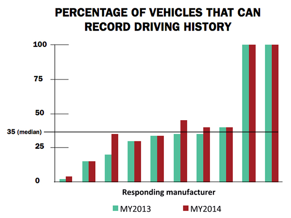
A report released by Sen. Edward Markey (D-Mass.) earlier this month says that even though drivers have come to rely on new connected technologies, automakers haven’t done their part to protect them from cyber attacks or privacy invasions
First reported by CBS News’ 60 Minutes, Markey’s report, Tracking & Hacking: Security & Privacy Gaps Put American Drivers at Risk, includes information from 16 automobile manufacturers who were given questions about security and privacy. However, few of the carmakers’ answers included how vehicles may be vulnerable to hackers — and what driver information is collected.
Location industry veteran Kim Fennell, deCarta CEO, said the report should be a real concern to the industry. “But it’s more of an issue for autonomous driving and the security of the car’s electronic control system. Even today, the OnStar service, which was a pioneer in the connected car space, can remotely slow your vehicle down in the event of a theft,” he said. “This feature, if hacked, could definitely create massive problems if the proper security technologies are not implemented.”
Markey’s report raised additional concerns about the use of navigation and other features that record and send location or driving history information.
Fennell said there should be a distinction between the infotainment systems in the vehicle and the on-board control systems of the car.
“We believe that there should be a strict firewall between these systems so that nothing malicious can happen that is initiated from the connected infotainment system. Any data should flow one way — from the control system of the car to the infotainment system,” he said. “This is not to say that the connected infotainment system shouldn’t be secure, it should be. In working with our OEM and Tier One partners, we have implemented strict security protocols between our servers and their apps.”
Markey’s report found that “[automakers] use personal vehicle data in various ways, often vaguely to ‘improve the customer experience’ and usually involving third parties, and retention policies — how long they store information about drivers — vary considerably among manufacturers.”
In addition, the report found that customers are often not made aware of data collection and, when they are, they often cannot opt out without disabling features, such as navigation.
Percentage of Vehicles that can record driving history
Overall, Fennell hopes that the most malicious thing that could happen in the event of a hack of an infotainment system is that a “Pandora station is changed to play nothing but Justin Bieber songs, the traffic information for your route is projected to be ridiculously long or the Yelp rating of the restaurant that you are going to is lowered down to one star.”
Ultimately though, the driver should be in control of the car and nothing in the infotainment system should affect the behavior of the vehicle, Fennell said.
In terms of driver safety, in a recent survey, deCarta found that more than two-thirds of respondents considered dashboard screens that display videos and other Internet content to be the most dangerous types of onboard information systems. Approximately 79 percent of those polled preferred “voice-activated mapping systems that allow drivers to keep their eyes on the road” as an essential safety-enhancing feature.
“There are two things that infotainment systems could do better to prevent driver distraction. First, instead of replicating the stove-piped app store environment of the smartphone, in-car infotainment services could be better integrated,” Fennell said. “If I find a destination on Yelp, I’d like to send that to my navigation system instead of typing in the address. Second, with today’s better automated speech-recognition technology and text-to-speech engines, it’s now possible to make requests of your infotainment system using natural language commands. Voicebox is doing some great things in this area.”
Fennell said that most existing systems are not connected. “But those that are, aren’t predictive enough. Your navigation/infotainment system should almost work as a concierge,” he said. “It should recognize what time it is and realize you are most likely leaving for work and offer up the best route based on traffic conditions. It should recognize that you are going to a destination in an urban area and offer the most convenient parking to your destination.”
Company Rolls out Indoor Positioning Product that Doesn’t Require Retailer Involvement
After testing and demoing the product in San Francisco last year, IndoorAtlas is rolling out a consumer app called GPSindoor, which uses smartphones to locate shoppers inside a mall. The product features product proximity advertising to allow shoppers to see where they are relative to a product for promotion marketing.
The product includes a crowdsourcing function to allow user-generated data to build indoor maps, wayfinding and other options for shopping promotions, said Wibe Wagemans, IndoorAtlas president.
“We don’t need any retailers per se. We need only the shopper and [their] smartphone,” he said. “There is no brand or retailer involvement if you use our app. Unlike Wi-Fi and Bluetooth beacons, since GPSindoor relies on a community of shoppers, it allows for higher accuracy than static maps. That gives us the confidence to take on the giants like Apple Beacons and Google Indoor Maps head on — we are completely independent of retailers and not dependent on them for our success in becoming the GPS of indoors.”
In other location news:
HERE released a new version of its mapping system for Android, saying it made significant improvements. According to the company’s blog, after more than 3 million downloads, it is shedding the “beta” label with this version. In the beta version, when users asked for a route, the app gave them three car routes. If a user wanted public transit or pedestrian routes, they had to switch to the appropriate tab. This process was slow and inconvenient for people who don’t use a car all the time, HERE said.
In its recent financial statements, Garmin indicated a growing, and profitable, segment is its wearables/fitness band product line. Mio is also expanding its wearable offerings. This should be a big topic at next months’ Mobile World Congress.
I’ll be covering the Mobile World Congress in Barcelona for GPS World. Contact me at [email protected] with your news.