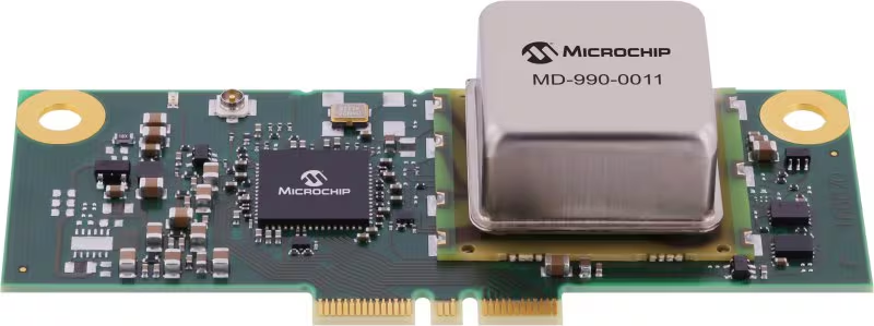
Microchip Technology has released its MD-990-0011-B family of plug-in timing modules, delivering turnkey, high-precision synchronization for data center servers and 5G virtualized radio access networks (vRAN).
Developed in collaboration with Intel, the MD-990-0011-B timing module is designed for seamless compatibility with Intel Xeon 6 SoC-powered server platforms, supporting both OEMs and ODMs in building future-ready systems. By leveraging Intel’s foundational vRAN architecture, the module enables robust, low-latency time synchronization, which is essential for distributed AI workloads and real-time applications.
Engineered for the reliability and scalability required by cloud infrastructure, virtualization and high-availability deployments, the MD-990-0011-B supports automatic source selection and locking across GNSS, synchronous Ethernet (SyncE) and precision time protocol (PTP). This flexibility supports continuous, accurate timing even as network demands evolve.
The MD-990-0011-B timing modules are available in two variants. MD-990-0011-BC01 offers eight hours of holdover performance; MD-990-0011-BA01 offers four hours of holdover performance. These timing modules consolidate several of Microchip’s advanced technologies into a single, highly integrated solution. Key components include:
Synchronous Ethernet (SyncE) synthesizer (ZL80132B). Two independent digital phase-locked loop (DPLL) channels for flexible and resilient synchronization
Oven controlled crystal oscillators (OCXOs, OX-22x). Provide up to eight hours of holdover, ensuring stable timing during GNSS outages or network disruptions
MCP9808 temperature sensor. Supports enhanced, environmental monitor 24LC024 EEPROM implementing board configuration and VC-820for low jitter performance
By unifying these critical timing components into a single plug-in module, the MD-990-0011-B streamlines server architecture, reduces design complexity and simplifies the supply chain. Its modular design enables rapid installation and simplified maintenance, minimizing downtime and facilitating effortless upgrades, key advantages for dynamic data center and 5G network environments.
The 5G PNT network in Santa Clara County will mark the first real-world demonstration of a 5G-powered backup to GPS
NextNav Inc., a leader in next-generation terrestrial positioning, navigation, and timing (PNT) and 3D geolocation solutions, will commence operations of a 5G PNT network in Santa Clara County, California, as early as Dec. 11.
Network operations of positioning, navigation and timing applications represent the next milestone toward commercial readiness and the mission to deliver a resilient complement to GPS.
The 5G PNT network will consist of multiple fixed base station locations using a standards-compliant 5G signal with a positioning reference signal (PRS) enabled, a standalone 5G core, and NextNav’s 3D PNT architecture. The network’s authorized technical parameters will align with those in NextNav’s proposal to optimize the lower 900 MHz band to enable a terrestrial, widescale backup to GPS that is broadly available to critical infrastructure, public safety and American consumers.
“We’re incredibly pleased to continue demonstrating our technology in a real-world operational environment,” said Mariam Sorond, CEO of NextNav. “Activating this network is a critical step in our commercialization process, proving that robust 5G broadband service and high-integrity PNT can be delivered together, at scale, using standard 5G equipment.”
The 5G PNT network will validate NextNav’s 5G PRS-based PNT end-to-end architecture under real-world conditions.
“This is the first public demonstration of a full-scale and operational 5G-based PNT in live deployment, delivering both resilient PNT and broadband service simultaneously,” said Arun Raghupathy, NextNav Co-Founder and CTO. “Through this commercialization deployment, we’re validating our 5G-based network can deliver accurate 3D location, improved timing synchronization, and enhanced resilience. This real-world deployment is critical to establishing U.S. leadership in next-generation PNT technologies.”
The 5G PNT network will support the broader adoption of 5G-based terrestrial PNT with 5G broadband capabilities for operators, enterprises and ecosystem partners. This deployment will also prove that NextNav’s software solution is ready to scale and deliver commercial PNT while serving the critical national security and public safety needs of the United States.
Iridium Communications is working with T-Mobile to on a broad network deployment of positioning, navigation and timing (PNT) services, starting with live-site activations across the United States. The deployments will deliver 5G network complementary timing synchronization to strengthen the cellular network’s resilience and help ensure reliability for customers.
The U.S. Department of Transportation CPNT Action Plan is designed to evaluate mature and commercially available CPNT technologies to strengthen PNT resilience and enhance the safety of critical infrastructure, like 5G networks. DOT is the U.S. government’s civil lead for PNT.
Under the contract, T-Mobile will expand its installation of Iridium PNT receivers to 90 additional live 5G network sites in geographically diverse locations. Iridium PNT will help protect against GPS disruptions that cause downtime and compromise the data integrity and performance of 5G networks, which rely on coordinated, precise timing to deliver the necessary speed, capacity and reliability of service to end-users.
T-Mobile will also perform nominal and adverse user equipment exercises at its indoor testing range. It has the necessary wireless infrastructure for DOT, Iridium, and T-Mobile to observe and record results.
Capable of sub-100-nanosecond accuracy — better than a millionth of a second — and secured using cryptographic techniques, Iridium PNT signals are 1,000 times stronger than GNSS systems like GPS and work inside buildings with no need for an outdoor antenna. The service is delivered by Iridium’s low-Earth orbit (LEO) satellite constellation, which provides global weather-resilient L-band connectivity.
NextNav Inc. has successfully advanced its NextGen PNT solution commercialization path operating on standard 5G network equipment. The development represents a major milestone toward a widescale commercial 5G-powered 3D PNT solution. The company is showcasing its solution this week at Mobile World Congress in Las Vegas, booth #96.
“This latest achievement highlights the seamless integration of NextNav’s technology and 5G, reinforcing the scalability and practicality of a resilient terrestrial complement to GPS,” said Sidd Chenumolu, chief business development officer. “We have proven the technology with standard 5G equipment and look forward to the opportunity to completing the final steps to commercialization.”
NextNav completed demonstrations using Lekha Wireless Solutions 5G base stations with positioning reference signals (PRS) enabled. The partnership with Lekha Wireless Solutions, a commercial 5G infrastructure equipment supplier, brings PNT capabilities in the NextNav spectrum band.
The demonstration delivered accurate timing and positioning information via PRS transmissions while simultaneously delivering both downlink and uplink data transmissions. These capabilities align tightly with NextNav’s broader solution of utilizing standards-based 5G PRS in lower 900 MHz band spectrum for terrestrial PNT and combining it with barometric pressure sensors for vertical accuracy.
“Demonstrating these capabilities on commercial 5G equipment is a critical step towards integrating this solution into networks, a hallmark of NextNav’s 3D PNT architecture,” said NextNav Co-Founder and CTO Arun Raghupathy. “It shows that our PNT solution can be deployed efficiently using existing 5G equipment, delivering accurate timing and positioning information along with simultaneous 5G data.”
At MWC Las Vegas, NextNav will showcase these developments as well as an interactive demonstration of the company’s Pinnacle technology, highlighting how vertical location transforms government, public safety, and commercial applications.
Innovative chip offers multiple ultra-low power connectivity options and low-power processing for internet of things (IoT) market
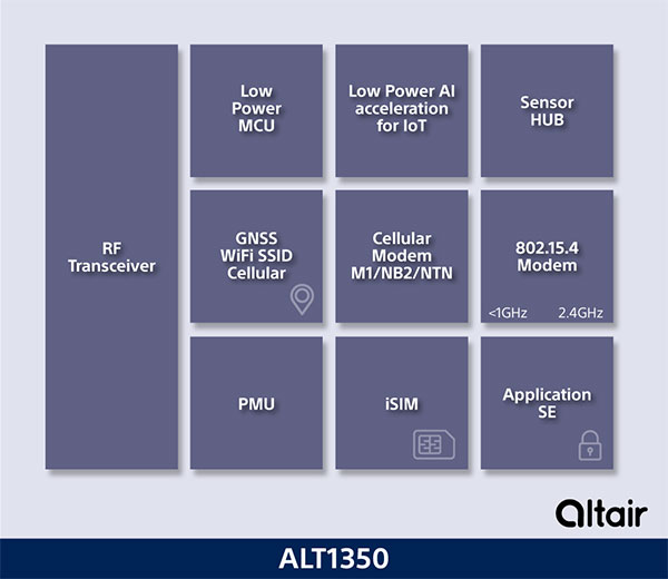
Sony Semiconductor Israel has launched the ALT1350 for the global market. The ALT1350 is a cellular LTE-M/NB-IoT chipset designed to enable additional low-power wide-area (LPWA) communication protocols, as well as GNSS, in a single chipset.
The ALT1350 incorporates a sensor hub to collect data from the sensors while maintaining ultra-low power consumption. It also provides cellular and Wi-Fi-based positioning and is tightly integrated to provide power-optimized concurrent LTE and GNSS to accommodate various tracking applications, which can be demanding with a single chip.
“The market demand for this multiprotocol, ultra-low power IoT chipset is intensifying, and Sony’s ALT1350 chipset meets that demand,” said Nohik Semel, CEO at Sony Semiconductor Israel. “This is the game changer we’ve been waiting for, which will enable IoT deployments, utilizing universal connectivity on edge processing and multiple location technologies.”
Diagram: Sony
The ALT1350 is an advanced cellular IoT solution, with architecture that resolves IoT service provider’s power-consumption concerns. Its optimized standby mode (eDRX) reduces power consumption by 80% when compared to the current generation and by 85% when using it to send short messages.
Overall improvements in the system’s power consumption will enable four times longer battery life for a typical device, enabling additional functionalities and use cases with smaller batteries.
The ALT1350’s sub-GHz and 2.4 GHz integrated transceiver enables hybrid connectivity for smart meters, smart cities, trackers and other devices. This enhances coverage, reduces costs and further decreases power consumption using IEEE 802.15.4-based protocols such as Wi-Sun, U-Bus Air and wM-Bus, in additional point-to-point and mesh technologies.
The chipset is designed to support the wide-ranging market needs of utilities, vehicle, tracking devices, smart cities, connected health and other verticals. Device manufacturers across all verticals can take advantage of its low power consumption, long-lasting battery life, mature Release 15 LTE-M/NB-IoT software stack, and future compatibility with 3GPP release 17.
All these guarantee longevity and ensure the ALT1350 will operate with 5G networks. It contains an additional LPWA radio transceiver with targeting operation in <1 GHz and 2.4 ISM bands for universal connectivity options.
The chipset provides advanced on-the-edge low power processing capabilities, ranging from data collection, low power AI/ML processing of the data, and MCU to enable IOT applications on the chip.
The device is now sampling to lead customers and will become commercially available in 2023. The ALT1350 also includes a secure element for application usage and integrated SIM designed for PP-0117 to meet GSMA requirements.
Celestia UK has won a €800,000 European Space Agency (ESA) contract to develop an innovative positioning, navigation and timing(PNT) solution based on LEO satellite constellations for 5G networks and applications.
The contract was granted under ESA’s Navigation, Innovation and Support Programme (NAVISP).
Malachy Devlin, CEO, Celestia UK
Celestia’s LEO-SYN+ project is intended to boost the reliability and performance of GNSS. It will use low-Earth-orbit (LEO) satellite signals of opportunity to provide a resilient position and time reference for 5G networks and improve the robustness of GNSS signals.
It includes development of a PNT receiver compatible with multi-GNSS constellations and LEO signals of opportunity, as well as testing of the solution in 5G networks. A prototype receiver will validate the product design and the technology development, paving the way for additional applications of the technology to other critical infrastructures after the initial ESA NAVSIP roll-out.
To deliver the ambitious project, Celestia UK is partnering with Heriot-Watt University, which brings extensive knowledge in satellite communications and digital signal processing, and The Scotland 5G Centre, the national center for accelerating deployment and adoption of 5G and realizing its economic and societal potential for Scotland.
“It is a great benefit for the business to have won an ESA NAVSIP contract,” said Malachy Devlin, CEO of Celestia UK. “We are looking forward to collaborating with ESA and our partners to unlock the potential to improve the resilience of 5G networks with our PNT solution.”
Ian Sharp, head of Business Development, The Scotland 5G Centre, added,“The Scotland 5G Centre is providing businesses access to 5G services through a national network of innovation hubs, under its 5GConnect Programme. It is well known that 5G will support higher data throughput and interactive services through reduced latency. However, 5G will also provide new possibilities for positioning, navigation and timing (PNT). Use of advanced antennas and positioning over satellite will be critical for outdoor applications where precise navigation is essential to meet safety requirements for the likes of drone navigation and autonomous vehicles. We are delighted to be working alongside Celestia UK, supporting the innovative LEO-SYN+ project, which will utilise our cutting edge 5G network.”
Net Insight’s sync solution becomes fully PTP-standard compliant with synchronization module for 5G and other mission-critical networks
Net Insight has selected Meinberg’s precision time protocol (PTP) software stack — Precision TimeNet — to implement full PTP functionality in all of its platforms.
The Precision TimeNet solution offers a GNSS-independent delivery of high-accuracy timing across any IP vendor network, which can significantly reduce the cost and rollout times of 5G and other mission-critical networks.
In 2021, Meinberg also delivered a synchronization module to Net Insight’s Nimbra MSR 300 series, providing full PTP IEEE 1588v2 interoperability and GNSS integration for 5G networks. The new module is part of the Nimbra Time Node, an important component of the Precision TimeNet solution.
Net Insight licensed the PTP stack from Oregano Systems, owned by Meinberg, to deliver network synchronization for both media and 5G networks. Meinberg leverages Net Insight’s network synchronization capabilities to serve customers across the telecom, fintech, government, and power telecom industries. The expansion into a strategic technology partnership means that both companies will utilize their expertise in time synchronization to deploy solutions that remove the challenges of reliable precision timing over any IP network.
“The shift to IP is accelerating, making precision timing key to the successful deployment of new applications,” said Heiko Gerstung, managing director of Meinberg. “Net Insight’s Precision TimeNet offers a unique solution on the market that we see a strong and growing need for, across multiple industries. We’re excited to be working with Net Insight, a leader in mission-critical IP transport, to drive innovation and enable our customers to benefit from GNSS-independent time synchronization.”
“Net Insight has been developing time transfer for nearly two decades, delivering industry-leading time accuracy and resilience over IP networks,” said Per Lindgren, CTO and co-founder at Net Insight. “When expanding our synchronization business into new markets, integrating with the IEEE 1588 PTP standard was key to enhancing our interoperability. Teaming up with Meinberg, a leader in time and frequency synchronization, was the obvious choice.. We’re excited that our joint expertise in IP networking and time synchronization will enable us to reinvent precision timing for our customers.”
Managing live sky and terrestrial time sources to protect critical infrastructure against cybersecurity threats
By Greg Wolff, Microchip Technology
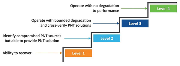
Critical public infrastructure systems that rely on GNSS for reception of positioning, navigation and timing (PNT) data have been identified by national security agencies across the globe as potential cybersecurity attack vectors. Late in 2020, the U.S. Department of Homeland Security (DHS) published the “Resilient PNT Conformance Framework” guidelines, providing a common reference point to help critical infrastructures become more resilient to PNT attack threats. Within the framework, a cybersecurity approach has been proposed.
Prevent. In this first layer of defense, threats are prevented from entering a system. However, it must be assumed that it is not possible to stop all threats.
Respond. Atypical errors or anomalies are detected and action taken, such as mitigation, containment and reporting. The system should ensure an adequate response to externally induced, atypical errors before recovery is needed.
Recover. The last line of defense is returning to a proper working state and defined performance.
Figure 1. The four levels of resilience defined in the DHS “Resilient PNT Conformance Framework” guidelines. (Image: Microchip)
Four Levels of Resilience
Based on the Prevent-Respond-Recover cybersecurity model, the PNT Conformance Framework document describes four levels of resilience. Note that the resilience levels build upon each other — Level 2 includes all enumerated behaviors in Level 1, and so forth.
The framework provides a clear set of PNT resilience guidelines for equipment, whether at the silicon, module or system level. Although the framework is not specific to the use of GNSS, much of the focus has centered on GNSS vulnerabilities and the ability to be resilient to GNSS outages, whether caused by unintentional disruptions or intentional threats. However, the GNSS resiliency of specific equipment or technology does not fully address the needs of critical infrastructure operators who are managing the use of PNT services over large geographical areas.
Critical Infrastructure Expansion
Critical infrastructure is typically constructed in a tiered manner, beginning with a set of core sites connected to secondary sites that are ultimately connected to remote sites. With the rollout of 5G networks, densification and massive deployment of wireless access points will improve coverage and enable higher bandwidths to support the internet of things (IoT) and related services. However, this massive scale of access points will also require accurate timing at a much larger number of endpoints.
Within the power utility infrastructure, the power grid is being augmented and expanded with alternative energy sources, such as solar and wind. The modernized smart grid is a highly distributed architecture that is dependent on accurate timing for coordination, monitoring and logging of data for operation and identification of power-outage fault detection. Additionally, power utilities rely on timing services for communications and transport of telemetry data throughout their entire operations.
To date, GNSS has been the go-to source for timing, creating an exponential increase in the dependency on GNSS. Because of this massive dependency, the impact of errors or interruptions today is more significant than ever before.
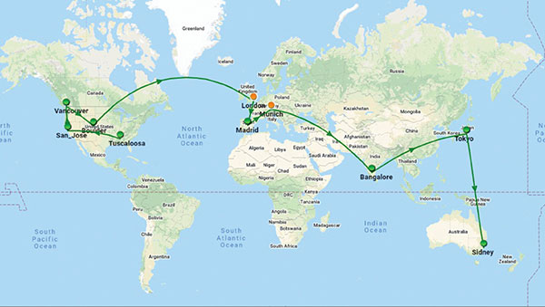
Figure 2. Example view of timing network at data centers across the globe. (Image: Microchip)
Terrestrial Time Distribution
As an alternative for delivering accurate time to large numbers of locations and reducing dependency on GNSS, critical infrastructure operators are turning to the use of terrestrial distribution using packet protocols so that high accuracy distribution can be achieved using Precision Time Protocol (PTP).
The virtual Primary Reference Time Clock (vPRTC) is a highly secure and resilient network-based timing architecture developed to meet the expanding needs of modern critical infrastructures. The vPRTC is simple in concept. It blends proven timing technologies into a centralized and protected source location, and then uses commercial fiber-optic network links and advanced IEEE 1588 PTP boundary clocks to distribute 100-ns PRTC timing where it is needed in end points that might be hundreds of kilometers away.
Just as a GNSS-satellite-based timing system distributes timing to end points using open-air transmission, the vPRTC distributes timing using a terrestrial (typically fiber) network. The difference is that the operator remains 100% in control of the network and can secure it as necessary. This network-based timing is referred to as trusted time. It can be distributed as the primary source of timing or it can be deployed as a backup to GNSS timing solutions.
Even with the many reliability and security benefits of the vPRTC approach, however, sole dependency on terrestrial time can become a single point of failure, just like a strategy dependent solely on GNSS. Because of this, critical infrastructure operators are deploying architectures that use both GNSS and terrestrial time. To do this effectively, operators find themselves with the need to have centralized management and visibility of both key sources of time. Further, to deliver on the promise of timing resiliency, a unified management system needs to include capabilities that can deliver a cybersecurity solution encompassing the Prevent-Respond-Recover DHS security guidelines across all nodes of the timing network.
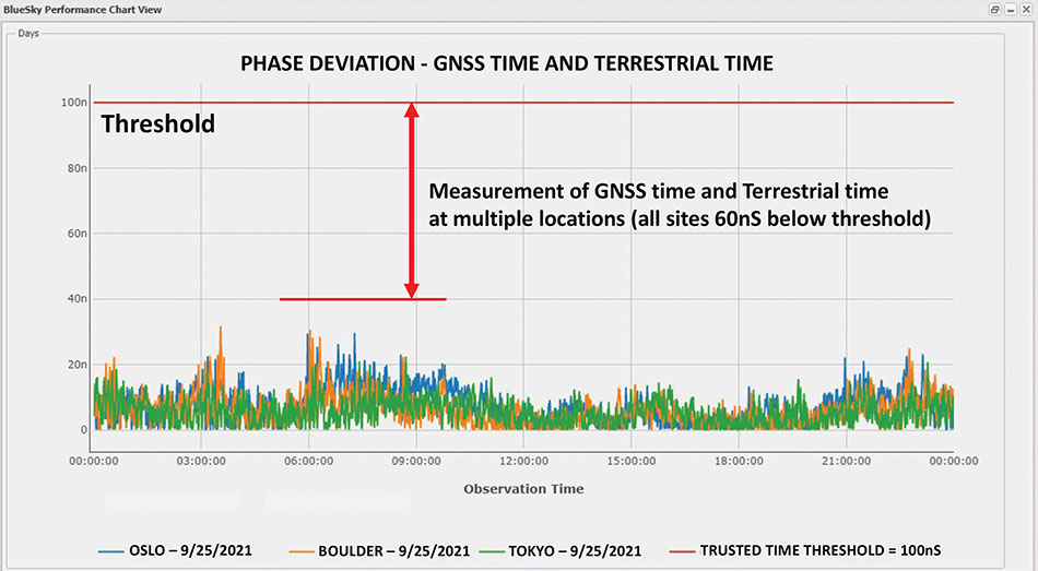
Figure 3. A measurement of phase difference between GNSS time and terrestrial time. (Image: Microchip)
Unified Time Management
Having a bird’s eye view of all nodes of a timing network is essential for providing timing security and resiliency. In the case of a GNSS anomaly or terrestrial time instability, when a problem occurs the most immediate need is to quickly identify whether the event is isolated to a specific location, affects a region, or in some cases is caused by a global situation. A centralized management and monitoring system provides a green, yellow and red threat-status indication representing different locations of interest. It is a simple way for operators to know the overall health of their timing infrastructure.
When problems surface, critical infrastructure operators next need visibility of “observables” that can quickly isolate the root cause. With today’s timing networks relying on both GNSS time and terrestrial time, the ability to see observables that represent both timing sources in a unified manner is critical.
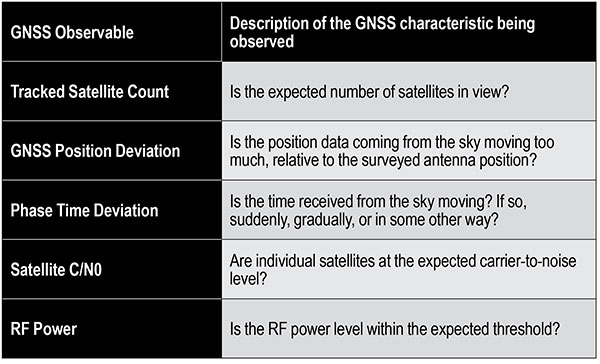
GNSS Observables
Multipath interference, weather anomalies, jamming and spoofing are terms commonly used when referring to GNSS vulnerabilities. Gaining insights (visibility) into the details to identify the root cause, however, requires more specific characterization of the signal.
Visibility into the quality of GNSS reception is accomplished by monitoring GNSS observables. Table 1 provides a sample of key GNSS observables that can be tracked and monitored.
Table 1. Sample of key terrestrial time GNSS observables.
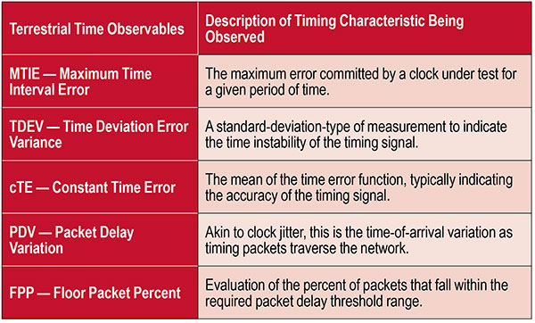
Terrestrial Time Observables
Characterizing the quality of terrestrial time requires time measurements between equipment interconnections within a single location (intra-office) or across nodes of a network (inter-office) — for example, comparison of equipment inputs and outputs or comparison of signals at different sites.
Additionally, with the standardized use of PTP, the ability to evaluate network timing packet metrics is needed to verify time transfer from location to location. Terrestrial time performance calls for a different set of observables to be made visible and monitored. Table 2 provides a sample of key terrestrial time observables.
When managing a large geographical area, being able to measure the phase difference between GNSS time and terrestrial time at multiple locations simultaneously enables an operator to determine how well these two sources of time compare. As described previously, critical infrastructure operators are ultimately in need of resiliency, which can best be achieved using both time sources.
Measuring the two sources against each other at multiple locations creates the highest level of trust knowing that these independent time sources are well aligned.
Table 2. Key terrestrial time observables that must be made visible and monitored.
Conclusion
With cooperation from industry, standards organizations and government organizations such as DHS, the use of timing services has become recognized as a foundational technology for critical infrastructure operations. Leveraging industry-standard cybersecurity models will help strengthen and harden timing equipment.
Although equipment resiliency is vital, having a bird’s eye view of timing performance across the entire network is the starting point for providing complete network visibility that is critical to providing timing security and resiliency. To deliver on the promise of timing resiliency across critical infrastructure, operators need a unified management system that enables simple and complete visibility of both GNSS and terrestrial time observables.
With a unified management of these two timing sources, operators have a platform to apply Prevent-Respond-Recover to timing threats and achieve the highest levels of resiliency and cybersecurity protection.
Greg Wolff is senior product line manager of Frequency & Time Systems at Microchip Technology. He has worked in the time and frequency industry since 1988 and was an early pioneer in the marketing of network synchronization solutions to major critical infrastructure operators across the globe. He is an active contributor to emerging standards supporting PNT resiliency and most recently, as part of Microchip Technology’s Frequency and Time Systems group, launched the BlueSky GNSS Firewall. He holds a degree in engineering science from California Polytechnic State University – San Luis Obispo.
CGI has been awarded a contract by the European Space Agency (ESA) to develop a proof of concept to enhance the navigational capabilities of airspace users in areas where traditional navigation systems alone cannot provide sufficient performance.
Future aircraft, such as UAVs and innovative air mobility solutions, will need to safely operate beyond visual line of sight (BVLOS) within cities and other built-up areas, where GNSS signals are often disrupted.
The concept being developed by CGI and its partners leverages 5G networks, alongside traditional navigation systems, to provide hybrid-positioning solutions. In addition to secure communications for command and control of vehicles, and delivery of high-quality streaming video for BVLOS operations, 5G networks can also be used as a source for navigational data that will improve the accuracy, integrity and availability beyond that which satellite navigation systems alone can provide. The service will also offer greater resilience against natural or intentional disruption of positioning, navigation and timing (PNT) services.
“The UK is a leading innovator in aerospace and GNSS technology. It’s great to see the team developing resilient PNT solutions for aerospace leveraging existing communication infrastructure,” said Andy Proctor, UK Lead Delegate to the ESA Programme Board for Navigation & PNT Innovation lead at UK Research and Innovation (UKRI). “The 5G-PNT project will enable and promote future aviation applications in the UK and globally, especially in the fast-growing future air mobility sector that will enable wider economic growth in many key sectors.”
“This exciting project brings together PNT and mission-critical systems integration expertise to advance the enabling technologies for future navigation applications,” John Hanley, Senior Vice President for UK & Australia Secure and Assured Space Solutions at CGI said. “The challenges posed by PNT service disruption have become a significant concern for operators and regulators and this project will help improve navigation capabilities to support both this challenge and further development of the aerospace sector.”
CGI will work with ESA, u-blox, the Advanced Communication, Mobile Technology and IoT (ACMI) Research Centre at the University of Sussex and air navigation service provider NATS, to define use cases and system requirements for a 5G-based complement to existing GNSS receivers. This hybrid navigation solution will be targeted at installation on any air vehicles intended to operate within the coverage of commercial 5G networks.
The project will culminate in a real-world demonstration of the technology, comparing its performance to that offered by GNSS alone.
Facebook has open-sourced the design of its time card, which features the ultra-precise u‑blox ZED-F9T timing module, providing easy access to nanosecond-level timing
Photo: u-blox
Facebook has chosen the u‑bloxZED-F9T GNSS receiver module for timekeeping, according to u-blox. By improving the synchronization of networked computers, Facebook’s time card can significantly speed up the performance of its data centers and distributed databases.
By open-sourcing their designs, Facebook has bolstered the adoption of highly accurate timing solutions based on u‑blox technology. These solutions can be adopted by other industries requiring nanosecond-level timing, such as 5G cellular networks or smart power grids.
Facebook set out to create a precise timing solution that reduces the computational overhead required when synchronizing the timing between different computers in a network, u-blox said. The social media company used a u‑blox ZED-F9T multi-band GNSS receiver to sync up its solution with the highly accurate GNSS atomic clocks. To bridge possible gaps in GNSS coverage and keep clock drift to a minimum, the time card contains a backup timing source: a miniaturized atomic clock continuously synchronized with GNSS time.
To maximize the impact of the solution, Facebook decided to open-source the design of its time card, which fits onto a PCIe form factor. Anyone with experience working with microelectronics can turn any PC built on an x86 architecture and featuring a network interface controller into a nanosecond-level-accurate timing and synchronization solution, u-blox said.
Easy access to nanosecond-level timing accuracy — based on the u‑blox RCB-F9T timing board, which hosts the u‑blox ZED-F9T GNSS receiver — opens new avenues in industry segments that rely on highly synchronized signals, such as 5G network base stations that require tighter synchronization than those of previous generations, u-blox said.
As power-distribution networks become more complex to accommodate a growing share of decentralized renewable energy, they are becoming more reliant on reliable and accurate timing solutions. Data centers and computer networks will be able to modernize infrastructure management to speed up performance and reduce latencies.
Facebook has shared the GitHub repository including the specs, the schematics, the mechanics, the bill of material, and the source code in partnership with the Open Compute Project (OCP) under the Time Appliance Project (TAP).
The company’s TimePictra 11 timing infrastructure management system works with its BlueSky GNSS Firewall to create a unified view for a more secure network timing architecture
Image: Microchip Technology
Microchip Technology Inc. has integrated its BlueSky GNSS Firewall with its TimePictra 11 synchronization monitoring and management platform to protect 5G networks and other critical timing infrastructure from GPS signal jamming and spoofing while providing single-console visibility across the entire timing architecture.
The move was made to meet the needs of 5G wireless infrastructure, which has more complex and higher density synchronization needs than previous generation networks. 5G is highly dependent on the integrity of live-sky GNSS timing signals.
“Microchip’s TimePictra system improves overall situational awareness by managing network timing synchronization as well as our GNSS firewall that improves a network’s resilience through real-time GPS threat detection and mitigation,” said Randy Brudzinski, vice president, Frequency and Time Systems business unit. “Our solution’s scalability is particularly valuable for mobile operators who can use TimePictra to monitor GNSS-based source clocks along with our secure network-based timing distribution solutions to deploy a highly resilient timing architecture for their transition to 5G.”
In addition to requiring precise timing from GNSS sources, critical infrastructure operators need accurate timing to be distributed across their networks so they can ensure reliable performance and service delivery. TimePictra provides full control and monitoring for resilient timing architectures created with Microchip’s broad product portfolio, including its TimeProvider 4100 grandmasters for 5G network synchronization.
TimePictra also monitors the health and performance of these networks’ distributed Precision Time Protocol (PTP) client clocks. Integrating BlueSky GNSS Firewall management into the TimePictra console view gives operators a unified picture of the entire timing architecture and all timing sources.
Beyond supporting 5G deployments, TimePictra provides aviation, railway and maritime ports with a regional, national or global view of GNSS reception. TimePictra with BlueSky GNSS Firewall monitors key GNSS observables to detect live-sky signal anomalies and deliver early alerting so that operators can engage alternate procedures that do not rely on GNSS. These capabilities are increasingly important when public safety depends on position and navigation for daily operations.
Microchip’s TimePictra timing infrastructure management system with its Blue Sky GNSS Firewall is available today.
Anritsu Corporation and Orolia announce immediate support of assisted GPS (A-GPS) test functionality to meet 5G New Radio (NR) Carrier Acceptance Testing (CAT) requirements for multiple North American operators on the Anritsu ME7834NR 5G mobile device test platform.
As part of the strategic partnership between the two companies, Anritsu leverages Orolia’s GNSS simulation capabilities to deliver A-GPS CAT testing platforms featuring the new Orolia GSG-SKY-ANR solution. The Anritsu MR7834NR supports A-GPS, FR1, FR2, FR1+FR2 NSA and SA US operator signaling requirements on the same platform.
The ME7834NR 5G NR mobile device test platform. (Photo: Anritsu)
The A-GPS simulation component of Anritsu’s ME7834NR-based test solution leverages Orolia’s GSG-SKY-ANR simulation platform. The GSG-SKY-ANR is powered by Orolia’s award-winning SKYDEL simulation engine, which delivers flexible, scalable, and efficient GNSS/GPS simulation solutions. The GSG-SKY-ANR GNSS simulator is exclusively available to Anritsu ME7834NR customers.
Anritsu ME7834NR A-GPS-enabled solutions for 5G NR CAT requirements are available immediately. The test solutions support the rollout of nationwide 5G networks by helping to ensure device compliance and optimum operability.
“Anritsu continues to address the needs of our customers globally,” said Shinya Ajiro, general manager of Anritsu Corporation. “By partnering with Orolia, a worldwide leader in GPS simulation technology, we are introducing a reliable, accurate, and cost-effective A-GPS CAT solution that conforms to operator requirements and delivers repeatable results. We remain committed to provide the validation tools necessary for mobile operators, device makers, chipset manufacturers, and test houses to verify designs and ensure product performance. This benefits everyone in the mobile ecosystem.”
“Orolia is proud to support North American operators through our partnership with Anritsu,” said Lisa Perdue, simulation director at Orolia. “Our resilient GPS simulation solutions deliver proven high-end capabilities for critical technology challenges such as the implementation of 5G.”