S.E.A. Datentechnik GmbH is partnering with M3 Systems on advanced GNSS emulation technology. The new partnership aims to provide high-quality GNSS tools for current and future automotive vehicle-to-everything (V2X) communication and advanced driver-assistance systems (ADAS) applications.
S.E.A. Datentechnik is a developer and system integrator for advanced radio frequency and V2X test and measurement systems, serving chipset vendors, automotive suppliers and OEMs.
The StellaNGC Software Suite by M3 Systems integrates seamlessly into automotive test environments to meet customer needs.
The two companies are leading, well established partners for the National Instruments (NI) platform. The signed partnership ensures the availability of advanced and competitive technology for global test solutions.
“We are sure that the cooperation of our companies provides a high value for customers for the development, validation and production test of actual and future V2X and Connected Car technologies,” said Gerd Schmitz, co-founder, and CEO of S.E.A. “The combination of the deep experience GNSS technology of M3 Systems with S.E.A. V2X products and competence provides tailored test solutions for reasonable cost.”
“M3 Systems is pleased to be working with S.E.A. on V2X and ADAS using the NI platform,” said Marc Pollina, CEO of M3 Systems. “V2X expands the capability of M3 Systems to serve automotive suppliers, chipset vendors and other V2X/ADAS users. V2X is synergistic with M3 Systems’ expertise in GNSS technology and simulation.”
V2X from S.E.A.
Compact, automated turnkey S.E.A. test systems enable the efficient and reliable test of V2X technologies using scalable software and hardware components.
The modular V2X test platform from S.E.A. is based on software-defined radio (SDR) technology and includes all aspects of automated V2X test, including measurements on the physical layer for RF-compliance, protocol or production testing, and integrated V2X traffic scenario simulation for the test of V2X applications.
International V2X standards for North America, Europe and China are supported for scenario-based testing by open-loop or closed-loop hardware-in-the-loop (HIL) systems. Test catalogs for specific test applications such as RF-conformance measurements and V2X Day 1 Use Case testing are available for efficient use of the flexible test systems.
GNSS from M3 Systems
High-quality simulation of GNSS signals for the different constellations — GPS, Galileo, Glonass and Beidou — are required for V2X and ADAS test system applications.
The M3 Systems StellaNGC Software Suite integrates seamlessly into the test environment and fulfills the high demands of customers. The application of the NI PXI platform for GNSS and communication emulation enables the powerful and seamless integration of GNSS as well as other sensor and communication technologies: radar, lidar and cameras for HIL ADAS/autonomous technology test systems.
A roundup of recent products in the GNSS and inertial positioning industry from the March 2022 issue of GPS World magazine.
OEM
Correction Service
Achieves RTK-level accuracy
Photo: Hexagon
“RTK From the Sky” technology has been integrated into the core of the TerraStar-C PRO corrections service. As a result, TerraStar-C PRO provides centimeter-level accuracy, not just in open-sky environments but also across challenging conditions created by buildings and foliage. TerraStar-C PRO now converges in less than three minutes by utilizing quad-band receiver and antenna technology to leverage modernized BeiDou 3, GPS III and Galileo E6 signals. The resulting process generates state-of-the-art corrections for all GNSS frequencies. The service improvements are accessible through the 7.08.10 firmware release for users of OEM7700, OEM719 and OEM729 cards and their associated enclosures for land and air applications.
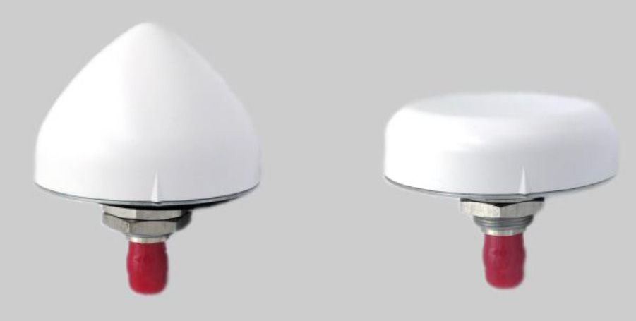
A north orientation mark is being added to the TW3000 family of Accutenna precision antennas and the TW5000 family of smart antennas. The new feature allows customers to align their antennas, standardize radiation patterns, and increase the synchronicity of their azimuth gain readings across multiple devices. The new north mark design has been thoroughly tested to ensure it conforms to or exceeds customer expectations and maintains each antenna’s stringent IP69K rating.
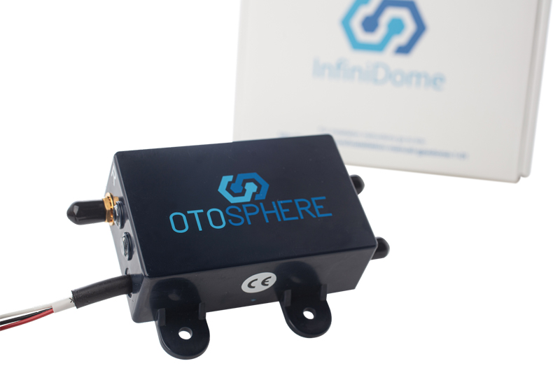
OtoSphere is a small, add-on module to the ViaLite GPS RF over fiber link and any GNSS-based system, providing GNSS protection against GPS jamming attacks, making any receiver more resilient. It ensures continuity of timing and navigation capability and enables normal operation during a jamming attack. According to ViaLite, no other solution that offers such protection is as small, light, affordable, or easy to install. The Otosphere protection module adds resilience to critical GPS timing services.Using OtoSphere, GPS receivers are up to 50 times more resilient to jamming attacks on positioning, navigation and timing (PNT) systems compared with having no protection. The GPS receiver can continue working normally throughout the attack. Timing-critical infrastructures in areas such as defense and cybersecurity can now be protected from these attacks. The Otosphere has a unique interference filtering algorithm that combines patterns from two external omnidirectional antennas that pinpoints the direction of the attack, then directs a null toward the unwanted signal to reject and reduce disruptions.
Infrastructure system for autonomous transportation
Photo: Seoul Robotics
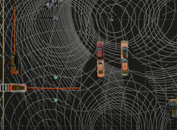
The Level 5 Control Tower (LV5 CTRL TWR)) is a mesh network of sensors and computers on infrastructure that guides vehicles autonomously without requiring that sensors be placed on individual vehicles. The technology is automating last-mile fleet logistics at BMW’s manufacturing facility in Munich. The system has the potential to transform operations for a wide range of business applications, from vehicle distribution centers to car rental companies and trucking logistics.
Savvy Navvy provides essential marine information, allowing boaters to cross-check their traditional navigation plans. It integrates plotting charts, weather and tide data, marina details and passage planning into one app. The app reduces the risk of human error as well as the stress of voyage preparation. It is used by boaters in more than 100 countries around the world, with more than 43 million miles plotted. It works on phones or tablets using Android, IOS, PC or Mac.
The Pix4D viDoc RTK handheld rover attaches to iOS devices to bring RTK accuracy to terrestrial scanning on iPhones and iPads. When paired with the PIX4Dcatch mobile app, the viDoc rover can replace survey tools such as RTK GNSS rovers and terrestrial scanners, the company said. The two products create a workflow that turns iPhones or iPads into an accurate terrestrial scanning device, with centimeter-accurate RTK positioning from an existing NTRIP network. The tools can be used to 3D model small areas or structures.
Bad Elf now provides an integrated laser-offset workflow for acquiring high-accuracy field data in GNSS-challenged environments using Esri ArcGIS Field Maps for Android, as well as iOS. The workflow integrates Bad Elf and Laser Tech (LTI) hardware in collaboration with ArcGIS technology from Esri. The Bad Elf Flex connects to any LTI TruPulse rangefinder over a wired or Bluetooth connection to deliver high-accuracy location data to Esri ArcGIS Field Maps. Mobile workers can efficiently complete position and height data collection in access-limited situations, saving time, money and effort.
A free global map created from processed satellite imagery is available. To create the world image, satellite imagery was processed to remove clouds and balance shades and tones, and then carefully stitched together to create a seamless map layer with beautiful colors. The input data is recent, from 2020 and 2021, and rendered as one tiled file with 13 zoom levels 0-13 for use in web applications. It is a viable, up-to-date alternative to Google maps for software developers, without privacy issues.
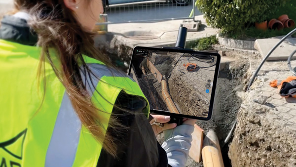
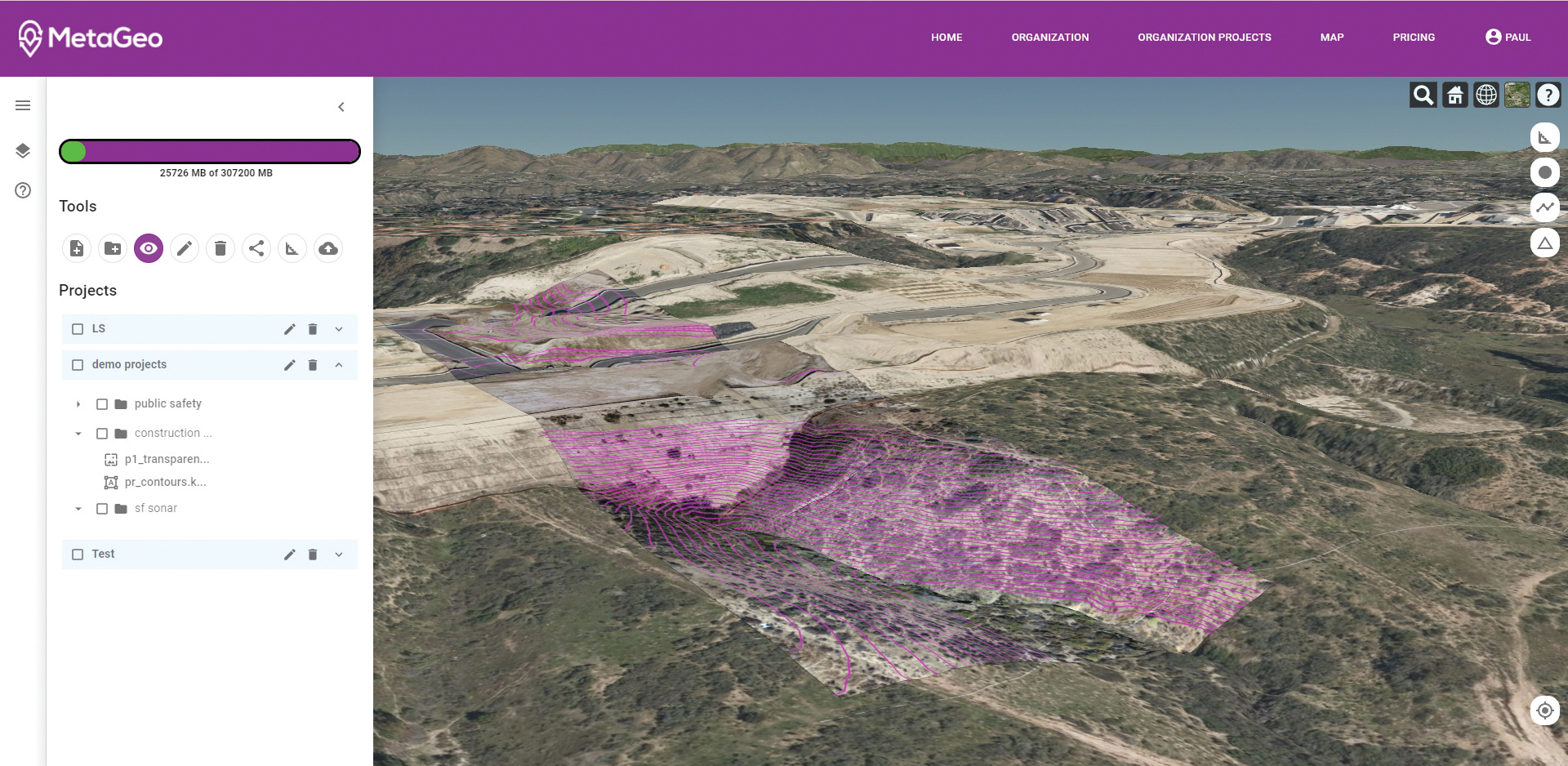
The MetaGeo geographic information system (GIS) platform enables organizations of all sizes to host, analyze, find and share 3D map datasets among any internet-capable devices. The platform processes location-based map or sensor data from the real world, combines it into a single 3D virtual environment, and streams it to any device or mapping platform. The affordable and easy-to-use platform can load data from multiple sources: satellites, drones, mobile devices, public and crowdsourced repositories, internet of things (IoT) sensor data, 3D models and topographic maps. The data is then processed by the MetaGeo platform into a 3D world and streamed to any internet-connected device, enabling live collaboration between the office and field via mobile or augmented reality device. A plug-in software development kit (SDK) allows for third-party tools to scale and fit user needs.
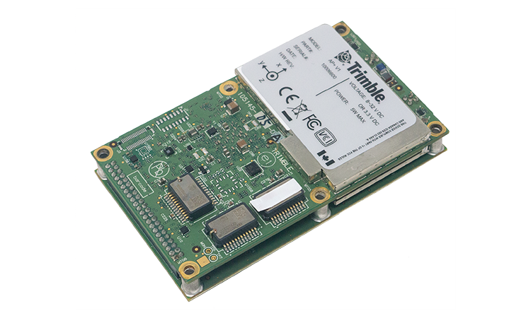
Trimble has launched the Trimble AP+ Land GNSS-inertial OEM platform for accurate and robust position and orientation for georeferencing sensors and positioning vehicles in land mobile-mapping applications. The platform enables users to accurately and efficiently track and monitor fleets and produce high-definition (HD) maps and 3D models. It can also serve as a reference solution for advanced driver-assistance systems (ADAS) testing, even in challenging GNSS environments. The comprehensive Trimble AP+ Land is small enough to integrate into compact mobile-mapping systems. It is compatible with virtually any type of mapping sensor, including single- or multi-lidar systems, video cameras, photogrammetric and panoramic cameras, and similar sensors.
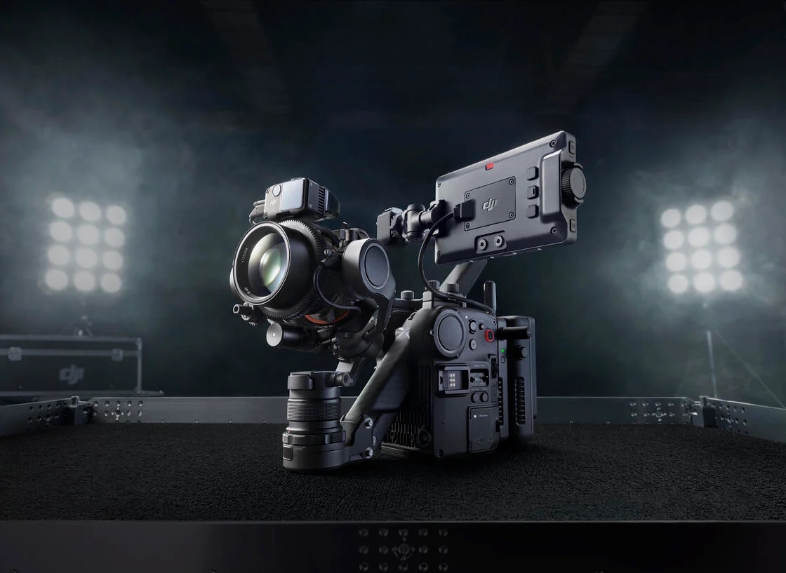
Ronin 4D, a professional cinema camera from DJI, incorporates the full-frame Zenmuse X9 gimbal camera, active four-axis stabilization, lidar focusing, and wireless transmission. Firmware available at launch will allow the remote monitor to view and control the main monitor, interface with mirror control mode, and allow a clean video stream over HDMI and SDI ports on the Remote Monitor Expansion Plate with no overlaid information. It will also support automatic calibration for some third-party auto lenses to realize Lidar Focusing System functions.
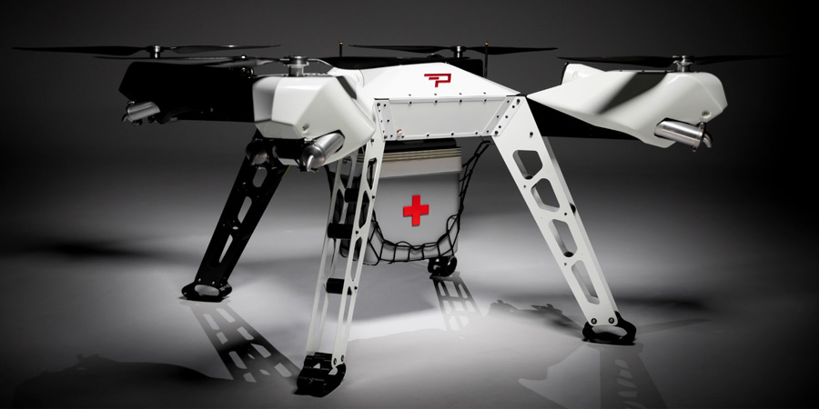
Parallel Hybrid Electric Multirotor (PHEM) drone technology improves flight time with a heavy payload, yielding increased efficiency and eliminating the large battery used in other hybrids. It has the potential to extend a UAV’s flight time from 15 minutes to well over an hour and drastically increase range. In the search-and-rescue field, a heavy-lift drone can enhance first responder capabilities by allowing for substantially quicker response times to remote locations. Other applications include military platforms, fighting wildfires, and medical and logistics missions.
Expected to be available in the second quarter of this year, Trimble’s RTX service will enable superior location capabilities in premium Android smartphones worldwide.
The integration of Trimble RTX GNSS technology, a correction services platform, with Snapdragon contributes to a higher quality, more accurate location-based user experiences such as car navigation with lane-level guidance.
Coupling the Trimble RTX technology with premium Snapdragon Mobile Platforms will enable smartphone manufacturers, service providers and application developers using Snapdragon to provide mobile users with robust meter-level accuracy (or about 3 feet) when used with a Trimble RTX-based correction service. This represents a five times improvement in location accuracy compared to typical accuracy.
Location information accuracy can significantly improve the smartphone’s user experience when using mapping, driving or other mobile applications. For example, with more accurate positioning for a ridesharing app, both driver and rider can have a better experience when the pick-up destination is more precisely displayed. In addition, lane-level accuracy enables drivers to gain greater map detail and more accurate directions when using real-time navigation applications.
The new collaboration expands Trimble’s existing relationship with Qualcomm Technologies to provide high-accuracy positioning solutions for connected vehicles, advanced driver-assistance systems (ADAS) and autonomous driving solutions to automotive OEMs and Tier 1 suppliers.
“Trimble and Qualcomm Technologies have a history of innovation in mobile location technologies, both separately and collaboratively,” said Lisa Wetherbee, general manager of Trimble Advanced Positioning. “Together, we are boosting premium Android phone functionality, helping mobile applications provide better information about the user’s immediate surroundings.”
“Precise positioning, where accuracies are down to a meter or less, is a necessary capability in next-gen premium Android phones, providing better mapping, more accurate navigation and new exciting services to consumers,” said Francesco Grilli, vice president, product management, Qualcomm Technologies. “Snapdragon is again taking location-based experiences to a new level through this collaboration with Trimble.”
Qualcomm Technologies Inc. and Ferrari N.V. have entered a strategic technology collaboration aimed at helping accelerate the digital transformation of Ferrari.
Qualcomm Technologies will serve as Ferrari’s systems solutions provider for its upcoming Ferrari road cars, as well as a Premium Partner for the Scuderia Ferrari Formula 1 team and Ferrari eSports team.
Ferrari will work with Qualcomm Technologies to utilize the Snapdragon Digital Chassis to bring the latest automotive technology advancements to Ferrari road cars.
The Snapdragon Digital Chassis is comprised of open and scalable cloud-connected platforms needed for next-generation vehicles, which includes telematics and connectivity, the digital cockpit, and advanced driver-assistance systems (ADAS) functions. It utilizes a unified architecture to deliver enhanced safety and immersive digital experiences updateable throughout the lifetime of the vehicles.
As a part of the agreement, Qualcomm Technologies and its partners will also work with Ferrari to design, develop and integrate Ferrari’s digital cockpits.
Qualcomm Technologies will begin serving as a Premium Partner of the Scuderia Ferrari Formula 1 team at the start of the 2022 FIA Formula One World Championship race season, where Snapdragon will be featured on the new Scuderia Ferrari’s F1-75 single-seaters. The Maranello marque’s eSports activities will also be part of the official partnership.
The Snapdragon Digital Chassis connects cars to the cloud. (Image: Qualcomm)
Farmers rely on their GNSS receivers to keep their machines on track, their maps accurate, and their rows straight in demanding environments. GNSS receivers on agricultural equipment need to continue to perform at a high level when faced with extreme weather, temperature and vibration while navigating varying terrain. In addition, farmers rely on the correction services that provide them with the high accuracy needed to keep them operating. Still, they face challenges with outages and interruptions from obstacles blocking satellite signals.
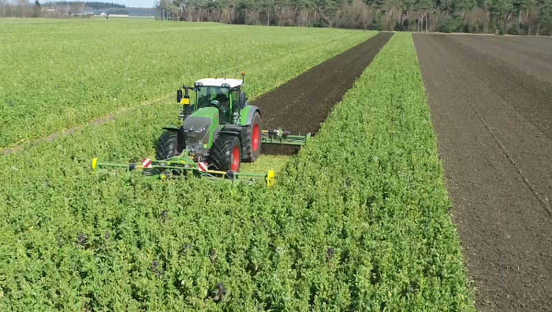
Hexagon | NovAtel’s SMART7 GNSS receiver and TerraStar Correction Services together create an accurate, robust and reliable solution for farmers. These products undergo extensive testing to ensure a high-performing and dependable solution. The SMART7 accesses all four GNSS constellations (GPS, GLONASS, BeiDou and Galileo), providing the best availability in variable terrain and environmental conditions. To compensate for the pitch and roll in the field, the receiver includes terrain compensation — keeping farmers at centimeter-level accuracy when using TerraStar-C PRO, TerraStar-X or RTK corrections.
Photo: Hexagon | Novatel
TerraStar Correction Services are based on a global network of advanced and proprietary GNSS control centers to ensure 99.999% signal availability to farmers. By delivering quality satellite corrections without the need for base stations, farmers can get the accuracy needed for their operations in a scalable format that moves with their equipment.
Jacob Van Den Borne is a potato farmer in the southern region of the Netherlands. He has been working with precision farming for more than 10 years and recently switched his Fendt tractor to NovAtel’s SMART7. Throughout his last season, Jacob noticed a substantial improvement in signal reception while passing along the edges of his heavily treed field. Previously, his GNSS equipment would lose reception, causing his rows to wander. After using a SMART7 for one season and experiencing its high precision and reliability, Van Den Borne plans to switch all receivers on his farm to the SMART7.
Evolving advanced driver-assistance systems (ADAS) and developing safe perception and positioning systems in the agriculture industry are top priorities for NovAtel. With the challenges faced by farmers, finding new ways to support a sustainable increase in their production and productivity will help ease the pressures of a growing population.
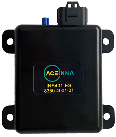
Aceinna Inc. has announced the INS401 INS and GNSS/RTK, a turnkey solution for autonomous vehicle precise positioning. Aceinna made the announcement at the Consumer Electronics Show (CES) taking place this week in Las Vegas.
The INS401 is part of Aceinna’s new product portfolio that provides high accuracy and high integrity localization for developers and manufacturers of advanced driver-assistance systems (ADAS) and autonomy solutions for vehicles of all types.
The INS401 is a high-performance inertial navigation system (INS) with a dual-frequency GNSS receiver enabled with real-time kinematic (RTK). It also features triple-redundant inertial sensors and a positioning engine. It is designed for use in Level 2 and higher ADAS and other high-volume applications requiring precise position information.
The INS401 provides centimeter-level accuracy, enhanced reliability and superior performance during GNSS outages. The dead-reckoning solution delivers strong performance in GNSS-challenged urban environments.
The INS401 is specifically developed for automotive applications using automotive-qualified components and is certified to ASIL-B level according to ISO26262.
INS401 is small, compact and turnkey with a rugged aluminum housing. It includes everything needed for design and development of a robust navigation system with a flexible platform enabling easy customization for fast time to market. The included integrity engine guarantees zero performance failure.
“Based on a decade-long history in ADAS and safety applications, Aceinna is ready for today’s and future autonomous mobility applications,” said Wade Appelman, president and COO of Aceinna. “The INS401 is our next step forward, delivering complex INS/RTK technology to mass markets with turnkey products.”
Swift Navigation designs, manufactures and integrates GNSS receivers, as well as providing the Skylark wide-area GNSS corrections service. Its markets are automotive, transportation (last mile delivery, commercial trucking, rail), robotics/machine control (construction, mining, precision agriculture, landscaping), UAVs, micromobility and mobile devices and applications.
The company’s technology is compatible and interoperable with most major GNSS receivers for multiple markets. Its Starling positioning engine and Skylark corrections “are scalable to bring precision to legacy low-cost single-frequency receivers, all the way to the most sophisticated state-of-the-art triple-frequency multi-constellation systems,” said Joel Gibson, Swift’s executive vice president of Automotive. “By working with a multitude of receiver vendors for different applications, Swift leverages all constellations and all signals and maximizes the performance required for the application.”
The most accurate and reliable navigation system for every application would take advantage of all available GNSS signals, as well as all available corrections, dead reckoning and fused data from other sensors, such as cameras, lidar and radar. However, of course, that is not possible due to cost, size, weight and power considerations. Swift’s approach to the trade-offs required depends on each use case.
Micromobility
In the area of micromobility (such as scooters), the main constraints for implementing a positioning solution are cost and power, coupled with the challenge of satellite signal outages and multipath in dense urban environments where these vehicles primarily operate, Gibson explained. “Cost-effective dual-frequency GNSS receivers are now showing up in micromobility architectures. Pairing them with our Starling positioning engine, which integrates inertial sensor data and wheel ticks, and augmenting them with Skylark corrections data, makes it possible to meet such compliance requirements as geofencing and limiting sidewalk use.”
Additionally, by achieving decimeter-level positioning, Swift’s micromobility solution makes it easier for both users and service staff to find scooters, which increases the scooter companies’ revenues.
Photo: Swift Navigation
Automotive
In the automotive industry, inertial sensors and wheel odometry are ubiquitous and pair naturally with GNSS to mitigate satellite signal outages, Gibson pointed out. Likewise, cameras and radar — cornerstones of ADAS — are very complementary to GNSS for safety applications, and lidar further complements GNSS in feature-rich environments such as dense urban areas.
Rail
Rail applications, such as Positive Train Control, have traditionally needed an accuracy of one or two meters, coupled with ruggedized hardware. “Swift’s precise positioning solution is deployed across continental rail systems today, and we are now engaging rail OEM and operator programs requiring sub-meter accuracy to ensure track-to-track accuracy and safety requirements in support of the transition to more autonomous rail operations,” said Gibson. “Leading rail companies are also looking for operational efficiencies by transitioning away from the high operational costs of maintaining reference base stations along track routes, instead moving to the more cost effective, reliable and seamless Skylark corrections coverage.”
Swiss company u-blox designs and manufactures GNSS receivers used in the automotive market, including driverless cars, and for micro-mobility devices, such as the Bird scooter.
In deep urban canyons, the biggest challenge for positioning cars is achieving sufficient accuracy despite multipath, said Aravinthan Athmanathan, product manager for the company’s Automotive GNSS line of receivers. “The challenge for autonomous driving is reliable lane-accurate positioning and integrity.”
The company develops its own dead-reckoning algorithms, which use data from an inertial measurement unit (IMU) and wheel speed sensors. “We also provide dual output, so the end customer can choose whether to use GNSS only or a sensor-fused solution,” said Athmanathan. This is especially challenging at the sub-meter accuracy level.
Different Uses, Different Sensors
Different automotive use cases require different GNSS receivers. To meet this challenge, u-blox offers the NEO-M9L for standard precision and the ZED-F9K for high precision, depending on the customer’s needs. Additionally, it is investing a lot “in functionally safe GNSS and in being the GNSS enabler for car manufacturers,” said Karin Steinhauser, the company’s senior marketing communications manager.
For navigation with meter-level accuracy, the NEO-M9L is integrated with dead-reckoning technology and sensor fusion, using algorithms that process sensor data from the IMU and from wheel-speed sensors. It can provide reliable location data in challenging environments, such as urban canyons, where multipath becomes an issue, or tunnels, where GNSS signals are partially or totally denied, Steinhauser said. Additionally, the NEO-M9L can operate in temperatures of up to 105° C, making it suitable for integration on the roof, behind the windscreen, or inside hot electronic control units. The NEO-M9L addresses the use cases in urban environments for both navigation and systems, such as Europe’s eCall, that provide an automated message to emergency services following a road crash, including the precise location of the accident.
The ZED-F9K, on the other hand, is well suited for use cases at the higher levels of advanced driver assist systems (ADAS) defined by the Society of Automotive Engineers (SAE), which require decimeter-level accuracy. “At L3 and above, you need correction services with integrity to allow for trustworthy and reliable GNSS positioning,” Steinhauser said. “We have partnerships with Bosch on projects to develop functionally safe GNSS solutions based on a ISO26262-certified version of u-blox generation 9 GNSS technology.” The ZED-F9K is a multi-band receiver that uses GPS signals on L1-L2 and Galileo signals on E5b. “We also have a special set of features adequate for the ADAS and the autonomous driving features,” Athmanathan said.
Image: 3alexd/E+/Getty Images
Bottlenecks
One of the factors limiting how quickly u-blox can roll out solutions based on the ISO 26262 standard (titled “Road vehicles – Functional safety”) is that highly autonomous systems require more integration work by the customers, said Alex Ngi, the company’s product manager for High Precision GNSS. “The first systems are now available.” Another hurdle, he pointed out, is the legal framework for deploying autonomous driving systems. “The regulations about how things need to be tested, and the liabilities for when systems fail, affect how quickly these systems can get adopted.”
GNSS can be used as a complementary technology to enable absolute positioning for systems that fuse data streams from cameras and lidars, such as those used for ADAS level 2 applications. “Fusing all this is computationally intensive and requires high processing power, such as NVIDIA GPUs, which tend to be very hot systems. We see a lot of requirements for very high-temperature GNSS receivers, because our receivers are often co-located with these hot systems.”
Of course, u-blox does not simply hand its modules to Bosch and car manufacturers and say, “You take it from here.” Design and integration is an iterative process. “We bring in the GNSS know-how and integration support and Bosch brings in the functional safe automotive development know-how,” Ngi said.
Dead Reckoning and Map Matching
For the automotive market, u-blox has more than 20 years of experience with dead reckoning. “The sensor-fusion solution receives data from both the GNSS and the IMU, and we provide the complete final solution,” Athmanathan explained.
The system also aids the receiver by providing it external map data. “If you’re driving your car northbound and the GNSS receiver tells you that it’s headed in the opposite direction, or that you’ve jumped over to the lane to the other side of the highway, clearly that cannot be right,” Ngi said. “Map matching relies on simple messages that come into our receivers to give us positive feedback on our measurements.”
For non-automotive applications, u-blox makes the ZED-F9R. It is used, for example, in robotic lawnmowers, very common in Asia and Europe, which require centimeter-level accuracies. “That’s why it focuses on delivering corrections using SPARTN, which can be a continent-wide data stream,” Ngi said. “We also make the design so that it’s very easy to integrate and enables the designers to easily pass the corrections to their receivers fully encrypted. This way, the value of the data is delivered to the lawnmower without exposing it to the system designer, so that we don’t need to go check every design to see whether somebody is leaking secured correction services.”
By the end of November, according to u-blox, updates of the ZED-F9P multi-band GNSS receiver will include decryption of the SPARTN correction data and a 95-percentile protection level. The protection level increases the trust non-safety-critical applications can place in its position output. By continuously outputting the upper bound of the maximum likely positioning error, referred to as the protection level, the receiver lets autonomous applications, such as UAVs or robotic lawnmowers, make efficient real time path planning, increasing the quality of their operations.
Guiding eScooters and EVs
In some places, Ngi pointed out, e-scooters are required to use a bike lane, which might be only two or three feet wide and may not be along the side of a building as it would be on a sidewalk. “The ZED-F9R is a much more flexible solution than camera systems that only know sidewalks or bike lanes.” Bird uses it to throttle driving speeds to match speed limits, which change from one location to another. “It is also much more scalable for them as opposed to such solutions as using UWB [ultra-wideband] beacons to fence off different areas, which are not really scalable for a company that wants to deploy solutions to hundreds of cities.”
Xpeng Motors, a manufacturer of smart electric vehicles, uses u-blox F9 GNSS receivers, which use signals from all four GNSS constellations, in its P7 super-long-range sports electric vehicle sedan. The vehicle uses ADAS for navigation-guided driving, automated parking and autonomous driving. For instance, once a navigation destination is set on a specific highway, the P7 will follow the route guidance to execute autonomous lane changing, switch to high-speed routes, and select the optimal route in real-time.
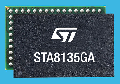
STMicroelectronics has introduced an automotive satellite-navigation chip designed to deliver high-quality position data needed by advanced driving systems.
Joining ST’s Teseo V family, the STA8135GA automotive-qualified GNSS receiver integrates a triple-band positioning measurement engine. It also provides standard multi-band position-velocity-time (PVT) and dead reckoning.
The STA8135GA’s triple-band enables the receiver to efficiently acquire and track the largest number of satellites in multiple constellations simultaneously for superior performance in difficult conditions such as in urban canyons and under tree cover.
Triple band has historically been used in professional applications such as surveying, mapping and precision agriculture that demand millimeter accuracy with minimal reliance on correction data, usually available on larger and more expensive modules than ST’s single-chip STA8135GA.
The compact STA8135GA will help driver-assistance systems make accurate decisions about the road ahead. The multi-constellation receiver delivers raw information for the host system to run any precise-positioning algorithm, such as PPP/RTK (precise point positioning/real-time kinematic). The receiver can track satellites in the GPS, GLONASS, BeiDou, Galileo, QZSS and NAVIC/IRNSS constellations.
The STA8135GA also integrates separate low-dropout voltage regulators on chip to supply the analog circuitry, digital core and input/output transceivers, simplifying selection of the external power supply.
The STA8135GA also enhances the performance of in-dash navigation systems, telematics equipment, smart antennas, V2X communication systems, marine navigation systems, drones, and other vehicles.
“The high precision and single-chip integration delivered by the STA8135GA satellite receiver enables the creation of reliable and affordable navigation systems that enable vehicles to be safer and more context aware,” said Luca Celant, general manager, ADAS, ASIC and Audio Division, Automotive and Discrete Group, STMicroelectronics. “Our unique in-house design resources and processes for high-yield manufacturing are among the critical capabilities that have made this industry-first device possible.”
The STA8135GA is housed in a 7 x 11 x 1.2 BGA package. Samples are available now and full qualification AEC-Q100 and Start Of Production are scheduled for the first quarter of 2022.
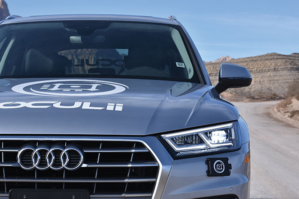
An Oculii sensor placed at the front corner of a vehicle. (Photo: Oculii)
Oculii’s patented adaptive AI software increases resolution of existing RF radar silicon up to 100X
Ambarella Inc. has entered into a definitive agreement to acquire Ohio-based Oculii Corp. Oculii’s adaptive artificial intelligence (AI) software algorithms are designed to enable radar perception using current production radar chips to achieve significantly higher (up to 100x) resolution, longer range and greater accuracy.
The fusion of Ambarella’s camera technology and Oculii’s radar software stack provides an all-weather, low-cost and scalable perception solution, enabling higher levels of autonomy for Tier 1 automakers and OEMs globally.
Oculii’s technology eliminates the need for specialized high-resolution radar chips, which have significantly higher power consumption and cost than conventional radar solutions. Oculii’s software can be deployed on Ambarella’s existing CVflow systems-on-chip (SoCs), operating in conjunction with radar RF solutions to increase safety and reliability.
The acquisition expands Ambarella’s addressable market into radar perception and fusion with its existing SoCs for automotive and other internet of things endpoint applications, including mobile robotics and security.
Oculii’s superior resolution and sensitivity can unlock the potential of everything from advanced driver-assistance systems (ADAS) and autonomous vehicles to robotics and security, by providing radar with a dynamic waveform that uses AI to learn from and adapt to the environment. The result is an extended operating range of up to 400 meters with a wide field of view.
To date, Oculii is engaged with 10 of the top 15 Tier 1s on software licensing, and has commercial development contracts with other OEM and AV companies. Oculii is generating pre-production revenue today, with production programs expected to commence in CY2023.
The boards of directors at both companies have approved the transaction, which is subject to customary closing conditions and expected to close during Ambarella’s Q4 FY2022 (ending January 31, 2022). Wilson Sonsini Goodrich & Rosati served as legal advisor to Ambarella, and Goodwin Procter served as legal advisor to Oculii. Greenhill & Co. served as financial advisor to Ambarella.
The GNSS augmentation service provides real-time, verified and scalable high-precision positioning to consumer, industrial and automotive applications.
U-blox has launched its new PointPerfect location service. PointPerfect delivers an advanced GNSS augmentation data service designed from the ground up to be ultra-accurate, ultra-reliable and immediately available.
The service enables the fast-growing demand for high-precision GNSS solutions including autonomous vehicles such as unmanned aerial vehicles (UAV), service robots, machinery automation, micro-mobility and other advanced navigation applications.
Emerging automotive applications include automated driving (AD) and advanced driver assistance systems (ADAS), lane-accurate navigation and telematics.
Delivered via mobile internet or L-band satellite signals, PointPerfect broadcasts on a continental scale with homogeneous coverage in Europe and the contiguous United States, up to 12 nautical miles off coastlines to any number of end-devices, delivering sub-10-centimeter positioning accuracy and convergence of seconds. It uses the SPARTN messaging format with the lightweight, secure MQTT internet of things (IoT) delivery protocol for a real-time, bandwidth-optimized, cost-efficient solution for mass-market applications.
PointPerfect cooperates smoothly with u-blox positioning and connectivity hardware, providing a one-stop-shop solution from silicon to cloud. Because it is based on the open SPARTN GNSS correction data format, its use is not restricted to a single hardware provider, allowing customers the flexibility to optimize solutions.
PointPerfect is delivered via the Thingstream IoT service delivery platform, an enterprise-grade cloud platform that supports billions of messages. Thingstream provides a self-serve environment where users can manage their device fleet, optimizing cost and performance through flexible and predictable pricing plans.
The service is backed by a full warranty, 99.9% uptime availability and 24/7 reliability. In-house development of all the technological building blocks ensures expert technical support while eliminating any external dependencies that could otherwise lead to delays.
“PointPerfect seamlessly integrates our advanced high accuracy GNSS augmentation service with industry-leading positioning and connectivity hardware,” said Franco de Lorenzo, principal product manager services, u-blox. “Designed for increased flexibility, PointPerfect lowers barriers to adoption and supports scaled-up high precision positioning solutions, even in segments where such solutions would previously have been considered impractical. Moreover, innovative delivery options fully integrated into our easy-to-use Thingstream IoT service delivery platform eliminate complexities and allow users to engage more efficiently, reducing time-to-market.”
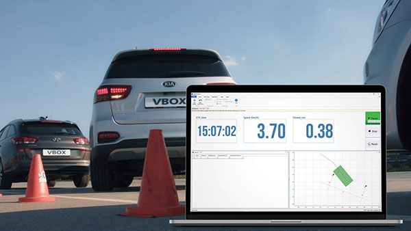
A test of Racelogic’s parking assistance system. (Photo: Racelogic)
Racelogic helps vehicle manufacturers develop autonomous vehicle technology and test them on indoor test tracks and the open road.
Racelogic helps vehicle manufacturers develop autonomous vehicle (AV) technology and testing houses test them. Over time, regulatory and consumer testing has evolved from indoor test tracks to outdoor open-road tests, and then to indoor controlled test environments.
“Due to their application, advanced driver-assistance systems (ADAS) originated and are still mainly developed and assessed on open-sky, controlled test tracks, tackling the most common killed and seriously injured (KSI) accident types,” said Wesley Hulshof, principal engineer – ADAS Testing at Racelogic. “These assessments usually make use of sophisticated driving robots for closed loop, centimeter-accurate path following and precise speed-controlled test-track assessments. The robots can only attain this accuracy by being fed the speed and positional data by GNSS sensors, such as the Racelogic VBOX.”
Accuracy is key to conducting assessments for the European New Car Assessment Programme (Euro NCAP) and the U.S. National Highway Traffic Safety Administration (NHTSA). Using GNSS in conjunction with RTK base stations provides centimeter-level accuracy in position, said Hulshof, as well as accurate speed and heading information to measure ADAS data to both static and moving targets. Additionally, combining a GNSS receiver with an inertial measurement unit (IMU) allows for low-drift, high-accuracy speed and positioning information within areas of high GNSS multipath or temporary occlusions, such as gantries, bridges, forests or built-up areas.
However, “people do not just drive on closed test tracks with accurately positioned targets and infrastructure,” Hulshof said. “They do not drive at a constant throttle position and maintain an exact time-to-collision to the vehicle in front of them, like robots do. In fact, people often drive erratically.”
For these reasons, testing houses are conducting supplementary assessments on the open road, under real-world conditions. In these conditions it is still important to know vehicles’ positions and speeds to localize them and validate the system’s sensors, networks and algorithms.
Testing Stages
Stage I: Controlled
ADAS was developed for outdoor use because this is where car crashes occurred. For this, an open-sky GPS signal was essential for positioning. The types of tests and level of scientific rigor meant that the tests could be performed on closed test tracks.
Stage II: Randomized
Tests were brought to the open road to add elements not found within a closed environment such as traffic and higher speeds of the vehicle under test. For this, extra sensors were employed to add robustness in areas of obscured GNSS coverage.
Stage III: Controlled
Testing is brought back indoors for climate control and to assess L3/L4 AD functionalities such as valet parking.
Because open-road testing does not permit being constantly within range of a static base station, Racelogic developed a moving base solution for open-road testing that gives accurate relative positioning between two or more vehicles.
The increased demand for real-world testing of ADAS has generated demand for reliable ground truth data. “For example, if you consider a car driving on the winding roads of the Italian Alps and the position is out by 2m,” Hulshof said, “that is the difference between lovely scenery and falling off the side of a cliff. So, you need centimeter-level accuracy in the positional algorithms of the self-driving car, but also in the assessment tools, while we are testing it. For that reason, we still need GNSS and would ideally need RTK.”
To meet this demand, Hulshof said, Racelogic produced its own networked transport of RTCM via Internet protocol (NTRIP) solution, consisting of a modem and associated service provider. It allows for global coverage of high-accuracy, absolute positioning of a test vehicle in open-road conditions. Both the NTRIP and the moving base solutions allow ADAS testing to centimeter-level accuracy on the open road without the need to be in radio range of an RTK base station, thereby greatly expanding the testing possibilities.
“Whilst both the NTRIP and the moving base options allow for high-accuracy positioning,” Hulshof said, “they are still reliant on having an open sky for good GNSS coverage. IMU integration allows for improved accuracy over short periods of occlusion, but to truly give as accurate a signal as possible we need to be open to accept information from multiple satellite sources. That is why highest longevity accuracy is only achieved by using the GPS, GLONASS, Galileo and BeiDou constellations to provide the best RTK positioning performance in areas where that was not previously possible.”
To control the environment and allow for year-round testing, test laboratories such as the Insurance Institute for Highway Safety (IIHS) facility in Arizona and Asta Zero in Sweden have purpose-built covered test facilities, giving shelter from extreme heat or cold. Testing inside both set-ups, however, still relies greatly on the test vehicle positioning. Standard positioning techniques via GNSS in these situations is simply not possible. Therefore, Hulshof said, Racelogic designed the VBOX Indoor Positioning System (VIPS), which allows for seamless testing indoors or outdoors. “Because this system works as an alternative to satellites, with the in-vehicle VBOX allowing RTK-level performance without GNSS, the test vehicle can travel from open-sky outdoor testing to a closed environment seamlessly, with no drop in data during the transition or afterward.”
Finally, Hulshof said, ADAS and AD systems have moved on from straight-line highway scenarios to low speed turning scenarios often performed away from the open sky previously required for accurate GNSS coverage. Examples include multi-story parking garages and valet parking. “Scenarios such as self-parking and park-assist assessments, as well as indoor L1 ADAS, are becoming increasingly common requests by manufacturers on test facilities.”
These environmentally controlled facilities can simulate real-life conditions that affect specific sensors — such as sensor flare, fog, mist and water films. These types of facilities use VIPS to give outdoor GNSS accuracy in an indoor controlled environment. “There is a trend toward bringing the testing from closed test track to randomized real world back into a highly contained, climate-controlled area,” Hulshof said. “We then have an option for anything.”
 S.E.A. Datentechnik is a developer and system integrator for advanced radio frequency and V2X test and measurement systems, serving chipset vendors, automotive suppliers and OEMs.