Advanced Navigation, a developer of AI robotics and navigation technology, has raised $68 million in a Series B funding round. The Series B round was led by global investment firm KKR.
The funding round includes participation from new investors such as deep learning venture firm AI Capital and existing investors, including Main Sequence, the Hon. Malcolm Turnbull AC, In-Q-Tel, and Our Innovation Fund, bringing Advanced Navigation’s total amount raised to more than $85 million.
Advanced Navigation supplies solutions to some of the world’s largest tech companies, such as Fugro, NASA, Tesla, Google and Boeing. The funding will be used to develop AI technologies and expand autonomy beyond its current scope, including solutions to help guide driverless vehicles, flying taxis, space crafts, drone deliveries, autonomous farming and deep sea robotics. The company will also assess inorganic growth opportunities to incorporate new technologies and products into its suite which complement the company’s existing products and areas of expertise.
Louis Casey, KKR’s growth technology lead in Australia, New Zealand, and Southeast Asia, said, “Advances in autonomous navigation technology that leverages AI to reduce sensor cost while improving performance can rapidly increase enterprise and consumer applications globally. We are very pleased to work alongside the Advanced Navigation team to support the company’s growth.”
In addition, Louis Casey and Vance Serchuk, Executive Director of the KKR Global Institute, will join Advanced Navigation’s board of directors. General David Petraeus (U.S. Army, Ret.), Partner, KKR and Chairman of the KKR Global Institute, will chair a new advisory committee that targets to support the company’s global expansion efforts.
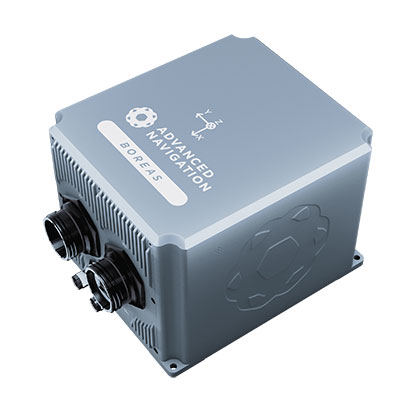
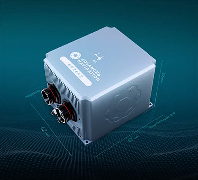
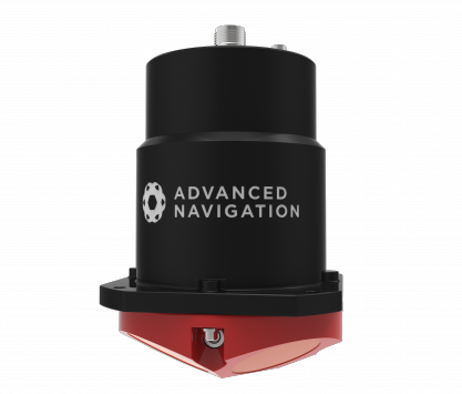
The D70 is the latest release in the Boreas digital FOG (DFOG) series, offering a new performance grade with superior accuracy, exceptional stability and reliability. The technology is suited to surveying, mapping and navigation across subsea, marine, land and air applications.
“We are thrilled to expand the Boreas series with the D70. It’s a system that will provide additional flexibility in the Boreas family, making ultra-high accuracy inertial navigation far more affordable than with previous FOG INS systems,” said Xavier Orr, CEO and co-founder of Advanced Navigation. “This patented technology opens the possibility for adopting FOG INS systems across a much broader range of vehicular applications, particularly autonomous vehicles and aircraft where weight and size are at a premium.”
Boreas D70 combines closed-loop DFOG and accelerometer technologies with a dual-antenna real-time kinematic (RTK) GNSS receiver. These are coupled with Advanced Navigation’s artificial-intelligence-based fusion algorithm to deliver accurate and precise navigation.
The system features ultra-fast gyrocompassing, acquiring and maintaining an accurate heading under demanding conditions. While the D70 does contain a GNSS receiver, it is not required for gyrocompass operation.
Based on the company’s DFOG technology, the D70 delivers a 40% reduction in size, weight, power and cost (SWaP-C) when compared to systems of similar performance.
0.01° roll and pitch
0.1° secant latitude heading (gyrocompass)
0.01°/hour bias instability
10 mm position accuracy
The Boreas Series
The Boreas DFOG series features ultra-fast gyrocompassing and can acquire heading, either stationary or dynamically, in less than two minutes. The gyrocompassing allows the system to determine a highly accurate heading without any reliance on magnetic heading or GNSS.
The technology stems from Advanced Navigation’s artificial intelligence sensor-fusion algorithm allowing the system to extract significantly more information from the data. It is designed for control applications, with a high level of health monitoring and instability prevention to ensure stable and reliable data.
Advanced Navigation designed Boreas from the ground up for reliability and availability. The hardware and software are designed and tested to international safety standards and have been environmentally tested to MIL-STD-810. The system achieves a mean time between failure (MTBF) of more than 70,000 hours.
Additional features of the Boreas D70 include Ethernet, CAN and NMEA protocols, as well as disciplined timing via a PTP server and 1 PPS. An embedded web interface provides full access to all of the device’s internal functions and data. Internal storage allows for up to 1 year of data logging.
About DFOG Technology
DFOG is patented technology, which has been developed over 25 years involving two research institutions. DFOG was created to meet the demand for smaller and more cost-effective FOGs, while increasing reliability and accuracy.
The first generation of FOG, made available in 1976, used analog signals and analog-signal processing. The second generation was developed in 1994 and is still used to this day. It improved upon the first generation with a hybrid approach using an analog signal in the coil with digital signal processing.
In 2021, FOG evolved into DFOG. This third generation of FOG sets itself apart by being completely digital, providing higher performance and reliability while enabling a 40% reduction in SWaP-C.
To achieve this, three different yet complementary technologies have been developed to improve the capabilities of FOG.
Digital Modulation Techniques. DFOG uses a specially developed digital modulation technique passing spread spectrum signals through the coil. The new digital modulation technique introduced in DFOG technology allows in-run variable errors in the coil to be measured and removed from the measurements. This makes DFOG significantly more stable and reliable than traditional FOGs. It also allows a smaller FOG with less coil length to achieve the accuracy of one with a longer coil.
Revolutionary Optical Chip. By integrating five sensitive components into a single chip and removing all the fiber splices, the size, weight and power are reduced considerably while significantly improving reliability and performance.
Specially Designed Optical Coil. DFOG employs a specially designed closed-loop optical coil, developed to take full advantage of the digital modulation techniques. The design allows for optimum sensing of in-run variable coil errors using the new digital modulation technique. It also provides a very high level of protection for the optical components from shock and vibration.
Vai Photonics was founded in Canberra in 2021 by physicists Lyle Roberts (left) and James Spollard to commercialize their research at Australian National University. ANU Vice Chancellor Brian Schmidt is at right. (Photo: Vai Photonics)
Advanced Navigation has acquired Vai Photonics, a spin-out from Australian National University (ANU) developing patented photonic sensors for precision navigation.
Vai Photonics’ vision, to provide technology to drive the autonomy revolution, is similar to Advanced Navigation’s. It will join Advanced Navigation in commercializing its research into autonomous and robotic applications across land, air, sea and space.
“The technology Vai Photonics is developing will be of huge importance to the emerging autonomy revolution,” said Xavier Orr, CEO and co-founder of Advanced Navigation. “The synergies, shared vision and collaborative potential we see between Vai Photonics and Advanced Navigation will enable us to be at the absolute forefront of robotic- and autonomy-driven technologies. Photonic technology will be critical to the overall success, safety and reliability of these new systems.”
James Spollard, CTO and co-founder of Vai Photonics, explained the technology. “Precision navigation when GPS is unavailable or unreliable is a major challenge in the development of autonomous systems. Our emerging photonic-sensing technology will enable positioning and navigation that is orders of magnitude more stable and precise than existing solutions in these environments. By combining laser interferometry and electro-optics with advanced signal-processing algorithms and real-time software, we can measure how fast a vehicle is moving in three dimensions. As a result, we can accurately measure how the vehicle is moving through the environment, and from this infer where the vehicle is located with great precision.”
The technology, in development for more than 15 years at ANU, will solve complex autonomy challenges across aerospace, automotive, weather and space exploration, as well as railways and logistics.
Aircraft with an electric vertical-takeoff-and-landing system such as flying taxis will greatly benefit from this technology, according to Advanced Navigation. Landing and takeoff are often considered the most dangerous and expensive part of a flight route. Vai Photonics sensors will provide safe and reliable autonomous takeoff and landings under all conditions.
Space travel and exploration is fraught with risks, vast complexity and enormous cost. This technology will bring massive benefits to space missions, helping to cement Advanced Navigation as the gold-standard for space-qualified navigation systems for space exploration.
“The work that underpins Vai Photonics’ advanced autonomous navigation systems stems from the search for elusive gravitational waves — ripples in space and time caused by massive cosmic events like black holes colliding,” said Brian Schmidt, vice-chancellor of ANU. “The team have built on a decade of research and development across advanced and ultra-precise laser measurements, digital signals and quantum optics to build their innovative navigation technology.”
This image shows the effect of increased elevation on surface area and obstacle avoidance. (Image: Advanced Navigation)
By Simon Harris, Advanced Navigation
Lidar-based surveying is increasing in demand across a range of industries. Recent market analyses indicate that lidar surveying is a multi-billion dollar industry that is expected to deliver sustained growth for years to come. As lidar technology matures and performance increases, its range of use is broadening into surveying more complex and difficult terrain or at speeds and in environments previously unsuited to such technology. Naturally, increasing diversity and performance brings about demands for greater reliability, speed and accuracy whilst remaining within physical and regulatory limitations.
Keeping pace with market demands in UAV and rail sector lidar surveying is increasingly challenging and requires an evolving synthesis between the acquisition and processing of lidar and GNSS-INS georeferencing data. Companies such as Cordel and its subsidiary Nextcore are taking advantage of the latest technologies to develop systems that are setting new benchmarks in these sectors.
Benefits of Altitude, Faster Lidar and Precision INS
UAV lidar surveying is capable of high-resolution surveys of complex terrain, vegetated areas and in light conditions that may be unsuitable to photogrammetry. These qualities make it a preferred option in many applications. However, it must remain cost-competitive with alternative solutions to become widely adopted by the surveying industry.
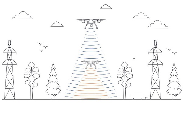
Typical UAV lidar surveying is performed at ~40m AGL. This altitude commonly presents collision risks with terrain and vegetation and imposes limits where the topography changes dramatically, such as voids that increase AGL beyond acceptable limits. Higher altitude surveying, therefore, offers obvious advantages, but also deeply challenges lidar sensors and the INS. Any mismatch in operational performance and accuracy between these inevitably degrades survey quality and severely limits use of the system.
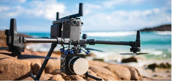
Nextcore accepted the challenge and set about developing a viable solution that could maintain a point cloud density of 200-500 points per m2 from a target altitude of 70 m. This equates to generating lidar point cloud data at millions of points per second. Achieving this required a GNSS-INS that provided suitably precise georeferencing data. Because survey data is derived from a source that is in constant motion in 3D space, the capability of the GNSS-INS is paramount in producing a digital twin of value and is critical to mission success.
After testing and evaluating various INSs from different manufacturers, Nextcore coupled its lidar with Advanced Navigation’s MEMs-based Certus Evo INS, which provides near-FOG performance and has a drift rate of 0.2 degrees/hour. This combination yielded exceptional results that allowed them to vastly extend the altitude ceiling to 120m while retaining consistent, accurate survey data.
“Operation at this altitude not only reduces the risk of collisions with trees, it enables surveyors to cover larger areas, greatly improving the solution’s efficiency,” said Ashley Cox, founder and COO of Nextcore.
Higher altitudes tend to increase the lidar swath width. The typical swath width at ~50m altitude is ~120m, depending on actual altitude and the resulting angle of incidence of lidar toward the edges of the swath. At 120m, a reliable swath width of 180m was achieved. This is a 50% increase over previous, equating to approximately 33% fewer flight-lines to survey a given area — a notable boost for productivity and efficiency to surveyors.
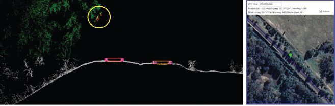
Example of rail track lidar showing encroaching vegetation, with associated map and location information. The yellow circle in the lidar data shows vegetation that is starting to intrude into the train’s path. (Images: Advanced Navigation)
Payload minimization also was a critical aspect in the search for an INS, as surveyors are always seeking longer flying time. This only can be achieved with a lighter technology stack payload. The team used an OEM version of the INS for a smaller form factor that could be integrated within a single ruggedized housing. This allows a design with greater strength, weather resistance and efficient payload setup.
“The industry is constantly seeking lighter payloads for longer flight times and to fit on smaller, safer UAVs,” Cox said. “Regulatory restrictions challenge the industry to meet certain specifications. The same is true for UAV lidar. We hit a ceiling. We need to be able to improve on that, although what we’re achieving now is a real game changer.”
The resulting survey material contains lidar point cloud data and the geo-referencing data from the INS. All data processing is performed post-flight to ensure the highest possible accuracy. PPK is used for correction of GNSS-INS position, roll, pitch and heading data. The processed INS data is then combined with the processed point cloud data to provide absolute position to the point cloud. This system realized consistent 30~40mm precision at 120m AGL. Nextcore has integrated the lidar and INS processing platforms to automate the synthesis of data sets, reducing the survey completion time. Depending on the survey’s size and complexity, this solution can process survey data into a 3D map within 30 minutes of mission completion.
Nextcore used a Certus Evo GNSS receiver, which internally uses the u-blox ZED-F9P chip. It logs GPS L1, L2, GLONASS L1, L2, Galileo GalE1, E5, and BeiDou B1, B2 frequencies at 8 Hz. It used the Kinematica correction service running a PPK filter.
Lidar sensors have become light enough to mount on UAVs (Photo: Advanced Navigation)
Scanning Rail Corridors Super Fast
Aerial surveying is not the only environment to present challenges to lidar and INS.
Train-mounted lidar for automated track and rail corridor surveying is another burgeoning market. This application typically uses lidar and position data to detect and identify areas of the railway that require maintenance and, perhaps more importantly, preventive maintenance. Rail surveying presents unique demands, including operating at speeds of 160km/h (100mp/h) or more, maintaining position accuracy during GNSS outages and variable environmental conditions.
Land-based surveying provides flexibility for selecting an INS compared to aerial applications, as size and weight are usually irrelevant. Rail surveying also requires an INS that provides the necessary performance while tolerating vibration and erratic movement from junctions, points and signals, and be absolutely dependable in GNSS-denied situations. Cox’s team found that the greater accuracy and better drift stability of FOG INS over MEMS provided an ideal platform for generating reliable and accurate paths of train trajectory.
Cordel tested Advanced Navigation’s Boreas digital FOG INS as a potential solution. Testing was carried out using cars as a simulation, travelling complex routes in two directions then overlaying the lidar point clouds to check for discrepancies or unsynchronized areas. The results provided the confidence to put the Boreas into service.
Railways typically traverse deep cuttings, lengthy tunnels and other environments that disrupt GNSS. It is mission-critical that the INS can apply dead reckoning the instant GNSS is disrupted and maintain accurate position for the entirety of the outage. Reliable path and location data during GNSS disruptions is central to the viability of automated rail surveying. Blind spots or zones of unreliable route data cannot be tolerated by rail operators from safety, track availability and financial perspectives.
The Cordel AI lidar analysis system can be “tuned” to the required metrics and is capable of self-learning. The AI enables the system to pre-emptively identify and flag areas of concern before they become an actual problem or hazard. Examples include measuring track gauge and alignment, ballast distribution and coverage, and clearance between potential hazards to the train. The entire route is logged, creating a “Google map” of the railway that maintains a historical record of survey data each time the track is used.
Clients can then view a representation of the lidar data to get a clear understanding of any issues and how to respond before sending personnel or assets to a location. This enables intervention before safety is compromised or remedial works become large-scale and disruptive. As a result, rail service providers can maintain safer railways, deliver more reliable services, and minimize operating costs.
Advanced Navigation has launched a new fiber-optic gyroscope inertial navigation system (INS), named Boreas. It is an ultra-high accuracy, strategic-grade INS, offering a reduction in size, weight, power and cost. Boreas is the first product to be released based on Advanced Navigation’s new DFOG (digital fiber-optic gyroscope) technology, which is the culmination of 25 years of development involving two research institutions.
The Boreas is targeted at applications requiring always-available, ultra-high accuracy orientation and navigation including marine, surveying, subsea, aerospace, robotics and space.
“Boreas is the first product on the market to offer our patent-pending DFOG technology,” said Advanced Navigation CEO Xavier Orr. “DFOG represents a step-change for fiber-optic gyroscopes. With Boreas’ ultra-high-accuracy and strategic-grade performance combined with the reduction of size, weight, power and cost by 40%, we will be able to enable new industries and applications that were never possible before.”
The Boreas delivers strategic-grade bias stability of 0.001 deg/hr. This allows it to achieve ultra-high roll/pitch accuracy of 0.005 degrees and heading accuracy of 0.006 degrees. Boreas allows for full independence from GPS with dead-reckoning accuracy of 0.01% distance traveled with an odometer or Doppler velocity log.
The Boreas features ultra-fast gyro compassing, taking only 2 minutes to acquire heading in both stationary environments or on the move. Gyro compassing allows the system to determine a highly accurate heading of 0.01 degrees secant latitude without relying on magnetic heading or GPS.
The Boreas contains Advanced Navigation’s sensor-fusion algorithm, which is more intelligent than the typical extended Kalman filter. The algorithm is able to extract significantly more information from the data by making use of human-inspired artificial intelligence. It was designed for control applications, with a high level of health monitoring and instability prevention to ensure stable and reliable data.
Advanced Navigation designed Boreas from the ground up for reliability and availability. Both the hardware and software are designed and tested to safety standards, and it has been environmentally tested to mil standards.
The system is designed for a mean time between failures of 500,000 hours. Additional features include Ethernet, CAN and NMEA protocols, as well as a disciplined timing server providing PTP. An embedded web interface provides full access to all of the device’s internal functions and data. Internal storage allows for up to one year of data logging.
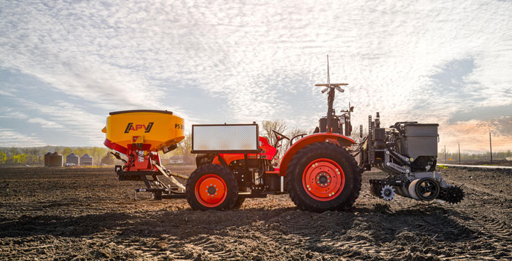
Intelligent navigation-based automation is redefining the farmer’s humble tractor to robotic status. This results in significantly faster field preparation and cropping and dramatically reduced labor costs.
Any autonomous vehicle requires the highest levels of navigational accuracy, control and safety. For farming applications, this typically means maintaining exact heading at very low speeds, often over bumpy terrain. These requirements make using the right navigational equipment critical to success. The key challenge is maintaining precise placement and movement of the tractor relative to crop rows and field boundaries. Failure to maintain precision can cause rows to be damaged or planted seedlings to be uprooted. The typical accuracy required for precision farming is position to within a decimeter (10 cm) — well beyond basic GNSS. This requires real-time kinematic (RTK) positioning and advanced signal processing.
Sabanto, a U.S.-based farming as a service (FaaS) start-up, was facing this exact challenge. The company needed a precise and reliable navigation solution for its fleet of driverless tractors deployed in a growing number of U.S. states, including Illinois, Iowa, Nebraska and Minnesota.
“The reliability of Advanced Navigation’s GNSS Compass gave us the peace of mind required to operate fully autonomously from Spring to Fall of 2020,” explained Craig Rupp, CEO of Sabanto.
Thanks to its dual-antenna GNSS and RTK corrections, the GNSS Compass can offer high-accuracy heading. Accurate position is maintained using real-time correction data, delivered from nearby ground base stations, resulting in near-centimeter accuracy under the most demanding conditions.
Furthermore, the GNSS Compass includes an integrated inertial navigation system (INS) to ensure consistent position accuracy of the tractor in the event of degraded or lost signals from GNSS satellites from heavy canopy or steep terrain. Roll, pitch and heading data also improve the stability of the autonomous platform over difficult terrain.
Sabanto engineers can now deploy and remotely monitor their fleet of autonomous tractors 24/7. Operators can simply pre-program the itinerary and field boundaries, as well as when to lift and lower tillers, resulting in the tractors planting up to two hectares (five acres) per hour.
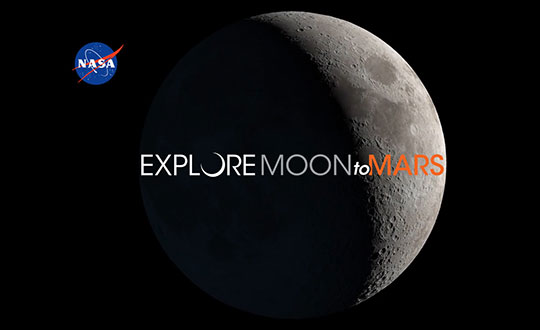
Advanced Navigation, in partnership with quantum technology company Q+CTRL, will create a quantum-enhanced inertial navigation solution for space launch vehicles, satellites and landers. The design of this inertial navigation technology for long-endurance space missions will be pivotal to NASA’s space exploration initiative, the Artemis Lunar Exploration Program.
The work will be done under a Moon to Mars Supply Chain Capability Improvement grant by the Australian federal government.
The quantum-enhanced navigation system will enable NASA and its partners in the international space exploration community to execute deep space, lunar and planetary missions that were previously not possible.
Artemis is NASA’s human lunar exploration plan, with the program aiming to send the first woman and next man to the surface of the Moon by 2024. Scientists have long acknowledged the Moon as a rich source of information regarding Earth and the Solar System. Using the findings from the Moon. NASA will then prepare to launch missions to Mars.
To meet NASA’s space exploration initiatives, high-end, highly accurate inertial navigation technology is vital to the mission’s success. The groundbreaking inertial navigation systems developed by Advanced Navigation have been recognised by the international aerospace community as a superior technology to help pioneer a new age of space exploration and discovery for humanity.
For Advanced Navigation, this is just the beginning. “In the long-term view of this critical initiative, team activities following this project will establish an ongoing manufacturing opportunity and capacity that is central to the emerging Australian space industry,” said Chris Shaw, co-CEO of Advanced Navigation.
Advanced Navigation was founded in Sydney in 2012 by engineers Xavier Orr and Chris Shaw to commercialize thesis research into AI neural network-based inertial navigation. The first product met the market with great success and the company expanded rapidly adding a portfolio of navigation offerings and moving into a diverse range of deep tech fields such as underwater acoustics, GPS, radio frequency systems, sensors and robotics.
Today Advanced Navigation is a supplier to companies including Airbus, Boeing, Tesla, Google, Apple and General Motors. Advanced Navigation is headquartered in Sydney with a large research facility in Perth and sales offices around the world.
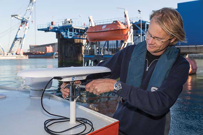
Advanced Navigation’s plug-and-play GNSS Compass was selected by Nortek for its new survey package. Nortek’s scientific instruments apply the Doppler principle to underwater acoustics to measure water in motion, such as currents and waves. The instruments are used by scientists, researchers and engineers worldwide, employed in demanding environments that require state-of-the-art instrumentation that is reliable and easy to use.
A vessel-mounted acoustic Doppler current profiler (ADCP) measures the velocity of currents beneath a moving vessel. To correct the measured values for vessel speed and direction, ADCP measurements require accurate velocity and heading information. Besides the use of bottom track within the ADCP itself, such information can be provided externally using a GNSS receiver and a non-magnetic heading source such as a gyro compass.
Nortek’s ADCP package — Signature VM — offers operational convenience and reduced complexity. As part of the package, Advanced Navigation’s GNSS Compass provides accurate dual-antenna GNSS-based heading that is not subject to magnetic interference. Its inertial navigation system (INS) can maintain accurate heading during GNSS outages of up to 20 minutes. “By making use of today’s modern Ethernet instruments, such as the Signature ADCP and the GNSS Compass, we can guarantee nanosecond time synchronization with Ethernet PTP protocol,” said Herman Huitema, VM product manager at Nortek. “Data from the ADCP can be exactly aligned with the GNSS Compass information.”
Advanced Navigation has released its GNSS/INS post processing software Kinematica.
Kinematica is designed to be an easy-to-use GNSS/INS post-processing software that allows users to process raw GNSS and inertial data after collection and achieve higher accuracy position, velocity and orientation than is possible in real time.
Kinematica has been released as free software with a time lock to Aug. 1, 2016.
The software supports kinematic GNSS positioning, which provides a 200x increase in position accuracy over standard GNSS with 8-mm position accuracy. Dual antenna GNSS heading processing is also supported.
Kinematica processes data in forward and reverse six times, which allows it to fill any satellite outages and ignore errors that would normally affect a real-time solution. Both loosely and tightly coupled GNSS/INS processing is supported and the software automatically switches between each mode depending upon the environment.
Kinematica supports all of Advanced Navigation’s GNSS/INS products. Support for a wide range of third-party systems is scheduled for the next update in July.
Kinematica is targeted at surveying, scanning and aerial photography applications that need to squeeze the maximum performance out of their systems.
The Sublocus underwater inertial navigation system by Advanced Navigation features high-accuracy north-seeking fiber-optic gyroscopes and accelerometers with a GPS receiver and pressure depth sensor, fused to deliver positional accuracy of 0.08 percent of distance traveled. The system also provides highly accurate roll, pitch, heading, heave, depth, and altitude.
Sublocus is also available with an integrated RDI Workhorse Navigator DVL for combined acoustic and inertial navigation in the one product. Both models are supplied with a subsea GPS antenna and are rated to 3,000 meters depth.
Advanced Navigation, in collaboration with KVH Industries, has announced its new Spatial FOG GNSS/INS. Spatial FOG is a ruggedized GNSS-aided inertial navigation system and AHRS that provides accurate position, velocity, acceleration and orientation under demanding conditions. It combines the new KVH Industries 1750 fiber-optic gyroscope-based inertial measurement unit with magnetometers, a pressure sensor and a dual-frequency RTK GNSS receiver. These are coupled in a sophisticated fusion algorithm to deliver highly accurate and reliable navigation and orientation, the companies said.
Spatial FOG contains a dual-frequency RTK GNSS receiver that provides 1-centimeter accuracy positioning and supports all of the current and future satellite navigation systems, including GPS, GLONASS, Galileo and Compass.
A next-generation memory backup system allows Spatial FOG to hot start inertial navigation from its last position in 2 seconds and obtain a GNSS fix in as little as 3 seconds. The memory backup system lasts for the lifetime of the product and will provide backup for 24 hours without power.
Spatial FOG’s internal filter runs at 1,000 Hz, and data can also output at this rate over high speed RS232 or RS422. This allows for control of dynamically unstable platforms, the companies said. Spatial FOG is also highly tolerant to both shock and vibration thanks to the performance of the KVH 1750 IMU design and advanced filtering.
Spatial FOG supports a wide range of peripherals including external GNSS receivers, odometers, DVLs, USBLs and NMEA devices. It also supports both industry-standard NMEA output and a binary protocol. Spatial FOG also is easily integrated into retrofits or new designs, said Advanced Navigation.
Advanced Navigation, a developer of 3D navigation technologies, has launched its Spatial product series, featuring NVS Technologies AG’s NV08C-MCM high-performance multiple GNSS-constellation receiver.
The Spatial is a ruggedized miniature GNSS/INS & AHRS system that provides accurate position, velocity, acceleration and orientation under demanding conditions. It combines temperature calibrated accelerometers, gyroscopes, magnetometers and a pressure sensor with an advanced GNSS receiver. These are coupled in a sophisticated fusion algorithm to deliver accurate and reliable navigation and orientation, Advanced Navigation said.
The Spatial product line takes advantage of the NV08C-MCM’s multi GNSS constellation support, ensuring high availability of navigation signals, high sensitivity, providing reliability, accuracy and performance.
Advanced Navigation is a privately owned Australian company that specializes in the development of 3D navigation technologies. The company’s engineers come from a background in mission critical robotics built to military specifications.