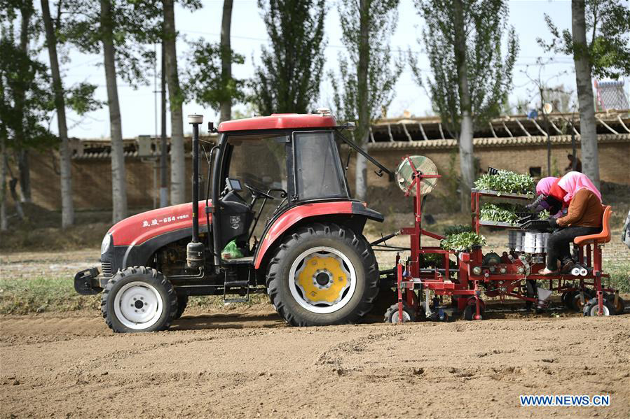
A self-driving tractor using the BeiDou Navigation Satellite System (BDS) was tested successfully March 10 in northwestern Tunisia, according to China.org.cn.
The representatives of China-Arab BDS/GNSS center and the Arab Information and Communication Technologies Organization (AICTO), as well as the academic staff of an engineering school in Mjez El-Beb region in northwestern Tunisia, attended the test ceremony.
The smart tractor, used in various agricultural activities, was equipped with a BDS receiver so that it could be controlled remotely without a driver.
“I am very impressed and surprised by the quality of the equipment offered by BeiDou,” said Sami Trimech, the strategic planning and development director at AICTO.
“We had a dream to bring BeiDou to the Arab countries,” said Nour Laabidi, the project manager at AICTO and head of China-Arab BDS/GNSS center in Tunisia.
“This is a pilot project. We are happy to implement it in our country and I hope that all Arab countries will be able to use this Chinese technology,” Laabidi said.
Hassan Kherroubi, a specialist in the mechanical industry at the Mjez El-Beb engineering school, stressed the contribution of this Chinese technology to the agricultural sector in Tunisia.
Agricultural activities, including harvest, will be more profitable and more effective with such technologies, according to Kherroubi.
“Our main concern is to benefit all Arab and African countries of this fruitful cooperation between Tunisia and China,” Kherroubi said, adding that this advanced technology will bring a bright future to the region.
BDS is compatible with other navigation systems, such as GPS, and users can receive services from both systems at the same time, improving positioning accuracy.
Esri has launched the Africa GeoPortal, a comprehensive cloud-based platform that provides rich content and solutions from Esri and its partners.
The geoportal provides access to Esri’s ArcGIS Online service as well as geographic data and imagery for Africa.
The African Union, African Development Bank, other international agencies, nongovernmental organizations (NGO), academia, businesses and national government funds will be able to use the geoportal to address the most urgent development challenges — from economic development and climate adaptation to conservation and health care.
“Access to this Africa GeoPortal powered by the ArcGIS platform will provide my colleagues at the iLab, and others in the network of African Technology Hubs (AfriLabs), with the information and analytical capabilities that we need to make the most effective development interventions for our citizens and communities,” said Luther Jeke, Manager of iCampus at iLab Liberia.
The complimentary software-as-a-service technology is offered to all who are supporting African nations for positive economic, social and environmental outcomes — African citizens, NGOs, and international development agencies alike.
The geoportal offers access to spatial analytics capabilities and authoritative content for charting compelling, educational, informational, entertaining and beautiful maps of Africa, Esri said.
“We are deeply committed to helping the people of Africa discover, explore, and understand the vast information available to them through the power of maps,” said Jack Dangermond, Esri founder and president. “Through this service, we hope to provide our users with the benefit of ongoing developments and investments at Esri so they can foster missions to the best of their abilities.”
To learn more about the Africa GeoPortal and Esri’s commitment to supporting the global community in the quest for sustainability through better mapping and location intelligence, visit go.esri.com/africa_geoportal.
Night and day: UAV patrols defend dwindling elephant and rhino populations.
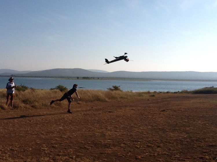
To stem the staggering wildlife losses on the African continent from poaching, the Air Shepherd Campaign is employing a force of unmanned aerial vehicles (UAVs) equipped with GPS and infrared cameras.
Teams on the ground, in close cooperation with wildlife reserve management organizations, use the UAVs and sophisticated predictive analysis to hunt the illegal hunters.
More than 40,000 elephants were killed by poachers in Africa in 2014.The problem is similar for rhinoceros.
Poachers operate at night, when park rangers equipped with conventional aircraft can’t fly. Air Shephard searches for poachers using predictive analysis to determine the behavior patterns of both animals and poachers. Small drones with cameras search likely areas — once poachers are identified, pre-positioned rangers can intercept the suspects.
The hand-launched UAVs carry high-resolution cameras for both daylight and nighttime infrared scanning. At operating altitude, they can easily tell the difference between animals and humans, and transmit real-time geolocation information to the operating team on the ground. The UAVs fly for more than 1.5 hours; they are clean, stealthy and provide an eye-in-the-sky capability.
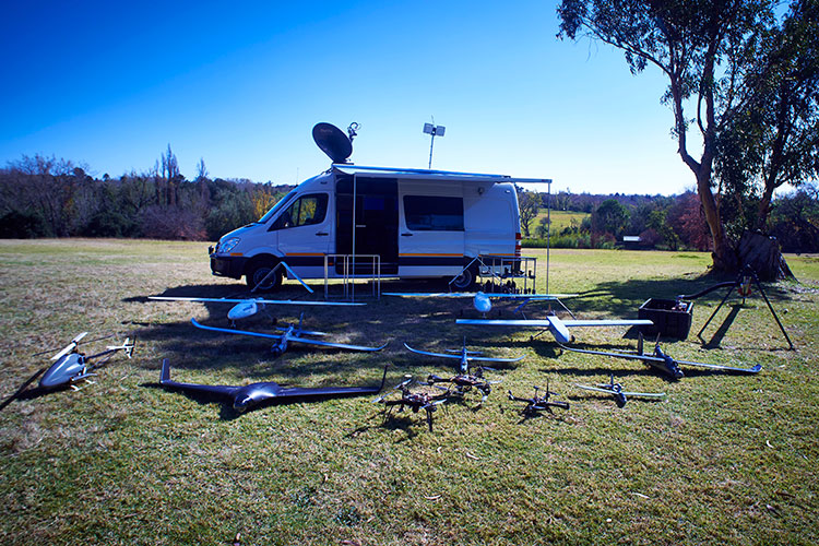
UAV fleet deployed around an Air Shepard mobile operating center.
The Charles A. and Anne Morrow Lindbergh Foundation, originator of the Air Shepherd Initiative, has partnered with a dedicated group in South Africa that, over the last two years, has flown more than 650 drone missions over one of the most sensitive rhino poaching areas in Africa. During that period, no rhinos were lost to poachers where the UAVs were flown.
Once the process is proven, Air Shepherd expects it to be used in national parks and private reserves in South Africa and Botswana, then expand as funding increases to Namibia, Zambia, Tanzania, Gabon, Democratic Republic of the Congo, and eventually Asia.
Jane Goodall and the Jane Goodall Institute have launched the Tapestry of Hope, an interactive online tool to visualize the thousands of projects led by young people around the globe who are protecting the environment.
As world leaders struggle to make progress in Paris for the 21st Conference of the Parties to the United Nations Framework Convention on Climate Change, Goodall, spreading her message of hope for our world, is calling on each of us to take action ourselves to protect our natural world.
Founder of the Jane Goodall Institute and UN Messenger of Peace, Goodall, through her Roots & Shoots program, has inspired hundreds of thousands of people around the globe to take action to make the world a better place for people, animals and the environment. Together, these individual actions weave together a story of impact — a narrative of change for what Goodall has come to call the Tapestry of Hope.
The launch of Tapestry of Hope reflects a snapshot of the projects young leaders have led in the past several years through Roots & Shoots,” said Erin Viera, associate vice president of Roots & Shoots. “Moving forward, the map will be a critical tool to document, manage, visualize and share the actions and impacts of Roots & Shoots projects that are making a positive difference for the environment, animals and people. The map will continue to grow and populate with the launch of each new Roots & Shoots community project that young people continue to pioneer around the world.”
“Esri and the Jane Goodall Institute have collaborated on conservation programs across Africa for more than 10 years now. These projects have included applications ranging from using geospatial technologies for chimpanzee behavior research in Gombe to supporting the development and implementation of conservation action plans and improving village land use using geodesign and community mapping across East Africa and Congo basin,” said Lilian Pintea, the Jane Goodall Institute’s vicepresident of conservation science.
Esri technology that powers the mapping behind JGI’s conservation work forms the basis of the Tapestry of Hope. The map connects the work of young people around the world with other young people who are passionately making the world we all share a better place through local projects.
In addition to documenting and visualizing the work of young people around the world, the Tapestry of Hope map serves to further Goodall’s message of hope. It brings together the critical observations, creative ideas and clever solutions of thousands of passionate young minds all working to make a difference in the world. It is designed to represent and inspire a global movement of change showing that young people care about the future of the world they are inheriting, and are taking action.
VisionMap’s A3 Edge Digital Mapping System was recently used to map wildlife in an African national park. A3 Edge provides an efficient solution for detecting, tracking and estimating wildlife populations, according to maker VisionMap.
The A3 Edge camera surveyed the park from an altitude of 4,000 ft. above ground level (AGL), capturing 3.5 cm resolution imagery at a rate of 225 km2/ hour. A3 Edge uses a “sweep” capture technology that provides quick, high-resolution coverage of vast areas.
Among the animals identified in the images were antelopes, elephants, hippopotamuses and giraffes. The animals’ locations are clearly visible in the aerial images, and the automatic object recognition capability available with VisionMap systems makes it easy to calculate the number of animals in a particular area.
VisionMap’s LightSpeed processing system automatically processes VisionMap images, producing aerial triangulation, orthophoto, digital surface model (DSM), 3D models, and georeferenced vertical and oblique images. The system’s fast turnaround time makes it possible to regularly survey the area, and collect useful information about the animals’ behaviors and trends, VisionMap said.
LizardTech, a provider of software solutions for managing and distributing geospatial content, has expanded its global presence with several new business partnerships and product purchases during the first half of 2015.
During the last six months, national governments, energy organizations and infrastructure owners and operators have all bought LizardTech software in countries such as Canada, Sweden, Norway, Germany, United Kingdom, Spain, South Africa, Saudi Arabia, Turkey, Oman, Australia and the Philippines.
“We are delighted with the progress we have made in promoting LizardTech’s remarkable MrSID-based software throughout the European, African and Middle Eastern market places and beyond into Asia Pacific,” said Quarry One Eleven Founder Alistair Maclenan. “LizardTech is a great client that understands the power of marketing and in-region representation. Their support has been a huge factor in the partnership and sales successes we have seen for their image compression, preparation and distribution products.”
“We have had an exciting first half of the year which illustrates that our products are in demand all over the world,” said Jeff Young, who directs Global Business Development at LizardTech. “These sales validate the sustainability of LizardTech over the last 23 years through partnerships in multiple continents. We take pride in our customer’s loyalty and continued commitment to our MrSID image compression format.”
GIS map provider Mapmechanics has boosted the number of African countries for which it offers HERE vector (scalable) map data.
HERE mapping from Mapmechanics consists of street-level vector map and includes major highways, main roads and also some minor roads and city streets, and is useful for route planning, drive-time analysis, vehicle tracking and geo-demographics. A key feature of the data is that its structure is consistent across many countries, enabling users to adopt the same analytical and display strategies from one country to another.
The new African countries added to the Mapmechanics portfolio are Cameroon, Cape Verde, Central African Republic, Chad, Democratic Republic of the Congo, Equatorial Guinea, Ethiopia, Gabon, Guinea-Bissau, Republic of the Congo, São Tome and Principe.
Because it is in a standard and widely recognized format, the mapping lends itself well to use with other data such as traffic speed and density where this is available. It can also be used for techniques such as reverse geocoding (finding a location by its coordinates).
The mapping also enables users to add a sense of place to activities such as geo-demographic studies, store location analysis, leaflet distribution territories or depot management, and ensures that users can overlay just the features they need on shaded maps.
Mapmechanics already offers HERE mapping for many of the more prominent African countries, including for instance Botswana, Egypt, Kenya, Mozambique, South Africa and Tunisia. Altogether around two dozen African countries are now covered, and more will be added in future.
HERE mapping is just one of a wide range of mapping products offered by Mapmechanics for the UK and the world, all of which can be obtained directly from the company or through its transactional website.
Avanti Communications has been appointed by the UK Space Agency to deliver a crucial air navigation project in Africa, SBAS-AFRICA. The satellite operator has been awarded the contract under the agency’s International Partnership Space Programme (IPSP), which exists to open up opportunities for the UK space sector to share expertise in real-world satellite technology and services overseas.
Africa has just 3 percent of global air traffic, and yet air accidents in Africa account for roughly 20 percent of the worldwide total. By demonstrating potential improvements in flight safety via SBAS technologies, the project can provide socio-economic benefits to the continent, according to a news release from Avanti.
Based on prior cost-benefit modeling which identified a €1.7 billion potential economic benefit to the African aviation sector from the deployment of SBAS services, SBAS-AFRICA will help accelerate the adoption of GNSS-based flight operations, positively influence the evolution of aviation safety in Africa and encourage development in the wider African economy.
SBAS-AFRICA will deliver a satellite-based augmentation system for GNSS-based operations in the aviation sector, serving significant parts of Africa in partnership with a number of local stakeholders. The project will use a unique asset, Avanti’s ARTEMIS L1 Navigation transponder, to provide a navigation data broadcast service.
“SBAS-AFRICA brings an innovative and pragmatic approach to deploying SBAS services in Africa,” said Matthew O’Connor, Chief Operating Officer at Avanti Communications. “It establishes crucial collaboration between the UK and a number of African countries, including South Africa and Ghana. Participating countries will benefit hugely from expertise gained, placing them at the forefront of navigation services across the continent and, crucially, helping to improve aviation safety for a major generator of economic benefit in Africa.”
He continued, “The Artemis satellite will play an integral role in this project. We expect that such a showcase for its performance, accuracy and quality will provide further evidence of what can be achieved with this technology and lead to significant commercial opportunities.”
“The UK Space Agency is delighted to play a role in fostering new international partnerships that not only enable innovative UK space companies like Avanti to provide more high-tech exports that can boost our space sector but also allow the UK to widely share the considerable social and economic benefits that space technology and infrastructure can provide,” said David Parker, chief executive of the UK Space Agency.
SAFIR is part of the Africa-EU long-term strategic partnership to enhance safety in air transport. Its global objective is to build capacity within African ACP countries for the future deployment of GNSS/EGNOS in the region. The three-year project is funded by the European Union and financed from the 10th EDF Intra ACP envelope with 3.7 million euros, under an international consortium led by ASECNA (Agence pour la Sécurité de la Navigation Aérienne en Afrique et à Madagascar) with Egis, Pildo Labs and ESSP.
The ceremony took place in Dakar on March 3. Those attending included Matthias Petschke, EU Satellite Navigation Programmes director; Karolina Stasiak from the UE Delegation in Sénégal; and Amadou Ousmane Guittèye, director general of ASECNA.
“Satellite navigation can bring huge societal benefits, be it in transport, in agriculture or land management,” Petschke said in remarks at the launch ceremony. “Satellite-based augmentation systems in particular, like EGNOS, can bring enormous social and economic benefits. I attach, therefore, great importance to the setting up of the EGNOS Africa Joint Programme Office and am particularly pleased to see this team of African experts who have extensive experience and knowledge to support the development of an African satellite based augmentation system.”
In his speech, Guittèye said, “The first mission of the JPO is to ensure Africa has developed adequate competencies and then to coordinate the implementation of the development and of the deployment of GNSS/EGNOS services and applications in the continent. The EGNOS-Africa Joint Programme Office (JPO) is a pan-African entity that acts for the benefit of Africa and supports stakeholders in their GNSS/EGNOS strategy, developments and implementation.”
The ceremony also was attended by officials from the International Civil Aviation Organisation (ICAO), the African Civil Aviation Commission (AFCAC), the Agence Nationale de l’Aviation Civile et de la Météorologie (ANACIM) , the Aéroports du Sénégal (ADS) and local authorities.
The SAFIR project began on January 15, 2013. It covers the set-up, staffing and operations of an EGNOS-Africa Joint Programme Office, and sets up and supports a number of technical working sessions composed of regional stakeholders concerned with GNSS/EGNOS in sub-Saharan Africa.
ASECNA has 18 member states. With air navigation safety as its main mission, it cooperatively manages African airspace for the countries of Benin, Burkina Faso, Cameroun, Central African Republic, Comoros, Congo, Côte d’Ivoire, France, Gabon, Guinea Bissau, Equatorial Guinea , Madagascar, Mali, Mauritania, Niger, Senegal, Chad and Togo.
Esri announced that the Strauss Center’s Climate Change and African Political Stability (CCAPS) program has implemented Esri technology to view how climate change impacts vulnerable populations in Africa. CCAPS created the dynamic mapping tool in partnership with AidData for use by researchers, policy makers, journalists, and citizens. Users can visualize any combination of CCAPS data on climate change, conflict, and aid on a map to discover how different forces overlap or intersect.
“This mapping tool allows policy makers to analyze data from multiple sources at once, providing integrated analysis of the drivers and responses related to security risks stemming from climate change,” said Francis J. Gavin, director of the Strauss Center.
According to the announcement, the tool is already being used in the country of Malawi for a solution that tracks and reports on the country’s external funding. Aid information is mapped along with data on climate change vulnerability and incidents of conflict. This sheds light on whether aid is effectively targeting regions where climate change or conflict poses the most significant risk to the sustainable development and political stability of the country.
“Climate change poses an enormous threat to the livelihoods of millions of Africans,” said Jean-Louis Sarbib, CEO of Development Gateway. “The level of risk, however, is not evenly spread and certainly doesn’t respect national boundaries. To ask critical questions about how development assistance can reduce vulnerability, you need hyperlocal data on climate and also on aid-funded interventions. This is what the new CCAPS mapping tool shows in a digestible, interactive way.”
Esri reported that by integrating CCAPS research on climate change, along with existing datasets such as topographic maps, imagery, and thematic information on conflicts, the CCAPS mapping tool aims to provide the most comprehensive view possible of climate change and security in Africa.
“The great work of these organizations is a real game changer for the development community,” said Jack Dangermond, president of Esri. “Being able to create a tool that allows people to communicate with others all over the world using maps is powerful. I am impressed with the work being done and excited to see what they will think of next.”
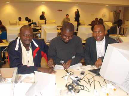
Workshop participants from Cote d’Ivoire and Kenya assemble a Mindstorm robot to trial autonomous navigation.
By Patricia Doherty
Last year I helped coordinate a three-week workshop for 50 scientists from 15 African countries, introducing the basics of GPS for applications with socioeconomic benefits and scientific exploration. Held in Trieste, Italy, the workshop was quite successful, producing new initiatives on the African continent. We repeat the workshop next month, April 6–24, again in Trieste.
Since the 2009 training, regional GNSS workshops have taken place in Nigeria, Egypt, Kenya, and Ethiopia. We have initiated scientific collaborations with universities in Nigeria, Kenya, Zambia, Egypt, and Uganda, deploying GPS receivers at each institution, with the understanding that the data will ultimately be shared within Africa and the world.
This effort is a way to share with Africa and Africans the wealth that GNSS has brought to the developed world.
Africa’s 2006 Science and Technology Plan of Action states Africa’s commitment to develop and use science and technology for socio-economic transformation and full integration into the world economy. The leading problems that continue to cripple much of Africa include hunger, extreme poverty, erosion of natural resources, and natural disasters. GNSS can help address these problems and ultimately meet the plan’s goals. Specifically, GNSS applications can increase food security, manage natural resources, provide efficient emergency location services, improve surveying and mapping, and provide greater precision and safety in land, water, and air navigation systems. GNSS also has applications in scientific study including space weather, geophysics, geography, geology, ecology, and biology.
Workshop participants included professors and graduate students from Cote d’Ivoire, Egypt, Ethiopia, Ghana, Kenya, Morocco, Nigeria, Uganda, and Zambia. The more than 25 lecturers came from the United States, Europe, and Africa.
The workshop integrated formal lectures with hands-on practice in GNSS architecture, signal structure, hardware design, state-of-the-art applications, and scientific exploration. An on-site computer laboratory enabled participants to perform positioning calculations; use mapping and surveying software; plan a precision farming procedure; and analyze atmospheric and ionospheric data — all from GPS measurements. In addition, participants built Lego Mindstorm robots to demonstrate autonomous navigation.
One of the benefits of this program was that scientists and engineers from the United States had opportunities to discuss common interests with African scientists and engineers. Many research programs utilize GPS ground- and space-based measurements. Unfortunately, studies over the African region have not been possible due to the lack of dependable long-term measurements. This workshop opened the door to establishing a base of measurements for joint studies with our African colleagues.
Many lecturers remarked that this was the most enriching teaching experience of their careers. The African participants said that they learned a great deal and were very appreciative of the opportunity to participate in this program.
Workshop sponsors include Boston College’s Institute for Scientific Research (where I work), the Abdus Salam International Center for Theoretical Physics in Trieste (where my colleague and workshop co-director Sandro Radicella is head of the Radiopropagation Laboratory), Institute of Navigation, Federal Aviation Administration, Air Force Research Laboratory, National Aeronautics and Space Administration, United Nations Office for Outer Space Affairs, National Science Foundation, Trimble, and NovAtel.
To learn more about the workshop, participate, or contribute, please contact Patricia.Doherty @ bc.edu