Topnet Live has increased types of correction services and subscription options. (Image: Topcon)
Topcon Positioning Group has expanded its Topnet Live GNSS network of correction solutions to support today’s work environments. The global network now has more types of correction services and subscription options.
This growth is a result of the increasing demand for digitalization in various industries including construction, surveying, machine control, and agriculture.
The flexible service options include Realpoint, the real-time kinematic (RTK) service, and Starpoint, a precise point positioning (PPP) service. The different services have varying delivery methods, coverage and reliable centimeter-level accuracy. Under a flexible subscription model, customers can purchase to suit their needs.
Additionally, Skybridge — an RTK service supported by PPP — is available to maintain connectivity and productivity if the customer temporarily leaves RTK coverage.
“The Topnet Live RTK network, first established over a decade ago, continues to grow with 5,100 reference stations globally, a 14% increase in the last year,” said Ian Stilgoe, Topcon vice president. “We are growing throughout the world in areas where there is an increasing demand for productivity and accuracy through digitalization, with strong growth particularly in North America and Europe. We are focused on continued expansion to maximize support for our customers, so they always have the best options globally.”
Original equipment manufacturers (OEMs) supplying automotive, industrial Internet of Things (IoT), autonomous robotics and all sectors that require positioning, navigation and guidance also benefit from the enhanced robustness of the network. OEMs can sell their hardware with correction services onboard and preconfigured for immediate use by customers, regardless of geographic location, with flexible subscription and licensing options to suit the exact need.
Topnet Live uses all four GNSS constellations: GPS, GLONASS, Galileo and BeiDou. The customer benefits from continuous accuracy and always-on service coverage. This service provides these distinct advantages in the industries it supports:
Survey, construction and machine control. Topnet Live removes the need for individual base stations, dramatically increasing flexibility, productivity and safety and can drive large-scale projects with constant, reliable accuracy.
Precision agriculture. The solution delivers fast, consistent, accurate positioning at any time day or night for soil preparation, seeding, spreading, spraying and harvesting.
OEMs, system integrators, product designers. The solution provides scalable precise positioning and supports the implementation of flexible business models tailored to fit both OEMs’ and their customers’ needs.
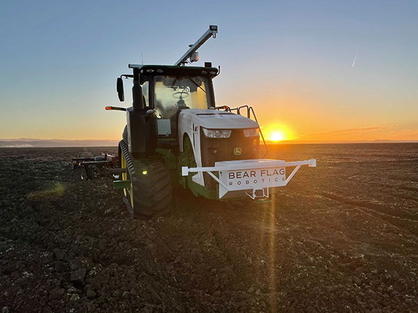
Deere & Company has signed a definitive agreement to acquire Bear Flag Robotics for $250 million USD. Founded in 2017, Bear Flag is a Silicon Valley-based startup that develops autonomous-driving technology compatible with existing machines.
The deal accelerates the development and delivery of automation and autonomy on the farm and supports John Deere’s long-term strategy to create smarter machines with advanced technology to support individual customer needs.
Deere first started working with Bear Flag in 2019 as part of the company’s Startup Collaborator program, an initiative focused on enhancing work with startup companies whose technology could add value for Deere customers. Since then, Bear Flag has successfully deployed its autonomous solution on a limited number of farms in the United States.
The Bear Flag team consists of agriculture professionals, engineers and technologists focused on autonomy, sensor fusion, vision, data, software and hardware. They will remain in Silicon Valley where they will work closely with Deere to accelerate innovation and autonomy for customers across the world.
Deal makes data from 40 Chinese satellites available through UP42 now, another 40 by late 2021
UP42 has signed an agreement with HEAD Aerospace of Beijing to make image data from more than 40 Chinese Earth Observation satellites available on the UP42 marketplace.
The broad selection of imaging capabilities from the constellations dramatically expands the range of applications in multiple sectors, with the most significant benefits expected in infrastructure, transportation, utilities, agriculture and government.
The UP42 marketplace contains more than 50 geospatial data sets, including satellite imagery from six international organizations. The newly added satellites’ diverse and often unique imaging capabilities include wide-swath imaging at very high resolution, nighttime acquisitions, frequent intraday revisits, tri-stereo collection and hyperspectral imaging.
“This partnership is an important milestone for us as a company but, more importantly, for our customers. By diversifying our data sets, we are unlocking a broader spectrum of use cases for our users in multiple sectors. This is the true meaning of ‘democratizing access to Earth insights’,” said UP42 CEO Sean Wiid.
HEAD Aerospace is an international distributor of satellite imagery collected by commercial Earth Observation missions. The UP42-HEAD agreement includes imagery from multiple constellations, including SuperView, Earthscanner, Gaofen-7, DailyVision, NightVision, Hyperscan, and Tri-Stereo ZY3. These seven constellations will total more than 80 satellites by the end of 2021.
“Sharing a similar approach facilitating users’ easy access to an agnostic data source by a centralized portal with a wide choice of satellite attributes, we are glad to have partnered with UP42. This partnership represents another new milestone for us in expanding our global network.” said Kammy Brun, managing director of HEAD Aerospace.
While each satellite constellation was designed with one or more imaging specialties, a remarkable variety of operational capabilities are shared across the constellations to support numerous applications and industries. Examples include:
Large-Area Very High-Resolution Mapping – Planning and monitoring critical infrastructure, including utility transmission grids and transportation networks, can be performed for entire states, countries and regions. Up to 40,000 square kilometers can be covered with wide-swath (136 km) imagery captured at a half-meter spatial resolution on a single pass.
Intraday and Early Morning Monitoring – The EarlyEye tasking product leverages multiple HEAD Aerospace constellations to deliver early-morning frequent images, an hour earlier than usual commercial offer at 10:30 a.m. Designed for frequent monitoring of critical assets and rapidly changing situations related to energy security, defense/intelligence and infrastructure management, a high-resolution revisit schedule of four times per day is possible, with 15-minute revisit between 09:00 and 13:30 anywhere on Earth to be possible by the end of 2021.
High Vertical Accuracy Mapping – Multiple satellites perform stereo imaging at high resolution for high-quality land use and cadastral mapping. One constellation captures single-pass tri-stereo imagery validated with onboard laser altimetry data, generating digital elevation models (DEMs), digital terrain models (DTMs), and other large-scale 3D mapping products with vertical accuracy of 5 meters. Additionally, the SuperView constellation captures daily stereo imagery with vertical accuracy of better than 2 m.
Hyperspectral Imaging – Imaging in 25 spectral bands spanning the visible, near-infrared, and mid-infrared portions of the spectrum is designed for regional natural resource management: detecting crop stress and planning pesticide/fertilizer applications, species mapping of forests and vegetative land cover, and protecting environmentally sensitive areas. These data sets can also be used in agriculture monitoring, mineral exploration and water-quality monitoring.
Nighttime Imaging – Monitoring and surveillance activities by government entities, energy utilities and security organizations can be carried out around the clock with true-color, high-resolution at 1 m optical and video imaging during daylight and dark of night. Nighttime collection is suitable for surveillance such as illegal camping, border surveillance, change detection (especially in rapidly evolving events), powerline incidents and designing streetlight placement in urban settings. Day and night video can detect vehicle and ship movement.
UP42 users have a growing selection of satellite imagery to choose from on the geospatial marketplace. UP42 technical experts are available to assist customers in selecting the best data set to meet the needs of specific end-use applications in all industries and sectors. These experts can also help in tasking a satellite for new image acquisition or querying the archive to obtain existing imagery.
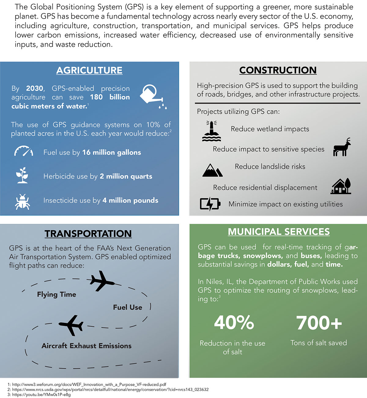
Can GPS support a greener, more sustainable planet? The answer is an emphatic “yes,” and it is already doing so today.
GPS has become a fundamental technology across nearly every sector of the U.S. economy, including agriculture, transportation, construction and municipal services. In each of these industries, the use of GPS has produced substantial environmental benefits, such as lowered carbon emissions, increased water efficiency, decreased use of environmentally sensitive inputs, and reduced waste.
Agriculture
Let’s take a closer look at how GPS is protecting our nation’s critical environmental resources. We begin with agriculture where it is estimated that the absence of GPS during peak planting season could result in an economic loss of more than $15 billion, according to a National Institute of Standards and Technology report.
During the past two decades, GPS has transformed American farming, enabling increased crop yields, cost efficiencies, and environmental sustainability through the precise application of seed, water, fertilizers and pesticides and the efficient use of fuel. In sum, precision agriculture lets farmers do more with less wasted seed, less fertilizer, less fuel, less pesticide, and more crop yield.
GPS Innovation Alliance (GPSIA) founding member Deere & Company reports that precision agriculture technologies can have a huge impact on resource efficiency and sustainability. By 2030, GPS-enabled precision agriculture implemented globally could save 180 billion cubic meters of water, says the World Economic Forum.
Similarly, according to the U.S. Department of Agriculture’s Natural Resources Conservation Service (NRCS), if “[GPS] guidance systems were used on 10 percent of the planted acres in the United States, fuel use would be cut by 16 million gallons, herbicide use by two million quarts, and insecticide use by four million pounds per year.” For a single Midwest row crop farmer, with 6,500 acres using precision agriculture techniques, Deere & Company estimates that more than 1,600 gallons of fuel could be saved, and more than 400,000 kg CO2 equivalent emissions could be avoided, over the course of a production cycle — the equivalent of nearly a million (992,000) passenger car miles driven per year.
Infographic: GPS Innovation Alliance
Construction
Construction is another industry that has been revolutionized by GPS. Today, high-precision GPS is used to support the building of roads, bridges and other significant infrastructure projects. In 2019, testimony before the U.S. House Small Business Committee, an executive of GPSIA founding member Trimble described several examples of how digital construction technologies, including GPS, can more efficiently plan and execute complex construction projects.
In one such example from Southern California, the improvements “reduced the wetland impact by 58 acres; reduced the impact to sensitive species; reduced landslide risk; reduced residential displacement; and minimized the impact on existing utilities (resulting in few utility relocations to undisturbed areas).”
GPS receivers are also embedded in many bulldozers, excavators and graders, resulting in reduced waste and lower fuel consumption. They can reduce greenhouse gas emissions, with an estimate from Trimble suggesting that the use of machine control technologies can cut more than one billion pounds of CO2 usage per year.
NextGen Air
GPS is also at the heart of the Next Generation Air Transportation System, or NextGen, of the Federal Aviation Administration (FAA). Capt. Sully Sullenberger, during a 2020 GPSIA-sponsored event, described air traffic control modernization as depending “massively on the ubiquity and reliability of GPS.”
Along with the safety benefits of knowing the precise location of an aircraft, GPS enables optimized flight paths that the FAA says can reduce “flying time, fuel use, and aircraft exhaust emissions.” These efficiencies have already resulted in $1.2 billion in fuel savings, according to the FAA.
During a 2010 test flight over Puget Sound, Washington, Alaska Airlines found that the use of GPS-aided flight procedures reduced emissions by 35% compared to a conventional landing. Other airlines have also quantified these benefits, finding substantial savings in fuel consumption simply by cutting a single minute from each flight.
Weather and Disaster Forecasts
No one can argue the fact that weather events like hurricanes, floods and droughts have a huge impact on the environment and public safety. According to the National Oceanographic and Atmospheric Administration (NOAA), in 2020 such events cost $95 billion in damages. You may not realize, however, that NOAA uses GPS signals to support three-dimensional meteorology, space weather and geophysical applications throughout the United States.
Even NOAA’s Geostationary Operational Environmental Satellites (GOES) use GPS signals to enhance their ability to provide the data we all receive in each morning’s TV weather forecast, improving weather predictions and our own storm situational awareness. GPSIA member Lockheed Martin manufactures both the GOES-R series of weather satellites and the U.S. Space Force’s more powerful, next-generation GPS III satellites that are now being launched to modernize the GPS constellation.
Municipalities
Lastly, we examine the environmental benefits for municipalities that use GPS for key government services, including the real-time tracking of garbage trucks, snowplows and buses. Throughout the country, towns and cities have seen substantial savings in dollars, fuel and time from implementing GPS-enabled technologies.
In Niles, Illinois, for example, the Department of Public Works partnered with GPSIA founding member Garmin to optimize the routing of snowplows. Using GPS technology, drivers reduced the use of salt by as much as 40%, resulting in more than 700 tons saved. In 2020, in recognition of its innovative use of GPS, the department received the Management Innovation Award from the American Public Works Association. Similarly, GPSIA member CalAmp found that GPS use for vehicle tracking can result in fuel savings of $90 per vehicle per month.
Ensuring GPS
Ensuring these environmental benefits can continue to be realized requires that the spectrum used by GPS be protected from harmful interference. It will also depend on continued funding by Congress to modernize the GPS constellation and ground control. Additionally, as Congress considers a major infrastructure bill, including funding for states and localities, we would encourage projects to make use of GPS and other innovative technologies that can drive down costs, reduce carbon emissions, and eliminate waste — including advanced digital-construction management systems that use GPS data to reduce project costs and speed project delivery.
GPS has changed our everyday lives for the better, and as our dependence on this technology continues to grow, so will its impact on environmental sustainability efforts.
The European GNSS Agency (GSA), with the European Commission, has published an information note on the Galileo High Accuracy Service (HAS). The 16-page document provides an overview of the main characteristics of the service, information on features such as service levels, target performance, an implementation roadmap, and an overview of the target markets for the service.
Target markets for Galileo HAS include geomatics, precision agriculture, consumer solutions and the space sector.
The market for high-accuracy positioning is dynamic, driven by various factors, including
emerging applications such as autonomous vehicles and drones;
technological advances such as dual-frequency chipsets for the mass-market; and
the market situation, with cheap or free-of-charge augmentation services available in some countries.
These factors are resulting in the democratization of high accuracy, which is becoming a more widespread commodity, rather than the exclusive domain of professional applications.
With the Galileo HAS, Galileo will pioneer a worldwide, free high-accuracy positioning service aimed at applications that require higher performance than that offered by the Galileo Open Service.
Benefitting several markets
Target markets for the HAS include geomatics, agriculture or consumer solutions. Transport is also a major potential target market, with possible applications in aviation, road, rail and maritime and inland waterways.
In these markets, the HAS will provide high-accuracy precise point positioning corrections for Galileo and GPS free of charge, in the Galileo E6-B data component and by terrestrial means, to achieve real-time improved user positioning performances, with a positioning error of less than two decimetres in nominal conditions.
“With its High Accuracy Service, Galileo will be the first satellite constellation able to provide a high-accuracy precise point positioning service globally, directly through the Signal in Space,” said GSA Executive Director Rodrigo da Costa. “This will be another key differentiator of the Galileo system, giving it a competitive advantage over other systems and allowing it to foster innovation in both consolidated and emerging markets.”
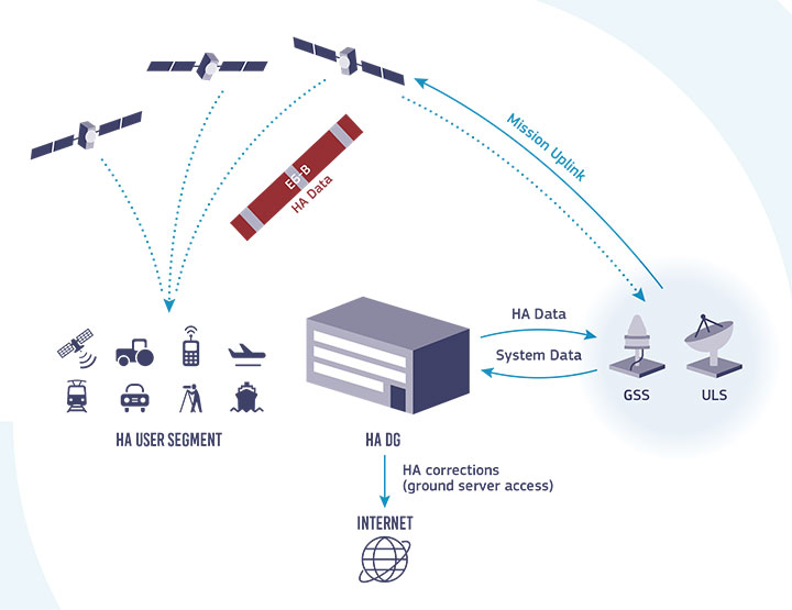
Galileo HAS high-level architecture. (Image: GSA)
HAS Initial Service
HAS Phase 1 will cover the provision of an initial Galileo HAS resulting from the implementation of a high-accuracy data-generation system that processes Galileo data only.
Phase 2 will see full provision of the Galileo HAS, meeting its target performance of 20-cm worldwide positioning accuracy after 2024.
Through the HAS, Galileo will offer a unique service with the transmission of corrections directly via Galileo satellites, allowing free high-accuracy positioning globally, for everyone.
New service provides PPP convergence for centimeter-level accuracy on land, air and marine applications around the world
Research from Hexagon’s Autonomy & Positioning division has resulted in breakthrough innovations in precise point positioning (PPP) that enable nearly instant global centimeter-level accuracy. These developments pave the way to bring “RTK from the Sky” performance to worldwide users through correction service products and GNSS receivers from Hexagon.
RTK from the Sky technology provides the quick accuracy of an RTK solution with the high accessibility and availability of PPP. Users will no longer have geographic or regional infrastructure restrictions — they will be free to operate anywhere around the world with the same premium level of positioning performance.
RTK from the Sky technology removes the traditional PPP barrier of long convergence times as well as internet and radio communication limitations, delivering instantaneous convergence anywhere in the world. This breakthrough establishes the foundation for assured positioning with no downtime in marine, agriculture, and autonomous applications.
To achieve these results, there must be masterful attention to detail throughout the entire positioning ecosystem: no errors conveniently cancelled and no errors ignored. All errors are carefully estimated and removed from the final GNSS position faster and more reliably than ever before.
This end-to-end fine-tuning of measurement quality and error mitigation establishes the foundation for RTK from the Sky performance. No matter the location or application, users will be able to rely upon the highest availability and accuracy of corrections anywhere in the world, without the convergence time, Hexagon said.
“In 2020, PPP has become RTK — without the mobility limitations,” said Sandy Kennedy, VP of Innovation at Hexagon’s Autonomy & Positioning division. “RTK from the Sky has been a very satisfying development. To see this kind of positioning performance available anywhere in the world is the realization of the next step of innovation for GNSS.”
RTK from the Sky technology will be the foundation for future correction service products and applications from Hexagon built for diverse applications.
Last week, 27 members of the U.S. House Agriculture Committee sent a letter to Federal Communications Commission (FCC) Chairman Ajit Pai. In it, they urged him to reconsider the FCC’s decision to allow Ligado Networks to operate a terrestrial nationwide network that the executive branch says will cause harmful interference to GPS signals for many users.
This concern and opposition from a sector not traditionally engaged in GPS or positioning, navigation and timing (PNT) issues is just one example of how the FCC’s decision — rather than putting the issue to rest — has instead recruited a whole new set of actors from across multiple sectors for the opposition.
Many observers don’t see this as surprising.
According to one observer, previously it was easy for many to assume the FCC would reject Ligado’s proposal. The entire executive branch had been vehemently opposed for years. So had aviation groups, the weather community, geospatial interests and some satellite communications concerns. With such opposition from so many important quarters, it was reasonable for many to assume they need not become involved. Now that the FCC has acted to the contrary, these interests have become well energized.
The FCC decision also empowered opponents to educate and recruit others who don’t normally think or worry about GPS and PNT issues, folks like farmers and agricultural interests.
As one insider said, “The existing opposition can now go to just about anyone in any sector and say, ‘This is going to happen and it will harm your operation. There are no ifs, ands, or buts. The FCC has decided’.”
Photo: Avalon_Studio/E+/Getty Images
Agriculture’s reliance on GPS
Agriculture is a good example. While not the sector that first springs to mind when most people think about GPS, farming has become dependent on augmented GPS for precisely and automatically driving machinery, minimizing fertilizer and pesticide use, and a wide variety of other productivity gains over pre-GPS operations.
“GPS is critically important to the commercial agriculture, mining, forestry and rural manufacturing industries. In fact, GPS has become the single most significant technological advancement for American farm equipment in the past two decades… [A 2019 RTI study] found that during planting season, if GPS were interrupted, the economic impact to the agriculture sector could amount to losses of $15 billion due to lower crop yields. Moreover, an earlier study suggested GPS-enabled precision agriculture could save farmers an estimated 10 to 15 percent in operating costs and purchased inputs. This same study estimated the benefits of GPS to precision agriculture between $10 and $17 billion.”
Department of Transportation studies have shown that high-precision GPS receivers, such as those used in agriculture, could be impacted within 3,000 meters of a Ligado transmitters. With tens of thousands of transmitters deployed in a nationwide network, this could pose a real problem for American farming.
Other sectors have also become involved in the opposition. The recently formed Keep GPS Working Coalition has members representing aviation, surface transportation, maritime, agriculture and equipment manufacturing.
This formal and public coalition, though, seems to be just the tip of the opposition iceberg.
Almost 100 dissenting organizations
According to some involved with protesting the FCC’s decision, there are nearly a hundred organizations and companies that are working in some way to have it overturned. These include multiple aviation, delivery service, agriculture, surface transportation, geospatial, weather, maritime, space and technology interests.
One sign of the influence they are having is an increase in concerns being expressed by members of Congress.
In addition to the agriculture letter, some of the most powerful recent examples are statements made during meetings of the influential House Committee on Appropriations. Rep. Ken Calvert (R-CA), ranking member of the Defense Appropriations subcommittee, spoke at length in opposition to the FCC’s action. His comments were followed in a similar vein by the vice chair of the Appropriations Committee, Rep. Peter Aguilar (D-CA).
Many of the questions being asked by the public and members of Congress alike were reflected in the letter from the Agriculture Committee members:
How did the FCC know that “its” tests were representative and valid?
Why does the FCC find that some degradation of GPS reception is acceptable?
Why did the FCC reject the executive branch’s testing criteria?
Was there a cost/benefit analysis?
The letter also asked the question that is on almost everyone’s mind: If and when there are problems, who is going to fix them?
Hitec Commercial Drone Services expects to provide training, precision aerial missions and comprehensive data collection to a variety of industries, including
agriculture, construction, excavation, mining and aggregates, oil and gas, engineering and surveying, public safety and many other vertical sectors. Hitec maintains a fleet of unmanned vehicles. It offers proprietary mission-control software and data and photogrammetry collection techniques with its comprehensive unmanned aviation experience.
The new division’s field services director is Jim Bonnardel, an innovative entrepreneur with a history steeped in unmanned flight. Bonnardel established his own successful business in 1982, providing aerial services to business-to-business entities. His inventive nature and extensive flying prowess led him to become a certified and insured UAS service pilot and instructor.
Bonnardel has logged more than 1,750 precision mapping missions, inspected 2,000 utility structures, and flown more than 2,500 commercial and residential property shoots, as well as dozens of missions for creative projects involving both television and music videos.
He is also an instructor at Grossmont College in El Cajon, California. He has provided 850 hours of commercial instruction, as well as 550 hours of instructional field training and vetting for utility inspection crews. As a result of his training experience, Jim has issued 150 sUAS Utility Training Certificates.
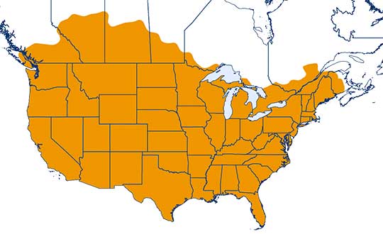
One-inch GNSS accuracy in under a minute, delivering seamless high-precision performance across the U.S. and southern Canada
Trimble has completed expanding its CenterPoint RTX Fast correction service, with coverage now spanning the contiguous U.S. and southern Canada. This expansion is central to Trimble’s vision to transform how and where users can leverage precision and accuracy.
Coverage of Centerpoint RTX Fast. (Image: Trimble)
Designed for autonomous applications in both on-road and off-road markets, the coverage and performance of the service enables industry professionals to re-think what is possible when using augmented positioning for improving safety, performance, productivity and operational efficiency.
The CenterPoint RTX Fast subscription service delivers horizontal positioning accuracy of 1 inch (2 centimeters) or less in under a minute, with the versatility of satellite or cellular delivery. This expanded coverage makes it the largest, high-performance GNSS correction network in the world, according to Trimble.
Base stations not required. The service encompasses more than 5 million square miles across North America and Europe. By using the service, said Trimble, farmers, land surveyors and GIS professionals can untether from the cost and complexities of GNSS base stations.
In addition, Trimble RTX Fast offers a single, continuous correction technology platform for enabling a broad range of safety-critical autonomous applications in markets such as automotive, agriculture and construction.
“This achievement is a major milestone in the continuous evolution of our correction service and autonomy strategy. We are delivering unmatched access to fast, reliable, highly accurate positioning in more areas than ever before,” said Patricia Boothe, senior vice president of Trimble’s Autonomy Sector. “Whether enhancing performance in the autonomy ecosystem or simplifying traditional mapping and surveying workflows, RTX Fast users can gain greater accuracy to improve productivity and operate safely — ultimately transforming the way they work and drive.”
CenterPoint RTX Fast subscriptions for Trimble RTX-compatible GNSS receivers are available through Trimble’s Authorized Business Partners or Trimble’s online store.
According to the company, Trimble Dimensions is the signature event for Trimble’s global user community spanning agriculture, construction, geospatial, transportation, utilities and more. The show highlights technology and how it transforms the way professionals work to achieve success.
“Unfortunately, the overwhelming concerns and ongoing impact of COVID-19 inhibit our ability to deliver a conference that meets the high standards of safety and excellence our attendees expect and deserve,” Trimble said in a press release.
The event was scheduled to take place Nov. 2-4 at the Gaylord Opryland Resort and Convention Center in Nashville, Tennessee. Trimble Dimensions is a biennial event.
New series of free webinars for construction, geopositioning and agriculture facilitate learning
Topcon Positioning Group is launching a free webinar program for the construction, geopositioning and agricultural sectors, exploring key topics affecting the industry and providing the latest updates and project management solutions.
The Topcon Talks series, consisting of numerous informative webinars, has been created in response to the ongoing COVID-19 pandemic and aims to provide those working from home with valuable educational resources, while maintaining steady communication with Topcon customers, dealers and the wider industry.
The webinars will focus on a range of topics such as improving productivity using digital construction workflows, overcoming barriers to technology adoption, and more practical how-to sessions for customers and dealers on specific Topcon solutions.
The webinars will be delivered by a range of Topcon experts, with input from several other industry specialists, and cover a multitude of topics including:
Always One Step Ahead – an overview of Topcon’s latest product developments, market focuses and acquisitions
State of the Industry series – looking at the barriers to technology adoption in construction, such as attracting talent and bridging the skills gap
Detailed technical sessions showcasing latest hardware, software and web services to get the most out of Topcon solutions
The content series is live on the site, with new sessions taking place regularly over the coming weeks. All sessions are free to attend, and those wanting to participate will first need to register on the Topcon website.
“Everyday life has changed very quickly, and businesses across the world are having to adapt. At Topcon, we are working tirelessly to help the industry weather this storm. We’re aware that at this time, the majority of people are working from home, and we want to continue to support our customers and colleagues as much as possible,” said Ron Oberlander, vice president of global professional services at Topcon Positioning Group. “That’s why we’ve developed this webinar series — to provide an opportunity for continued professional development so that professionals can remain as productive as possible during this challenging time and be in the best position possible to accelerate the industry’s recovery when we come out the other side.”
The webinars are also recorded and uploaded to the site once complete, so those who are unable to attend the session can access the content in their own time.
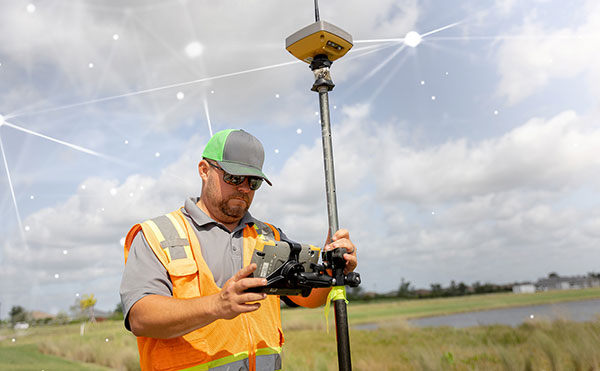
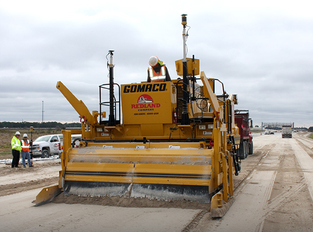
GNSS, coupled with inertial systems and software, is enabling greater accuracy in construction and agriculture. Other markets using machine control include unmanned vehicles, mining, surveying, mapping and defense.
At construction sites, GNSS receivers can be found in heavy equipment such as bulldozers, excavators, graders and pavers. On farms and in orchards, GNSS increases productivity of machines ranging from tractors to UAVs.
A new MarketsandMarkets report predicts the machine control system market will grow to $6.6 billion by 2024, a compound annual growth rate (CAGR) of 8.16%.
For precision agriculture, the outlook is even brighter. Grand View Research anticipates the market will reach $12.9 billion by 2027, a CAGR of 13% over the period.
Machine control speeds projects and increases efficiency under tight timelines. Using GNSS to guide the heavy lifting also alleviates safety concerns related to workers and construction machinery, and provides situational awareness to field operators.
In this month’s feature, we share case studies from companies that specialize in these markets, provide product details, and review the status of real-time kinematic (RTK) GNSS in agriculture.
Check out some use cases for how GNSS, inertial systems and software are enabling greater accuracy in construction and agriculture.