Tag: agriculture

  • HYBRiX UAVs could benefit farming production

    HYBRiX UAVs could benefit farming production

    Photo: Quaternium
    Photo: Quaternium

    The use of drones for precision agriculture is gaining momentum because of their capability to deliver the most updated information fast and efficiently. UAVs are transforming how agriculture is done. By implementing drone technology, farms and agriculture businesses can improve crop profit, save time, and make land-management decisions that improves long-term success.

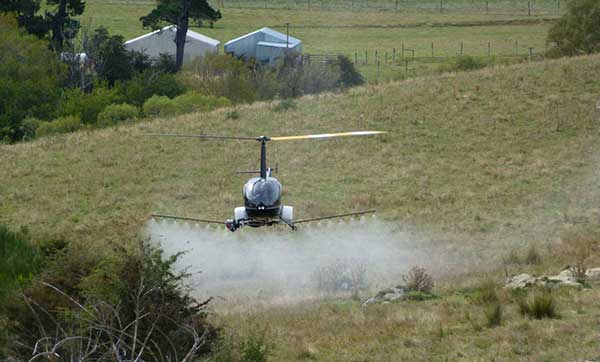
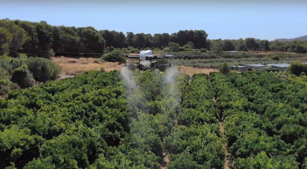
    A few weeks ago Quaternium tested its innovative HYBRiX drone to spray fertilizers in the orange fields near Valencia, Spain. With its system of longer-than-average flight-duration, farmers have the opportunity to monitor and spray their fields precisely and rapidly.

    “I am really glad to see that the entire spraying process in my orange fields has hardly taken six hours,” said farmer Pedro Andreu while operating the HYBRiX. “With other drones, we had to spend multiple hours waiting for batteries to charge and days to finish the work.”

    The test convinced Andreu to use the technology to simplify his work. He engaged farmers in the neighborhood to join him and implement this technology in their work as well.

    Alicia Fuentes, Quaternium CEO, accompanied the team for the field demonstration. She noted that farmers could benefit by using precision farming technology in a variety of ways: monitoring the health of their crops, estimating soil conditions, planting future crops, fighting infections and pests, updating the health of plants, and livestock monitoring.

    Hybrid fuel system. HYBRiX UAS operates using a hybrid electric-fuel system. This makes it easy to operate the multi-rotor drone through the fields of a farm for an entire work whole day by refilling the spraying tank when needed and the fuel tank every 2-3 hours. Its built-in capacity of 5 liters of fuel enables HYBRiX to surpass the flying time from minutes to 2 to 4 hours.

    The powerful propulsion system of HYBRiX allows the aircraft to carry up to 10 liters of liquid, with a maximum takeoff weight of 25 kg. The combination of hybrid power with its increased range extender capacity allows the farmer to cover large acres of land without carrying uncomfortable batteries and ensure long flight time in the field with the aircraft.

    Quaternium is now focused on refining this technology to extend crop protection across the country so that farmers can benefit from the outcome to make their work more efficient.

  • Robinson helicopter converted for UAV precision farming

    Robinson helicopter converted for UAV precision farming

    UAVOS has added the R22-UV unmanned helicopter to its agriculture unmanned aircraft portfolio for spraying for diseases, weed and pest control, and vegetation control.

    The R22-UV is a manned Robinson-22 helicopter converted by UAVOS to an unmanned aircraft. (Photo: UAVOS)
    The R22-UV is a manned Robinson-22 helicopter converted by UAVOS to an unmanned aircraft. (Photo: UAVOS)

    The Agro-Drone R22-UV is equipped with a specially developed utility to deliver liquid chemicals — the spray system Simplex model 222.

    The R22-UV drone is provided with a 100-liter tank for chemicals and can stay airborne for two hours. Weight of the system is 42 kilograms, boom span is 7 meters, and swath width is 14 to 16 meters.

    UAVOS listed several advantages that could maximize the value of such a heavy UAV for farmers:

    • The R22-UV can be operated in the regions without airfields, under severe weather conditions and during night-time, in conditions with a high probability of risk for the pilot.
    • UAVs are excellent for operations in conditions of high humidity, where the use of ground equipment is impossible or difficult. Unlike heavy machinery, which cannot go into a field immediately after a heavy rain, UAV has no impact on the ground. Drone sprayers don’t touch the ground so there will be less soil compaction. This is when heavy machinery like tractors roll over the soil, pressing it down and damaging it. Farmers can fix this with plowing, but it can be harmful to the soil over a long period of time.
    • UAV implementation eliminates manual spraying with backpack sprayers, so workers don’t come into contact with hazardous chemicals.
    • UAVs also enable growers to spray their crops precisely and at will, which is critical for fighting herbicide-resistant weeds. Spraying is better. The rotor of an agricultural drone produces a huge downward rotation force, which promotes the pesticide droplets to penetrate the crop from top to bottom, which is conducive to the pesticide droplets evenly scattered in all parts of the plant, so that the spraying is accurate.
    • Unmanned aircraft can be used for spot spraying weeds with herbicides and are useful for spraying crops with pesticides. A spot-oriented approach based on preliminary analysis of digital images from robot cameras minimizes the cost of agrochemicals, reducing the chemical impact on soil, water, culture and, ultimately, on the consumer’s body, while achieving higher results of crop cultivation than with traditional approaches. The aircraft can be set on a predetermined GPS-defined route to fly over a field, dropping doses of pesticides, herbicides and fungicides as it flies.

    “Precision agriculture is based on the use of valuable metrics to make farmers’ crop management efficient and optimized,” said Aliaksei Stratsilatau, CEO of UAVOS. “Validating-of-damage reports used to be on paper. So, unmanned aircraft help our customers to validate the veracity of reports so that we could come up with a comprehensive solution. Generally, agriculture is very complex and there are a lot of problems, but there are solutions available through the new technology.”

  • NovAtel firmware release delivers enhanced signal acquisition, accuracy

    NovAtel firmware release delivers enhanced signal acquisition, accuracy

    NovAtel, part of Hexagon’s Positioning Intelligence division, now brings users greatly improved processing speed and accuracy as well as significantly reduced signal acquisition time through the latest 7.07.03 firmware release.

    The SPAN CPT7. (Photo: NovAtel)
    The SPAN CPT7. (Photo: NovAtel)

    The firmware works best with the recently launched TerraStar-X correction service, which delivers accuracy and reliability, as well as the OEM7, SPAN CPT7 and PwrPak7 products, which use signals from all GNSS constellations and frequencies to provide users with reliable autonomy and exceptional positioning availability.

    The 7.07.03 firmware offers a significant improvement to the SPAN GNSS + INS (inertial navigation system) technology. SPAN with 7.07.03 shows improvements of up to 20% in the horizontal position over the entire SPAN IMU catalog and across various industry use cases including agriculture and marine. SPAN with 7.07.03 also provides improved motion detection, resulting in more robust time to convergence.

    “The 7.07.03 firmware features improvements to both our SPAN Marine and SPAN Rail profiles that will greatly impact application performance and consistency,” noted NovAtel Director of Product Management, Neil Gerein, “The SPAN Marine Profile sees improvements to the heave performance and will allow users to start their work significantly faster thanks to a simplified setup for applications in marine dynamics. The SPAN Rail Profile improves position accuracy over long GNSS outages, which is crucial for applications in rail environments that often deal with potential signal obstructions such as trees, tunnels and dense urban areas.”

    To download the 7.07.03 firmware update for your platform, click here.

  • Galileo satellites to bring boost to Case IH AFS RTK+ users

    Agriculture equipment maker ​Case IH is enhancing the robustness of its RTK+ correction signal network by adding the European Galileo system to the compatible satellites with which it works.

    The move will increase levels of signal reception and reliability for farmers using Case IH RTK+-guided autosteering and related technologies.

    Real-time kinematic (RTK) systems typically depend on signals from the American GPS or Russian GLONASS satellite networks, both designed primarily for non-civilian use. To give European Case IH users a reliable alternative when using RTK+-guided steering systems with their sub-1.5-centimeter repeatable accuracy, Case IH AFS RTK+ now also uses Galileo.

    The addition of Galileo to the global GNSS constellation helps minimize the risk of signal failure, a key driver for the integration of its signals into the Case IH AFS RTK+ signal system. European satellite network independence is a principal objective, but Case IH AFS RTK+ is also designed to be compatible with existing and planned GNSS satellites and interoperable with GPS and GLONASS.

    Galileo benefits farmers by minimizing downtime from waiting for lost signals to be regained, and ensures consistent efficient use of seed, fertilizer and crop protection products through parallel passes with minimal overlap, thereby maximizing crop potential.

    “The use of GNSS technology is opening up new productivity levels and opportunities in European agriculture, providing farmers with an unprecedented level of knowledge about their crops, livestock and operations while making the sector more efficient, economically competitive and environmentally sustainable,” said Maxime Rocaboy, product marketing manager, AFS technology, at Case IH.

    “Enhanced RTK+ accuracy through incorporation of signals from the Galileo satellite system is a core way in which we can help Case IH tractor and combine users be innovative and competitive as they seek to help develop a sustainable agriculture to feed an ever-increasing world population in an environmentally responsible way,” Rocaboy said.

  • Boosting EGNOS for better precision farming

    Boosting EGNOS for better precision farming

    Precision agriculture depends on the precise positioning of augmented GNSS. In Europe, this augmentation is provided by the European Geostationary Navigation Overlay Service (EGNOS).

    Although EGNOS is widely available in Europe, coverage is lacking in remote and rural areas.

    To help fill the needs of farms in these areas, the Horizon 2020 AUDITOR project, funded by the European GNSS Agency (GSA), is developing a ground-based GNSS augmentation system that will deliver high-performance and cost-efficient services and applications for the agriculture industry.

    “The purpose of this project is to develop an improved GNSS ground-based augmentation system using modern and proven algorithms in highly configurable, cost-effect receivers,” said Project Coordinator Esther Lopez. “As a result, AUDITOR will enable cost-effective precision agriculture services for farmers, especially those with small and mid-sized farms in areas where EGNOS availability is limited.”

    The AUDITOR system is based on a radio frequency (RF) dual-band multi-constellation GNSS front-end and an embedded digital processing platform. The front-end receiver acquires the GNSS signals and embeds all analog and digital hardware required to convert the RF signal to digital samples.

    The digital processing platform then converts and customizes the signals for the AUDITOR systems. The system serves as the basis for providing higher level services for the end user via cloud-based web and mobile applications.

    Autonomous Future. With AUDITOR applications, farmers will be able to accurately measure spatial variability in soils and crops. Yield maps will allow farmers to precisely apply fertilizer, water and pesticides, reducing production costs and environmental impact.

    AUDITOR’s high-accuracy positioning will also enable the use of autonomous mobile robotic units for identifying weeds, pests and diseases, GSA said.

    “Producing precise maps of the soil and crops, as well as the spatially varying application of fertilizer that these maps enable, is completely dependent on the availability of an augmented GNSS signal,” Lopez said. “Thanks to AUDITOR, even areas in Eastern and Southern Europe that once were unable to get the required precise GNSS signal can reap the benefits of precision agriculture.”

    With the ever-increasing requirement for augmented yield and profitability and energy and cost savings, the future of farming is precision agriculture. By focusing on providing the augmentation needed to enable existing precision agriculture applications in Europe alone, Lopez is confident that AUDITOR will be well-positioned to compete on the market.


    This article is reprinted with permission of the European GNSS Agency (GSA).

  • Hexagon offers intelligent cultivation management for agriculture

    Hexagon, a global provider of information technology solutions, has launched HxGN AgrOn Production, an integrated cultivation management solution that empowers customers to optimize resource efficiency, increase yield, reduce inputs and ensure quality.

    The solution is comprised of software and hardware solutions that optimize and automate entire crop cycles from planning to cultivation.

    Hexagon officially revealed HxGN AgrOn Production today at Agrishow, one of the world’s largest agricultural technology fairs in the world taking place in Ribeirão Preto, Brazil.

    “Real-time information is the key to efficient field management. HxGN AgrOn Production brings immediate benefits to agricultural and forestry companies — providing instant control of all stages of the cultivation process and enabling resource optimisation and efficiency,” said Ola Rollén, president and CEO of Hexagon.

    According to the company, the solution will enable Hexagon’s customers to achieve a smarter cultivation by connecting, synchronizing and optimizing workflows, teams and information while reducing operating costs.

    HxGN AgrOn Production addresses resource management challenges of enterprise farms and is a future-proof investment in information technology innovations that are enabling the smart digital reality in agriculture.

  • Beta program opens for Pix4Dfields for agriculture

    Pix4D has announced Pix4Dfields, its first fully dedicated product for agriculture. A beta program to test the software is now open.

    Pix4Dfields is designed to give users fast and accurate maps while in the field, with a simple yet powerful interface fully dedicated to agriculture.

    “When we decided to create a fully dedicated product for agriculture, we wanted to go beyond the research and development and create a product that actually understands agriculture,” the company said in a press release. “So in July 2017, we opened a new office in Berlin fully dedicated to do exactly that: Understand the agriculture industry, listen to our users, and create a product that caters to all the main agricultural practices.”

    Pix4Dfields is equipped with fast processing that provides accurate and instant results and an easy-to-use interface with tools tailored to agricultural workflows.

    Pix4Dfields is currently available as a closed beta, which we are opening to select users to test it and provide feedback. The product will evolve at a fast pace with new and updated features being added with every new iteration, the company said

    Pix4Dfields is currently available for macOS only; the next iterations will include Windows support as well.

    To join the beta program or learn more, visit the website.

  • Taoglas launches comprehensive range of high-precision GNSS antennas

    Taoglas launches comprehensive range of high-precision GNSS antennas

    The BOLT A.90.A.10451111. (Image: Taoglas)

    Taoglas, a provider of IoT and M2M antenna products, has launched a range of high-performance GNSS antennas specifically designed to power the next generation of applications that require highly accurate location capabilities.

    These applications include navigation, unmanned aerial vehicles (UAVs), surveying, agriculture, connected cars and autonomous vehicles.

    The new antenna range is Taoglas’ most comprehensive series of high-precision GNSS antennas and incorporates new form factors and use of multiple RF bands.

    Taoglas’ new range includes systems and antennas that use Galileo, GLONASS and BeiDou, as well as GPS L2 or L5 bands.

    “Today’s connected devices and applications demand new ways of approaching the age-old problem of location accuracy,” said Dermot O’Shea, co-CEO for Taoglas. “In certain applications, there is simply no room for positioning errors — location accuracy is an absolute requirement.”

    The GRS.10 smart antenna. (Image: Taoglas)

    The new antenna range includes:

    • The GRS.10, a smart antenna that includes a high-performance Taoglas GNSS (GPS, GLONASS, Galileo, BeiDou) ceramic patch antenna module integrated with a u-blox NEO-M8U GNSS receiver.
    • The Torpedo series GNSS quadrifilar helical antennas, extremely high-performance wideband satellite antennas for position-information-critical applications. It provides high circularly polarized antenna gain across a wide beamwidth. These are available in a passive (QHA) or active (AQHA) versions.
    • The BOLT A.90.A.10451111, a new GNSS timing antenna that includes lightning-induced surge protection. It is designed for the base station market. The advantage over other timing antennas is the addition of GLONASS and BeiDou frequencies.

    The complete range of precision GNSS antennas also includes:

    • The MAT.12A. (Image: Taoglas)

      The ASFGP.36A.07.0100C, a ceramic GPS L1/L2 low-profile, low-axial-ratio, embedded stacked active patch antenna.

    • The MAT.12A, a GPS/GLONASS/BeiDou dueling-loop chip antenna evaluation board, which delivers the advantages of a circularly polarized patch antenna with two miniaturized low-profile chip antennas on a smaller PCB footprint at one-fifth the weight.

    This week, Taoglas also launched small form-factor ultra-wideband (UWB) antennas designed to work with DecaWave’s chipset and module solutions for applications including asset tracking, follow-me drones, healthcare monitoring, smart home services and other applications that demand high-performance indoor localization capabilities.

    Taoglas’ complete range of GNSS and UWB antennas will be on display in Booth N.614 at Mobile World Congress Americas, Sept. 12-14, in San Francisco.

  • Harxon introduces all-constellation GNSS antenna for surveying and mapping

    Harxon introduces all-constellation GNSS antenna for surveying and mapping

    Harxon has released the all-constellation GNSS antenna GPS1000, receiving GPS L1/L2/L5, BDS B1/B2/B3, GLONASS L1/L2, Galileo E1/E2/E5a/E5b and L-band signals.

    GPS1000 can be used in land survey, marine survey, channel survey, seismic monitoring, bridge survey and agriculture applications, providing consistent performance across the full bandwidth, the company said.

    The antenna has high gain and wide beam width to ensure the signal receiving performance of satellite at the low elevation angle, and the phase center remains constant as the azimuth and elevation angle of the satellites change.

    Placement and installation of the antenna can be completed with ease because the signal reception is unaffected by the rotation of the antenna or satellite elevation. The influence of measurement error can be minimized via the multi-feed design and embedded multipath rejection board.

    The GPS1000 waterproof and dustproof design has reached a standard of IP67, maintaining good performance for long-time outdoor operation.

    Moreover, the advanced low noise amplifier can reduce jamming by high-power out-of-band transmitters. It can be customized for the best solution for customers, Harxon said.

  • VADER + Atlas help troubleshoot on the job

    Hemisphere’s Atlas-enabled Platinum VADER smart antenna.

    Plantium, in Santa Fe, Argentina, is a full-service provider of precision agricultural guidance systems to some of Argentina’s largest farming operations.

    The company makes its own guidance and control devices, installs them and offers farmers real-time, remote support if required. Plantium uses the Atlas GNSS Global Correction Service as the primary means of providing precise, real-time location corrections to its customers, and their receivers are based on Atlas-ready OEM boards from Hemisphere GNSS.

    “We design, manufacture and sell precision agriculture systems,” said Federico Baulies, robotics engineer for Platinum. “As a part of our SBOX7 + DirectDrive + VADER system, Atlas really helps with all of these. Atlas tools give us the ability to diagnose and solve problems in real-time — probably its best feature.”

    “As soon as we hear of an issue, from operators or from alarms built into our monitors, we can collect several working variables — such as interference and satellite noise — immediately, from our offices, and diagnose many problems instantly,” Baulies explained.

    Argentine farmers benefit from remote problem-solving with the Hemisphere Atlas-enabled Platinum VADER smart antenna.

    “That means we do not have to wait for 30 minutes to see if our client will get convergence — we know right away. A lot of that capacity is built right into the Hemisphere OEM boards or from the way the Atlas service is designed.

    “These diagnostic tools also help on the customer’s end,” Baulies said. “The Atlas service and Hemisphere’s OEM boards make clear user interfaces possible, and end users are rarely confused about the state of their equipment.”

    Once a problem is diagnosed, Plantium engineers can implement fixes quickly, using cellular connectivity.

    “We can often diagnose and fix a problem remotely, sometimes in the same phone call,” Baulies said.

  • Hexagon launches HxGN AgrOn Logistics harvest solution for sugarcane, forestry

    Hexagon launches HxGN AgrOn Logistics harvest solution for sugarcane, forestry

    Hexagon, a global provider of information technology solutions, has launched HxGN AgrOn Logistics, an end-to-end solution enabling sugarcane and forestry producers to manage and optimize the complex logistics processes essential to harvest.

    HxGN AgrOn Logistics will be officially unveiled today at Agrishow, one of the world´s largest agricultural technology trade shows, in Ribeiro Preto, Brazil.

    “In agriculture and forestry operations, success is defined by productivity,” said Hexagon President and CEO Ola Rollén. “Efficiently moving product from field to processing is one of the most critical phases of production, and one filled with logistical risks. HxGN AgrOn Logistics is streamlining and optimizing this entire process,”

    AgrOn Logistics simplifies harvest with communications, insights and operations that are continuously optimized — from planning to field to processing. Real-time communications between machines enable easy coordination, while advanced software handles monitoring, capacity planning, scheduling, dispatching, resource management and more intensive data analysis.

    The benefit to sugarcane and forestry harvest operators is complete connectivity, with workflow synchronization that optimizes every step of the process – from planning to dispatching to real-time execution and full machine automation.

    Field-tested by more than 70 producers, AgrOn Logistics users are experiencing steep productivity gains and sharp decreases in raw materials loss, Hexagon said,

    HxGN AgrOn Logistics will put data to work for a more intelligent approach to harvest: connecting, synchronizing and optimizing workflows, people and information while reducing operating expenses.

  • DroneDeploy integrates with agX on UAV mapping flights

    DroneDeploy, a cloud software platform for commercial drones, is integrating with agX to help growers more easily capture field maps and analyze aerial data.

    agX users can now share field boundaries saved in agX with DroneDeploy to simplify the planning of drone mapping flights. Over time, agX and DroneDeploy plan to integrate further to allow seamless sharing of drone images from DroneDeploy to agX.

    “This integration will provide agX users an efficient method of combining high-quality UAV [unmanned aerial vehicle] imagery from DroneDeploy with other agronomic data to assist in decision-making that can add to a grower’s bottom line,” said Shawn Peterson, business development lead at agX. “Integrating quality imagery into an operation brings tremendous value by showing the varying conditions of the crop throughout the field. We are excited DroneDeploy will join the platform to offer imagery solutions that bring value to UAV applications.”

    agX users can exchange field boundaries between DroneDeploy and other agX Compliant applications, allowing them to centrally store, access and share field boundaries. In the future, DroneDeploy’s integration will offer users the ability to share field data and imagery layers.

    DroneDeploy makes drones accessible and productive tools that help growers save time and create actionable insights. Using DroneDeploy, a grower can automatically fly and capture drone imagery, create a field map and analyze crop variability in hours to help make timely management decisions.

    “DroneDeploy makes it fast and easy for growers to capture aerial data,” said Scott Lumish, vice president of business development at DroneDeploy. “Integrations with tools like agX help growers turn that data into action.”

    agX helps growers and service providers stay connected to various precision agricultural applications. Users can access and share their data within agX Compliant applications to save time and reduce duplicate data entry. Anyone can create a free agX account.

    Support for DroneDeploy imagery transfer will be added to agX in early of summer 2017.